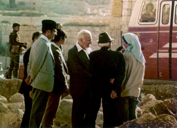
This is a question that is frequently asked at this time of the year. We are told that after his crucifixion on Golgotha, the body of Jesus was laid in a new tomb, but he was raised from the dead three days later.
Golgotha in the foreground with the Temple Mount looking eastThe new tomb in which Jesus was laid before the stone was moved to close the opening.
The resurrection of Christ was an important event that gives hope to many Christian believers, including ourselves.
However, from an archaeological point of view, I am interested to know how the tomb of Jesus was sealed. We know the story as recorded in the Gospels:
Matt. 27:62-66 On the next day, which followed the Day of Preparation, the chief priests and Pharisees gathered together to Pilate, saying, “Sir, we remember, while He was still alive, how that deceiver said, ‘After three days I will rise.’ Therefore command that the tomb be made secure until the third day, lest His disciples come by night and steal Him away, and say to the people, “He has risen from the dead.’ So, the last deception will be worse than the first.” Pilate said to them, “You have a guard; go your way, make it as secure as you know how.” So, they went and made the tomb secure, sealing the stone and setting the guard. (NKJV)
There are images on the internet that show ropes around the rolling stone or metal bars, but nothing would be strong enough to prevent such a large and heavy stone from being moved by a few strong men.
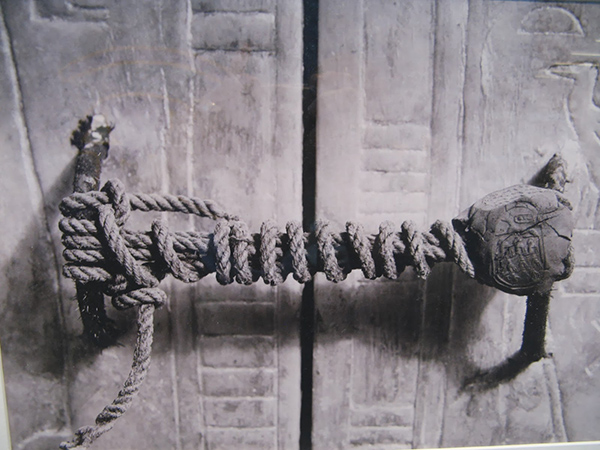
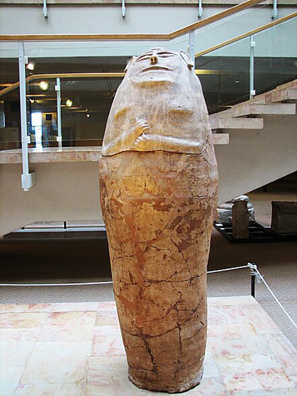
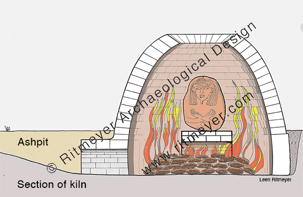
As I was researching this topic, I came across an image that shows the seal securing the entrance to a shrine of gilded wood that belonged to the Egyptian Pharaoh Tutankhamun. The handles of the two doors were secured together by a rope and a seal.
On the right handle was a clay seal featuring Anubis , the Egyptian god of funerary rites and protector of the gates to the underworld.
Again, such a piece of rope would not have prevented anybody from entering the tomb chamber. After more than three millennia, the seal was finally broken by Egyptologist Howard Carter in the early 1920’s.
The important thing about this sealing rope is not the rope itself, but the clay seal that is attached to the door handle on the right. This shows the authority of the person who had ordered the sealing, and anybody trying to break that seal would be accountable and suffer the consequences.
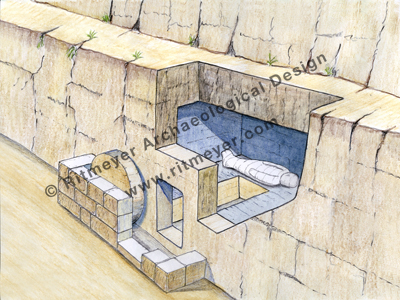
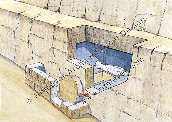
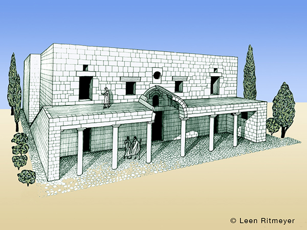
In this image, the stone has been rolled in front of the opening to the new tomb. A seal was then attached between the stone and the front of the tomb.
The tomb of Jesus was sealed on the authority of the High Priest which was either Annas or Caiaphas. The tomb was sealed using two patches of wax connected with a piece of rope. People knew that anybody breaking that seal would be held accountable to the High Priest. From a factual point of view, the string was ineffective, but the authority of the High Priest would have been respected. However, angels are not subject to this authority. Their only desire is to do the will of God. The earthquake that is described in Matthew 28:2 was brought about by the angel of the Lord who had descended from heaven. He would have been the one who broke the seal and rolled back the stone from the door.
At the same time Jesus was raised from the dead in fulfilment of Psalm 16:10-11:
“For You will not leave my soul in the grave, nor will You allow Your Holy One to see corruption. You will show me the path of life; in Your presence is fullness of joy; at Your right hand are pleasures forevermore.”
Jesus never sinned during his life on earth and was rewarded with immortality. Let us then follow Christ who suffered for us, leaving us an example, that we should follow His steps.
The Pool of Siloam is best known from the New Testament where Jesus sent the blind man to wash and be healed (John 9:7-11). In the Hebrew Bible this pool is mentioned as the “waters of Shiloah that flow softly” (Isaiah 8:6). The waters originated from the Gihon Spring, but that was apparently forgotten in the 1st century as Josephus calls this pool a fountain. In the last couple of decades it was thought that the Pool of Siloam was the stepped pool that has become a major tourist attraction in Jerusalem.
However, my friend Dr. David E. Graves alerted me to a recent article by Nathan Steinmeyer in Biblical Archaeological Society’s Bible History Daily called “Rethinking the Pool of Siloam.”
“Where is the Pool of Siloam? If you visit the City of David Archaeological Park in Jerusalem, you would easily think it is the large pool formerly known as Birkat el-Hamra, that has been excavated since 2004 near the southern end of the ridge. However, Israel Antiquities Authority archaeologist Nahshon Szanton believes this identification is almost certainly incorrect. Publishing in the journal ‘Atiqot, Szanton instead identifies the true Pool of Siloam with the more traditional Pool of Silwan, which is located only a few hundred feet to the north of Birkat el-Ḥamra.”
Szanton suggests that the square colonnaded pool that was excavated by Bliss and Dickie in 1896, should be identified as the Pool of Siloam mentioned by Josephus in War 5.140 as the “fountain of sweet and abundant water”, and that the water reservoir was Solomon’s Pool mentioned by Josephus in War 5.145.
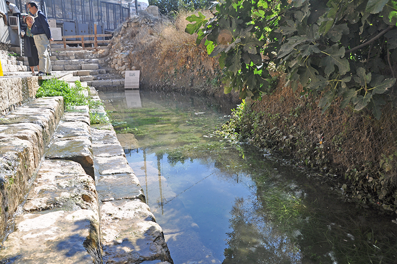
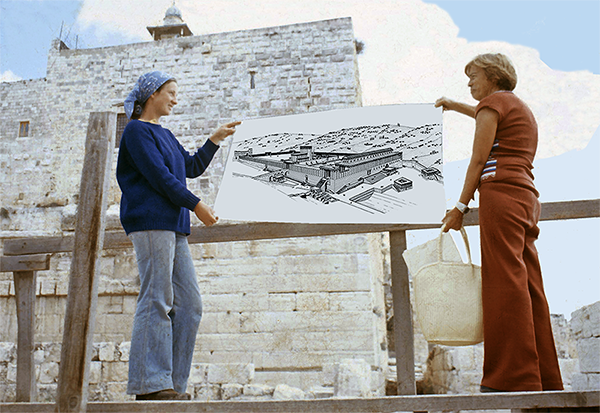
In the context of my work at the Temple Mount Excavations, I visited the Pool of Siloam many times and studied the plans made by Bliss and Dickie, and those of Charles Warren. One of the ancient walls of this pool is still visible today.
In the centre of the photo is an ancient ashlar wall topped by a moulding. Photo taken during my first visit in 1973.
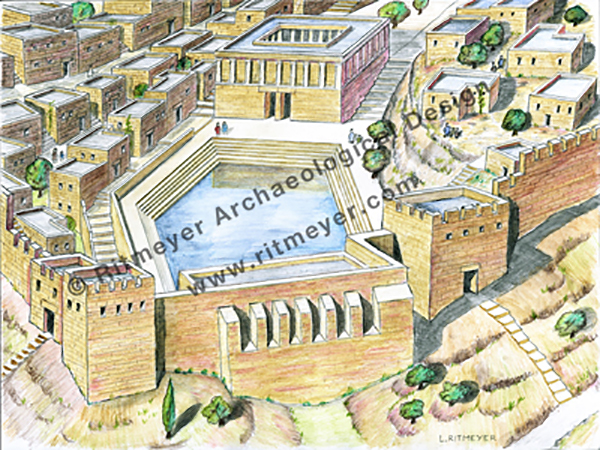
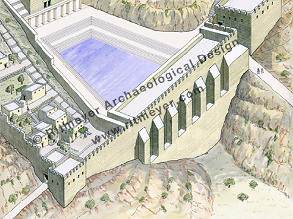
We have argued for a long time that the excavated remains of a square colonnaded pool discovered by Bliss and Dickie in 1896 had a ritual function, and that the stepped pool was a water reservoir. The Pool of Siloam was built near the exit of Hezekiah’s Tunnel. This tunnel was dug at the time of King Hezekiah to bring water to the western side of the city. He also created a huge water reservoir by building a city wall at the end of the Tyropoeon or Central Valley that also funtioned as a dam. This, in turn, made it possible for the city to extend to the west. By building a city wall round the Western Hill and securing its water supply, it became possible for the city to more than double its size.
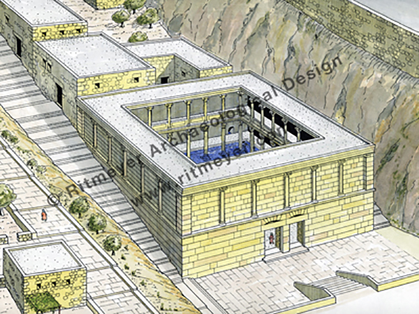
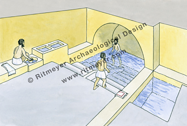
This reconstruction drawing of the Pool of Siloam, dating from the first century, is based on the excavations of Bliss and Dickie . According to their plan, the almost square pool had a double entrance that indicates a ritual function. The double entrance gave access to a colonnaded porch that was built round a pool. It received water from Hezekiah’s Tunnel. This, I believe, was the building in which the blind man washed and was healed by Jesus.
Many mikvaot – Hebrew for ritual baths, mikveh in the singular, – have been excavated in Jerusalem and elsewhere in Israel. A mikveh usually takes the form of a stepped pool carved out of the rock with a small dividing wall built on the upper steps. The more elaborate mikvaot had double entrances. The purpose of this was to allow users of the mikveh to descend on one side and, after immersion, ascend on the other side, thus preventing contact with those who were not yet purified.
Washing and bathing are important parts of Jewish ritual and are referred to in the Gospels, e.g. Matthew 15.2 and John 9.7.Here we see the water reservoir in the foreground and the Pool of Siloam higher up.
Although we had incorporated the excavated steps all along the three walls of Birkat el-Ḥamra in our reconstruction drawings, only the steps on the east (right in the drawing) have been excavated. Since last year the whole of the area at the lower end of the Tyropoeon Valley has been excavated, but none of the proposed steps on the west have been found.
A stepped pool was discovered at the mouth of the Central or Tyropoeon Valley, which is located between the Western and Eastern Hills of Jerusalem. This large pool served as one of the water reservoirs of Jerusalem. The building with the double entrance at the top of the drawing had a religious function.
The absence of steps on the west strengthens our idea of a water reservoir with steps on one side only. Other water reservoirs in Jerusalem, such as the Pools of Bethesda and the Pool of Israel could be accesses from one side only.
Strabo wrote that Jerusalem was a “city well-watered within, but desert outside” (Geography 16:2:40). The history of Jerusalem can be presented in many ways, but the most critical factor in understanding the development of the city is based on the capacity of the ancients to provide its inhabitants with water. Water was the central resource that shaped the fortunes of the city. Jerusalem began around the Gihon Spring, after which many new water systems were created throughout the ages in order to keep pace with the growing population of the city.
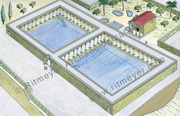
These large twin pools formed the Pools of Bethesda in Jerusalem, mentioned in John 5:2. Each of the pools had steps on one side only. Next to these large water reservoirs was a temple dedicated to Asclepius, the Roman snake god of healing. Around this small building were five sacred baths where sick people hoped to be healed. Jesus healed the paralytic man in this complex (John 5.2).
I don’t agree with Nahshon Szanton that this water reservoir could have been used as a swimming pool. Swimming was more likely used as a method of crossing rivers for example rather than for recreational purposes.
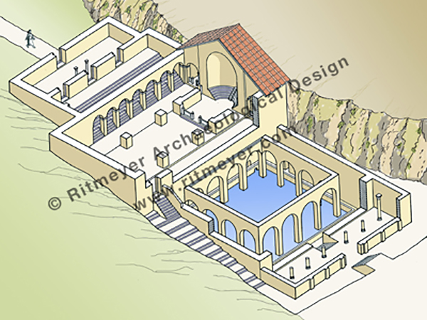
The sanctity of the Pool of Siloam was recognised in the Byzantine period by the building of a church next to the pool. The same happened at the conclusion of the excavations by Bliss and Dickie when a mosque was built over it.
In the Byzantine period, a church was erected above the Pool of Siloam. The pool could be reached from a door inside the church.
The construction of water reservoirs was necessary for making life in Jerusalem possible. No wonder that in Scripture, water is referred to as the water of life (Revelation 21:6; 22:1; 22:17).
The Archaeology of the Way of the Land of the Philistines
The war that Israel is waging against the Hamas terrorist organisation in the Gaza Strip has resulted in casualties of many innocent civilians on both sides of the conflict. We hope that this deplorable situation will end soon.
We do believe, however, that eventually there will be peace in the Middle East when the rod from the stem of Jesse shall come forth and a branch shall grow out of its roots and the Spirit of Yahweh shall rest upon the greater son of David, namely Jesus who shall judge the poor with righteousness as Isaiah says in Ch. 11.
Isaiah 11:11 “It shall come to pass in that day that the Lord shall set His hand again the second time to recover the remnant of His people who are left, from Assyria and Egypt, from Pathros and Cush, from Elam and Shinar, from Hamath and the islands of the sea.” And then Isaiah 11:16 “There will be a highway for the remnant of His people who will be left from Assyria, as it was for Israel in the day that he came up from the land of Egypt.”
At present it is impossible to imagine that there will be a highway from Assyria to Egypt, from Baghdad to Cairo, but in the Kingdom of God, these things will come to pass. That means that the international coastal highway between Africa and Mesopotamia, which is the topic of this blog, will be opened again.
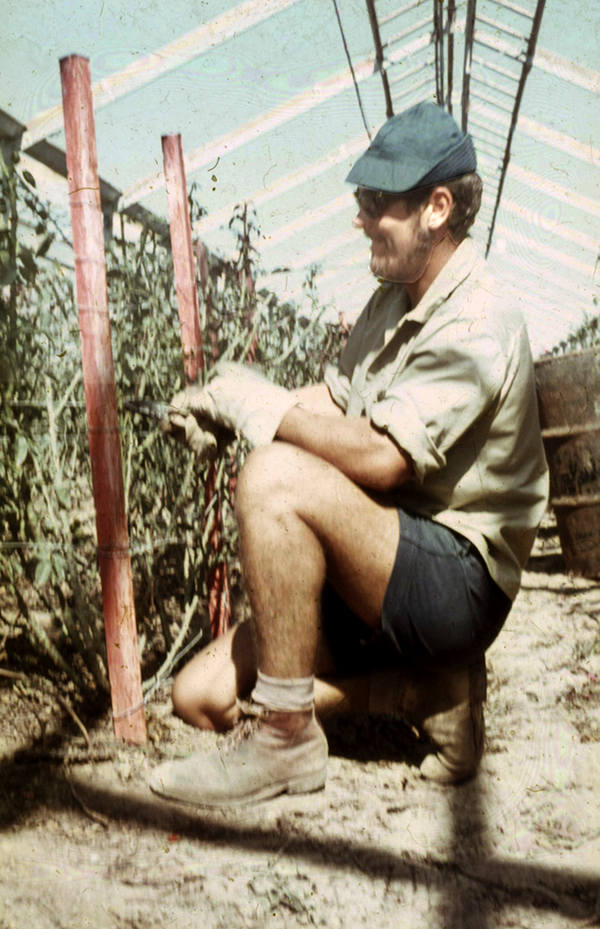
But back to the present. The Gaza Strip has been off bounds to Israelis since they evacuated the area in 2005. The situation was different when after the 1967 Six Day War, I worked as a volunteer in Kibbutz Yad Mordechai, which is near the northern border of the Gaza Strip.
Working in the greenhouses of Yad Mordechai where roses were grown for export to the Netherlands and Switzerland
There were no border controls at that time, and it took me less than an hour to walk to the centre of Gaza. Soon afterward, however, the entire Gaza Strip became off-limits to civilians.
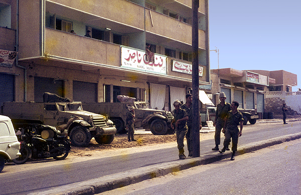
Israeli soldiers and two half-tracks in front of Nasir Hotel in Gaza. Photo: Leen Ritmeyer
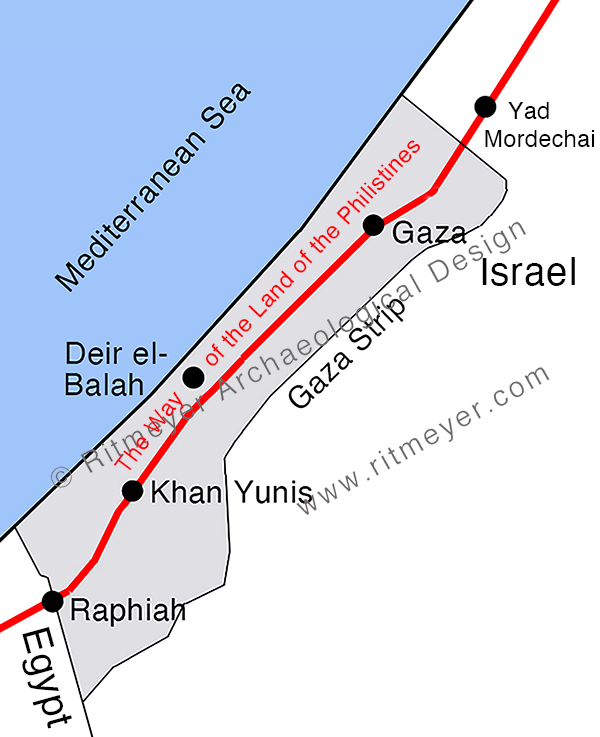
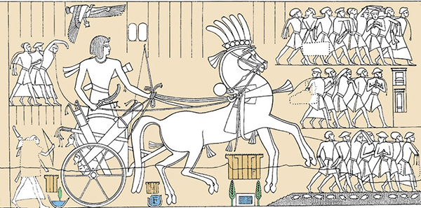
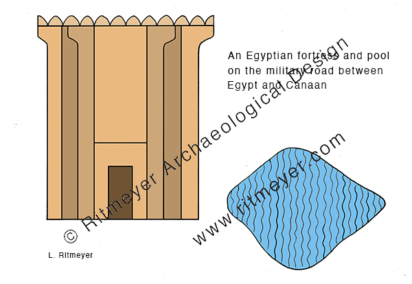
The Gaza Strip is rich in archaeological remains. The reason for this is that the great international coastal highway between Africa and Asia ran through this area. This great trunk road connected Egypt in the south with Syria and Mesopotamia in the north. It is one of the oldest roads in the world and is called the Way of Horus by the ancient Egyptians, and in the Bible, it is known as the Way of the Land of the Philistines (Ex. 13:17).
Numerous towns, fortresses and caravanserais were built along this road that runs a few miles inland due to the wide strip of sand dunes that lines the Mediterranean coast. Ancient armies, traders, caravans, and travellers moved along this road. Many biblical characters, such as Joseph, Jacob, and infant Jesus with Mary and Joseph, travelled along this road too.
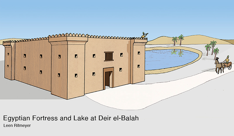
When the Israelites under leadership of Moses left Egypt, they were warned in Ex. 13:17 not to follow the “Way of the Land of the Philistines”, lest the people “change their minds when they see war and return to Egypt.” Archaeological discoveries have shown that they would have had to fight the Egyptian garrisons that were guarding this route. This road, known to the Egyptians as the “Way of Horus”, was the military road between Egypt and Land of Canaan as it was called then. Gaza was the capital of Canaan in the time of the New Kingdom in Egypt (1550–1077 BCE). This road appears in graphic form on the northern wall of the hypostyle hall at Karnak. It shows that strong fortifications were built along this road, a fact that has been verified by archaeological excavations. Prof. James Hoffmeier excavated the Migdol fortress in Egypt that was built at the beginning of this road, and I was involved in the excavations of one of the more northern fortresses, namely at Deir el-Balah in the Gaza Strip. This road was fortified by Seti I (1294-1279 BCE) and continued in use until the middle of the reign of Ramses II (1279-1213 BCE). The fact that the Israelites were told to avoid this road is a point in favour for the late date of the Exodus.
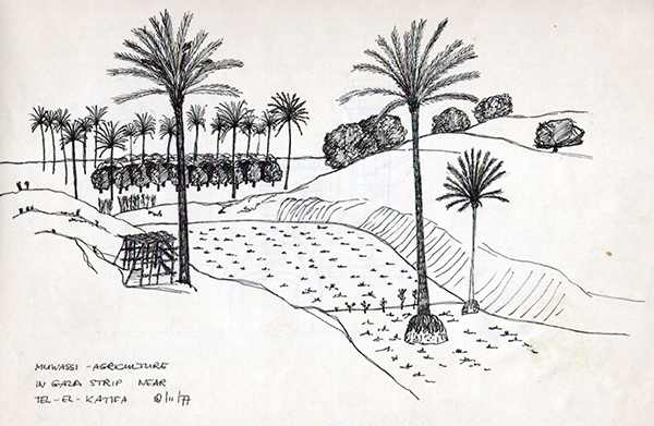
Places that we hear of in the news, such as Rafah (ancient Raphiah), Khan Yunis and Gaza are located on this ancient road. Ten years after my first visit to Gaza, I joined an archaeological tour and visited Gaza, Tel Katifa, Deir el-Balah, and Khan Yunis.
We were impressed by the muwassi hydroponic agriculture that we saw near Tel Katifa. The land in this area sits on an aquifer of sweet water. Bulldozers had been used to remove the sand dunes down to the original soil. As the sweet water floats to the surface above the heavier sea water, a fertile area was created where vegetables and other crops could be grown.
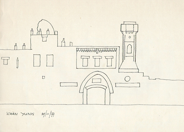
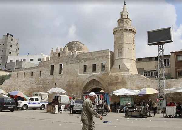
We then travelled south to Khan Yunis where I made a quick sketch of the Barquq caravanserai.
I was pleasantly surprised to see in a recent blog post by Brandon Marlon for the Times of Israel that the building still exists today.
The Barquq Caravanserai today
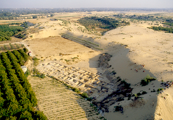
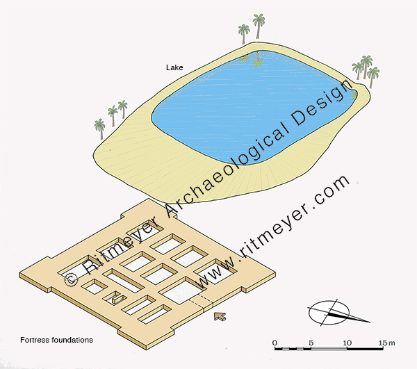
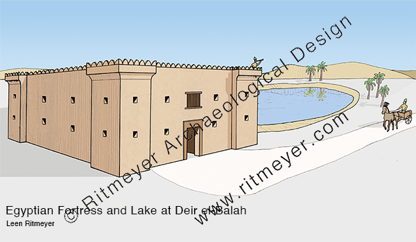
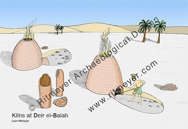
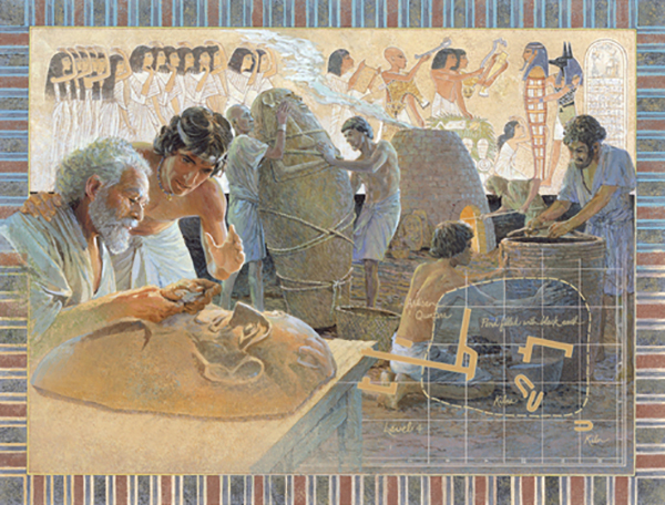
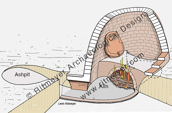
On our way back, we visited the excavations of Deir el-Balah. Prof. Trude Dothan of the Hebrew University carried out excavations of the site between 1972 and 1982. Remains of clay coffins were found and kilns in which anthropoid lids were fired. Additionally, the remains of a large fortress that measured 20m (66 feet) square were found and an adjacent lake or reservoir.
One year before the end of the excavations, in 1981, Trude asked me to make reconstruction drawings of the site for her final publication. These were later used by artist Lloyd Townsend of the National Geographic to illustrate Trude’s article “Gaza Sands Yield Lost Outpost of the Egyptian Empire” in the 1982 December issue. I recently digitised these drawings and colored them in.
In 1967, Trude Dothan saw many clay lids of anthropoid coffins that appeared in the antiquities shops in the Old City of Jerusalem. She noticed that fine grains of sand were embedded in the clay. This gave her the idea that they may have originated from the Gaza Strip or the Sinai desert. This was confirmed by Moshe Dayan who was defense minister at the time. Eventually she was allowed to conduct archaeological excavations at this site.
We hope that the present suffering will end soon, and that the “times of refreshing may come from the presence of the Lord, and that he may send the Christ appointed for you, Jesus, whom heaven must receive until the time for restoring all the things about which God spoke by the mouth of his holy prophets long ago.” (Acts 3:20,21).
Discovery of previously unknown Hebrew inscriptions
Arnon Segal, a journalist-friend from Jerusalem, sent me a link to a most interesting article he wrote for the Makor Rishon newspaper (Hebrew).
“A Muslim acquaintance from abroad, a lover of Israel and a devout Zionist named M.A. [name withheld for obvious reasons], visited the Temple Mount in recent years and photographed up close a series of sites that are not accessible to Jews there, and the Gate of Mercy in particular [The Golden Gate is called Sha’arhaRachamim, “The Gate of Mercy” in Hebrew]. He provided rare photos from there, including a sensational discovery that will be described below.”
Arnon and I met in Jerusalem, and he published articles about my work on the Temple Mount in this newspaper. In this present article he writes:
“The gate complex became a mosque almost five years ago, and since then changes have been made to it that pose a great danger to the antiquities located there. The Gate of Mercy, as it is called today, dates to the seventh century AD. However, researchers such as archaeologist Leen Ritmeyer are convinced that a gate has stood in this place since the days of the First Temple, in the seventh century BC, the days of Hezekiah. Ritmeyer suggests that the Mercy Gate is the gate known in the Mishnah as “the Shushan Gate”, through which the scapegoat went out into the desert, and from there the Red Heifer was taken to the Mount of Olives.”
The inscriptions that probably date back to the 9-11th century prove that Jews went up to the Temple Mount on, what must have been for some, a once-in-a-lifetime pilgrimage.
In the 19th century, Félicien, or Félix de Saulcy, a Frencharchaeologist, discovered an inscription in the underground Double Gate passageway. Jonah and Shavtia his wife, who had travelled from Sicily, wrote their names on the inside wall, with the addition of “strong in life”, meaning that they had prayed for a long life. Unfortunately, this inscription has recently almost been erased by a layer of new plaster.
In 1908, a well-known Jewish researcher discovered another Hebrew inscription on the southern wall of the Golden Gate, mentioning Abraham son of Loles, followed by the same formula “I will be strong”. This phrase means “getting stronger” and shows that Jews went up to the Temple Mount to give thanks for recovery of an illness.
“Benjamin of Tudela, who visited the Holy Land in the 12th century, mentioned this custom in the underground structure of Solomon’s Stables in the south of the mountain: “And there in Jerusalem, by the house where Solomon had horse stables built… the Jews who come there write their names on the wall.” “All of these appeared in the researchers’ articles in the last 170 years. Photographs provided by M”A from the Gate of Mercy structure recently prove that there are other ancient Hebrew inscriptions in the place, which the archaeological research has not caught up with yet .”
Photographs of the newly discovered inscriptions can be seen in the article, especially those written on the first column inside the gate.
“The archaeologist Tzachi Dvira believes that he was able, after seeing the photos taken at the site, to decipher some words from the inscriptions on the column. He reads there, among other things, the words “I have overcome”, and then a blurred word that may include the letters “for Bacher”. Next to these, the name “Reuben son of Machir” and the word “Degel- flag” were engraved on the column. Below them appears the name “Yosef (Joseph) son of …”, with his father’s name that is possibly Aryeh. It seems that another inscription appears beneath it in which the name “Yosef” is mentioned a second time, as well as other names, which are more difficult to identify.”
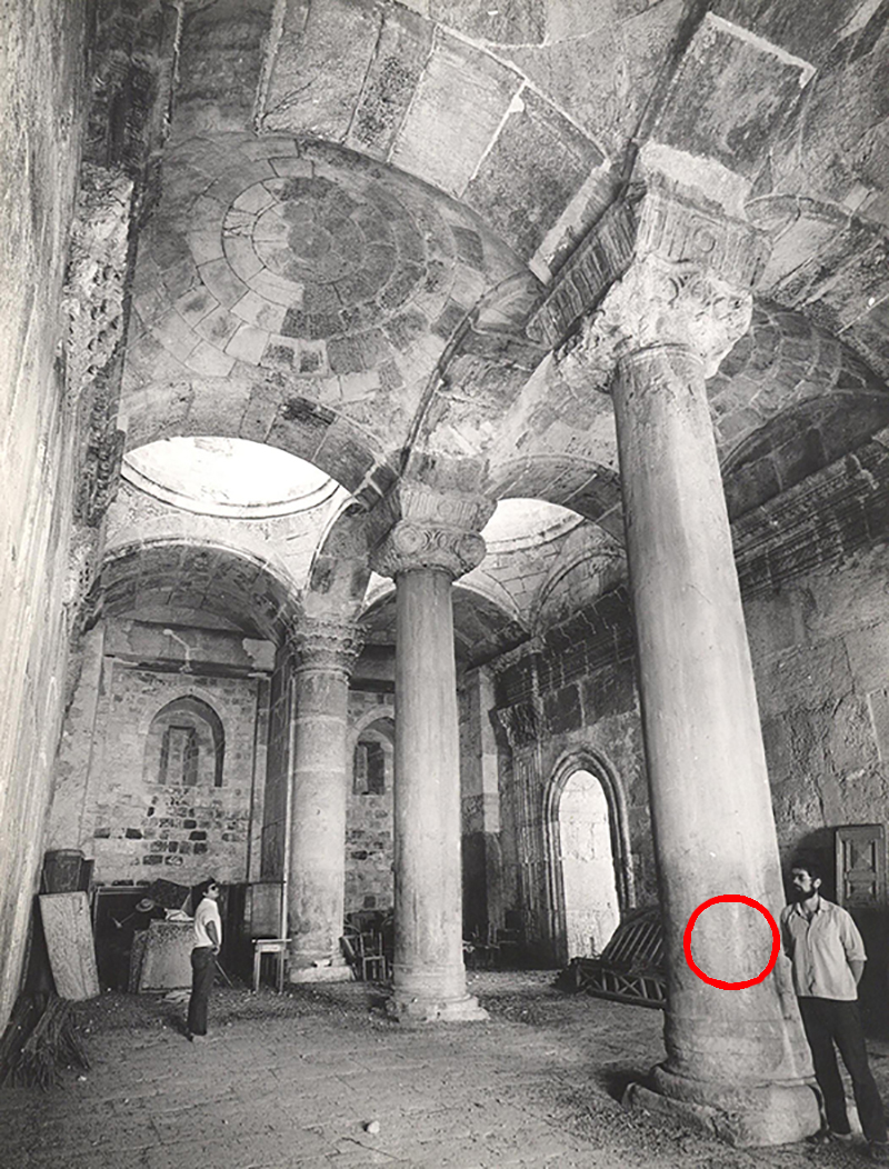
In 1975, I stood by this pillar (at right), unaware of the barely visible inscriptions right next to me. The red circle indicates the location where these inscriptions were found.
The letters are written in the so-called square Hebrew script that has been in use for many centuries. Even a pupil at a modern Hebrew school can easily read them. However, as Jews were allowed on the Temple Mount during the Early Muslim period from 838-1099 AD, but not afterwards, it is assumed that these newly discovered inscriptions date from that period.
Segal concludes his article with these words:
“So, in the heart of very sad days in our history, we received greetings from Jews who a thousand years ago went up to the Temple Mount freely. They engraved their names in the Gate of Mercy for eternal remembrance in the Temple of God.
“They roamed the place undisturbed, under the auspices of the very kind Muslim government of the 11th century, while we – the 21st century citizens of supposedly free Israel – are not allowed to go there.
“How did we come to terms with a reality where an address located in the heart of the free capital of Israel, not in Tehran or Baghdad, needs a Muslim to come here from abroad to reveal it to the world for the first time?”
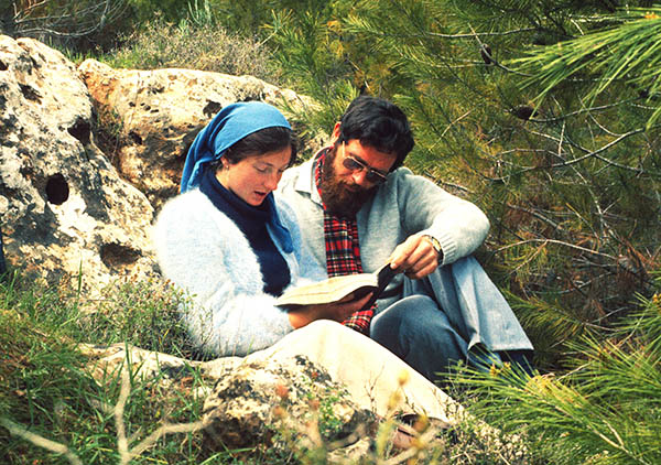
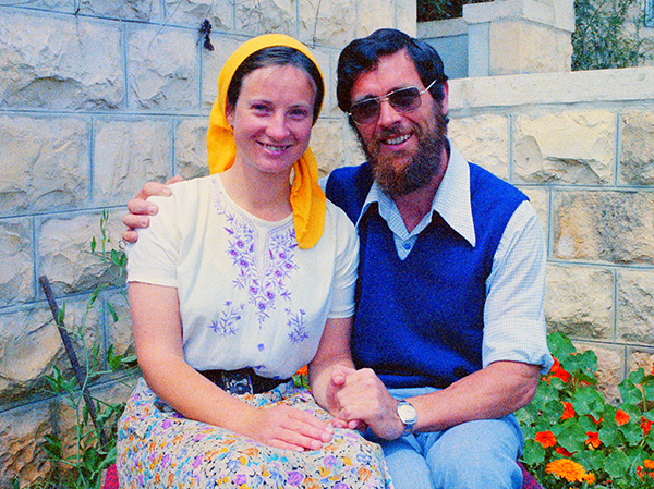
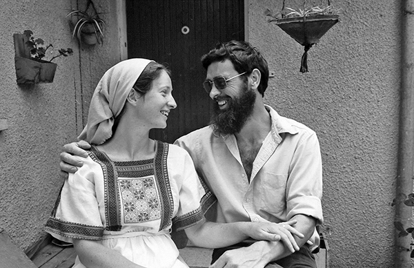
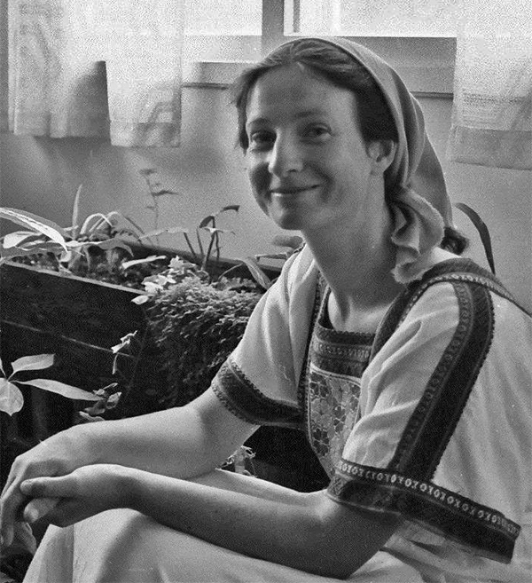
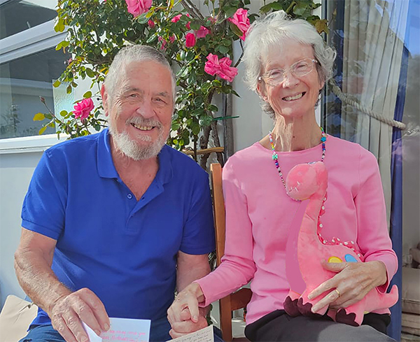
Today, the 1st of October 2023, Kathleen and I celebrate our 45th (sapphire) anniversary. We enjoyed many wonderful years of love, loyalty and dedication to each other, and shared interests in our faith, family, and archaeological work. We both love God’s Word, the Land of Israel and other biblical lands, and the Hebrew language. In many ways Kathleen (I call her Katia) is my equal and more, but she never wanted to attract attention to herself. All she ever wanted to do was to be my helpmeet. Katia was and always will be the “desire of my eyes”. Here is how it began.
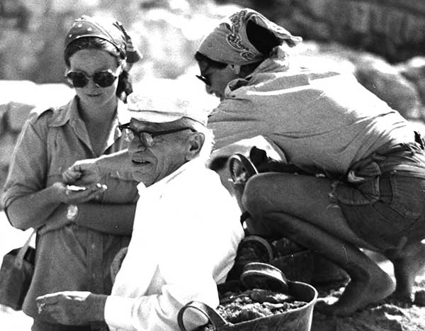
The 1st of October 1975 was exactly 48 years ago that Kathleen O’Mahony (BA Archaeology, University College Dublin, Ireland, PGCE) arrived at the southwest corner of the Temple Mount Excavations to join the introductory tour I was giving for new volunteers. Katia had come to work on the dig as archaeological supervisor and occasional surveyor.
Katia at left with Prof. Benjamin Mazar, director of the Temple Mount Excavations, in the foreground, and an American volunteer at right.
Drawing in Leon and Jill Uris’ book Jerusalem, Song of Songs, with Katia at left (coloured in).Meeting the then President of Israel, Ephraim Katzir. From right to left: Katia, Prof. Mazar, Ephraim Katzir.
Living in Jerusalem and seeing the variety of representatives of the different churches, she began wondering which of them was right. Katia also asked me what I believed, and so began many sessions of her asking questions and me answering from the Scriptures. We soon realised that our relationship was growing into something beyond teacher and student.
Reading the Song of Songs near Solomon’s Pools near Bethlehem.One thing led to another, and we fell madly in love, and still are. Exactly three years after we first met, we married on the 1st of October 1978.Just married in 1978. She loved her Druse dress.A very happy Katia with a lovely cheeky smile!45 years later.
We also celebrate 40 years of our Ritmeyer Archaeological Design (RAD) partnership. Katia is a professional archaeologist and excellent researcher, and her outstanding writing skills enabled us to co-author many books. We both love bringing the past to life, she with words and I with reconstruction drawings. We often reminisce about the many projects we have been involved with.
In the first year of our partnership, I joined the late Yizhar Hirschfeld in his search for Byzantine monasteries in the Judean Desert.
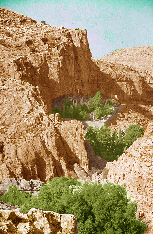
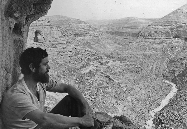
The Byzantine monastic movement in the Judean Desert was initiated in the 4th century AD by Chariton, who was born in Iconium (modern Konya, in Turkey). After the cessation of persecution of Christians, he made pilgrimage to Jerusalem, but was taken captive by bandits, who took him to a secret treasure cave in Pharan, near the spring of Ein Fara, not far from Anathoth (Arabic anata). Eventually he was rescued and inherited the cave and its contents and founded his first monastery there. I visited this monastery for the first time in 1970.
The Monastery of Pharan in 1970. It is located in the upper canyon section of Wadi Fara, near the spring of Ein Fara, about 6 miles (10km) northeast of Jerusalem, just beyond Anathoth.At that time, a monk called Alexander, at far right, was still living in this monastery. Soon after our visit he left for Vienna, and his monastery was unfortunately destroyed.
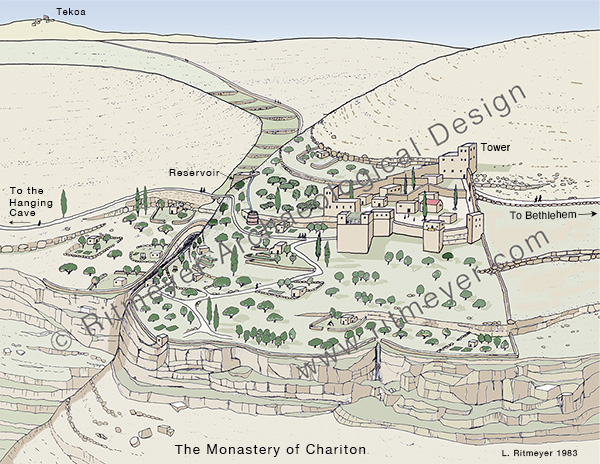
After leaving Pharan, Chariton established two other monasteries, the first one was the Laura of Douka, on the Mount of Temptation, and later the Monastery of Chariton – also called Souka, near Tekoa. The name of the monastery’s founder, Chariton, is preserved in the Arabic name of the site that is called Khirbet Khureitun and of the valley below, Nahal Khureitun. The modern name of the valley is Nahal Tekoa.
This laura monastery was established by Chariton above the steep cliffs of Mount Quruntul to the west of Jericho. The two cliffs descend to Nahal Khureitun, or Nahal Tekoa. The nucleus of the monastery is triangular in shape with a tower at each corner. As it was built on a steep slope, massive retaining walls had to be built along the base to create level areas for construction.
There are two types of monasteries, the laura (from the Greek word for path) is a community of monks who live in individual cells around the church and, walking over the paths that lead from their individual caves to the monastery, meet communally during the weekend. A coenobium (from the Greek koinos bios, meaning communal life) monastery is an enclosed complex where the monks live, work, pray and eat together. Chariton sought solitude in the last years of his life which he spent in the Hanging Cell of St. Chariton.
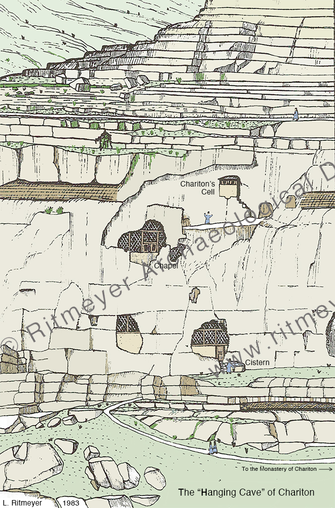
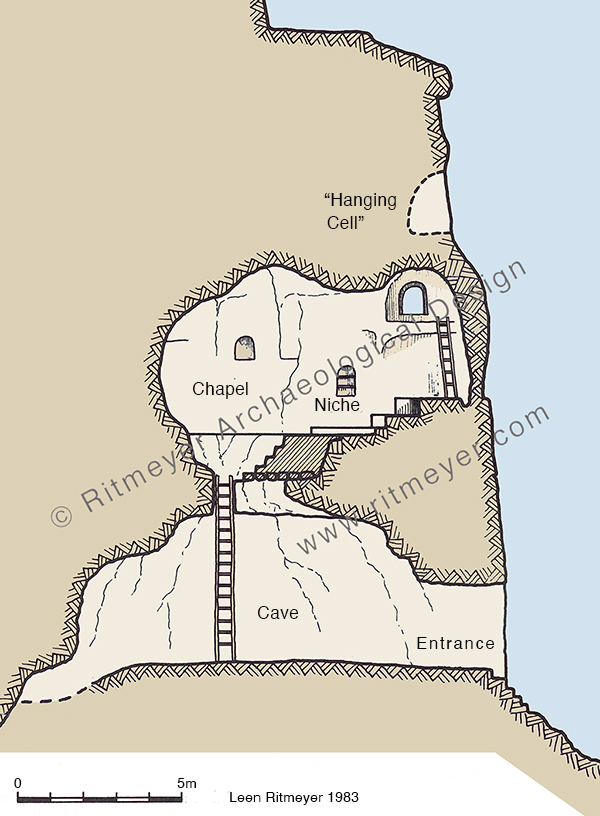
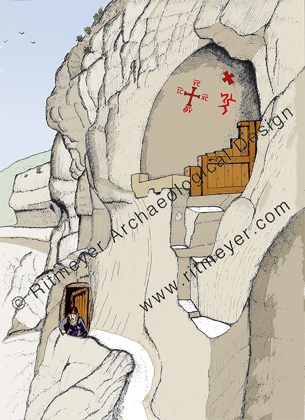
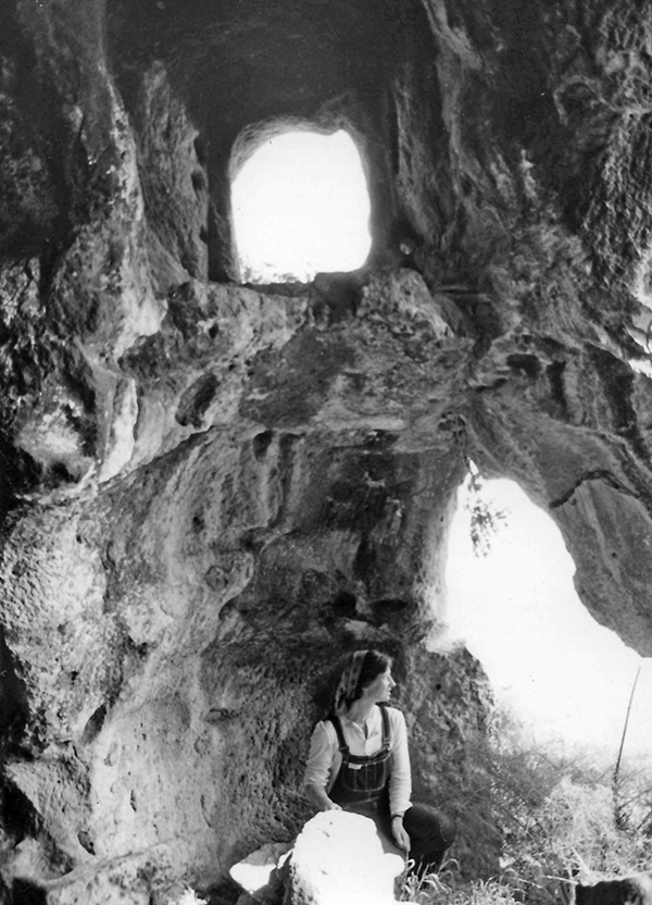
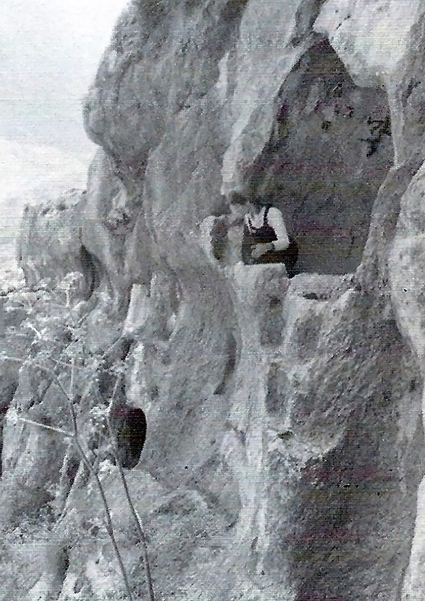
This reconstruction drawing shows the “Hanging Cave” complex on the southern bank of the Wadi Khureitun, which still bears the name of Chariton. The Cell of Chariton is located 15m (50 feet) above the entrance at ground level. Next to the entrance was a cistern. The cell could be reached by ladders via two lower caves. This section of the “Hanging Cave” monastic complex shows three different levels. The lower bell-shaped cave was reached from the valley by climbing some steps near the entrance. Using a 5m (15 feet) high ladder, the chapel on the middle floor was reached. From there, another ladder led to a small opening that led to the “Hanging Cell”.This drawing shows a monk climbing through a high opening in the chapel to a cliff-side channel that led to some steps by which the cell could be reached. Remains of fixings in the rock for a wooden door at the entrance to the cell, and the low remains of a stone wall facing the valley, indicate that the cell was protected from the elements.
We have fond memories of this Cave Church of St. Chariton in the stunningly beautiful Wadi Khureitun in the heart of the Judean Desert near the settlement of Tekoa.
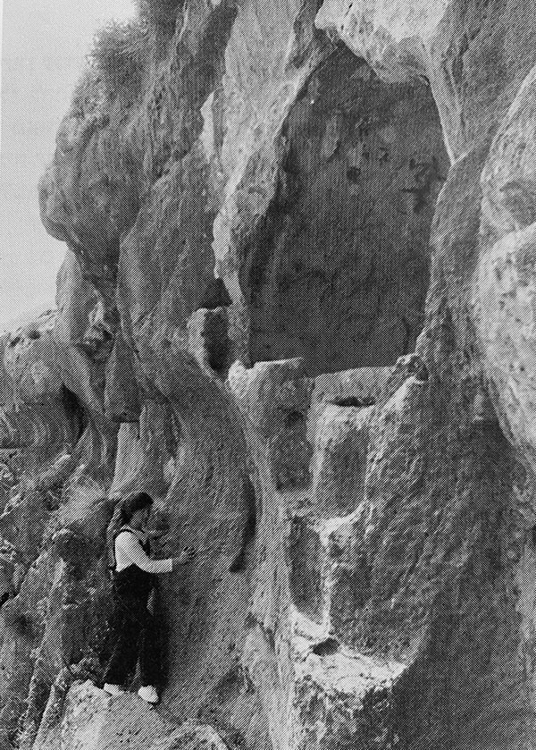
Leen in the Cell of Chariton on an earlier visit.
I had been there already with Yizhar, but I wanted to show Katia this amazing site and take further measurements to help illustrate his book The Judean Desert Monasteries in the Byzantine Period, Yale University press, New York, 1992, for which Katia did a lot of translation work. This is what she wrote about that memorable visit:
“Access to the Cell of St. Chariton was via an iron ladder of 5m in length bolted into the sides of a rocky mountain – quite an adventure! Here you overlook the ravine that at the time we visited was full of wild tulips. There were pine and eucalyptus trees in abundance with natural springs gushing through the cracks in the rock supplying the area with sparkling waters. Standing in the small space with its uneven walls and ceilings covered with soot, we saw how the cave was connected by low passageways to other caves. In these, monks ate, slept and prayed in the “laura” (hermit settlement), established by Chariton. He had originally come on a pilgrimage from Iconium and been abducted by robbers before settling in the Holy Land to establish monasteries.”
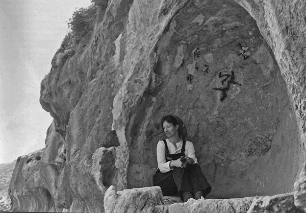
Katia in the chapel, waiting for a ladder to reach the opening above.Walking gingerly to the Cell of Chariton.Katia sitting inside the Cell of Chariton.Looking down at the 15m (50 feet) deep valley floor.
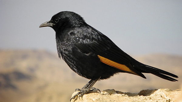
“The sight of the birds known as Tristram’s Grackle (with their iridescent black plumage and orange patches on their outer wing, and which are particularly noticeable in flight) diving down from the heights of the cliffs and sweeping upward just before they reach the bottom of the ravine, was incredibly beautiful.”
Tristram’s Grackle. Source: Wikipedia.
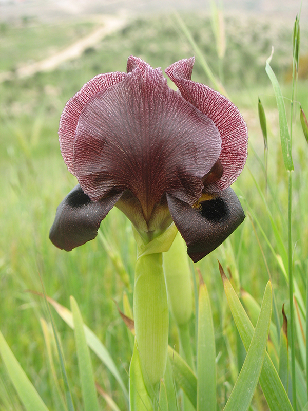
“The sight of some black desert irises that flower only occasionally in the desert, after a particularly wet winter, near Tekoa, was also very memorable.”
Black iris. Source: Wikipedia, shlomotm.Yizhar Hirschfeld and the monastery of Khirbet ed-Deir.
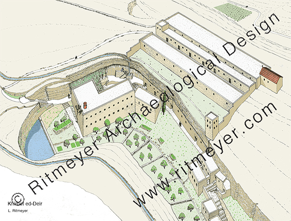
“That same year, we also made a wonderful family trip to Khirbet ed-Deir. Yizhar described it as “one of the most isolated and remote monastic sites of the Judean Desert … the location of the site in the heart of the desert and the excellent preservation of its remains leave a deep impression on the visitor.” It was located in the central part of the dry upper reaches of Nahal Arugot, about ten miles south of Bethlehem.”
The Monastery of Khirbet ed-Deir is located in a small ravine that branches off from Nahal Arugot, about 13km (8 miles) southeast of Tekoa, 16 km (10 miles) south of Bethlehem, and 27km (17 miles) south of Jerusalem.
“The monastery’s remains are built on a spur that rises above the riverbed’s south bank and along a gorge on the south side of the spur. Natural caves were incorporated into the monastery. It was basically a “cliff-side coenobium” where monks lived together as a commune.”
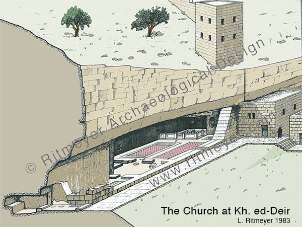
The Cave Church of Khirbet ed-Deir was built inside a large cave that was part of the monastery.
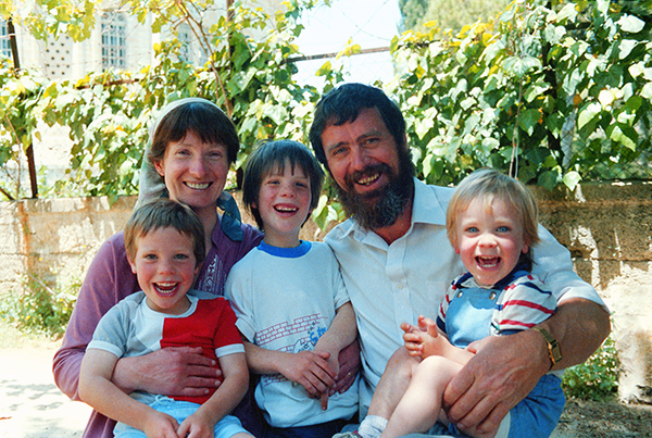
“While Leen was busy surveying the different parts of the monastery, we had been exploring the gorge and were getting out some drawing materials so that our children could record the visit.”
Our young family in Jerusalem.
“Suddenly, a group of Bedouin children appeared out of nowhere, wanting some of the equipment. I gave them some of our novelty pencils and rubbers and chatted with them, telling them what Leen and Yizhar were doing. They were amazed that we were bothering with a small site in the desert, but very pleased with their little gifts.”
“Yizhar was busy bringing out his book on the monasteries in the Judean Desert and we learnt a lot about them through his work. He lent us a book called The Desert a City: an introduction to the Study of Egyptian and Palestinian monasticism under the Christian Empire, by Derwas James Chitty (London, 1966), which, one writer said, was ‘full of brilliant passing insights and wonderful throwaway lines’ about the “City of the Wilderness.”
During our 22 years of work and exploring the Land we visited many memorable sites. Visiting these Byzantine monasteries in the Judean Desert, however, was a major highlight.
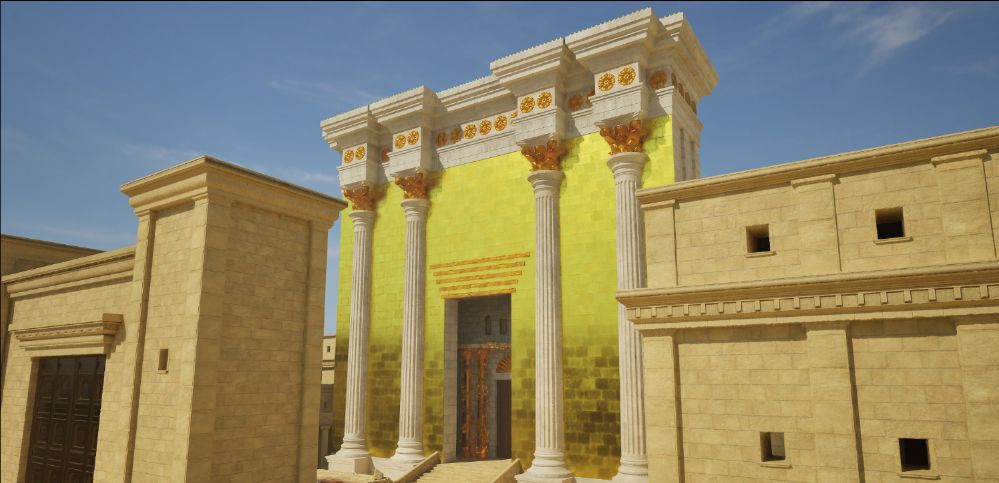
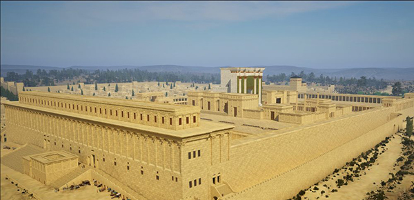
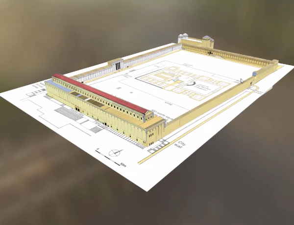
Jeremy Park of bible-scenes.com asked me a while ago if I could help him with his project of developing a 3D video of Herod’s Temple Mount. Last week he wrote the following:
“Shalom to you all. I am so excited to say that after almost two years working on this project it is finally finished; Herod’s Temple Mount. Journey back through time and see what Herod’s Crowning glory the Temple Mount could have looked like two thousand years ago. Places that we can see the remains of today, places like Robinsons Arch and Barclays Gate, Solomon’s Stables and the Western Wall, to name but a few.”
The compilation video can be seen here on YouTube.
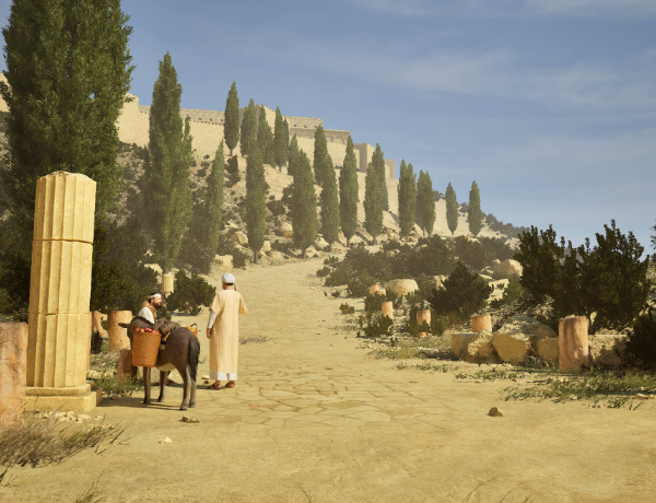
“When I made each scene I tried to include people. There were two reasons for this, firstly they gave a sense of proportion and scale as sometimes it is only when you see a person in the shot that you realise just how big some of the structures really are. Secondly, I tried to create a story of each scene where something is happening or has happened. For example, the picture of the two weary travellers on the road in the Kidron valley are obviously talking about the politics of the day:
Here are some additional images:
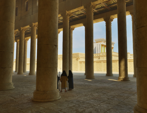
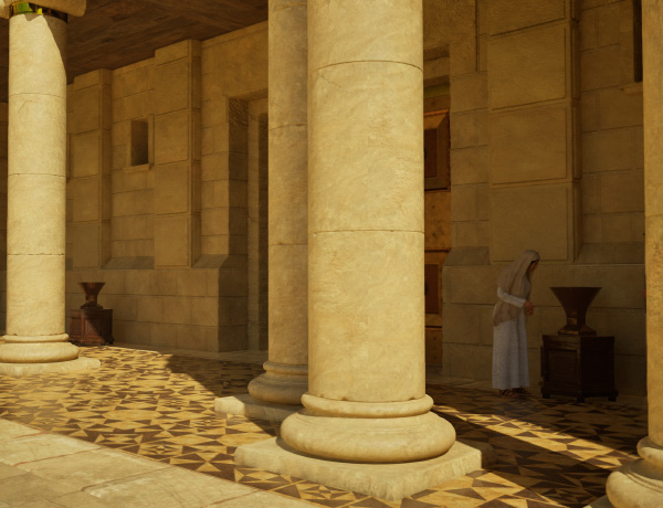
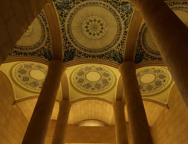
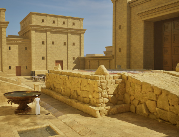
View of the Temple Mount from the southeastThe Temple, seen from inside the Royal StoaThe paving underneath the porticoes of the Court of the WomenThe domes inside the Double Gate passagewayThe altar was made of unhewn stones. According to Mishnah Middot 4:1, “The stones of the ramp and the stones of the Altar were alike taken from the Valley of Beth Kerem, where they were quarried from below virgin soil and brought from thence as whole stones upon which no tool of iron had been lifted up. For iron renders the stones invalid for the Altar even by a touch, and by blemish it renders them invalid in every respect.”
“As most of you are aware by now, I have followed Leen Ritmeyer’s model for this project and if anyone is interested in learning more about the Temple Mount, his book “The Quest” is a gold mine of information.”
“I was fortunate to discover the Ritmeyer Archaeological design Website where I was able to purchase comprehensive plans, elevations, images and information about all aspects of this incredible site that would have been the setting for many Gospel narratives. Without the Ritmeyer resource I don’t think I would have been able to have done justice to the historic and archaeological authenticity of the site.”
This shows how Jeremy used my plan of the Temple Mount to start his design
I am probably a little biased when I say that this is the best 3D rendition of the Temple Mount I have seen so far.
Do watch the video and let Jeremy Park know what you think. He would love to hear from you. His HD videos are free to watch and download, but only subscribers can download high-resolution 4K copies:
The High Definition (HD) videos on this site are free to download and are accessed from the HD download buttons that accompany each scene.
4K videos are available to all subscribers.
When anyone subscribes, an e-mail will be sent out with the necessary password enclosed.
Jeremy’s Bible Scenes is not a separate charity but a branch of his company Park 3D Ltd. Until Bible Scenes can provide him with a sufficient income to work full time on it he has, by neccessity, a day job. He would love to have your support!
What comes next?
“Over the next few days I will be uploading each camera move that you see in this video in HD and 4K to the Bible Scenes Website. As subscribers you will have access to these videos 4 weeks before they are released to the general public (and of course access to them in 4K). I will let you know as soon as the website is updated with the new videos. After this I will be concentrating on producing individual descriptive videos of most (if not all) of the elements that make up the Temple Mount. For example, there are 18 chambers that surround the Temple itself, all of which serve a different purpose and while I may not be including all of them, I think there is a wealth of information to share regarding them. Then there are the various entrances and gates, the Royal Stoa, the Antonia Fortress and all the other parts that make up this project, all have their own story. I am excited to start producing them and will let you know as soon as they are completed.”
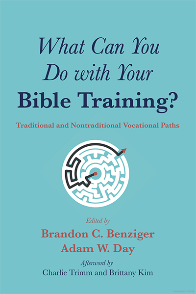
I am guessing that some, if not all, of the readers of my blog may be interested to see the latest book[1] to which I had been asked to contribute.
The authors, Brandon Benzinger and Adam Day, are to be commended to have tackled the problem of finding jobs for graduates of Biblical and Theological Study programs. As fewer and fewer jobs are available to them, the editors understood that to get employment, these candidates must think outside the box.
They asked 25 people who have found satisfying jobs to share their experience of how they settled into their present occupation, the ways in which they have used their biblical training in that occupation, the “joys” and “trials” of their work, and advice for those who would like to follow in their footsteps.
The book is divided into four parts:
Part 1: Academia
Part 2: Publishing and Media
Part 3: Congregational Ministry
Part 4: Parachurch Ministry, Missions, and Public Service
I would love to have had this book available at the beginning of my career, rather than nearer the end of it.
Personally, I can’t wait to read the contributions of Steve Ortiz and Mark Wilson, who are closest to my field of work, but I think that I will be quite amazed how interesting I will find many of the characters whose professional dreams are portrayed here.
My chapter in Part 2 is called “Design and Illustration”, in which I set out the various roads I have followed and to see how biblical studies can be a springboard to not just one but possibly a few different careers.
It is interesting to note that those who show the highest level of satisfaction are those with supportive familes.
Personally, I am very thankful that my work has also brought me many joys, chiefly in that I have been able to share it with my wife Kathleen, a trained archaeologist. Her excellent writing and research skills have enabled us to produce books and various other educational materials that people still find useful today. When my family was young, I was often able to take them on digs and give them some memorable experience. When they were older, they helped me at times with photography, cartography, and illustration.
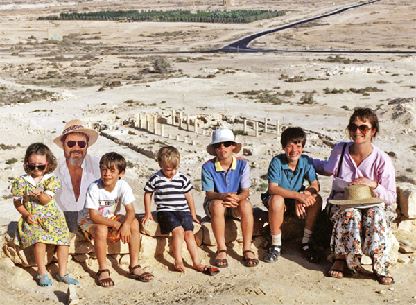
Our young family at the Tel Nitzana Excavations in the Negev on the border of the Sinai desert
And, of course, some of the most exciting moments in my career were the making of major discoveries, such as the placement of the ark of the covenant on the Temple Mount, the identification of the Middle Gate mentioned in Jeremiah 39:3, and the main gate of Sodom, where Lot sat (Gen. 19:1).
I warmly recommend this book to all those seeking alternative employment in this ever shrinking field.
[1] Brandon C. Benzinger and Adam W, Day, editors, What CanYou Do with Your Bible Training? Traditional and Nontraditional Vocational Paths, Resource Publications, Eugene OR, 2023.
In our previous blog, we looked at the Middle Gate as an example of the description in Lamentations 2:9 that Jerusalem’s “gates were sunk into the ground.” We published it on the 1st of September, as that was one of the readings for the day according to the Traditional Daily Reading plan of the Avery Bible app.
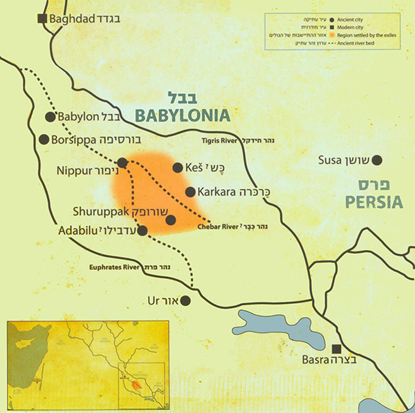
Today, on the 5th of September, according to this plan, we begin reading the Prophecy of Ezekiel. From Chapter 1 we understand that Jehoachin, King of Judah, was exiled to Babylon along with Ezekiel and several thousands of Jerusalem’s leading citizens.
According to Ezra 2:59, the Jews lived in villages like Tel Abib, Tel Melah, Tel Harsha, Cherub, Addan, Immer and Casiphia, from where they returned following the Edict of Cyrus in 539 BC. The location of these places is not known, but it is understood that these were clustered round the River Chebar, where the Jews were forced to work on government projects.
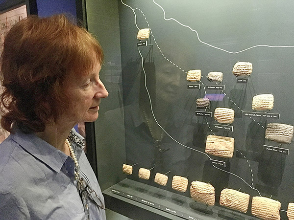
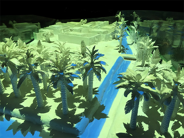
A few years ago, in 2017, as part of an archaeological project we were doing in the area, we visited the Bible Lands Museum in Jerusalem. At that time, the curators had put on a dazzling display called “Jerusalem in Babylon”, showing archaeological evidence for some of the places where the exiles lived. This was the first time that archaeology had proved that Jews lived here during the Exile. The following images are photographs taken by permission of the Bible Lands Museum.
The orange tinted area indicates where the exiles were settled.
While reminiscing recently about the highlights of our archaeological careers, we could not help but include our visit to this exhibition as a stand-out experience.
We had assumed that this was only a temporary exhibition and expected it to be dismantled. We were pleasantly surprised, however, to see on their website that this exhibition is still very much on!
An animated movie in Hebrew (but with English subtitles) introduces the story of the Exile for children. We were indeed relieved to see that this unforgettable exhibition could still be enjoyed by the next generation.
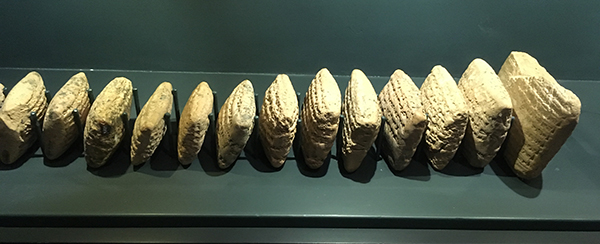
These are some of the inscribed clay tablets that mention the places where the exiles lived. Kathleen examining a vitrine in which several clay tablets are displayed.
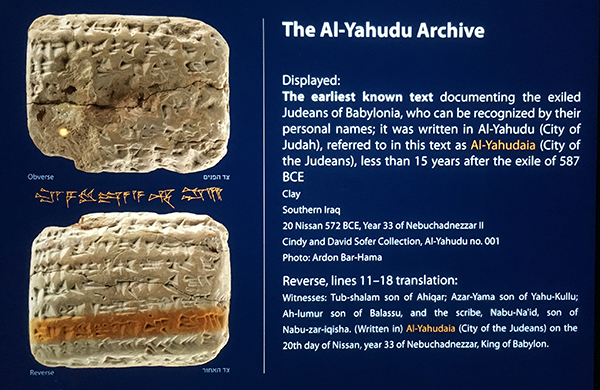
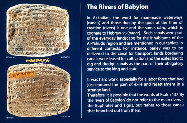
The text on some of the clay tablets that were discovered showed that the exiles lived in an area called Al-Yahuda (City of Judah) or Al-Yahudaiah (City of the Judeans), where they were initially forced to dig and dredge canals for transportation of goods as part of their obligatory service to the king and state.
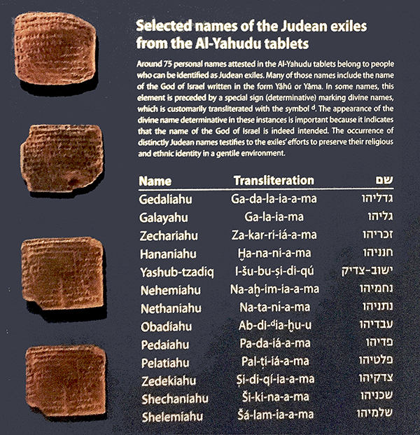
Some clearly recognisable Jewish names, such as Gedaliah, Zechariah, Hananiah, Nethanyahu, Obadiah and Zedekiah, have been found on several of these tablets.
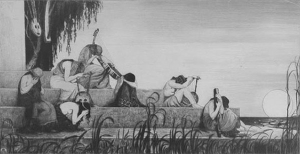
“On the Rivers of Babylon” (1910), by Ephraim Moshe (Moses) Lilien, an Austro-Hungarian art nouveau illustrator and a member of the Zionist movement. The people on this etching are mourning next to a large river.
The Akkadian word for man-made canals (naru, Hebrew nahar) is one and the same for rivers. Therefore, it is possible that the words in Psalm 137:1, “By the rivers of Babylon there we sat down, yea we wept when we remembered Zion”, do not refer to the main rivers, the Euphrates and Tigris, but rather to those canals that branched out from them, which the Jewish captives were forced to dig. It was hard work, especially for a labour force that had just survived the destruction of their country and a long march from Judah to Babylon. These canals were needed to bring water for irrigation purposes and for bringing goods to inland cities, such as Babylon.
When that work was completed, the Jews were allowed to settle in the land.
This illuminated model gives an impression of the houses in which the exiles lived, next to a hand-dug canal. This tablet contains evidence for the man-made canals that the exiles were forced to dig.
The text on these tablets also showed that after an initial hard time, the Jews quickly settled down and became prosperous. Some preferred to stay in Babylon rather than to endure the hardship of pioneering work in the province of Judea.
However, after 70 years, many exiles that had been living in Babylon since the conquest of Judah by Nebuchadnezzar, returned from Babylon to Jerusalem and Judea.
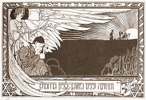
At the end of the 19th century, Jews again, after a much longer exile, returned to the Land of Israel, and many saw a historical parallel with the return of the exiles from Babylon.
This engraving by Ephraim Moses Lilien was printed on the invitation for the 5th Zionist Congress, held in 1901, as stated in Hebrew at the top of the drawing. The pogroms in Russia and Eastern Europe at that time stimulated Jewish immigration to Palestine. This ideal has profound religious and historical roots, one of which was the return to Zion after the Babylonian exile.
The lower Hebrew inscription reads: “May our eyes behold your return in mercy to Zion.”
“her gates have sunk into the ground.” (Lamentations 2:9)
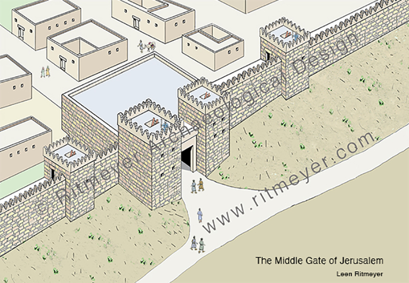
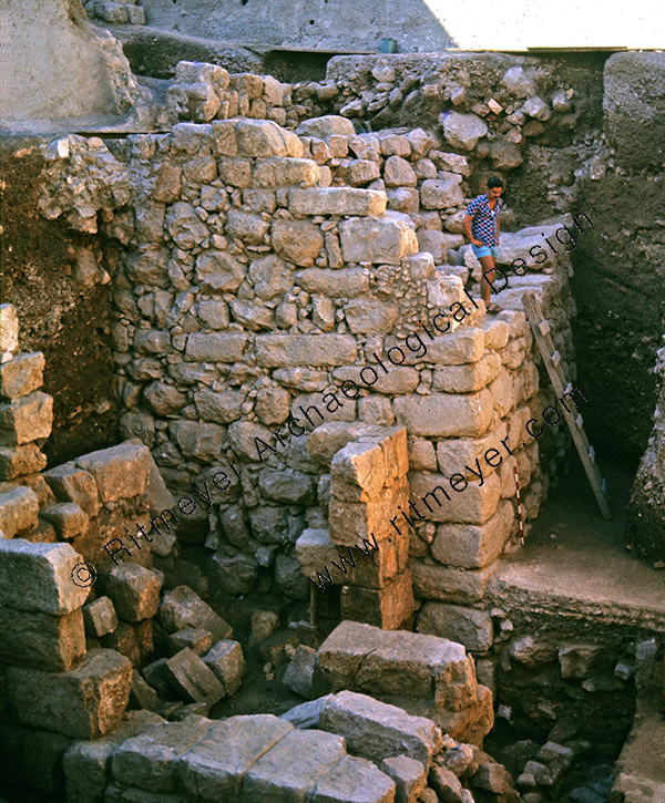
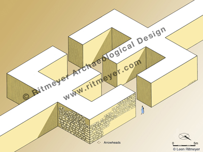
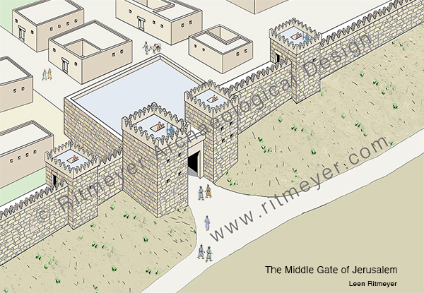
The Middle Gate is mentioned in Jeremiah 39.3 as the place where the Babylonian princes came together to celebrate their conquest of Jerusalem. The destruction of Jerusalem was dramatically exposed in the excavations in the Jewish Quarter of the Old City of Jerusalem that were directed by the late Prof. Nahman Avigad. After digging down for some 10 m., a large L-shaped fortified wall of the Israelite period was found.
Here we see the corner of a large L-shaped fortified gate that was excavated in the Jewish Quarter of the Old City of Jerusalem.
This gate was called the Middle Gate as it was built in the middle of the northern wall of Jerusalem of that time. It is amazing to think that the Babylonian princes, who sat in the Middle Gate, Nergal-Sharezer, Samgar-Nebo, Sar-Sechim, Rab-Saris, Nergal-Sharezer and Rab-Mag, all came from what is now known as Iraq.
A partial reconstruction of the excavated remains of the Middle Gate.
Jeremiah witnessed and lamented the Babylonian destruction of Jerusalem in 586 BC. “O wall of the daughter of Zion, let tears run down like a river day and night; give yourself no relief; give your eyes no rest” (Lamentations 2:18).
In Lamentations 2:9, we read that “her gates have sunk into the ground.” As all large buildings in Jerusalem, including the gates, were built on the bedrock, these gates could not have sunk deeper into the bedrock on which they were built.
However, there is a logical explanation for this description. The Today’s English Version (formerly the Good News Bible) paraphrases this verse as, “the gates are buried in rubble”. After the destruction, rubble and destruction debris would have accumulated around the destroyed gate and raised the ground level around it, so that the preserved top would have been barely visible. This would have given the impression that the gates had sunk into the ground.
It is exciting to find the remains of buildings that are mentioned in the Hebrew Bible, but also sad to reflect on the terrible destruction that took place some two and a half thousand years ago.
Fifty years ago today, I embarked on a career which previously I hadn’t know existed and couldn’t have dreamed up for myself. It combined the disciplines of archaeology, ancient architecture, history, education, and Biblical Studies. Since realising, a few years later, that this would require the wearing of multiple hats, (although my fedora was the one that was most practical and the one that became identified with me), I got used to various titles like: “Archaeological Architect”,“Conservator” and “Lecturer”. However, I soon learnt that the hat of Bible Student was the most valuable, and that which could encompass most of my interests. My studies of the Bible had taught me core skills that could be useful in many situations. Research, analysis, interpretation, and application, to mention but a few, all could be improved and enhanced by immersion in the Good Book.
A few months ago, one of my sons, Ben, was looking at a book that contained drawings of cities from Biblical times with one of his sons, Seth ( my now 5-year-old grandson). Ben mentioned that some of these sites were thousands of years old. Seth exclaimed: “as old as Grandad!” Now, I do not claim to be thousands of years old.
Grandson Seth at my computer desk
But when I looked around my workroom/studio in the cottage we now live in South Wales, I realised that within its walls lie physical evidence of 50 years of visualising the Bible. Its main holding is a substantial library of volumes that contains many of my reconstruction drawings. Some of the most well-known are Study Bibles and our own books, most of which have been published by Carta of Jerusalem. There are traditional dig reports and guide books too. And, added later, also items of a more unusual shape, like CDs and DVDs.
So – if this turning of the year makes you feel like hearing the story of Ritmeyer Archaeological Design, gather round and I will try my best to tell it. And for those of you who on occasion have asked: “How can we learn to do what you do?”, you may pick up some hints or feel that you have had your fill already.
A Dutchman, I graduated in 1967 with a degree in Physical Education from Arnhem. At that time there was compulsory military service, and within a week all my friends had been enlisted, but I was the only one not called up. As I could not commit myself to at least one year of teaching, I decided to go and travel until the military call-up arrived.
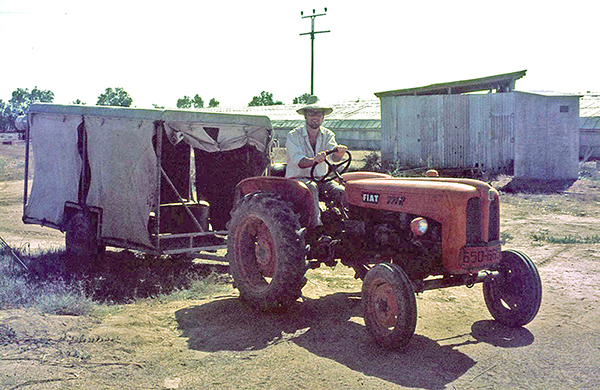
After the Six-Day War, there was a shortage of manpower in Israel, as most men were still mobilised. So, I volunteered in Kibbutz Yad Mordechai near the Gaza Strip and stayed there for almost half a year. I used my free time to travel through the Land, began to read the Bible and learnt Biblical Hebrew. The combination of knowing the geography of the Land and learning Hebrew greatly increased my understanding of the Scriptures and developed in me a love for the Land that only got stronger over time and never left me.
Driving a tractor at Kibbutz Yad Mordechai
In 1969, I decided to try and settle in Israel, which as a non-Jew was not easy, but I eventually found work on the Temple Mount Excavations under the direction of the late Prof. Benjamin Mazar (1906-1995). Before finding this position, I had written a letter to David Ben-Gurion, the former Prime Minister of Israel and was granted permission to stay as a temporary resident. I held this status in fact, for twenty years – a permanent temporary resident!
And reflecting on the way I had originally found the job on the Temple Mount Excavations, it also seemed pretty fortuitous. In 1972, I had read a report about the Temple Mount Excavations in which they appealed for more staff. My late sister Martha had got a job illustrating ancient architectural elements when she applied. She did very well at this work, which she liked very much. We decided to move from the area of Petach Tiqva (Door of Hope), the area where we had been living and earning a livelihood, and we found a house in Bethany near Jerusalem.
My late sister Martha drawing one of the domes in the Double Gate passageway
After hearing from Martha that I was also looking for work, the deputy director of the dig, Meir Ben-Dov, asked me to come and work there too. I was not too enamoured when I saw the dig with its broken stones and walls and volunteers slaving away in the dust and heat. He offered me the job of drawing potsherds in a tiny room that was a converted cupboard. I ran away as fast as I could! However, he persisted and eventually offered me the job of surveyor. I had never done anything like that but replied that I knew where the zero on the tape measure was and was ready to give it a go.
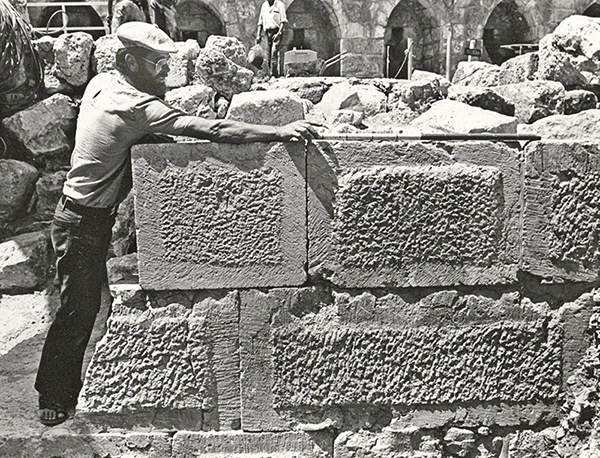
Surveying an ancient wall
So, on the 1st of January 1973 I started to work as the dig’s surveyor, making plans on a scale of 1:50. An Irish architect, Brian Lalor, later to achieve renown in his own country in the field of printmaking, trained me in and I liked the work. When I showed him my drawings, I observed what he did with them. He reduced my plans and then completed broken or missing walls and reconstructed elevations and then made complete reconstruction drawings of the building remains that I had surveyed. I thought this was fantastic and, seeing that I was interested, Brian gave me a Byzantine bath house to reconstruct, a work that quickly drew me in.
The great joy in archaeological excavations is figuring out how architectural structures worked. A couple of months later I was asked to survey the Herodian shops to the east of the Triple Gate. These shops were at a much lower level than the street in front of this gate. It was obvious to me that the roof of these shops must have supported the street above. I asked Brian what kind of roofs they might have been, but the response was unclear. One morning, when the sun was shining at just the right angle, I looked up and saw the burnt imprints of arches in the Southern Wall of the Temple Mount and figured out that the descending stepped street above must have been built over the vaulted ceilings of these shops. The shops had been burnt down by the Romans in 70AD, but before the vaults collapsed, the fire burnt into the Temple Mount wall, leaving the imprints of the vaults as an evocative testimony to this dreadful inferno!
The burnt imprint of the vault closest to the Triple Gate
My theory at first was greeted with unbelief, but when Prof. Mazar and Brian came to have a look, they were bowled over when they saw the actual evidence. The difference in height between these vaults was 60 cm (2 feet). This corresponded to the height of three steps. And so, it was possible to make a watertight reconstruction of the street above the shops. The excitement and thrill of this discovery got me hooked on ancient architecture for life.
The difference in height between the burnt arches corresponded to three Herodian steps.
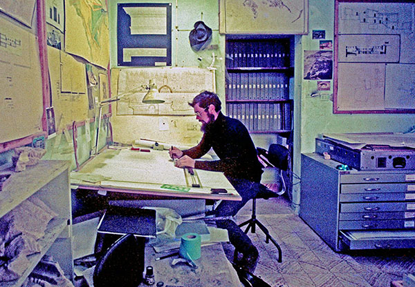
Four months later, Brian left to return to Ireland, and Benjamin Mazar told me to sit in the architect’s chair and to continue supervising a small team of volunteer surveyors that I had trained in. I was left in charge of the architect’s office, and that is how my career as an archaeological architect took off. During the winter months of 1973, Mazar sent me to the library of the Rockefeller Museum to study ancient architecture under his personal guidance.
In the architect’s office
The making of reconstruction drawings, that became my speciality, was born out of necessity. Apart from my regular architectural work, some staff members including myself, gave tours to other archaeologists and visitors. It was this experience that convinced me of the necessity for these drawings. One of the first stops on the tour was Robinson’s Arch, one of the four gates in the Western Wall of the Herodian Temple Mount. I tried to explain the features of the arched staircase that led up to the Temple Mount from the street below, sometimes using my hands and feet. From questions I received afterward, I realized that not everybody could visualize how it worked. I then made my first reconstruction drawing of Robinson’s Arch. On this drawing, I indicated in color the visible remains and drew the reconstruction in black and white lines. This visual connection with the archaeological remains made the reconstruction immediately recognizable. Seeing people’s faces change from incomprehension to clear understanding assured me that this was the way to go.
Reconstruction drawing of Robinson’s Arch
Eventually, my reconstruction drawing of the Temple Mount that was used by many guides, became a classic and has been published in many books.
During the Yom Kippur war in October 1973, Israel captured large areas of Syria from Kuneitra to halfway down to Damascus. This area was referred to as the Bashan. After the fighting was over, the soldiers who were archaeologists went back to their normal Unit for the Knowledge of the Country. They had to do an archaeological survey of the Bashan and found two-story Roman houses that had recently been lived in still standing up.
As the archaeologists couldn’t make architectural plans, I was employed by the Israel Defence Forces (IDF) to join this unit. This was very exciting, as this was my first visit to Syria and I got to know all the up-and-coming young archaeologists, such as Amihai Mazar, Dan Urman, Zvi Ilan and Amos Kloner.
A Roman house at Kafr Nasj in the Bashan
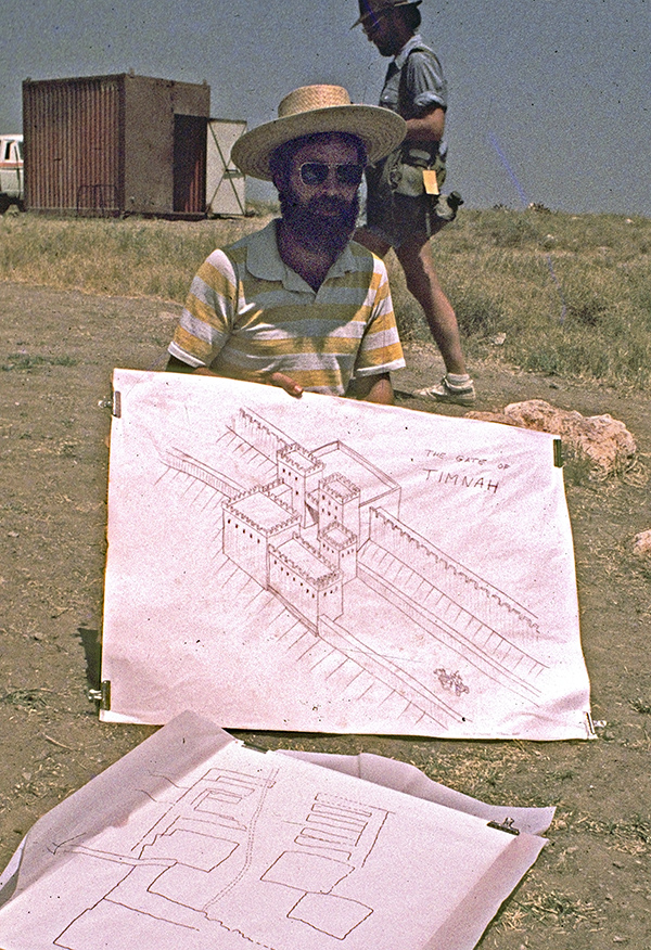
Later, some of this group asked me to make drawings for them. Amihai employed me to draw up the plans of the Tel Qasile excavations and later asked me to join the Tel Batash (Timnah of the Philistines) dig, Dan Urman asked me to join the Tel Nitzana excavations and draw up the plans of Rafid on the Golan, Zvi Ilan asked me to make a reconstruction drawing of the Byzantine Synagogue that he had excavated in Meroth, and for Amos Kloner I drew up some of the caves of Bet Guvrin.
Reconstruction drawing of the Gate of Timnah
Back at the Temple Mount excavations, I finalised the survey plans, and made reconstruction and publication drawings of buildings belonging to different periods. Prof. Benjamin Mazar was interested in the Herodian and earlier periods, while Meir Ben Dov was given responsibility for the later periods. From my office room I could see who was coming down the steps to see me. When Mazar came down, I quickly put the Herodian drawings on my desk and exchanged them for later period drawings when Ben Dov was visiting!
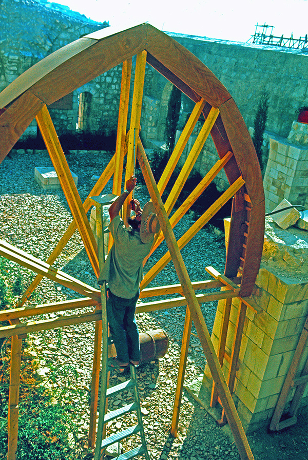
Another chapter in my career opened when I was asked to reconstruct the Crusader Church of Saint Mary of the Germans in Jerusalem. This work involved the building of a staircase and the pillars that once supported the vaults of the hospital hall of the hospice complex in the Jewish Quarter of the Old City. To make the pointed arches, I cut templates out of carton for the individual arch stones on the flat roof of our house in Melchizedek Street and gave those to masons in Bethlehem who cut the stones and built the arches.
Inspecting the wooden centering – a temporary frame to support an arch or vault during construction
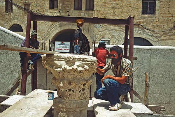
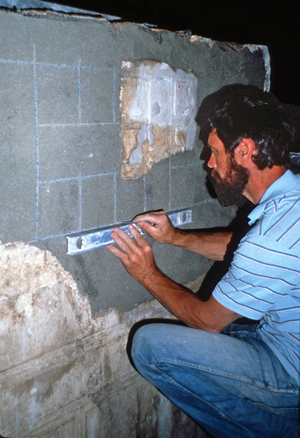
It was the first of several restoration projects I later became involved in, eg the Byzantine Cardo and the Herodian villas in the Jewish Quarter of the Old City of Jerusalem. Restoration consists of consolidating the actual remains to prevent deterioration. At times, it is important to reconstruct parts of the ancient ruins. This is extremely sensitive work. It is very important not to build up the site too much, but to do it so that one gets a real feeling for how it would have looked originally.
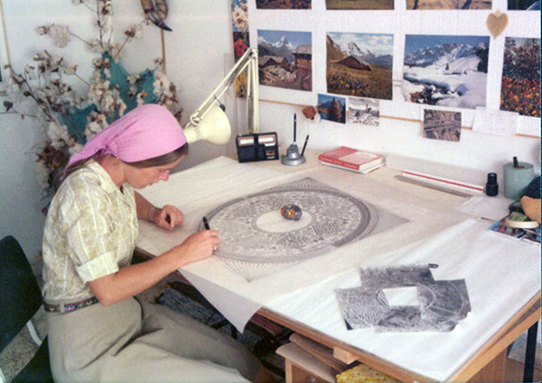
My life changed in 1975, when Kathleen, an Irish archaeologist, came to work on the Temple Mount Excavations. I still remember her joining the tour I was giving on the dig at the southwest corner, but had no idea that eventually she was to become my beloved wife. She was certainly the best find ever!
Kathleen at left using my Temple Mount reconstruction drawing during a guided tour
In 1983, Kathleen and I established a partnership called Ritmeyer Archaeological Design (RAD), which is an independent partnership devoted to archaeological reconstruction and the production of educational materials, and it is still active today. Kathleen’s excellent writing and research skills enabled us to produce books and varied educational materials that people still find useful today. Just as much as I like drawing lines on paper, she says that she loves to “push words around the page!” Working together has been a great blessing, as we have similar interests and complement each other.
Much of my time in Israel then involved the restoration, first of the Byzantine Cardo and the Herodian Quarter in the Jewish Quarter of the Old City, later called the Wohl Museum.
Checking the position of a capital during the restoration of the Byzantine Cardo.Drawing the design of the stucco decoration in the Reception Room of the Palace of Annas the High Priest.
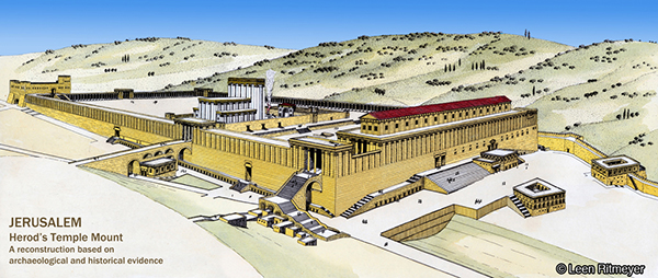
In 1989 we moved to England, and even though we no longer had a Jerusalem address, the projects kept coming in. One of the largest such projects was the design of models of the Tabernacle, Solomon’s Temple, and Herod’s Temple and Temple Mount for a Jewish philanthropist in Washington, DC. Photographs of these models, beautifully crafted by York Model Making, are included in RAD’s Image Library.
Model of Herod’s Temple Mount
Other projects I’ve worked on in recent years, include mapping every journey in the Bible and illustrating as many as these mappable events as possible for the United Bible Societies’ Augmented Reality Bible. And even more recently, I’ve collaborated on a voice-driven VR experience, in which a VR headset allows one to walk through a city or large building in a specific period. The first project we worked on focused on Capernaum. I provided all the archaeological and historical background, whereas other artists made the relevant 3D-enabled drawings and computer experts developed the technology.
Our Temple Mount guide book was published in 2016
My work has also brought many rewards for our family life. When our children were young, I was often able to take them on digs and give them memorable experiences that they still talk about today. When they were older, they helped me at times with photography, cartography, and illustration.
If you were to ask me what were some of the most exciting moments in my career, I would say they would be the making of major discoveries, such as the location of the Holy of Holies of Solomon’s Temple and the emplacement of the Ark of the Covenant, and the identification of the Middle Gate mentioned in Jeremiah 39:3. The latter made it possible to relive, as it were, the destruction of Jerusalem by the Babylonians. Arrowheads found among the charred timber and ashes at the base of the tower point to a fierce battle around the city walls of Jerusalem in the time of Zedekiah. Our hands got black with soot—tragic evidence of the fall of Jerusalem.
And for those brave ‘wannabes’ who would like to follow my footsteps, all I would say is: listen to your heart, find an encouraging mentor, and watch how he/she does things on a site you love in the Land. Make yourself as indispensable as possible and make reading the Word in the ruins your inspiration.