In the Jan/Feb 2009 issue of Biblical Archaeology Review, an article was published by Ehud Netzer, called “A New Reconstruction of Paul’s Prison”. Netzer is a respected and successful architect/archaeologist and well-known for his excavations of Herodium and Hasmonean and Herodian Jericho and other Herodian sites. Recently he amazingly found the long-lost tomb of Herod the Great.
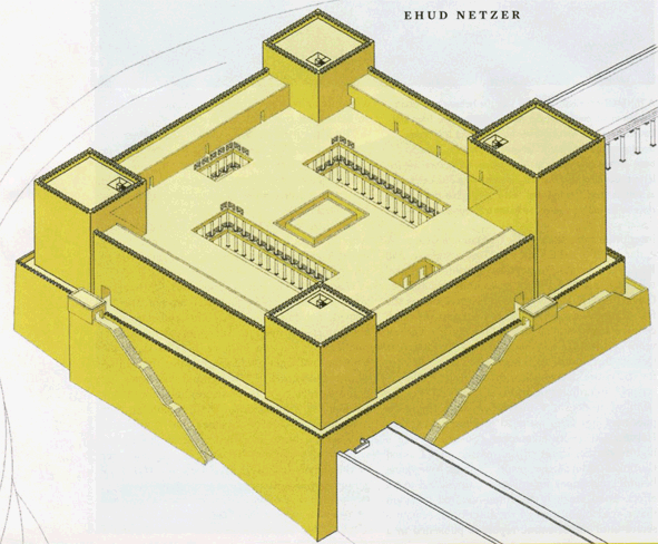
In the last few years he also tried, less successfully in my opinion, to reconstruct Herod’s Temple Mount. His reconstruction proposal for the Antonia Fortress is a clear example of ignoring important historical sources and archaeological evidence. Here is his reconstruction:
As far as historical sources are concerned, Josephus (War 5.238-246) wrote that “The tower of Antonia lay at an angle where two porticoes, the western and the northern, of the first court of the Temple met; it was built on a rock fifty cubits high and on all sides precipitous.”
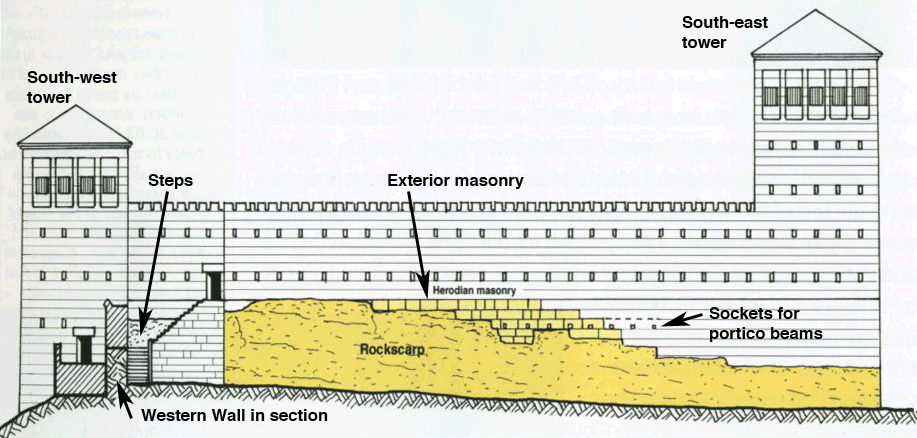
The reconstruction of Netzer does not meet these two historical requirements. The northern and western porticoes don’t meet and no rockscarp is to be seen in Netzer’s drawing on the south and west sides. Indeed, there never were precipitous rockscarps in the area occupied by the southern and south-eastern part of his reconstruction.
There is archaeological evidence that the two porticoes did in fact meet. Sockets for the roof beams of the northern portico can still be seen today in the northwest corner of the Temple Mount, see Ritmeyer, The Quest, Revealing the Temple Mount in Jerusalem, p. 130), see:

These sockets were placed in exterior Herodian masonry, which is visible high above the still-existing rockscarp. This masonry consists of ashlars with the typical Herodian margins, which were used for exterior masonry only. This proves that this rockscarp with its Herodian masonry was an external wall, namely the southern wall of the Antonia Fortress and not an interior wall. This also shows that the northern portico of the Herodian Temple Mount ran in front of the southern facade of the fortress, enabling it to “meet” with the western portico, as described by Josephus.
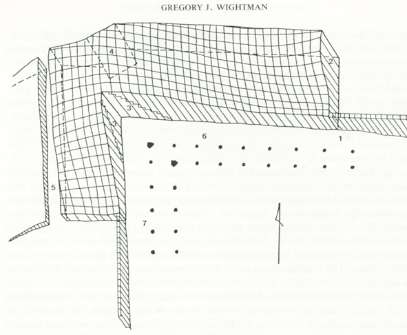
Netzer places the south-western corner of the fortress at small projection in the Western Wall. This projection exists, possibly because of the lay of the bedrock, but it is too insignificant a projection for the south-west tower of the Antonia. There is a much larger projection to the north, which is completely ignored by Netzer. It can be seen in the western side of the north-west corner of the Temple Mount and at the end of the Western Wall Tunnel. This projection has been mapped by Gregory Wightman (Temple Fortresses in Jerusalem, BAIAS, Vol. 10, pp. 7-35) in this diagram:

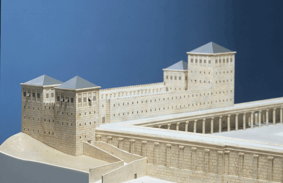
It shows that the south-west tower projected much more from the Western Wall than shown in Netzer’s reconstruction. All of these historical and archaeological data, ignored by Netzer, have been incorporated into my own reconstruction of the Antonia Fortress as shown in this model:

Original Herodian paving stones were, until recently, visible in the north-west corner of the Temple Mount. Netzer’s reconstruction does not relate to this pavement. Netzer’s Antonia plan is square, although the north-west corner of the Temple Mount is in fact not a right angle, but an acute angle of approximately 86 degrees.
In 1975, P. Benoit (The Archaeological Reconstruction of the Antonia Fortress, Jerusalem Revealed, 1976) has brilliantly shown that the Antonia was located exclusively on the rockscarp at the north-west corner of the Temple Mount. Prior to this time, several scholars, such as De Vogüé and Vincent, had promoted a larger Antonia which projected inside the Temple Mount. It is a pity to see that Netzer has regressed to that earlier and by now obsolete reconstruction of the Antonia Fortress.

Hi Professor Ritmeyer, Thanks for your very detailed explanation. I hope Professor Netzer acknowledges your findings. Warm Regards.
The problem with your plan is the distance between the north-west corner of the Temple Mount and the Striation Pool. This distance is 25 m. You place there two towers. One would be enough. Herod expanded Bira which was built by Hashmonians (Antiq. 18, 403). I think that their Bira was at the north-west corner of the Temple Mount, opposite to a tower at the north-east corner of the Temple Mount. This tower would fit the protrusion in the wall which is 25 meters from south to north. This would make the Hashmonian Bira 25 meters from south to north. Hordus added 25 meters to the north. Hence the expanded Antonia was 50 m from south to north and 100 m from west to east (till the end of the scarp). As you correctly observed, the original Bira was at the north west corner of the upper platform. You identified the lower step there as the western border of this Bira. The Golden Gate was a counterpart of the Bira. On its roof was the Stone Chamber where the High Priest was sitting 7 days before burning the red cow. Hence, this gate was called the gate of Cohen. According to Midrash of Song of Songs, two gates survived the destruction till the very end- the Hilda gate (this is the Double Gate) and the gate of Cohen. Indeed both are intact and are very similar in design. There is much more to it but I will stop here. See the map http://truthofland.co.il/english/images/templemountcom.gif
Daniel,
You and I may think that one tower was enough, but Josephus wrote that the Herodian Antonia had four towers at each corner (War 5.238-246). I placed the southwest tower above the rockscarp at the end of the Western Wall, which can be seen inside the Temple Mount.
I have written that the early Antonia which replaced the Hasmonean Baris stood at the northwest corner of the 500 cubit square pre-Herodian Temple Mount, which indeed had a counterpart in the northeast tower mentioned as the “aliyat hapina” in Neh. 3.31.
The Double and Triple Gates are mistakenly identified as the Huldah Gates. The real Huldah Gates are mentioned only in Mishnah Middot and refer to the southern gates in the pre-Herodian square Temple Mount. The historical names of the Herodian Double and Triple are not known.
I just learned that Herod had a fotress built and named it Antonia which is my given first name.
The info I received states it was the fortress that Herod proclaimed Christs death.
I am impressed that my given name goes back to the biblical days even though I am not a follower of the bible. I was also told the fortress was the place where Herod proclaimed the crucifiction of Christ.
My parents purpose to name me Antonia was not to follow the Italian tradition to name a daughter Antoinette and I was born on a catholic saints day, Anthony. Now I have learned the history of my name. Wonder if my parents new of the Fortress Antonia.
Antonia,
Herod indeed built a fortress at the northwest corner of the Temple Mount. Christ was condemned to death by Pilate, who resided in Herod’s Palace in the west of the city.
What is the architectural relationship between the convent of the daughters of Sion, whose convent is said to occupy an area of the the Antonia Fortress, and the fortress itself ? On a visit, I saw for myself the purported lithotstrotos,where Roman soldiers played dice; and on which Christ is reputed to have walked on the Via Dolorosa. It appears from the illustrations and conjectural restorations, that the Antonia was
much larger than I had realized: but this is understandable, if the Roman garrison
was 600 strong. It could also illustrate the concern of the Roman authorities regarding the Temple site, as the volatile epicentre of Roman Palestine.
Peter,
The lithostrotos was a pavement built in around 135 A.D. on top of the two vaults that covered the Strouthion Pool. It has nothing to do with the time of Christ. Archaeological evidence points to the high rockscarp, on which now the Ummariya School is located, as the location of the Antonia Fortress.
When I read the books of Josephus, I finde that the Temple Mount area was smaller then today, that the Temple Mount enclosure included a Roman fort, that the Temple area wasn’t four-square because of the Roman fortress located in the northwest corner of the Temple Mount, that the two porticoes (cloisters) of the Tempel court did not meet at the northwest corner because of a Roman fortress located in the northwest corner of the Temple Mount , that the Roman Fort was four-square with four towers, and so forth …
Josephus wrote that “The inward parts [of the Roman fort] had the largeness and form of a palace, it being parted into all kinds of rooms and other conveniences, such as courts, and places for bathing, and broad spaces for camps; insomuch that, by having all conveniences that cities wanted, it might seem to be composed of several cities, but by its magnificence it seemed a palace” (The Wars Of The Jews Book V)
Therefore I am also convinced that this Roman fort in Jerusalem, like all other Roman forts in the Roman Empire, had a Commandant’s House (praetorium), where the Temple priests brought Jesus Christ to be judged by the praetorian prefect (Pontius Pilate)
Ove,
The pre-Herodian Temple Mount was square and smaller indeed, but Herod’s additions to the north, west and south gave the Temple Mount the dimensions it has now.
The Antonia Fortress stood at the northwest corner, but archaeological remains have proved that the northern portico ran in front of the fortress and so could meet up with the western one, exactly as Josephus wrote. The Antonia was very large indeed as it encompassed and area to its north.
The preatorium was housed in the Antonia during the time of King Herod, but after his death the Roman procurators took over Herod’s Palace and used it for their residence when in Jerusalem. It was there that Jesus was brought before Pilate.For further information, please read my book The Quest: https://www.ritmeyer.com/online-store/books/the-quest-revealing-the-temple-mount-in-jerusalem/
¿What do you think of the claim by late Dr. Ernest Martin that Antonia Fortress covered the entire Temple Mount and the Second Temple was a small structure adjacent to it?
https://www.youtube.com/watch?v=lyXrshJ2kq0
Thanks
Agusti, you can read my reaction against this false claim here: https://prophecywatchers.com/response-dr-ernest-l-martin/
Dear Dr. Ritmeyer,
would you care to comment on two alternative location theories that are around:
1. Tuvia Sagiv’s theory that places the Temple at the El Kas Fountain: http://www.templemount.org/tempmt.html
2. Norma Robertson’s theory that places the Temple at the Southern edge of the Mount: http://templemountlocation.com/index.html
While I think the second theory unfeasible given the terrain of the Temple Mount, I think the first has more merit. Both however are lightyears away from impossibilities like the Martin/Cornuke claims.
I’m especially interested in the arguments revolving around a) the size of Temple precinct and Antonia and especially b) the location of Temple, Antonia and the moat relative to each other. (The “water supply arguments” I consider misleading as “living water” was not a requirement at the Temple.)