I was alerted by Zachi Dvira of The Temple Mount Sifting Project to new excavation activities on the Temple Mount:
Recently, the ground level near the new generator room north of the raised platform was lowered by one foot. This work exposed an unknown course of stones from an earlier phase of this wall. This course could be dated to the Early Umayyad period or even the Herodian Period. L. Ritmeyer suggested that the foundation of this course was the original northern wall of the Temple Mount, and there is evidence for this thesis in various spots along this line.
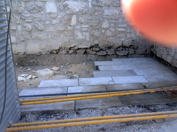
Zachi sent me a photograph showing a line of large stones below the northern wall of the raised platform.
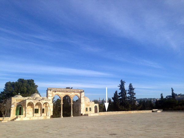
Needing more information, I asked a friend of Nathaniel, one of my sons, to send me additional photographs showing what is happening on the Temple Mount at present. The location in question is to the east of the eastern stairway that leads up to the raised platform from the north:
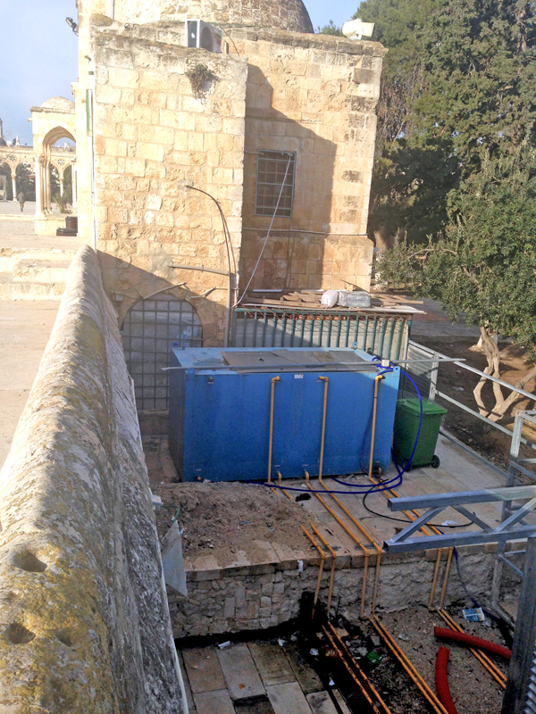
In the following picture, we see the area below the blue container that was lowered by about 1m. (3 feet):
The following photograph shows the single course of beautifully carved ashlars (large stones):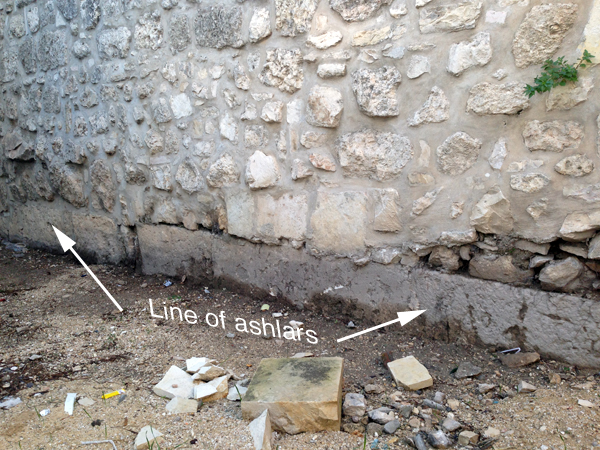
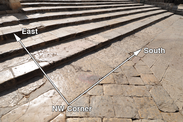
It is difficult to say when this monumental masonry was built, but it is located along the line of the northern wall of the raised platform, which we had previously (The Quest, pp. 165-186) identified as the northern boundary of the pre-Herodian Temple Mount. To the west of this same line is the northwest corner of the 500-cubit square Temple Mount of the First Temple period and we had suggested that this was built by King Hezekiah:
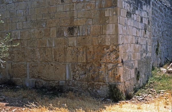
To the east of the newly discovered masonry there are equally large stones to be seen at the northeast corner of the raised platform.
Putting these three points together, we see that all three masonry remains lie on the northern boundary of the ancient square Temple Mount:
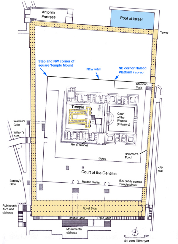
The masonry at the northwest corner of the square Temple Mount is characterised by rough bosses, while the other two sections have smooth masonry. It is possible that these two sections were built at a later time, above earlier masonry.
Reviewing the discovery of this new wall, we can see that it lies on the northern boundary of the ancient Temple Mount. It is unlikely that this wall was built in the Umayyad period as no other masonry of this calibre can be seen anywhere in the outer walls of the raised platform. No major building projects were carried out on the Temple Mount in the Byzantine period. That leaves us with either the Roman (Aelia Capitolina) or the Herodian period. Although we cannot prove it, the latter would be an exciting possibility! In any case, the fact that monumental masonry is built on the northern boundary of the ancient Temple Mount appears to confirm the location of the square Temple Mount of the First Temple period.
All this goes to show that many more archaeological remains may still be hidden below the surface of the Temple platform and how much more we could learn if excavations were made possible! This would be extremely valuable, as only excavation would make it possible to identify the period of these wall remains.

Dov,
The so-called “Extra Tower” that was discovered by Charles Warren in the 1860’s and is now visible in the Ophel Excavations, has been dated by Kathleen Kenyon and recently by Eilat Mazar to the 8th Century BCE. Its bossed masonry is virtually identical to that near the Golden Gate and the “Step”. Similar bossed masonry dating to the First Temple period has been found in Samaria. The masonry of Jeroboam’s temple platform in Tel Dan also has bossed masonry. The walls here enclose an artificial platform just as in Jerusalem, although on a smaller scale.
Why would they have built there mosque on this land? It is known they built on top of other holy sites when taking over, but what could they have found and have in their possession? If true, where did King David take the remains of the last temple when he moved to the city and supposedly took the ark?
There are far more important questions here to learned than carbon dating.
send the dome and its people back to mecca,rebuild the temple do the excavations …. when the temple is done all will be right in the world
I am truly grateful and equally fascinated by work to uncover the temple remains. It is necessary and productive work to enable us as human beings to understand our past as a means to understand our future. May the work continue, the politics be damned and perhaps someday we may see the temple in its’ true glory.
Mr. Ritmeyer,
I am so completely intrigued by this subject! Thank you for taking the time to answer questions about the Temple Mount area.
Is it possible that Solomon’s/Herod’s temple was actually located above the Gihon Spring on the Ophel mound in the City of David? If so, when do you think information and details could be made public.
Again thank you for taking to time to answer questions about this subject.
Dan,
It is utterly impossible that the Temple once stood in the City of David. See the correspondence at: https://www.ritmeyer.com/2015/02/20/new-archaeological-discoveries-on-the-temple-mount-in-jerusalem/
Is it possible that this masonry was part of the foundation of the Baris, or even of Fortress Antonia? What is its relationship to the “trench” identified by Wilson/Warren? That it belongs to a particular building style is not in itself an indication that it MUST be part of the Temple platform/enclosure; both the Temple and the Baris might have shared building techniques, and been built at the same time. And it seems to be close to the “trench” referenced above. The literature indicates that Antonia had a “moat” to its north.
Dennis, The “moat” was located to the north of the pre-Herodian Square Temple Mount, but south of the Antonia.It was filled in by Pompey in 63 BC.
Dr. Ritmeyer, I thoroughly enjoyed your work, “The Quest”, and I greatly appreciate the detail and exhaustive work you have produced from your time spent at the site. Being a Professional Land Surveyor, I can truly appreciate all of the details, measurements, and research required to provide all of the information gathered into your incredible work. It is also impressive to see everything that Warren and Wilson achieved with the resources they had at the time, with less technology, but true attention to detail regardless. I also would love to see the day that true archaeological work could progress at the Temple Mount, and if it is to happen with a future generation, may they perform their work as diligently and respectfully as yourself, Warren, and Wilson, “following in the footsteps” as we have been taught. In my experience as a Surveyor, there is no greater reward than finding an old buried property corner, all because of practicing “following in the footsteps.” I hope that you will be able to continue your work at the Temple Mount one day. – Sincerely, Jeff Elkins, Professional Land Surveyor; Professor of Survey Law
Jeff, good that you can appreciate that surveying is the groundwork that needs to be done before any conclusions can be drawn. The work that Wilson, Warren and myself have been able to do would be impossible under the present political situation.