Jerusalem Biblical Archaeology Map by Carta

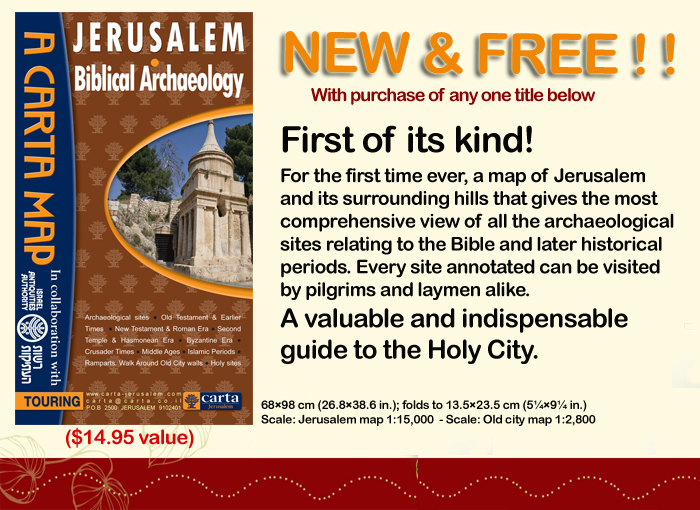
There was much excitement in our house last week when the Biblical Archaeology Jerusalem Map by Carta (see previous post) arrived.

Spreading the chart out on the table, we were able to retrace many of the trips and explorations we made when living in Jerusalem. At the time, some of these had required poring over Ordnance Survey maps and reading archaeological reports before we could identify the sites involved. Now, with the acquisition of this map, we can easily find the location of these sites, as well as, and most importantly, the latest sites to have been discovered.

Twenty-three years ago, the publication of the New Encyclopedia of Archaeological Excavations in the Holy Land, a a joint venture by the Israel Exploration Society, Carta, and Simon and Schuster’s Academic Reference Division, was a landmark in the quest to provide a comprehensive work that would summarize the results of archaeological work in the Land of Israel for the English reader. It had a 102-page long section on Jerusalem. Ephraim Stern wrote in the Editor’s Foreword to the Supplementary Volume, published in 2008:

“Since the publication in 1993 of the four volumes of the New Encyclopedia of Archaeological Excavations in the Holy Land (NEAEH) archaeological excavations have continued at a staggering pace. Many of the entries of those four volumes quickly became outdated and the need arose for this volume, which updates the NEAEH to the year 2005. It is a joint venture of the Israel Exploration Society and the Biblical Archaeology Society.”

So, while we await the next update, a mammoth undertaking, this handily portable map will play a vital role in guiding the visitor around the archaeological sites of Jerusalem,

The front part of this large map (63×94 cm, or 25×37 inches) shows the Old City and its surroundings, while the reverse side is dedicated to the Old City in much greater detail. The map was made in collaboration with the IAA (Israel Antiquities Authority, or Reshut Atiqot in Hebrew), with the text and scientific advice provided by Dr. Yuval Baruch. The archaeological sites are described in small text boxes with an arrow pointing to the exact location of each.

Most of the sites on the front part are familiar to us, but by no means all of them are. It is good to see the site of Lifta on the northwest of the city included. This has been identified as the site of the Waters of Nephtoah of Joshua 15.9 and 18.15, defining here the border between Benjamin and Judah. We remember exploring the village and its spring in the 1970’s, but then it seemed very much off the beaten track, being hidden away on two steep slopes in the last valley of the ascent into Jerusalem.

There are other sites we are not so familiar with such as Khirbet Adaseh North and Khirbet Adaseh, 2 miles to the southeast. Adasa, was, of course, the place where the Maccabees were victorious in their battle against the Seleucid general Nicanor, who lost his life there.

The Old City map is also informative with sections dedicated to the Kidron and Hinnom Valleys, Mount Zion, the City of David and the Aqueducts of Jerusalem. We are pleased that the Tomb of Annas the High Priest, a site we were able to identify in the early 1990’s, is included among the sites in the Hinnom Valley.

This drawing shows the Tomb of Annas as reconstructed according to the archaeological remains. The reconstruction drawing shows the triple-gated entrance to the tomb’s anteroom. This is based on the remains of the partly preserved semi-hemispherical conch above the central doorway and those of four pilasters, the outer ones showing an additional rounded moulding which was part of a frame. There are indications that the tomb once carried a superstructure and so could be identified as a monument.

A glaring omission on this side of the map is any detail on the vast platform of the Temple Mount. However, giving the impression that the site is a terra incognita is part of the political reality in this area. Only some of the gates are mentioned, with the Double and Triple Gates unfortunately still called the Huldah Gates. The original Huldah Gates were in fact located in the southern wall of the pre-Herodian Temple Mount some 72 m (240 ft) north of the present Southern Wall.

No reference is made to the Step, which is the remains of the Western Wall of King Hezekiah’s Square Temple Mount or of The Rock, identified by many as the site of the Holy of Holies of Solomon’s Temple. The many well-heads visible on the platform indicate the location of the many underground cisterns, of which two, Cisterns 6 and 36, may have been mikva’ot. These would also have added interest to this part of the map.

Information on the Temple Mount platform is, however, available in our guide book Jerusalem, the Temple Mount in which we have produced a map showing 19 points of archaeological and historical interest:

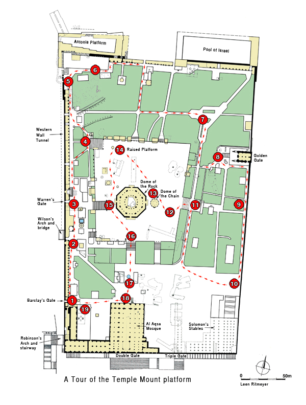
Despite these shortcomings, however, we foresee copies of this map being given as presents for those who love exploring the Old City of Jerusalem and its environs. And if you have friends visiting who have been to Jerusalem, framed reproductions are bound to stimulate some lively conversation.

Special Offer from Carta

Carta Jerusalem offers the new Jerusalem – Biblical Archaeology map for free with the purchase of one of three books mentioned below, including The Quest. In addition, each of the three titles can be purchased for 20% off the list price, i.e. $48.00 instead of $60.00. This excellent offer, which saves you almost $27.00 is valid until the 31st of January, 2017. When ordering, all you need to do is click on the Voucher code: 20-OFF, and the map will be added for free.

The three titles are:

Flooring from the Temple Mount in Jerusalem

The discovery of colored floor tiles found in the Temple Mount Sifting Project, that apparently came from the Herodian Temple Mount was announced during the 17th Annual Archaeological Conference in the City of David National Park held on the 8th of September 2016. This new find received plenty of media coverage, see for example this Jerusalem Post report. As usual the reporting took the form of copying and pasting the original report.

First of all, kudos to Frankie Snyder for having patiently fitted these many pieces together into meaningful designs. The stones have different geometrical shapes, were finely cut and polished and fitted tightly together to create beautiful designs. Such floor designs are called opus sectile, which is Latin for “cut stone”.

Frankie Snyder holds restored marble floor tiles based on fragments found in fill from the Temple Mount. Archaeologists from the Temple Mount Sifting Project say that these come from the Herodian Temple in Jerusalem. (Temple Mount Sifting Project)

I wanted to be sure, however, that what was presented could indeed have belonged to floors or pavements on the Temple Mount. When I first saw the pictures of Frankie’s floor designs, they reminded me of the beautifully designed tiled floors of the late nineteenth century house in Ethiopia Street in Jerusalem where we used to live. These floor designs have been used for a very long time. For example, many pieces of Crusader and earlier stone floor designs were found during the sifting, see here.

Looking at the photographs presented by the TMSP, however, I wondered why some tiles looked like marble:

A reconstructed tile from the Second Temple. (photo credit: Zachi Dvira/Temple Mount Sifting Project)
© Zachi Dvira/Temple Mount Sifting Project

Hardly any marble was imported into Israel until the time of Hadrian. In 135 AD, he established a Roman colony called Aelia Capitolina, on the ruins of Jerusalem, which had been destroyed in 70 AD. Evidence of the use of marble has been found from this period. For example, in the Temple Mount Excavations a Roman bath house with a marble-lined pool was uncovered, together with a marble statue.

So, I asked Frankie what materials these reconstructed tiles were made of, she replied that, apart from locally sourced stone, different types of imported marble were also used, such as giallo antico from Tunisia,  breccia corallina from Turkey, breccia di Settebasi from Greece and also alabaster from Egypt.

It was interesting to find out that the opus sectile pavement found in Herod’s Third Palace in Jericho also had pieces of marble worked into its design. Herod was a great lover of Roman art and architecture and apparently imported these tiles from around the Mediterranean.

Imprints of the opus sectile floor in Herod’s Palace at Jericho. Photo: Zev Radovan

Gabriel Barkay, one of the directors and co-founders of TMSP is sure of the Herodian date of the tiles they found:

“The materials of which they are made, colorful marble-like stones which originate from different locations and places around the basin of the Mediterranean. They were neither imported before the time of Herod the Great nor later, so we are sure of the date … Opus Sectile flooring is consistent with the style of flooring found in Herod’s palaces at Masada, Herodium, and Jericho, among others, as well as in majestic palaces and villas in Italy during the time of Herod. The tile segments, mostly imported from Rome, Asia Minor, Tunisia and Egypt, were created from polished multicolored stones cut in a variety of geometric shapes.”

Indeed, an opus sectile floor was found in the Peristyle Building in the Jewish Quarter Excavations. This was made of black bitumen and cream and red colored limestone.

Reconstruction of opus sectile floor found in the Jewish Quarter Excavations. Design: L. Ritmeyer

The question that remains unanswered is, where on the Temple Mount were such floors laid? The description of Josephus in War 5.193 was quoted: “The open court was from end to end variegated with paving of all manner of stones.” Does this refer to these opus sectile floors?

Herodian paving on the Temple Mount has been identified by us and reported on previously. These in situ remains show that the open courts of the Herodian Temple Mount were paved with very large and thick paving slabs made of local limestone, very similar to those laid in the streets that surround the Temple Mount.

All the known opus sectile floors were laid indoors and not outdoors. These delicately constructed floors would not have survived long outside in the sometimes harsh Mediterranean climate. We suggest therefore that they came from the interior of some of the many buildings that surrounded the Temple and/or from under the colonnades around the smaller courts.

The Temple, viewed from the east in this image, was surrounded by the Temple Court. Several gates and other buildings stood to the north and south of the Temple. On the east (centre front), was the large Court of the Women, also known in the Gospels as the Treasury, which had four smaller courts at its corners.


10th Anniversary of The Quest

In July 2006, my book The Quest: Revealing the Temple Mount in Jerusalem was published. The launch of The Quest took place at the  International Christian Retail Show in Denver, USA.

Holding the first copy of The Quest

I don’t know who was more excited to see this book in print, John E. Mancini of the Lamb Foundation who had sponsored me to write this book, Emanuel Hausman, Chairman of Carta Publishing in Jerusalem, or myself.

I dedicated the book to “John E. Mancini for sharing the vision to let the ancient stones tell their story and his unstinting support of The Quest.” We first met in Albuquerque, where Dr. Steven Collins, asked me to lecture on a regular basis as adjunct-professor at Trinity Southwest University in Albuquerque, NM, which he heads. I wrote this in the preface of The Quest:

For several years, Dr. Collins and I led tours to Israel. One participant, John E. Mancini, who with his wife Chris attended all our seminars and tours, expressed great interest in my research and was keen to make this material publicly available. John had already set up the Lamb Foundation to help Trinity and other projects, and during the fall of 1999 offered to help publish this book on the Temple Mount. I am delighted to thank him for the opportunity he gave me to devote myself to the presentation of my research carried out from the start of my archaeological career on the Temple Mount excavations in 1973. Thanks to John E. Mancini, to whom the book is dedicated, and all those who aided and accompanied me on this long and arduous journey, the public at large can now partake in the extensive documentation of Temple Mount history and archaeology provided by this volume and evaluate the proffered solutions to vexing questions.

Emanuel Hausman, Chairman of Carta Jerusalem (left), the author (centre) and John E. Mancini of the Lamb Foundation (right) in Denver, 2006.

Kathleen and I have experienced how pleasant it is to work with Carta, the Jerusalem publishers, on a number of publications. This book has, however, been a much more elaborate project. My thanks to all the people at Carta, their superb management and meticulous attention to the many details demanded by this title, especially to Barbara Laural Ball for her sensitive editing and general supervision of the project. Their proficiency can be seen on every page.

Ten years later, the book is still in demand and sells well and we have had many positive comments and favourable reviews. Yesterday, the 4th of July 2016, our book was chosen by the Temple Mount Sifting Project to top their list of the “10 Books To Read If You’re Into Archaeology and Israel” (even before the Hebrew Bible!).

This list was created by the staff of the Temple Mount Sifting Project in honor of their Book Week Campaign. It includes everything you need to know about Israel, Jerusalem, archaeology, and the Temple Mount.

1. The Quest: Revealing the Temple Mount in Jerusalem

The Quest: Revealing the Temple Mount in Jerusalem

This book is by Leen Ritmeyer. The recommendation was fought over by Gaby Barkay and Frankie Snyder. We will give them both credit.

“No book is better suited to the study, understanding and development of the manmade plateau that is the focus of the world s interest the Temple Mount in Jerusalem. Ritmeyer’s experience as architect of the Temple Mount Excavations following the Six-Day War, coupled with his exploration of parts of the mount now hardly accessible and his doctoral research into the problems of the Temple Mount make him singularly qualified for the task.”

The other books on the list look very interesting too!

Underground Jerusalem

Nir Sasson wrote a fascinating article in Haaretz on the underground excavations taking place in Jerusalem.

 Jerusalem has vastly expanded in the 7,000 years of its existence. Including, in the past two decades, downwards. Beneath the Old City, one can already walk hundreds of meters underground, pray in subterranean spaces of worship and see shows in subterranean caverns and halls. There are plans in place to dramatically increase this area – essentially, restoring the true ancient city beneath the visible one.

The article is accompanied by excellent plans, photographs and videos to bring you up to speed with what is happening underground. Despite protests from the Palestinians, who deny that the Jews have any historical connection with the Temple Mount, these digs do not penetrate below the Temple Mount.

Magnificent discoveries have been made in the City of David:

Near a 3,000-year-old fortification wall in the park’s center, or in the center of Silwan – depending on whom you ask, we descend underground through an iron door. It leads into a short tunnel that opens up into a series of rooms and halls. Here, in an area still closed to the public, fortification and water systems were discovered, mainly from the Canaanite period, or according to Jewish chronology – prior to the capture of the city by King David. Some have been known to science for over 100 years.

It is possible today to visit the underground remains in the City of David, see the Gihon Spring and walk through Hezekiah’s Tunnel that brings you to the Siloam Pool. From there one can walk underground through an ancient sewer below the Herodian street that leads up to just below Robinson’s Arch in the Temple Mount excavations, aka the Davidson Archeological Park. (see this video: 01_uknima)

A large stretch of the Herodian street had already been excavated above ground by the team of Prof. Benjamin Mazar in the 1970’s along the southern end of the Western Wall. The street that was found below Robinson’s Arch continues north to the Damascus Gate and south to the Siloam Pool in the City of David:

Before Mazar’s excavations, smaller parts of the same street  had been excavated lower down in the City of David by Bliss and Dickie in the 1890’s, in the 1930’s by Hamilton and in the 1960’s by Kathleen Kenyon.

In the last couple of years, underground excavations have apparently expanded and uncovered the full width of the Herodian street for a stretch of 120 meters. The original width was 7.50 meters. New tunnels are being dug to connect this street with the Givati parking lot excavations and the new visitor’s centre planned in this area just south of the Dung Gate.

To the north of the Western Wall Plaza one can walk through the Western Wall Tunnel and see the many new areas that have been excavated. The plan appears to be that in the future all these areas will be linked together, so that a “subterranean City of Jerusalem” can be visited.

Not everybody is happy about this development. One protester said:

“A huge excavation project is taking place here, hidden from the public eye, using outdated excavation methods. This is an excavation without boundaries and without any clear category, it’s not a research dig and not a rescue dig, it has no limit of time or place and no professional objectives.”

The excavation methods are not outdated, but these plans are very ambitious and politically controversial. However, once realised, a whole new experience is waiting for tourists to explore this “parallel universe” and enjoy a journey through “Underground Jerusalem”.


Two First Temple period seals found in Jerusalem

It has been reported that two seals have been found in the Givati Parking Lot excavations, bearing the names of a man and a woman, respectively “Sa‘aryahu ben Shabenyahu” and “Elihana bat Gael”. Their names are not mentioned in the Bible.

Seal of Sa‘aryahu ben Shabenyahu
Seal of Elihana bat Gael

Seals with names of women are pretty rare, so she must have been an influential person.  The excavators date the finds to about 2,600 years ago, but, we would agree with Todd Bolen, who suspects that the date is closer to 700-600 BC, i.e. the end of the First Temple period.

According to archaeologists, Dr. Doron Ben-Ami, Yana Tchekhanovets and Salome Cohen, excavation directors on behalf of the Israel Antiquities Authority, explain, “Personal seals, such as those of Elihana and Sa‘aryahu, were used for signing documents, and were frequently inlaid as part of a ring that was worn by the owner. In antiquity they designated the identity, genealogy and status of the owner of the seal”.

On the rare woman’s seal, which is made of semi-precious stone, appears the mirror-writing of “to Elihana bat Gael”, inscribed in ancient Hebrew letters. The female owner of the ring is mentioned here together with the name of her father.

According to Dr. Hagai Misgav of Hebrew University in Jerusalem, “Seals that belonged to women represent just a very small proportion of all the seals that have been discovered to date. This is because of the generally inferior economic status of women, apart from extraordinary instances such as this. Indeed, the name Elihana does not appear in the Bible, and there is no other information regarding the identity of the woman, but the fact that she possessed a seal demonstrates her high social status”. Dr. Misgav adds, “Most of the women’s seal that are known to us bear the name of the father rather than that of the husband.

These excavations claimed earlier to have found the remains of the Akra Fortress, which, however, may have belonged to the city’s fortification walls and not to the Fortress by the same name.

HT: Joe Lauer

The Mountain of the Lord

Joel Kramer of Sourceflix has posted a 6-minute long video called “The Mountain of the Lord” which has spectacular aerial footage.

Mount Moriah — the Mountain of the LORD. More than 4,000 years of recorded history have been played out on that particular spot, a location specifically chosen by God to accomplish His sovereign purposes. I have often tried to contemplate all that has happened there. The works of God are so overwhelmingly incomprehensible!

This video short will help you to ponder how the God of the Bible, through an amazing chain of historical events, transformed a lowly hill into what is today one of the most revered places on earth!

Another video explains the Topography of Jerusalem in a simple but effective way:

As a visual aid, we’ve developed a simple 3D model to help you picture the ridges, valleys and hills which have changed very little over several thousand years and which are the landscapes for the stories of Abraham and Isaac, King David and Christ.

Enjoy watching these videos which you can also download for a few dollars.

HT: Facebook page of Associates for Biblical Research.

3D model of Solomon’s Temple

Daniel Smith creates religious themed videos with the purpose of helping people better understand the history and culture of the Bible. You can see several of his videos on his website called Messages of Christ.

He contacted me saying that he read  of Solomon’s Temple in my book The Quest. He has now completed a 3D reconstruction of Solomon’s Temple in which he used my design of the interior walls.

Portions of 1 Kings 6 and 7 are read as you look around the video. Although I don’t agree with some of the details, the video is well worth watching.

Solomon’s Temple in Brazil

Last year, a new church building was constructed in São Paulo, Brazil, by the Universal Church of the Kingdom of God.

It is claimed that the design is based on Solomon’s Temple in Jerusalem, “but with increased dimensions”. It certainly is an impressive building, but it is hard to see a real comparison with Solomon’s Temple, which was much smaller and relatively tall. This new building serves as a church and has many rooms and even apartments, while Solomon’s Temple only had two rooms:

A reconstruction drawing of Solomon’s Temple, based on archaeological evidence and the description in 1 Kings 6. The Holy of Holies is placed on the Rock, which is actually the top of Mount Moriah and visible inside the Islamic Dome of the Rock. A special emplacement was cut in the rock for the Ark of the Covenant (1 Kings 8.6,21). The Altar stands in the threshing floor of Araunah, where David had previously built an altar (2 Sam. 24:18; 1Chr. 21:18).

The exterior of this new building looks squat and hasn’t got the elegance of Solomon’s Temple in Jerusalem. Nevertheless, it is interesting to see how the Ark of the Covenant is brought in, properly covered with a blue cloth, and all the other instruments. There also is a model of the Tabernacle. Here is a video:

Wikipedia has the following page:

The Temple serves as both a house of worship and as world headquarters for the Church. The mega-church seats 10,000 worshipers and stands 55 meters (180′) tall, the height of an 18-story building. Its dimensions therefore far exceed the temple it replicates, described in the Bible as having the relatively modest height of some thirteen meters (“thirty cubits”, 1 Kings 6:2).

The majority of the temple space is devoted to the main sanctuary. The sanctuary is lined with pews imported from Spain, which face the main altar. The sanctuary has a conveyor belt system designed to carry tithes and offerings from the altar directly into a safe room. The main ceiling is adorned with 10,000 LED light bulbs which will form different patterns designed to look like stars. Keeping with the Jewish theme of the temple, the walls are adorned with menorahs, and the entrance features a large central menorah.

The church spared no expense in designing the many other features of the temple. Aside from the main sanctuary, the temple also has 36 rooms for children’s Bible school, with a capacity of about 1,300 children, radio and television studios, a museum about the original temple, and 84 apartments of differing sizes for bishops and pastors of the church. The 11-story complex includes outdoor features such as a helicopter landing pad, a garden of olive trees based on the Garden of Gethsemane near Jerusalem, and flags of several countries. There is a parking lot able to accommodate 1,000 vehicles and 50 buses, classrooms for 1,300 children, and radio and television studios inside the building.

One of the most prominent features of the temple is its large central altar. It features an exact replica of the Ark of the Covenant, built to the specifications described in the Book of Exodus. The structure is entirely covered in gold leaf. Behind the ark is the temple’s baptistry, above the altar is 100 square meters of gold stained glass windows, and an inscription “Holiness to the Lord”.

The temple construction cost $300m and took four years to build.

HT: Alexander Schick