It has been reported, eg. here (Hebrew with pictures) and here, that remains of Jews who perished in the Great Revolt against the Romans and were discovered in Binyamin were secretly buried in Ofra.
The bones of Jews who perished in the Great Revolt by Jews against the Roman Empire, and which were discovered at an archaeological site near the community of Givat Assaf in the Binyamin region, were recently brought to burial secretly in Ofra.
The remains were discovered in 2013 at the archaeological site, which is a Jewish village from the time of the Second Temple. Mikvahs, coins from the time of the Great Revolt and vessels made out of stone were discovered at the site.
The bones belonged to seven women and a boy who hid in a cave, and were killed by the Romans in 69 CE, one year before the destruction of the Second Temple.
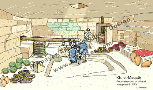
The archaeological excavation in question is Kh. el-Maqatir and was carried out by the Associates for Biblical Research, headed by Dr. Scott Stripling and Dr. Bryant Wood. I served as architect of the Maqatir excavation.
Five skeletons were found in a large cave that housed an oilpress and possibly also a winepress and three in a secret cave that led off from it.
An oilpress was discovered inside a cave at Kh. el-Maqatir. The olives were deposited through the hole in the ceiling and put in circular baskets. These were stacked and placed under a beam that was weighed down with stone weights. Nearby stood two upright stones that supported a screw press that may have been used for pressing grapes. The liquids were stored in the large vat at the right of the reconstruction drawing. Five skeletons were found here.
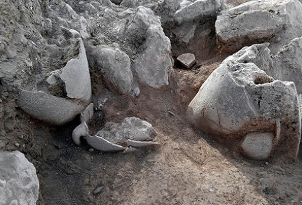
The Israel HaYom Newsletter announced today that new 10 ancient storage jars have been found in a new excavation in Shiloh:
Excavation at ancient Shiloh seeks to locate site of Jewish tabernacle that dates to the time the Jewish people first arrived in the land of Israel • “This is a very exciting find,” says Archaeology Coordinator in the Civil Administration Hanania Hizmi.
Storage vessels unearthed in Shiloh. Photo credit: Shiloh Association
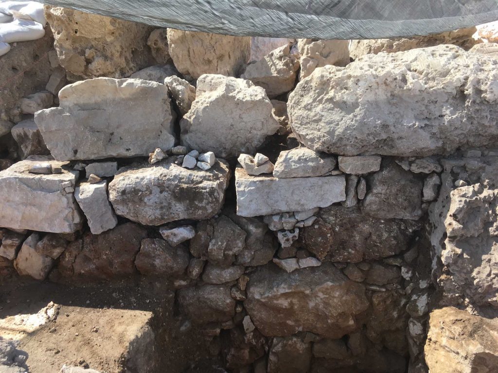
During the months of May/June 2017, excavations were carried out at Tel Shiloh[1]. At the conclusion of the dig, conservation work[2] needed to be carried out on some walls that were in danger of deterioration or collapse.
One section of the Middle Bronze Age city wall, W17 in Square AC-30, was selected for conservation. This wall was built of large ashlars, but in between these large stones were patches of small stones that needed to be consolidated (Fig. 1).
Fig. 1. The MBA city wall, W 17, before conservation. Note the many smaller stones that were placed in between the large ashlars.
Spreading the chart out on the table, we were able to retrace many of the trips and explorations we made when living in Jerusalem. At the time, some of these had required poring over Ordnance Survey maps and reading archaeological reports before we could identify the sites involved. Now, with the acquisition of this map, we can easily find the location of these sites, as well as, and most importantly, the latest sites to have been discovered.
Twenty-three years ago, the publication of the New Encyclopedia of Archaeological Excavations in the Holy Land, a a joint venture by the Israel Exploration Society, Carta, and Simon and Schuster’s Academic Reference Division, was a landmark in the quest to provide a comprehensive work that would summarize the results of archaeological work in the Land of Israel for the English reader. It had a 102-page long section on Jerusalem. Ephraim Stern wrote in the Editor’s Foreword to the Supplementary Volume, published in 2008:
“Since the publication in 1993 of the four volumes of the New Encyclopedia of Archaeological Excavations in the Holy Land (NEAEH) archaeological excavations have continued at a staggering pace. Many of the entries of those four volumes quickly became outdated and the need arose for this volume, which updates the NEAEH to the year 2005. It is a joint venture of the Israel Exploration Society and the Biblical Archaeology Society.”
So, while we await the next update, a mammoth undertaking, this handily portable map will play a vital role in guiding the visitor around the archaeological sites of Jerusalem,
The front part of this large map (63×94 cm, or 25×37 inches) shows the Old City and its surroundings, while the reverse side is dedicated to the Old City in much greater detail. The map was made in collaboration with the IAA (Israel Antiquities Authority, or Reshut Atiqot in Hebrew), with the text and scientific advice provided by Dr. Yuval Baruch. The archaeological sites are described in small text boxes with an arrow pointing to the exact location of each.
Most of the sites on the front part are familiar to us, but by no means all of them are. It is good to see the site of Lifta on the northwest of the city included. This has been identified as the site of the Waters of Nephtoah of Joshua 15.9 and 18.15, defining here the border between Benjamin and Judah. We remember exploring the village and its spring in the 1970’s, but then it seemed very much off the beaten track, being hidden away on two steep slopes in the last valley of the ascent into Jerusalem.
There are other sites we are not so familiar with such as Khirbet Adaseh North and Khirbet Adaseh, 2 miles to the southeast. Adasa, was, of course, the place where the Maccabees were victorious in their battle against the Seleucid general Nicanor, who lost his life there.
The Old City map is also informative with sections dedicated to the Kidron and Hinnom Valleys, Mount Zion, the City of David and the Aqueducts of Jerusalem. We are pleased that the Tomb of Annas the High Priest, a site we were able to identify in the early 1990’s, is included among the sites in the Hinnom Valley.
This drawing shows the Tomb of Annas as reconstructed according to the archaeological remains. The reconstruction drawing shows the triple-gated entrance to the tomb’s anteroom. This is based on the remains of the partly preserved semi-hemispherical conch above the central doorway and those of four pilasters, the outer ones showing an additional rounded moulding which was part of a frame. There are indications that the tomb once carried a superstructure and so could be identified as a monument.
A glaring omission on this side of the map is any detail on the vast platform of the Temple Mount. However, giving the impression that the site is a terra incognita is part of the political reality in this area. Only some of the gates are mentioned, with the Double and Triple Gates unfortunately still called the Huldah Gates. The original Huldah Gates were in fact located in the southern wall of the pre-Herodian Temple Mount some 72 m (240 ft) north of the present Southern Wall.
No reference is made to the Step, which is the remains of the Western Wall of King Hezekiah’s Square Temple Mount or of The Rock, identified by many as the site of the Holy of Holies of Solomon’s Temple. The many well-heads visible on the platform indicate the location of the many underground cisterns, of which two, Cisterns 6 and 36, may have been mikva’ot. These would also have added interest to this part of the map.
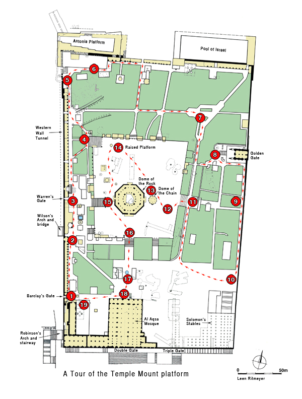
Information on the Temple Mount platform is, however, available in our guide bookJerusalem, the Temple Mount in which we have produced a map showing 19 points of archaeological and historical interest:
Despite these shortcomings, however, we foresee copies of this map being given as presents for those who love exploring the Old City of Jerusalem and its environs. And if you have friends visiting who have been to Jerusalem, framed reproductions are bound to stimulate some lively conversation.
It has been reported that two seals have been found in the Givati Parking Lot excavations, bearing the names of a man and a woman, respectively “Sa‘aryahu ben Shabenyahu” and “Elihana bat Gael”. Their names are not mentioned in the Bible.
Seal of Sa‘aryahu ben ShabenyahuSeal of Elihana bat Gael
Seals with names of women are pretty rare, so she must have been an influential person. The excavators date the finds to about 2,600 years ago, but, we would agree with Todd Bolen, who suspects that the date is closer to 700-600 BC, i.e. the end of the First Temple period.
According to archaeologists, Dr. Doron Ben-Ami, Yana Tchekhanovets and Salome Cohen, excavation directors on behalf of the Israel Antiquities Authority, explain, “Personal seals, such as those of Elihana and Sa‘aryahu, were used for signing documents, and were frequently inlaid as part of a ring that was worn by the owner. In antiquity they designated the identity, genealogy and status of the owner of the seal”.
On the rare woman’s seal, which is made of semi-precious stone, appears the mirror-writing of “to Elihana bat Gael”, inscribed in ancient Hebrew letters. The female owner of the ring is mentioned here together with the name of her father.
According to Dr. Hagai Misgav of Hebrew University in Jerusalem, “Seals that belonged to women represent just a very small proportion of all the seals that have been discovered to date. This is because of the generally inferior economic status of women, apart from extraordinary instances such as this. Indeed, the name Elihana does not appear in the Bible, and there is no other information regarding the identity of the woman, but the fact that she possessed a seal demonstrates her high social status”. Dr. Misgav adds, “Most of the women’s seal that are known to us bear the name of the father rather than that of the husband.
These excavations claimed earlier to have found the remains of the Akra Fortress, which, however, may have belonged to the city’s fortification walls and not to the Fortress by the same name.
The Hebrew University in Jerusalem announced today that in 2009, a bulla (clay impression of a seal) was found in the Ophel excavations bearing the name of King Hezekiah. The seal impression was found during the wet-sifting of earth layers from the Ophel excavation at the Temple Mount Sifting Project.
A seal impression of King Hezekiah unearthed in the Ophel excavations at the foot of the southern wall of the Temple Mount, conducted by the Hebrew University of Jerusalem’s Institute of Archaeology under the direction of Dr. Eilat Mazar. (Courtesy of Dr. Eilat Mazar; Photo by Ouria Tadmor)
The Ophel excavations at the foot of the southern wall of the Temple Mount, conducted by the Hebrew University of Jerusalem’s Institute of Archaeologyunder the direction of Dr. Eilat Mazar, have unearthed an impression of the royal seal of King Hezekiah (727–698 BCE).
Measuring 9.7 X 8.6 mm, the oval impression was imprinted on a 3 mm thick soft bulla (piece of inscribed clay) measuring 13 X 12 mm. Around the impression is the depression left by the frame of the ring in which the seal was set.
The impression bears an inscription in ancient Hebrew script:
“לחזקיהו [בן] אחז מלך יהדה”
“Belonging to Hezekiah [son of] Ahaz king of Judah”
and a two-winged sun, with wings turned downward, flanked by two ankh symbols symbolizing life.
Eilat Mazar eplains the significance of this find in this video. Seal impressions of this famous king who is described in the Bible as “”there was none like him among all the kings of Judah” (2 Kings 18:5)”, have been found earlier, but not in the context of a scientifically run excavation.
The seal was found in debris outside the eastern part of the so-called Royal Structure and was discarded probably through one of the windows of the building. This area is familiar to me as I was initially put in charge of its excavation by the late Prof. Benjamin Mazar and excavated remains of an Herodian building. The Iron Age remains were found below this level.
Prof. Benjamin Mazar (centre with red hat) and myself (left) discussing the excavations in the Opel area. Remains of the Herodian buildings can be seen on the left.
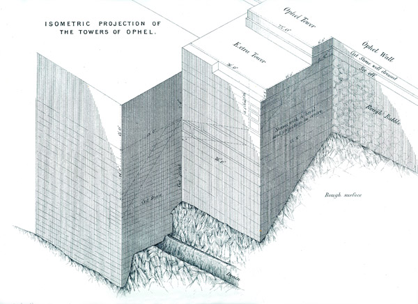
The place where the seal was found is close to a large tower that was apparently added to the existing fortifications by King Hezekiah. Warren dubbed this tower the Extra Tower.
Warrren’s drawing of the Extra Tower. The seal was found to the right of the image.
Kathleen Kenyon also excavated here in the 1960’s and uncovered the remains of this structure in her Area SII. This fortification of Jerusalem was part of Hezekiah’s expansion of the city.
Many other building works of Hezekiah have been uncovered in the Jerusalem excavations, such as the Broad Wall in the Jewish Quarter of the Old City of Jerusalem. This wall is referred to in Isa. 22.10 and was part of the new city walls that Hezekiah built around the previously unprotected Western Hill.
During the reign of King Hezekiah, many refugees from the Assyrian invasion of the northern tribes came to Jerusalem for protection. As the city on the Eastern Hill was too small to accommodate the new comers, they settled on the Western Hill. Eventually, King Hezekiah built a new city wall around this hill to protect it from invasion.
The article of the Hebrew University gives a fascinating insight into the significance of the change in King Hezekiah’s personal symbols:
The symbols on the seal impression from the Ophel suggest that they were made late in his life, when both the Royal administrative authority and the King’s personal symbols changed from the winged scarab (dung beetle)—the symbol of power and rule that had been familiar throughout the Ancient Near East, to that of the winged sun—a motif that proclaimed God’s protection, which gave the regime its legitimacy and power, also widespread throughout the Ancient Near East and used by the Assyrian Kings.
This change most likely reflected both the Assyrian influence and Hezekiah’s desire to emphasize his political sovereignty, and Hezekiah’s own profound awareness of the powerful patronage given his reign by the God of Israel. While the changed Royal administrative symbol imprinted on the King’s jars used the motif of a sun with wings extended to the sides, Hezekiah’s personal changed symbol had a sun with sheltering wings turned down and a life-symbol at the end of each wing. This special addition of the symbol of life may support the assumption that the change on the King’s personal seal was made after Hezekiah had recovered from the life-threatening illness of shehin (II Kings 20:1-8), when the life-symbol became especially significant for him (ca. 704 BCE).
I have been asked by a few readers to clarify my position on the location of the Akra, that hated symbol of alien Hellenistic rule whose occupiers became in the words of the writer of the First Book of Maccabees: “a great trouble … an ambush for the sanctuary, an evil adversary for Israel at all times” (1. 35 – 38). This was because they attacked the Jewish worshippers that went up from the city to the Temple.
Let me say, first of all, that the finds in the Givati Parking Lot (announced on November 3rd) and identified as part of the Akra, are very significant. According to the excavators, a 4m wide and 20m long defensive wall dating to the Hellenistic period was found with a glacis, made up of soft layers of rubble, descending to the bottom of the Tyropoeon Valley. This therefore indicates that this wall was part of the western fortifications of Hellenistic Jerusalem. The difficulty is to establish what part of the Hellenistic city this wall belongs to. Now that the media pundits have regurgitated the news announcement, it is time to reflect on this latest identification of the Seleucid Akra.
The most important information about the Akra comes from two historical sources, namely the works of Josephus and the above mentioned First Book of Maccabees. The problem with these sources is that they are not easy to harmonise. However, we must not shy away from them, but try to interpret them in the light of these and other archaeological findings. First to quote from the previous verse from the Book of Maccabees to the one above.
“And they built the city of David with a great and strong wall, and with strong towers, and made it a fortress [Greek: Acra] for them: And they placed there a sinful nation, wicked men, and they fortified themselves therein.”
This quote shows us that the City of David, which is the southern part of what Josephus calls the Lower City (see map), was fortified all around to turn it into a fortress.
This does not mean that the City of David was the Akra Fortress, but that it was as strongly fortified as a stronghold. The wall in the Givati Parking Lot belongs to the western fortifications. Interestingly, it is in direct line with the Valley Gate that was excavated a little further south by J.W. Crowfoot in 1927. This excavator was of the opinion that this wall section with its gate belonged to an early period and was restored probably during the time of Nehemiah and certainly in the Maccabean period*.
The Valley Gate that was excavated in 1927 by Crowfoot.
On the eastern side, a similarly strong wall with a glacis was excavated by Yigal Shiloh in the excavations he carried out in the City of David from 1978 – 82.
Area G, general view with glacis indicated. From:Yigal Shiloh, Excavations at the City of David, Qedem 19, Plate 36.Close-up view of the glacis in Area G.
These excavated wall sections, both in the west and in the east, were all part of the fortifications of the City of David in the Hellenistic period (c. 300 B.C. – 141 B.C.). These walls would have continued further north and were connected with the Temple Mount.
The Temple Mount at that time still had the 500 cubit square shape that was given it in the First Temple period, probably by King Hezekiah. The square mount was rebuilt by Nehemiah and continued to exist in this form until the Hasmonean period (141 B.C. – 37 B.C.).
After the Babylonian Exile, many Jews returned to Jerusalem. They came in relatively small numbers, not sufficient to occupy both the Eastern and Western Hills. In this annotated drawing we see the rebuilt city of Jerusalem on the Eastern Hill with a smaller Temple on Mount Moriah. The reconstructed Temple Mount had gates and towers and chambers along the inside of its boundaries. The Ophel was to the south of the Temple. The city walls have been reconstructed following archaeological remains that have been found, complemented by the description of the walls in Nehemiah Chapter 3.
The other main source on the Akra, Josephus, tells us that, apart from fortifying the City of David, a separate fortress or citadel was also built by the Seleucids next to the Temple Mount:
“…and when he had overthrown the city walls, he built a citadel [Greek: Acra] in the lower part of the city, for the place was high, and overlooked the temple; on which account he fortified it with high walls and towers, and put into it a garrison of Macedonians”, Antiquities of the Jews12:252–253
This quote from Josephus speaks of a citadel that was built in the highest place of the Lower City. What did the term “Lower City” mean in the time of Josephus? In describing the City of Jerusalem, Josephus (War 5.136-141) describes two hills, the upper city which had a straight ridge and was higher than the Lower City. The Upper City was located on the Western Hill of Jerusalem (where the Jewish and Armenian Quarters are today). The Lower City, which bore the name of Akra and was shaped like a hog’s back, was located on the Eastern Hill south of the Temple Mount. The valley in between the Western and Eastern Hills is called the Central or Tyropoeon Valley.
It is important to make a distinction between the Lower City that was built like a fortress (akra) and the separate citadel or fortress itself that was called the Akra. The two, the city and the citadel, are not the same in the historical sources. This is made abundantly clear in the Book of Maccabees, where it is recorded that Jonathan “decided … to erect a high barrier (wall) between the Akra and the city, to separate it from the city and isolate it” (1 Macc 12:36). The Akra citadel therefore clearly stood in between the city and the Temple.
Let us now concentrate on the citadel named the Akra. What do we know about it?
Antiochus IV Epiphanes built the Akra in 168 B.C., a fortress for his Macedonian garrison from which the Jewish population could be controlled. Josephus records that it “commanded or overlooked the Temple”. Josephus writes in Antiquities 12.252 that Antiochus:
“… built the Akra in the Lower City; for it was high enough to overlook the Temple, and it was for this reason that he fortified it with high walls and towers, and stationed a Macedonian garrison therein. Nonetheless there remained in the Akra those of the (Jewish) people who were impious and of bad character, and at their hands the citizens were destined to suffer many terrible things.”
This is later confirmed by Josephus (Ant.12.362):
At this time the garrison in the Akra of Jerusalem and the Jewish renegades did much harm to the Jews; for when they went up to the Temple with the intention of sacrificing, the garrison would sally out and kill them—for the Akra commanded the Temple.
The Akra fortress therefore must have stood close to the Temple and overlooked it. The Temple Mount of that time was smaller than the present-day Temple Mount. In the Hellenistic period the Temple Mount still had a square shape, as it had in the time of Nehemiah. The distance between the Givati excavations and the southern wall of the square Temple Mount is 720 feet (220m) and the excavations are lower by some 150 feet (50m). It is impossible for the Akra fortress to have been situated in that location as it is too far from the Temple Mount and too low. The Seleucids would have had to construct a skyscraper of more than 150 feet (50m) in height, the approximate height of an 18 storey high modern building or the Temple in the time of Herod the Great. In the quote above of War 5, Josephus continues to inform us that the Hasmoneans:
“filled up the valley, with the object of uniting the city to the Temple, and also reduced the elevation of Acra by leveling its summit, in order that it might not block the view of the temple.”
In our previous quote we mentioned that Josephus also wrote that after Simon the Maccabee had razed the Akra, he “thought it would be an excellent thing and to his advantage to level also the hill on which the Akra stood, in order that the Temple might be higher than this” (Ant. 13.215).
It reasons therefore that the Akra was totally destroyed and dismantled and the ground on which it stood was leveled. As Josephus records that it took three years to raze the Akra and the promontory of the Lower City on which it stood, I believe therefore that it would be impossible to ever find any remains of this fortress.
Josephus further confirms (Ant. 12.406) that the Akra was built adjacent to the Temple Mount as he states that “Nicanor was coming down from the Akra to the Temple.”This clearly shows that the Akra must have been built very close to the Temple Mount, if not right up against it, see drawing below reproduced from my previous post.
The Akra was a formidable fortress with a garrison permanently stationed in it. It was therefore necessary to have a good water supply. Adjacent to the projected southern wall of the square Temple Mount is a curiously shaped cistern. Its plan is in the form of the letter E, which is unlike all the other, mainly irregularly shaped, cisterns of the Temple Mount. This Cistern 11 was explored by Warren and described by Conder as follows,
It is 61 feet 6 inches (18.75 m) deep and consists of three tanks, each about 26 feet (7.9 m) by 40 feet (12.2 m) connected by a passage running north and south and 14 feet (4.30 m) wide. The total contents are about 700,000 gallons (3,200 m3). The roof is of rock cut out into arches. Steps on the west ascend to the mouth of the tank and west of these are foundations of a massive wall on the rock. The passage from the Triple Gate is continued, so as to run over this tank.
This tank is located just south of the square Temple Mount, in an area that is totally flat and its position suggests that it was specially cut to provide the Macedonian garrison stationed in the Akra with a water supply ample enough to withstand a long siege. Stones quarried from this cistern may initially have provided building material for the Akra.
Interestingly, the tractate Erubin of the Mishnah calls one of the cisterns of the Temple Mount be’er haqqer. This name, which means “The Cistern of the Akra,” suggests that one of the cisterns of the Temple Mount was named after the fortress that lay on top of it. In addition, the presence of the foundations of a massive wall in this cistern, described by Warren, together with the cistern’s peculiar E-shape, suggest a design that would support a large building.
The literary evidence, combined with the unusually shaped Cistern 11, provides the first tangible evidence for the location of the Akra in the northern part of the area between the Double and Triple Gate passageways.
The finding of the Hellenistic city wall with its glacis in the Givati Parking lot has contributed much to our understanding of Jerusalem in the pre-Hasmonean period. This wall, however, belongs to the city walls of that time and has nothing to do with the infamous citadel of the Akra.
* J. Simons, Jerusalem in the Old Testament (Brill, 1952), 90.
A fascinating discovery recently uncovered in archaeological excavations the Israel Antiquities Authority is conducting in the Givati parking lot at the City of David, in the Jerusalem Walls National Park, has apparently led to solving one of Jerusalem’s greatest archaeological mysteries: the question of the location of the Greek (Seleucid) Acra–the famous stronghold built by Antiochus IV in order to control Jerusalem and monitor activity in the Temple which was eventually liberated by the Hasmoneans from Greek rule.
Hellenistic walls found in the Givati excavations. Photo: Assaf Peretz, courtesy IAA
It is true that the location of the Seleucid Akra has baffled archaeologists for a long time. In 2006 I wrote:
Among scholars, there is less disagreement about the historical interpretation of the Books of Maccabees and Josephus than about the topographical problems connected with the location of the Seleucid Akra, which are styled the “most debated,” “most enigmatic and “thorniest” by Simons, Avigad and Wightman, respectively.
But could the Akra have been located so far away from the Temple Mount? Both the Book of Maccabees, as well as the historian Josephus Flavius, locate the Acra in the lower city of Jerusalem:
“And they built the city of David with a great and strong wall, and with strong towers, and made it a fortress [Greek: Acra] for them: And they placed there a sinful nation, wicked men, and they fortified themselves therein” — 1 Maccabees 1:35–38
“…and when he had overthrown the city walls, he built a citadel [Greek: Acra] in the lower part of the city, for the place was high, and overlooked the temple; on which account he fortified it with high walls and towers, and put into it a garrison of Macedonians.” — Flavius Josephus, Antiquities of the Jews 12:252–253
The quote from 1 Maccabees tells us that the whole of the City of David was fortified with a wall. The Hellenistic walls found here may indeed be part of these fortifications. Josephus, however, is speaking of a separate citadel – the Seleucid Akra. This fortress we are told “overlooked the temple”. In order for the Givati remains to belong to this citadel and also overlook the Temple, it must have been over 400 feet high at least.
Once the Akra was destroyed by the Maccabees, the whole area was leveled and added to the Temple Mount. Following that, 1 Maccabees 13.52 and 14.37 tell us that,
“He strengthened the fortifications of the Temple Mount by the side of the Akra, and took up residence there with his men.… He settled Jewish soldiers in it and fortified it as a protection for the country and city, and heightened the walls of Jerusalem.”
This appears to indicate that a large area, previously occupied by the Akra, was built adjacent to the Temple Mount. This extension can still be seen at the “seam” in the Eastern Wall of the Temple Mount.
The seam in the Eastern Wall of the Temple Mount is located 106 feet orn 32 m north of the southeast corner. It shows Herodian masonry to its left (south) and Hasmonean to its right (north). Photo: Leen Ritmeyer
The fact that the Akra previouslyoverlooked the Temple Mount means that the Temple Mount could be overlooked by someone standing on the highest parts of this fortress. The fact that the southeast hill slopes away rapidly in all directions to the south of the square Temple Mount excludes all but the highest rock levels near the southern wall of the square Temple Mount as the only possible location for the Akra.
One of the cisterns in the southern part of the Temple Mount – Cistern 11 – was known as the Cistern of the Akra (Mishnah Erubin 10.14). Josephus also writes that after Simon the Maccabee had razed the Akra, “thought it would be an excellent thing and to his advantage to level also the hill on which the Akra stood, in order that the Temple might be higher than this” (Ant. 13.215).
Plan of the Cisterns of the temple Mount, indicating the location of the Cistern of the Akra. Plan: Leen Ritmeyer
The Seleucid Akra therefore stood on a hill very close to the Temple Mount. What hill is there to be seen in the Givati parking lot? It appears therefore that the Israel Antiquities Authority once again tries to make sensational headlines with an unworkable theory in order to get some publicity.
Today, Monday, November 2, 2015, the IAA circulated English and Hebrew invitations to the media to attend a press conference tomorrow (Tuesday, November 3, 2015), in the Givati parking lot at the City of David, in the Jerusalem Walls National Park, where “A Solution to One of the Greatest Questions in the History of Jerusalem” will be presented.
The Hebrew invitation states that the presentation will be made at 10:00 AM.
The English invitation states that the conference will be held at 11:30 AM, and “Archaeologists of the Israel Antiquities Authority will present the finds (in English and Russian).”
The invitation was first issued on Tuesday, October 13, 2015, and withdrawn the same day with the note that “In light of the current security situation, it was decided to postpone the event….” It can only be hoped that the decision to hold the event tomorrow is a good sign.
Now we will just have to wait for “A Solution to One of the Greatest Questions in the History of Jerusalem”.
“I appreciate your fantastic research work very much!
I have a question about “the bend” in the eastern wall. The 500 cubit thesis is convincing.
But I wonder that during the so called “big dig” to create the new underground mosque entrance at the south-east corner there were no remains or traces of the south wall intersection at “the bend” or at “the seam” position running to the west. Wouldn’t you have expect even some evidence of walls coming out of the eastern wall?”
Plan of the Temple Mount showing the location of the stairway in red.
I promised to answer this question in a blog post, as it may also be of interest to other readers. On the above plan of the Temple Mount that shows various routes around the sacred complex and that appears in our newly published guide book, I have indicated the location of the area in question near the southeast corner. This site was illegally dug out in 1999 and a stairway was constructed in 2000 to create an access to the underground Solomon’s Stables, that have been converted into the al-Marwani mosque. During the digging, hundreds of tonnes of soil were dug out by bulldozer and dumped in the Kedron Valley. This soil is still being examined by the Temple Mount Sifting Project (TMSP).
Digging in front of Solomon’s Stables (nov. 1999). Picture: TMSP
Although some sizeable stones were removed, it appears that no Herodian or pre-Herodian walls were found in situ during those illegal diggings. The question of our reader is if that was to be expected? If one only looks at plans then such a question could indeed arise. The Bend represents the southeast corner of the square Temple Mount that was made by King Hezekiah in the 8th century BC, during what is known in archaeology as the Iron Age 2 period. The Eastern Wall of the Iron Age Temple Mount clearly still exists. Two long sections of this early wall can be seen on either side of the Golden Gate and a few other wall stones of the same period are visible near the Bend. It stands to reason therefore that remains of the Southern Wall of the Iron Age Temple Mount may also still exist.
King Hezekiah (725–697 BC) embarked on a major rebuilding program of the Temple, as reflected in the second and later accounts of the Temple construction in 2 Chronicles 3–4. Judging by the masonry style of the central part of the Eastern Wall and other archaeological remains on the Temple Mount, it appears that King Hezekiah surrounded this sacred complex with a massive 500-cubit-square artificial platform, called har habbayit in Mishnah Middot 2.1.
I have learned however, that looking at plans alone is not sufficient to obtain the complete picture. The secret to gaining a full understanding of buildings, modern or ancient, is to examine elevations and sections too. Let’s have a look at the elevation of the Eastern Wall of the Temple Mount:
In this drawing, the red lines indicate the interior level of the Temple Mount and the sloping area that was dug out by bulldozer. It shows that at no point did the diggings go deep enough to reach the preserved tops of ancient walls, although they came very close to reaching them. This does not mean to say that the excavations can be justified, but it is reassuring to know that it is unlikely that ancient walls might have been found and damaged.
Studying these levels, it appears that the southern walls of the Square Temple Mount and that of the Hasmonean period may still exist. Perhaps they may even be excavated under archaeological supervision at some time in the unforseeable future! At least, for now, they are well preserved.
Originally, these walls must have stood higher than the level of the Temple Mount in the relevant periods. The Royal Stoa that was built by King Herod the Great at the southern end of the Temple Mount stood partly over the Southern Wall of the Hasmonean Temple Mount which, in the east, began at the Seam. Any part of the Hasmonean extension that stood above the projected floor level of the Royal Stoa must have been dismantled at the time of building.
The drawing above is a detail of the Development of the Eastern Wall of the Temple Mount drawing:
The Eastern Wall of the Temple Mount is 1536 feet (468 m) long. The central part of this wall (shown in blue) dates from the time of King Hezekiah. The gate just below and to the right of the Temple is the Shushan Gate. To the south of the central section is a Hasmonean extension (red), while both ends of this wall were further extended by Herod the Great (yellow). The Herodian extension to the north of the central part of the Eastern Wall (Hezekiah’s expansion) required the filling in of a deep valley.
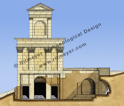
Many more images of the Temple Mount in the various periods and other archaeological sites are available from our Image Library. Below is is a reconstruction drawing of the Royal Stoa from our Image Library:
This is a section through the Royal Stoa that stood at the southern end of Herod’s Temple Mount. The Royal Stoa was the largest structure on the Temple Mount and was built in the style of a basilica. It had a central nave and two side aisles with four rows of 40 columns. Josephus calls this stoa more deserving of mention than any structure under the sun. The Royal Stoa was used as a sacred market place, where money could be changed and smaller animals for sacrifice purchased. It could have been the place, therefore, where Jesus overturned the tables of the money changers and those that sold doves (Matthew 21.1-16).