A smooth stone found in the Western Wall of the Temple Mount in Jerusalem

Nadav Shagrai wrote a lengthy article, called A Heart of Stone, in Israel Hayom about the amazing feat of tunneling deep underground along the foundations of the Western Wall by Eli Shukron and his team. This uncovering has undoubtedly increased our understanding of how this mighty wall, and indeed all other walls too, were constructed. It was reported earlier that some coins dating from about 17-18 CE had been found in the fill of a mikveh below the Western Wall. This find was used to suggest that not Herod the Great, but one or more of his sons completed the project.

This stretch of foundation stones of the Western Wall is located right next to the main drain that runs the full length of the Herodian street that began at the Damascus Gate and ended at the southern gate near the Siloam Pool. One doesn’t need much imagination to understand that maintenance work would have frequently been carried out in and near the drain during the long period that it was in use. The filling in of the above mentioned mikveh, that was located in between the drain and the foundation of the Western Wall, could have been carried out during such work.

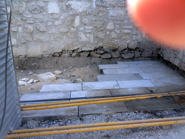
It is now also reported that one of the Herodian foundation stones had no margins, but a smooth finish. This what Eli has to say:
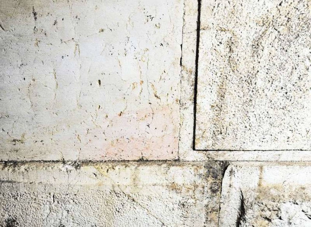
Photo of the smooth stone at upper left. Photo credit: Vladimir Neichin

“This stone came from the Temple Mount, from the surplus stones that were used in the construction of the Temple itself. Those stones were high-quality, chiseled and smooth, like this unusual one, which was discovered among the Western Wall’s foundations. This stone was intended for the Second Temple, and stones like it were used to build the Temple — but it was left unused. The builders of the Western Wall brought it down here because it was no longer needed up above — and this is how the other stones of the Temple looked,” he says, adding, “Anyone who passes a hand gently over this stone feels a slightly wavy texture, just like the Talmud describes.”

It is true that all the external faces of the Herodian stones have margins on all four sides, apart from this unique stone. The suggestion that this particular stone could have come from the Temple itself would have been a possibility if only the stones that were used to build the Temple had a smooth finish. That, however, is not the case. In studying Herodian architecture, one needs to differentiate between external and internal finishes of the stones. The internal parts of the stones that make up the retaining walls were never seen and therefore were roughly squared on the inside. The stones of the Western Wall above the level of the Temple Mount could be seen from inside the porticoes that were built all around. The interior finish of these stones was smooth. Several of these stones were found in the Temple Mount Excavations. One such stone was later reused in a Byzantine building. That stone was a pilaster stone, part of the outer wall of the porticoes that ran above the Temple Mount retaining walls. These stones had an external finish with margins, like the ones we see today, and a smooth internal finish. From the inside therefore, the portico wall looked smooth. It is quite possible, and indeed more likely,  that the newly discovered smooth stone came from the porticoes and not necessarily from the Temple itself.

It is necessary to exercise caution before suggesting that this smooth stone must have come from the Temple. Although it is exciting to find the first in situ stone without margins, one needs to be careful not to draw unwarranted conclusions.

HT: Joe Lauer

2,000-year old chisel found near the Temple Mount

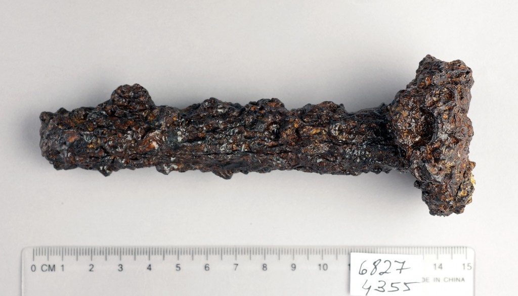
In today’s Ha’aretz newspaper, Nir Hasson reports on the finding of a chisel that dates back to the building of Herod’s Temple Mount. It was found at the base of the Western Wall, some 6 meters below the Herodian street. It certainly looks like a chisel that masons used to carve stones with. The flattened head was caused, not from “being repeatedly banged on rock”, but by the hammer that was used by the masons.

Photo by Clara Amit, Israel Antiquities Authority

Shukron who excavates the Herodian drain beneath Robinson’s Arch, said:

It is true that the rocks comprising the Western Wall had been transported there from far away. But the final work on the giant stones, and the job of fitting them with incredible precision, were done on site.

One wouldn’t use chisels, however, to fit the stones together. That was done by cranes and levers. The stones of the Temple Mount walls were completely finished in the quarry and then transported to the building site.

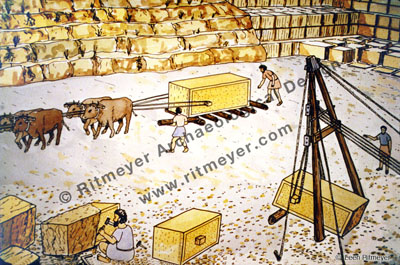
After quarrying, the rough stone blocks were dressed on site, taking care to leave small projections of two sides of the stone. Using a crane, ropes were looped around the projections and the stone lifted up on one side. Wooden rollers were placed below the stone, so that it could be transported. Teams of oxen were used to pull the stones. © Leen Ritmeyer

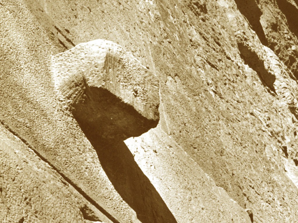
To lift the stones, the masons left small projections on the side of the stones, and those were cut off once the stones were in place. The short chisel that was found, would have been eminently suitable for that job.

A projection, used to lift the stones. They were chiselled off once the stone was in place. This knob on one of the stones of the Eastern Wall, however, survived. Perhaps it was forgotten or the scaffolding had been prematurely taken down.

Although coins from the beginning of the first century were found, that does not necessarily indicate that the Western Wall was finished after Herod’s death. If that would have been the case, then the Royal Stoa must have been built later too. None of Herod’s sons would have had the means or the vision to complete the building of the southern part of the Temple Mount. These coins were probably dropped  later by workmen doing maintenance or repair works to the Herodian drain.

HT: Joe Lauer
New City of David Centre approved

It was announced today that the new City of David Centre for visitors, called in Hebrew “Mercaz Kedem” has been approved. It is to be built over the archaeological remains found in the Givati Parking lot. Ari Yashar of Arutz Sheva writes:

“The plan to build the visitors’ center will aid in exposing the important archaeological finds to the broader public and serve as a focus for tourism that will help in developing the city of Jerusalem,” noted the Committee’s announcement of the project’s approval.

The new approval will advance construction on the center, containing a museum, visitors’ center and auditorium in City of David’s Givati parking lot excavation site, reports Haaretz. The center will also provide access to the City of David National Park, and display recent archaeological finds.

In approving the project, the Committee gave conditions that the height of the building must not exceed the street level above the area near the Old City wall, so as to maintain the general building height in the neighborhood. The center’s roof and passages to the lower level were ordered to be open to the public.”

The following illustration was published in Haaretz newspaper:

The building was designed by the architect Arie Rahamimov. According to the Ministry of Interior:

“The plan is an example of outstanding architecture that will contribute to the development of the national park and create public space that befits the location within the site and the city, as well as address the needs of the million and a half annual visitors to the national park.”

In order to facilitate the new building, a complex built by Silwan residents that included a playground, community center and cafe, was razed, drawing criticism from local residents and left-wing groups in Israel.

Conclusion of City of David Excavations

The Jerusalem Post carried an article yesterday on the conclusion of the excavations in the area of the Gihon Spring in the City of David. Ronny Reich of the University of Haifa and Eli Shukrun of the Antiquities Authority uncovered a huge Canaanite fortress built around this life-giving spring to protect it from invaders. This fortress was connected to the walled City of David by a strongly fortified passageway. Oriya Dasberg, the director of the development in the City of David, commented:

“The Spring Citadel was built in order to save and protect the water of the city from enemies coming to conquer it, as well as to protect the people going down to the spring to get water and bring it back up to the city.”

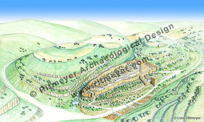
In a  video made by Eli Mandelbaum, Joe Uziel explains what was found. Initially, the excavators thought that these massive fortifications surrounded only the spring and the pool, as shown in a previous post. It is plausible that an area to the south was included in this fortified area, perhaps even larger than this reconstruction drawing suggests:

This drawing shows the City of David on the Eastern Hill of Jerusalem. The Kidron Valley is to the east (right in the drawing) and the Hinnom Valley to the west (left). The Central Valley (later called the Tyropoeon Valley) runs between the two. The Western Hill (left) remained unoccupied and unfortified till the time of Hezekiah. This drawing also shows a fortified area to the east of the City of David with a large tower.

Future excavations will hopefully cast further light on the eastern extent of the City of David.

HT: Bibleplaces.com

New Discoveries on the Temple Mount in Jerusalem

I was alerted by Zachi Dvira of  The Temple Mount Sifting Project to new excavation activities on the Temple Mount:

Recently, the ground level near the new generator room north of the raised platform was lowered by one foot. This work exposed an unknown course of stones from an earlier phase of this wall. This course could be dated to the Early Umayyad period or even the Herodian Period. L. Ritmeyer suggested that the foundation of this course was the original northern wall of the Temple Mount, and there is evidence for this thesis in various spots along this line.

Zachi sent me a photograph showing a line of large stones below the northern wall of the raised platform.

The newly discovered stones are below the platform wall at the back of the picture. New paving is being laid against it. Photo: Zachi Dvira

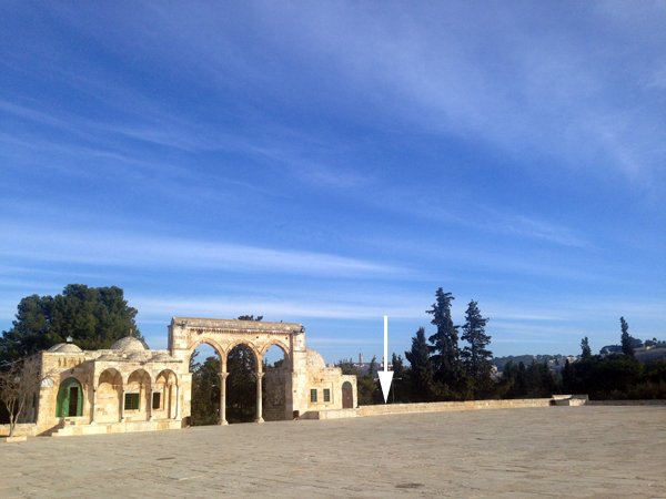
Needing more information, I asked a friend of Nathaniel, one of my sons, to send me additional photographs showing what is happening on the Temple Mount at present. The location in question is to the east of the eastern stairway that leads up to the raised platform from the north:

Looking northeast, the site in question is behind and below the wall where the arrow points

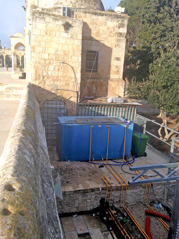
In the following picture, we see the area below the blue container that was lowered by about 1m. (3 feet):

The area in lower foreground has been lowered, exposing a line of ancient ashlars at the foot of the platform wall on the left.

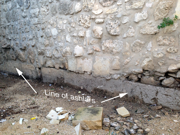
The following photograph shows the single course of beautifully carved ashlars (large stones):

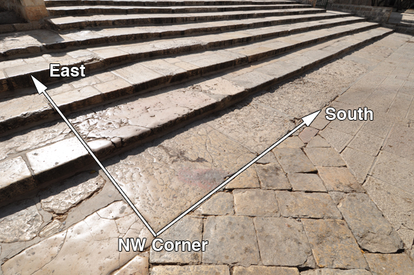
It is difficult to say when this monumental masonry was built, but it is located along the line of the northern wall of the raised platform, which we had previously (The Quest, pp. 165-186) identified as the northern boundary of the pre-Herodian Temple Mount. To the west of this same line is the northwest corner of the 500-cubit square Temple Mount of the First Temple period and we had suggested that this was built by King Hezekiah:

Northwest corner of square Temple Mount, looking southeast. Photo: Nathaniel Ritmeyer

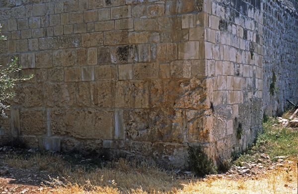
To the east of the newly discovered masonry there are equally large stones to be seen at the northeast corner of the raised platform.

Northeast corner of raised platform showing large ashlars. Photo: Leen Ritmeyer

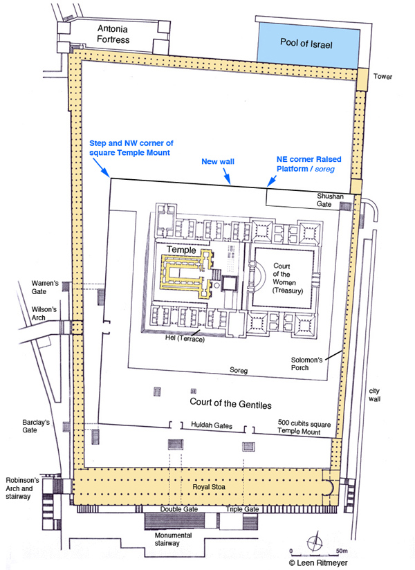
Putting these three points together, we see that all three masonry remains lie on the northern boundary of the ancient square Temple Mount:

Plan of the Herodian Temple Mount with indications of ancient masonry. © Leen Ritmeyer

The masonry at the northwest corner of the square Temple Mount is characterised by rough bosses, while the other two sections have smooth masonry. It is possible that these two sections were built at a later time, above earlier masonry.

Reviewing the discovery of this new wall, we can see that it lies on the northern boundary of the ancient Temple Mount. It is unlikely that this wall was built in the Umayyad period as no other masonry of this calibre can be seen anywhere in the outer walls of the raised platform. No major building projects were carried out on the Temple Mount in the Byzantine period. That leaves us with either the Roman (Aelia Capitolina) or the Herodian period. Although we cannot prove it, the latter would be an exciting possibility! In any case, the fact that monumental masonry is built on the northern boundary of the ancient Temple Mount appears to confirm the location of the square Temple Mount of the First Temple period.

All this goes to show that many more archaeological remains may still be hidden below the surface of the Temple platform and how much more we could learn if excavations were made possible! This would be extremely valuable, as only excavation would make it possible to identify the period of these wall remains.


Kh. el-Maqatir – ‘Joshua’s Ai’ Exhibition

The Associates for Biblical Research announced the opening of an exhibition called: “Khirbet el-Maqatir: The History of a Biblical Site” at the Dunham Bible Museum of Houston Baptist University, January 21st through December, 2014″

Khirbet el-Maqatir: History of a Biblical Site will be a year-long exhibit of 42 artifacts from excavations in Israel at Khirbet el-Maqatir, thought to be the site of ancient Ai from Joshua 7-8.  The Civil Administration for Judea and Samaria has approved the loan of these artifacts for exhibit at the Houston Baptist University’s Dunham Bible Museum from January 21-December 19, 2014.  In conjunction with the exhibit, a symposium will be held on February 8th, focusing on the role of archaeology in understanding ancient history and biblical studies as well, including critical reflection on the excavations at Khirbet el-Maqatir and what light they shed on the ancient biblical world.

This is the program of the symposium:

9 am – Dr. Bryant Wood, “ Khirbet el-Maqatir: A Border Fortress in the Highlands of Canaan and a Proposed New Location for the Ai of Joshua 7-8”

10:15 – Dr. Eugene Merrill, “Ai and Old Testament Chronology: Who Cares?”

11:30-1:00 Lunch Break

1 pm – Dr. Scott Stripling, “Ritual Purity at Khirbet el-Maqatir’s First Century Village and the First Jewish Revolt Against Rome”

2:15 – Dr. Leen Ritmeyer, “Does the Byzantine Church at Maqatir reflect the sacred architecture of the Temple in Jerusalem?

3:30 – Closing panel discussion

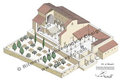
This recently completed reconstruction drawing of the Byzantine Monastery at Kh. el-Maqatir will be part of the exhibition. Drawing: Leen Ritmeyer

Herod’s Tomb at Herodium

Haaretz newspaper carried an article today by Nir Hasson, reporting on the seventh annual conference, “Innovations in Archaeology in Jerusalem and the Surrounding Area”.

During that conference, two archaeologists, Joseph Patrich and Benny Arubas challenged Ehud Netzer’s identification of Herod’s Tomb that was found at Herodium near Bethlehem.

Herod’s tomb  was discovered by Ehud Netzer in 2007, next to a large stairway that gave access to the Upper Palace.
 On the other side, the remains of a theater was found.

They argued that the tomb was too small for the larger than life personality of Herod the Great and that the monument was not in keeping with the size of other Herodian constructions. They also found the sarcophagus, which was made of beautiful red limestone, to be of inferior quality for the king and had expected either a marble or golden one. They also said that the plaza near the tomb was too small to accommodate the many people that accompanied the sarcophagus of Herod the Great.

Patrich emphasizes that he was a student of Ehud Netzer, but that he couldn’t agree with him on the identification of the tomb.

The rebuttal delivered by Roi Porat, who succeeded Netzer as the head of the Herodium excavations, was more positive and convincing. Porat pointed out that there was a very large plaza at the foot of the artificial man-made hill that could easily accommodate the funeral procession. He also noted that the tomb stood on natural ground:

“This whole big mass has one place that was not covered in earth, and that is the site of the tomb,” Porat says. He claims that Herod conceived of the entire tel as an enormous and unique burial mound, symbolizing the idea that life at its top would go on even after the king was buried.”

Porat doesn’t rule out the possibility of finding other tombs, but this one appears from an architectural perspective more than qualify to be the tomb in which Herod the Great was buried.

Porat rightly observed:

“We believe we have a decent picture of what is going on there and it is convincing. We have sufficient data. He [Patrich] deals with what is not, and we with what is”.

That would fit in with my personal experience. Patrich may be proud to have been one of Netzer’s students, but having worked with him on several projects in the past, I must say that I am not too impressed with Patrich’s knowledge of ancient architecture.

Patrich may have expected Herod’s tomb to have been a much larger and more impressive monument, but this exquisitively designed tomb was built for Herod himself and a few close family members only. Patrich and Arubas must have forgotten that a very large funerary monument for Herod’s wider family had already been identified by Ehud Netzer north of Jerusalem:

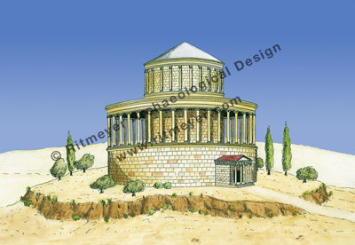
To the north of the Old City of Jerusalem, the remains of a circular building have been discovered and identified with the Monument of King Herod the Great, which served as his family tomb.
Herod was buried in his private tomb in Herodium, both other members of his family were probably buried in this structure. This mausoleum is mentioned twice by Josephus, in War 5.108 and 5.507.

Haaretz may have called the observations of Patrich and Arubas an “archaeological stunner”, but I am not convinced by them. See also Todd Bolen’s blog.

HT: Joseph Lauer

Underground Battle for the Temple Mount

In today’s Makor Rishon (Hebrew) newspaper, Arnon Segal published an article, called Otiot porchot be-avir (letters blossom in the air). Based on the diary of the Rabbi of the Western Wall, Rabbi Meir Yehuda Getz, he retells the story of the underground excavations and the struggle that took place inside Warren’s Gate in 1981. Warren’s Gate is the northern-most of the four original Herodian gateways that gave access to the Temple Mount through the Western Wall.

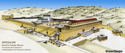
This well-known reconstruction drawing of the Temple Mount in Jerusalem during the Second Temple period is based on historical information and the results of the Temple Mount excavations, which were led by the late Prof. Benjamin Mazar from 1968-’78.
Herod the Great enlarged the existing Temple Mount to double its size and built a new Temple. In the Western Wall (left) there were four gates. Warren’s Gate is the northern-most gate in the Western Wall (on the left). The Southern Wall (right) had two gates. Above this wall stood the Royal Stoa. The Antonia Fortress at the northwest corner (far left) guarded the Temple Mount from the north.

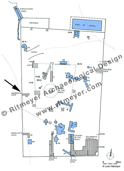
In April 1866, Captain Charles Wilson inspected this underground passageway which for several centuries had been used as a water reservoir. Three years later, Charles Warren examined the cistern (Cistern 30, see below) and noted that its western end pierced the Western Wall. It measures 25.6×5.50m and its floor is 10.50m below the level of the Temple Mount. This cistern was originally a Herodian underground passage, leading up from Warren’s Gate to the Temple Mount, possibly having an internal L-shaped stairway like at Barclay’s Gate. A relatively modern stairway descends from the west into the cistern. Wilson later named this gate after Warren.

This plan shows the cisterns (blue) and underground passageways (grey) of the Temple Mount. The numbering system was developed by Charles Warren, who, in the 1860’s, explored many of these underground structures. Some of these underground passageways were part of Herodian gates that gave access to the Temple Mount, i.e. Cistern 30 is the underground passageway of Warren’s Gate (see arrow), Cisterns 19 and 20 are part of the underground passageway of Barclay’s Gate, Cistern 1 is the underground passageway of the ancient Tadi Gate.
Some of the water cisterns, such as Cisterns 7 and 8 were enormous underground water reservoirs, capable of holding some 2 million gallons of water. Most of these cisterns were initially underground quarries from which building stones for the buildings of the Temple Mount were taken. After the quarrying activities were stopped, these caverns were plastered and became water reservoirs.

This underground tunnel was accidentally rediscovered in 1981 during excavations that took place along the Western Wall north of Wilson’s Arch. During the construction of an underground synagogue, workers broke through the wall that had blocked up the gate opening.

Rabbi Getz believed that this gate was used in the past by priests going up to the Temple. He also believed that this passage led to the lost Temple treasures and to the Ark of the Covenant. After working in secret for about a month, Arabs found out from a media report that the Israelis were excavating below the Temple Mount. They descended into the cistern through two manholes from above and closed off the gate with a very thick concrete wall.

The dream of Getz to reach the Temple Treasures, especially the Ark of the Covenant, was dashed. According to his diary, he sat down with ashes on his forehead, praying:    “O God, the nations have come into your inheritance; they have defiled your holy Temple.” (Psa. 79:1).

Despite the fact that this excavation was illegal, it nevertheless would have been exciting to find out more about how exactly this underground passage originally worked.

HT: Yisrael Medad

Nahman Avigad – Excavator of the Jewish Quarter in Jerusalem

Ha’aretz reports that today, September 25th, is the birthday of the late Prof. Nahman Avigad:

September 25, 1905, is the birthdate of Nahman Avigad, one of the leading members of the first generation of biblical archaeologists in modern Israel. Avigad’s excavations in Jerusalem following the Six-Day War revealed much of the history of the Jewish Quarter of the Second Temple and Byzantine periods; he also interpreted one of the Dead Sea Scrolls and dug at Masada and Beit She’arim, among other places.

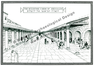
It has been a privilege to have worked with Avigad for over ten years in the Jewish Quarter Excavations of the Old City of Jerusalem, from 1987-1987. He was a very fine scholar having the distinct advantage of being trained in both architecture and archaeology. He let me help him supervise the reconstruction of the Cardo:

It is for his work in the Old City of Jerusalem, where he excavated between 1969 and 1983, that Avigad is best remembered. When the task of finding the Herodian “Upper City” was offered to him, two years after East Jerusalem came under Israeli sovereignty, Avigad was already contemplating retirement. He dug up the Cardo, the Byzantine-era road that linked the Church of the Holy Sepulchre with the Nea Church, and that was previously known by its depiction in the Madaba Map mosaic; the “Broad Wall,” constructed after the return from the Babylonian Exile; and the Iron Age (prior to the 6th century B.C.E.) Israelite Tower. Avigad also found and dug up the so-called Burnt House.

Reconstruction of the Byzantine Cardo. © Leen Ritmeyer

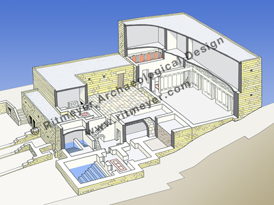
Later on, he put me in charge of the restoration of six magnificent Herodian villas, now located below the Yeshivat Hakotel, the largest of which may have been the palace of Annas the High priest:

Archaeological work proceeded at the same time that the commercial and residential development of the Jewish Quarter was under way, and dictated the pace of that development. As a consequence, however, today there is an archaeological museum underneath Yeshivat Hakotel, which serves as an excellent introduction to life in Second Temple-era Jewish Jerusalem, and a number of other historical sites that can be visited, and that are integrated into the Quarter, among its shops and homes.

The Palatial Mansion – Palace of Annas the High Priest. © Leen Ritmeyer

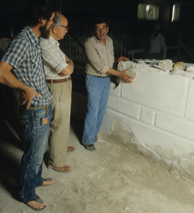
Avigad came twice a week to inspect the work:

David Simon (right) shows the restoration stucco work to Prof. Avigad (middle) and myself.

Avigad will be fondly remembered by many.

Evidence for the Destruction of Jerusalem in 70AD

The Roman destruction of Jerusalem in 70AD, was a tragedy that is still mourned today by many. Josephus Flavius, also known as Yosef Ben Matityahu, was an eye-witness to the siege of Jerusalem. He somehow survived the siege of  Yotvat in Galilee and with one of his soldiers surrendered to the Roman forces in July 67. The Roman forces were led by Flavius Vespasian and his son Titus, both subsequently Roman emperors. In 69, Josephus was released (War 4.622-629) and according to Josephus’s own account, he appears to have played a role as a negotiator with the defenders during the Siege of Jerusalem in 70. After a desperate struggle, the Temple was destroyed, followed by the rest of Jerusalem. Despite the entreaties of Josephus to spare the city, the rebels, as he called them, refused to give up the city and rather fought to the end. Many people died of famine and others, who wanted to save their lives by surrendering to the Romans, were killed by their fellow fighters. There were corpses everywhere. Some of the rebels tried to save their lives by hiding in underground structures:

“A last and cherished hope of the tyrants and their brigand comrades lay in the underground passages, as a place of refuge where they expected no search should be made for them, intending after the complete capture of the city and the departure of the Romans to come forth and make their escape. But this proved to be but a dream: for they were not destined to elude either God or the Romans” (War 6.370, Loeb edition).

Interestingly, as we are leading up to the 9th of Ab (starts in the evening of Monday, July 15th and ends in the evening of the 16th), the date on which the Jews mourn the loss of both their Temples, two discoveries have been announced this week that may cast light on this tragic episode. First, the Israel Antiquities Authority announced the finding of some cooking pots and an oil lamp in an underground cistern near the Western Wall that indicate, according to Eli Shukron, the excavation director, that some people went into the cistern and secretly eat the food that was inside the pots.

Three complete cooking pots and a small ceramic oil lamp were uncovered inside a small cistern in a drainage channel that runs from the Shiloah Pool in the City of David to Robinson’s Arch.
Photograph of the finds in the cistern: Vladimir Naykhin.

And today it was announced that in the Ophel Excavations, directed by Eilat Mazar, a cave, connected to a system of tunnels, was also used as a last hiding place.

“The project archaeologists suggest that the tunnels and shafts may possibly have been made and used by inhabitants of the city hiding or protecting themselves from the Roman siege of Jerusalem during the height of the First Jewish Revolt.”

The area supervisor, Brent Nagtegaal, observes:

“It’s amazing when you look at some of these tunnels … A lot of them are incomplete.”

At a certain location, he speculates:

“This is probably the point at which the Romans broke through or the point at which the Jews realized they could do no more digging, there was no more time and they had to hide themselves.”

In this video, Brent explains the findings:

Brent Nagtegaal

The historical record by Josephus and these recent finds, however sad, have nevertheless given us a deeper and more realistic insight into this tragic event.

HT: Joe Lauer