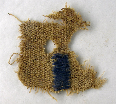
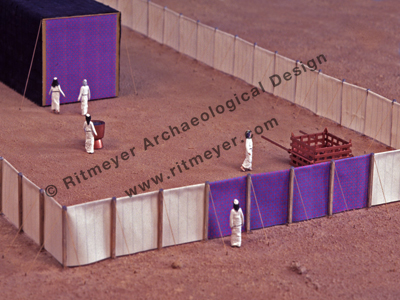
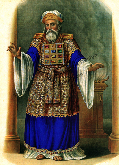
The first known physical sample of tekhelet (the Biblical “blue” that was used in the Tabernacle and the High Priest’s garments) has been identified among finds from Masada. Read the full story here.
HT: Joe Lauer
Ritmeyer Archaeological Design
…for the latest research, analysis and products on Biblical Archaeology
The first known physical sample of tekhelet (the Biblical “blue” that was used in the Tabernacle and the High Priest’s garments) has been identified among finds from Masada. Read the full story here.


HT: Joe Lauer
One month ago, I returned from Tall el-Hammam where, among other things, I studied the EB (Early Bronze Age) gate and its IB (Intermediate Bronze Age) blocking. Dr. Steven Collins is the dig’s director, and this report explains why he thinks that the EB gate was blocked in the IB period.
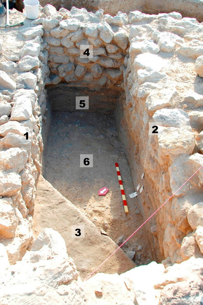
Archaeological work shows that people were living at Tall el-Hammam at least as far back as 6,000 years ago.
By the time the climate disaster hit, nearly 4,200 years ago, the city supported a population of between 15,000 to 25,000 people living in or nearby.
The team believes that it was the centre of a small kingdom ruled by a king. The city certainly had its share of amenities. A 100 meter by 100 meter raised platform served as the main hub of the city, containing temples and administrative buildings.
The city was protected by a massive fortification system with walls that Collins said were “about six meters thick and would have been about three times that high.” These fortifications had somewhere between 15 and 20 gates, giving outsiders access to the settlement.
HT: Jack Sasson
Tom Powers, a well-known Jerusalem based tour guide, commented on my previous post:
This is very helpful for understanding the vaulted vs. slabbed sections of the drain channel, which I had not grasped before (the latter is what is seen in the now-open section in Silwan). So, it seems the Herodian vaulted section is relatively short — a “bypass” around the SW corner of the Temple Mount — and that most of the length of the drain is actually Hasmonean, yes?
I though that my reply may be interesting to others as well.
That’s right, Tom. The Hasmonean section continued to the south, but also to the north of the Herodian “by-pass”. There is, however, another more ancient drain some 20 meters to the east of the present southwest corner of the Temple Mount. On the map below I plotted the two drains together with the respective southwest corners of three phases in the development of the Temple Mount.

The early (possibly First Temple period) eastern drain follows the Tyropoeon Valley and passes the southwest corner of the square Temple Mount (yellow) to the west. This drain appears to be contemporary with the square Temple Mount, which dates from the time of Hezekiah.
The southwest corner of the Hasmonean extension of the Temple Mount (orange) cut this early drain and a new drain with flat covering stones was constructed to the west of this corner. We need to remember that drains usually ran below streets and therefore these drains are important indicators of the city plan in the different periods.
The Herodian southwest corner (green) cut this Hasmonean drain and a vaulted “by-pass” was created to connect the two severed sections of the Hasmonean drain. This by-pass was constructed while Robinson’s Arch was built, for two arch stones fell on the open drain and were left there by the builders.
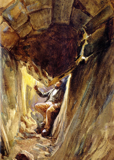
The vaults were built up against and slightly over the arch stones, which were then covered up quickly, I suppose, before the inspectors discovered what had happened!
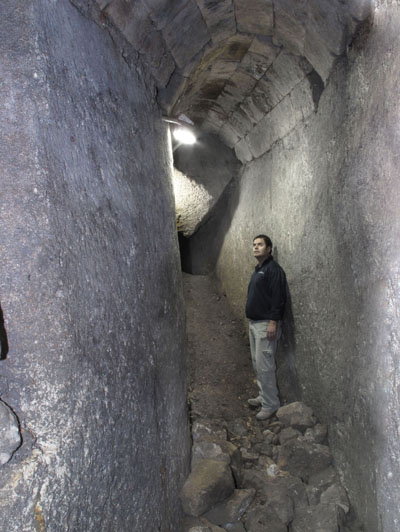
Here is a modern picture with the same fallen arch stone in the background.
The State Comptroller has prepared a report on the wanton destruction caused by the Waqf on the Temple Mount, and on Israel’s response. The Committee to Prevent Destruction of Temple Mount Antiquities is up in arms that the lion’s share of the report will not be publicized.
Read the rest of today’s Israel National News report here.
You can read some of our earlier posts on this issue here.
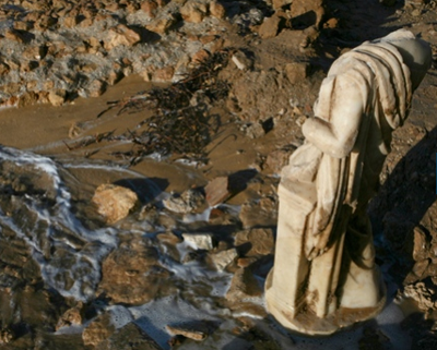
It doesn’t often happen that the weather helps archaeologists. Haaretz reported that a massive storm caused a collapse along the Ashkelon coast and revealed a statue of a headless woman. The report also has a slide show of the discovery.
The massive storm that swept through Israel over the weekend caused a great deal of damage to archaeological sites all along the Mediterranean coast, but also uncovered a an impressive statue of a woman between 1650 and 1800 years old in Ashkelon.
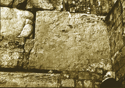
One of the readers of a previous post drew attention to a Palestine Exploration Fund (PEF) photograph of the lintel of Barclay’s Gate. In the caption, we are taken to task for publishing an incorrect interpretation of the lintel in BAR XV No.6, pages 23-42.
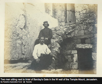
We wrote the following comment below this photograph:
The incorrect black outline on the photograph on p. 28 of the BAR issue was unfortunately added by the editors and not by ourselves. For the correct drawings of the lintel of Barclay’s Gate, see our book The Quest, Revealing the Temple Mount in Jerusalem, pp. 26, 28.
Whoever put up this caption didn’t look carefully at the drawing next to the photograph in the BAR issue, where the lintel is drawn correctly.
Barclay’s Gate is one of the four gates in the Western Wall of the Herodian Temple Mount:
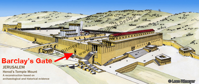
This study drawing shows the depth of the original gate, which is still buried underground:

This close-up photograph shows that the projection on the left side of the lintel is not very sizeable:
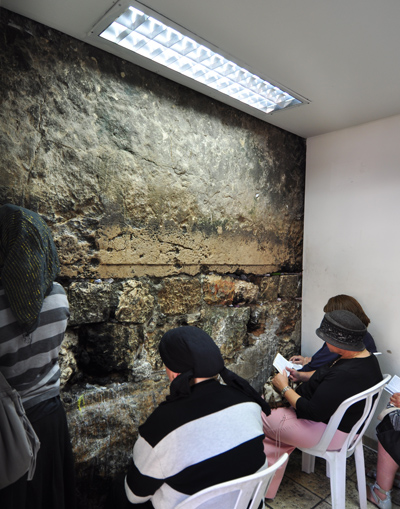
A central part of the lintel can be seen in the small room where women pray:
Here is a view of the same lintel from inside the Temple Mount:
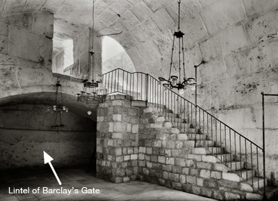
Barclay’s Gate is one of the two lower gates in the Western Wall, the other is Warren’s Gate. Both these gates had internal passageways with steps by which one could ascend to the Temple Mount. This reconstruction drawing shows how Barclay’s Gate worked in the Second Temple period:
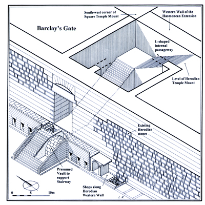
If the new plans for the Western Wall plaza were carried out, the full size of this gate would be visible to all.
If you are in Israel and interested in the Middle Bronze Age, you wouldn’t want to miss this conference:
Below is the program for the upcoming Middle Bronze Age Study Group,
which will be held on December 23rd, 2010, at the University of Haifa.
We, the organizers, would love to see you at the meeting.The Middle Bronze Age Study Group
The 2010 WorkshopPatrician and Palatial:
The Middle Bronze Age Sites of Tel Ifshar and Tel Kabri”Thursday, December 23rd, 2010
Leon Recanati Institute of Maritime Studies
University of Haifa, Multi-purpose Building, Room 108
(Lectures will be in English)9:00 – Gathering
9:30-9:40 – Dr. Yaacov Kahanov, Director, Recanati Institute of
Maritime Studies: GreetingsLecture Session: 9:30 – 12:00
Chair: Prof. Aren Maeir
9:40-10:20 – Dr. Ezra Marcus and Dr. Yosef Porath: The Middle Bronze
Age IIa sequence of Tel Ifshar and its relative and absolute
chronology.
10:20-11:00 – Dr. Assaf Yasur-Landau and Prof. Eric H. Cline: The
Middle Bronze Age I (IIa) and II (IIb) palace at Tel Kabri
11:00-11:20 – Prof. Manfred Bietak: Respondent
11:20-12:00 – Discussion12:00-13:00 – Lunch break
Pottery Session: 13:00 – 15:00
Tel Ifshar: Dr. Ezra Marcus
Tel Kabri: Ms. Inbal Samet
Tel Esur/el-Assawir: Dr. Shai Bar and Assaf Bar-HadasIn order to provide ample room to accommodate all those attending for
the morning session, the organizers kindly request that you RSVP,
including car plate number (if you wish to park within the Haifa
campus) by December 15 to either assafyasur@hotmail.com or
ezra@research.haifa.ac.il.David Ilan, Aren Maeir, Ezra Marcus, Joe Uziel and Assaf Yasur-Landau
Organizing Committee
HT: Jack Sasson
Shimon Gibson, a co-director of the dig on Mount Zion, has launched a fund-raising drive for work on the finds from excavations conducted in the area in the 1970’s.
More than thirty years ago major archaeological excavations were conducted on Mount Zion in Jerusalem, with the discovery of the remains of King Herod’s palace, well preserved first-century houses, and rich artefacts. But the results of this work were never fully published. The archaeologist Shimon Gibson because of his professional interest in ancient Jerusalem, decided a decade or so ago to take on the responsibility of publishing these excavations. It was only a year ago that the finds, plans and field notes that had been presumed to be lost were unexpectedly discovered. This presented him with the daunting task of having to deal with enormous quantities of material, much of it in a very bad state of preservation owing to the substandard storage conditions they had been kept in. He has been battling this past year to raise funds for work on these amazing artefacts and this has now led him to publish an appeal for funding on the internet. Have a look at the site.
HT: Alexander Schick
This report was in the San Diego news a couple of days ago:
Thomas Levy, a UCSD professor of anthropology and Judaic studies, has
pioneered three highly sophisticated digging excavations in an area
called Khirbat en-Nahas, located in southern Jordan, attracting the
attention of NOVA/National Geographic Television, which sent a crew to
Jordan with him last fall.Levy, also the associate director of the Center of Interdisciplinary
Science for Art, Architecture and Archaeology (CISA3), wasn’t looking
for King Solomon’s mines at first. He was actually researching the
role of ancient technology on the evolution of society. But what he
found in Jordan was groundbreaking — thousands of tons of slag, a
by-product of smelting ore, and different types of blowpipes. Using
the process of radiocarbon dating, his team discovered there was
industrial-scale metal production of copper precisely in 10th century
BC.
“It would have been like the Pittsburg of Palestine,” said Levy.There are two sides to the King Solomon debate, he said. First, there
are those who “minimize the historicity of the Old Testament, saying
there was no Solomon because during the 10th century there were no
societies capable of creating a kingdom, only petty nomads.” On the
other side, there are those who maximize the content of the Old
Testament, he said.“We don’t have proof that we have found Solomon’s mines, but what we
have proof of is that there were kingdoms in the 10th century,” said
Levy. “I think he existed.”
You can see a preview of the movie here:
HT: Jack Sasson
Update: The “Quest for Solomon’s Mines” is being streamed (53 minutes) at PBS, but in the UK you can’t see it, for a message says: “We’re sorry, but this video is not available in your region due to rights restrictions.” Sad …
The discovery of the remains of a bathing pool that may have belonged to a Roman bathhouse has been widely reported. I read about it first in the Jerusalem Post. The original announcement was made by the IAA (Israel Antiquities Authority). Here is a link to the pictures.
The dig is located in 10 Haomer Street in the Jewish Quarter of the Old City of Jerusalem, which is north of the Burnt House and east of the Broad Wall.
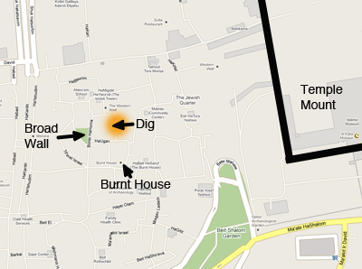
The announcement of the discovery came at a time when I was preparing to add a reconstruction drawing of Aelia Capitolina to our new Image Library. It gave me the opportunity to add the newly discovered bath house to this drawing:
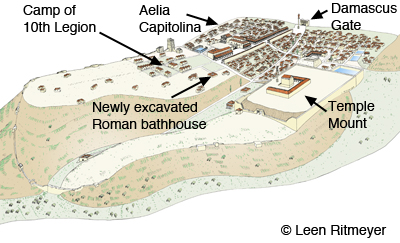
The drawing illustrates the comments of Yuval Baruch, who noted:
the importance of the discovery, which sheds light on the study of post-destruction Jerusalem.
“Despite the very extensive archaeological excavations that were carried out in the Jewish Quarter, so far not even one building has been discovered there that belonged to the Roman legion,” he said.
“The absence of such a find led to the conclusion that Aelia Capitolina, the Roman city which was established after the destruction of Jerusalem, was small and limited in area.”
“The new find, together with other discoveries of recent years, shows that the city was considerably larger than what we previously estimated. Information about Aelia Capitolina is extremely valuable and can contribute greatly to research on Jerusalem because it was that city that determined the character and general appearance of ancient Jerusalem and as we know it today. The shape of the city has determined the outline of its walls and the location of the gates to this very day.