National Geographic’s The Holy Land Special Issue

While we were in the US, we noticed a special November 2009 issue of the National Geographic on The Holy Land.

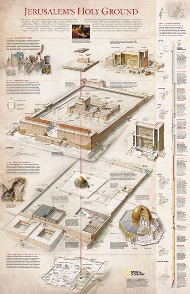
It has many interesting articles about the Holy Land, but it also has a previously published poster of the Temple Mount as an insert. We described this poster, of which we were one of the contributors, in this previous blog post. Many readers asked for copies of this map and we are delighted to announce that it is still available inside this special issue.

If you don’t have a subscription to the National Geographic, you can order this special issue here.

Here is a view of the poster, reproduced with permission of the National Geographic Society:

Conferences and Lectures in New Orleans

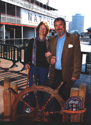
My wife Kathleen and I enjoyed our time last week in New Orleans and even had time to sail on the Mississippi on the Steamboat Natchez. It was also interesting to listen to the many stories about the Katrina disaster four years ago. People’s lives are still dominated by that event. Their recent history seems to be divided in pre- and post-Katrina periods. The New Orleans Baptist Theological Seminary, where I lectured for two days as the Manuel Lectureship Speaker, is only now getting back to normal, after having had to move to Atlanta, as most of the campus was flooded.

natchezweb

There were many lectures to choose from at the ASOR, ETS, SBL and NEAS conferences. We attended lectures, ranging from Satellite Remote Sensing, the Location of Sodom, through the latest updates of recent archaeological excavations, such as Kh. Qeiyafa and Tell Es-Safi/Gath, to a fascinating section on Teaching Archaeology.

The latter section was at times hilarious, listening to archaeologists who had to teach archaeology, without having had any prior teacher training, to students who didn’t know anything about the subject at all. Reading assignments sometimes produced gems like the title of Eric Cline’s lecture: “The Israelites Wondered in the Dessert for 40 years” and “Before the Printing Press, it took 300 Sheep to Write the Bible”.

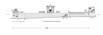
Here is a comment on my lecture on “The Eastern Wall of the Temple Mount in Jerusalem – Deciphering Its Story”.

Lectures by Dr. Leen Ritmeyer

On Nov. 15th and 16th, I have been invited by Dr. Dennis Cole to lecture at the New Orleans Baptist Theological Seminary on two topics:
• The History and Archaeology of the Temple Mount in Jerusalem.
• The History and Archaeology of Herodian Jerusalem.

On Nov. 18th, 9.00 am, I am scheduled to deliver a lecture for ASOR (American Schools of Oriental Research), also in New Orleans, on:
• The Eastern Wall of the Temple Mount – Deciphering its Story.

The Eastern Wall is the most interesting of all the Temple Mount walls, as three types of masonry can be discerned: Herodian, Hasmonean and Iron Age (8th Century B.C.). These masonry types are directly linked with the historical development of the Temple Mount.
EastWallBlog

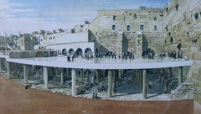
New excavations planned below the Western Wall Plaza

According to this report, new excavations are planned below the Western Wall Plaza. The present level would be supported by pillars and an additional underground area would be available for worship/visiting. Here is an artist’s impression:
kotel_dig

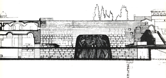
This is not a new idea, for already in 1967 plans were drawn up to excavate below this area. The plan called for an excavated area below ground level, but also retaining the level of the plaza as it was then:
kotel1967-12

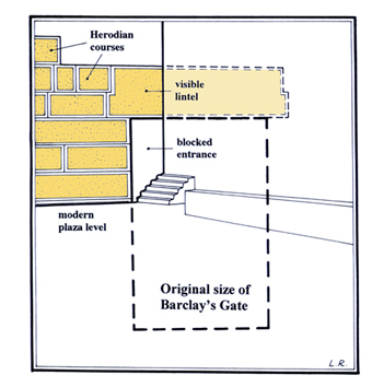
It would be fascinating to see more of the Western Wall in this area and also to see Barclay’s Gate to its full height. This drawing shows the visible remains of Barclay’s Gate above ground today and the original size of the gate:
fig12blog
(This drawing was published in The Quest, p.26)

Coins from ancient Jewish revolt found near Temple Mount on display

AP reported that an interesting collection of coins, which was found below the Herodian street along the Western Wall of the Temple Mount, is on display at the Davidson Centre. One coin, with a date palm portrayed on it, dates from one year before the Roman destruction of Jerusalem.

A peek into excavations near the Temple Mount

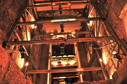
Just over a week ago I led a tour through the Western Wall tunnels and saw some very deep excavations between the foundations of buildings which date from the Mamluk period (14th-15th Century AD). Excavations are continuing until bedrock is reached. Several mikva’ot (Jewish ritual baths) from the Second Temple period were observed – an indication that Jerusalem was indeed Jewish at the time. Here is a picture I took of one of the deepest excavation pits:

WWHFdig

Joe Lauer sent me this report, showing that not everybody is happy with the excavations. The title of the article is misleading, as no excavations are conducted inside the Temple Mount. The Muslim claim that tunnels are dug within the Temple Mount are not true. The whole area lies to the west of the Temple Mount. An invitation to tour the area was turned down by Muslims. How can one reach understanding when dialogue is refused?

New Discoveries Related to Temple Mount

Todd Bolen’s blog post gives an excellent overview of discoveries related to the Temple Mount. Worth reading!

“Hall of Ages” near the Temple Mount rehabilitated

Despite the fact that this building has been known for several decades, only now has it been possible to restore it using modern techniques:
“Although the new hall was originally discovered decades ago, it lay untouched for years due to fears that the ancient stones were not stable enough for excavation. A new technique was found to support the walls from crumbling, enabling workers to remove the rubble.”
Artifacts from both the First and the Second Temple periods were found. The name given to this building, “Hall of Ages” (or “Hall of Eras”), is a bit ridiculous, as remains of these periods have been found in many other sites in Jerusalem.
Within a few months it will be opened to the public. I look forward to discovering where this building is actually located. I guess it is part of the old Makhkama building shown on the plans of Charles Warren. If so, it should be located near the Masonic Hall, mentioned in my previous post, and Wilson’s Arch.
For full story, see the Jerusalem Post’s article here.
Satellite
Photo: Channel 2

Source: Joe Lauer

A 2,000 year old Mikveh exposed in the Western Wall tunnels

While I was abroad, the IAA reported that a 2,000 year old mikveh has been found near the Temple Mount:

“The miqve was discovered inside the western hall of a splendid structure that is located just c. 20 meters from the Western Wall. Parts of the building were discovered in the past and the Israel Antiquities Authority is currently exposing another one of the three halls inside it. It is one of the most magnificent structures from the Second Temple period ever to be uncovered.”

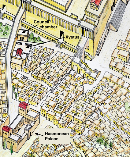
This “magnificent structure” is the Council-chamber, also known as the Masonic Hall, which was first discovered by Charles Warren in the 1860’s. It is located near the Western Wall and the bridge over Wilson’s Arch was later partly built over it. This drawing shows the location of the Council-chamber, the Xystus and the Hasmonean Palace in relation to the Temple Mount:
Xystus

The confusing part in the rest of this report is the following sentence:

“In his book The War of the Jews, Josephus Flavius writes there was a government administrative center that was situated at the foot of the Temple. Among the buildings he points out in this region were the council house and the “Xistus”- the ashlar bureau. According to the Talmud it was in this bureau that the Sanhedrin – the Jewish high court at the time of the Second Temple – would convene. It may be that the superb structure the Israel Antiquities Authority is presently uncovering belonged to one of these two buildings.”

Josephus actually writes the following about the northern part of the First Wall in The War of the Jews 5.144:
“Beginning on the north at the tower called Hippicus, it [the city wall] extended to the Xystus, and then joining the council-chamber terminated at the western portico of the temple.”

The Xystus was not a building, but a paved open space for assembly, used for public speeches. In Greek, xystus means smooth, polished flag-stones. Previously, the Gymnasium was located there. In The War of the Jews 2.344, Berenice stood watching on the roof of the Hasmonean Palace, while King Agrippa made a speech to the people which he had summoned to the Xystus below. If they were inside a building, Berenice could never have watched this event. It is therefore a mistake to confuse the Xystus with the “ashlar bureau”, better known as the Chamber of Hewn Stone (Lishkat haGazit in Hebrew) of the Mishnah.

The Council-chamber (Bouleh in Greek) was located between the Xystus and the Western Wall of the Temple Mount. It was a public building and has nothing to do with the Chamber of Hewn Stone, which was located on the Temple Mount. It is described in Mishnah Middot 5.4 as one of the chambers of the Temple Court: “Those [chambers] on the south were the Wood Chamber, the Golah Chamber and the Chamber of Hewn Stone.” “The Chamber of Hewn Stone – there used the Great Sanhedrin of Israel to sit and judge the priesthood.” See also my previous post on The Sanhedrin and the Temple Mount.

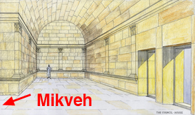
The archaeologist Alexander Onn correctly calls the Council-chamber a government administrative building. The mikveh with its 11 steps was built later into the building, testifying to the growth and development of Jerusalem later on in the Herodian period.

The Council-Chamber was a beautifully designed building with pilasters cut into the interior walls, resting on a plinth which was located about 1 meter (3 feet) above the original floor. The newly discovered mikveh is located in the western hall of this building, well below the original floor level. Below is my reconstruction drawing, showing the location of the mikveh:
mikvehtn

Jerusalem unveils road used by pilgrims during Second Temple

In my previous post I reported inaccurately that the newly revealed street was located east of the Siloam Pool, while, in fact, it is the main Herodian street to the west. Sections of this street had been excavated previously by Bliss and Dickie, Hamilton and Kathleen Kenyon.
180_rehov_medurag
Photo: Vladimir Neichin