It has been reported that two seals have been found in the Givati Parking Lot excavations, bearing the names of a man and a woman, respectively “Sa‘aryahu ben Shabenyahu” and “Elihana bat Gael”. Their names are not mentioned in the Bible.
Seal of Sa‘aryahu ben ShabenyahuSeal of Elihana bat Gael
Seals with names of women are pretty rare, so she must have been an influential person. The excavators date the finds to about 2,600 years ago, but, we would agree with Todd Bolen, who suspects that the date is closer to 700-600 BC, i.e. the end of the First Temple period.
According to archaeologists, Dr. Doron Ben-Ami, Yana Tchekhanovets and Salome Cohen, excavation directors on behalf of the Israel Antiquities Authority, explain, “Personal seals, such as those of Elihana and Sa‘aryahu, were used for signing documents, and were frequently inlaid as part of a ring that was worn by the owner. In antiquity they designated the identity, genealogy and status of the owner of the seal”.
On the rare woman’s seal, which is made of semi-precious stone, appears the mirror-writing of “to Elihana bat Gael”, inscribed in ancient Hebrew letters. The female owner of the ring is mentioned here together with the name of her father.
According to Dr. Hagai Misgav of Hebrew University in Jerusalem, “Seals that belonged to women represent just a very small proportion of all the seals that have been discovered to date. This is because of the generally inferior economic status of women, apart from extraordinary instances such as this. Indeed, the name Elihana does not appear in the Bible, and there is no other information regarding the identity of the woman, but the fact that she possessed a seal demonstrates her high social status”. Dr. Misgav adds, “Most of the women’s seal that are known to us bear the name of the father rather than that of the husband.
These excavations claimed earlier to have found the remains of the Akra Fortress, which, however, may have belonged to the city’s fortification walls and not to the Fortress by the same name.
Mount Moriah — the Mountain of the LORD. More than 4,000 years of recorded history have been played out on that particular spot, a location specifically chosen by God to accomplish His sovereign purposes. I have often tried to contemplate all that has happened there. The works of God are so overwhelmingly incomprehensible!
This video short will help you to ponder how the God of the Bible, through an amazing chain of historical events, transformed a lowly hill into what is today one of the most revered places on earth!
Another video explains the Topography of Jerusalem in a simple but effective way:
As a visual aid, we’ve developed a simple 3D model to help you picture the ridges, valleys and hills which have changed very little over several thousand years and which are the landscapes for the stories of Abraham and Isaac, King David and Christ.
Enjoy watching these videos which you can also download for a few dollars.
HT: Facebook page of Associates for Biblical Research.
Daniel Smith creates religious themed videos with the purpose of helping people better understand the history and culture of the Bible. You can see several of his videos on his website called Messages of Christ.
He contacted me saying that he read of Solomon’s Temple in my book The Quest. He has now completed a 3D reconstruction of Solomon’s Temple in which he used my design of the interior walls.
Portions of 1 Kings 6 and 7 are read as you look around the video. Although I don’t agree with some of the details, the video is well worth watching.
We have earlier reported on this spectacular movie of Jerusalem here, here and here. We are delighted to announce that it is now available in HD on YouTube. This is your chance (for as long as it lasts) to view it for free and download it.
Last year, a new church building was constructed in São Paulo, Brazil, by the Universal Church of the Kingdom of God.
It is claimed that the design is based on Solomon’s Temple in Jerusalem, “but with increased dimensions”. It certainly is an impressive building, but it is hard to see a real comparison with Solomon’s Temple, which was much smaller and relatively tall. This new building serves as a church and has many rooms and even apartments, while Solomon’s Temple only had two rooms:
A reconstruction drawing of Solomon’s Temple, based on archaeological evidence and the description in 1 Kings 6. The Holy of Holies is placed on the Rock, which is actually the top of Mount Moriah and visible inside the Islamic Dome of the Rock. A special emplacement was cut in the rock for the Ark of the Covenant (1 Kings 8.6,21). The Altar stands in the threshing floor of Araunah, where David had previously built an altar (2 Sam. 24:18; 1Chr. 21:18).
The exterior of this new building looks squat and hasn’t got the elegance of Solomon’s Temple in Jerusalem. Nevertheless, it is interesting to see how the Ark of the Covenant is brought in, properly covered with a blue cloth, and all the other instruments. There also is a model of the Tabernacle. Here is a video:
The Temple serves as both a house of worship and as world headquarters for the Church. The mega-church seats 10,000 worshipers and stands 55 meters (180′) tall, the height of an 18-story building. Its dimensions therefore far exceed the temple it replicates, described in the Bible as having the relatively modest height of some thirteen meters (“thirty cubits”, 1 Kings 6:2).
The majority of the temple space is devoted to the main sanctuary. The sanctuary is lined with pews imported from Spain, which face the main altar. The sanctuary has a conveyor belt system designed to carry tithes and offerings from the altar directly into a safe room. The main ceiling is adorned with 10,000 LED light bulbs which will form different patterns designed to look like stars. Keeping with the Jewish theme of the temple, the walls are adorned with menorahs, and the entrance features a large central menorah.
The church spared no expense in designing the many other features of the temple. Aside from the main sanctuary, the temple also has 36 rooms for children’s Bible school, with a capacity of about 1,300 children, radio and television studios, a museum about the original temple, and 84 apartments of differing sizes for bishops and pastors of the church. The 11-story complex includes outdoor features such as a helicopter landing pad, a garden of olive trees based on the Garden of Gethsemane near Jerusalem, and flags of several countries. There is a parking lot able to accommodate 1,000 vehicles and 50 buses, classrooms for 1,300 children, and radio and television studios inside the building.
One of the most prominent features of the temple is its large central altar. It features an exact replica of the Ark of the Covenant, built to the specifications described in the Book of Exodus. The structure is entirely covered in gold leaf. Behind the ark is the temple’s baptistry, above the altar is 100 square meters of gold stained glass windows, and an inscription “Holiness to the Lord”.
The temple construction cost $300m and took four years to build.
Visiting the Temple Mount can be a frustating experience nowadays with Muslims protesting against the presence of Jews and other non-Muslim visitors. However, there are resources, such as our own guide book to the Temple Mount, and now a new DVD with lots of information on the Temple Mount that make it possible to visit the Temple Mount in a virtual way without all the hassle one could encounter in real time.
Randall Price, the presenter, wrote the following:
With over four years of production time, this new product offers a guided tour of the biblical, archaeological and historical sites on the Temple Mount as well as other parts of Jerusalem, the site of the Tabernacle at Shiloh, and the full-scale model of the Tabernacle at Timna Park.
With over 100 high-definition 360-degree panoramas and informative videos, the user is transported to the modern sites to explore for themselves the ancient biblical and historical connections. Maps are available to guide to the desired modern sites, which show reconstructions of the ancient Temple based on the work of Dr. Leen Ritmeyer. Dr. Randall Price, author of the Rose Guide to the Temple provides the on location video instruction.
The product is available in four languages (English, German, Spanish, and Portuguese) on a single DVD-ROM for both PC and MAC.
Because Islamic officials deny the existence of the Temple at the Temple Mount and prevent visitors from explaining the biblical significance or showing diagrams or pictures of the ancient Temple, this new product corrects this situation in an educational and entertaining way.
European customers can order the DVD here, while American and Canadian orders can be placed on this website.
In the latest Biblical Archaeology Review (Jan./Feb. 2016), Peter Schertz and Steven Fine wrote an interesting article called “A Temple’s Golden Anniversary”. The anniversary they refer to is that of the well-known model of Jerusalem in the Second Temple period that at present is located in the Israel Museum and will be 50 years old in 2016.
Avi-Yonah’s model of Jerusalem in the Second Temple period, Photo: Leen Ritmeyer
In 1966, Prof. Avi-Yonah completed a 4-year project of creating a model of Second Temple Jerusalem built to a scale of 1:50. It was commissioned by Hans Kroch, owner of the Holyland Hotel, in memory of his son Jacob, who was killed in the 1948 Arab-Israeli War. In 2006 the model was dismantled and rebuilt in the grounds of the Israel Museum in Jerusalem. This model and especially the section that depicts the Temple became so popular that it became “the standard image of the Second Temple for Jews and Christians alike.”
The authors describe the Temple complex in great detail and show that Avi-Yonah, in his research for this model, used the descriptions by Josephus, contemporary architectural styles, such as that of the Tomb of the Patriarchs in Hebron and other sites, and depictions on coins, such as those issued during the Bar Kochba Revolt (133-135 AD) that show a Temple façade with a flat roof supported by four columns.
A silver tetradrachm of the Bar Kokhba period, showing the Temple façade with four columns and a flat roof. (Wikipedia)
In the article however, there is a strong focus on the gold of Herod’s Temple:
“How much gold decorated the Temple is also a matter of debate. Josephus describes the Temple façade as covered with ‘massive plates of gold’ and writes that a large golden vine hung with golden fruit above the large door leading to the inner sanctum. … Avi-Yonah took a rather conservative stance toward gold, using it for external trim, but not as a facing for the Temple, nor did he include the golden vine in his reconstruction.”
In their article, the authors contrasted Avi-Yonah’s model with the one I designed for the late Benjamin Adelman, Chairman of the American Friends of the Israel Exploration Society in Washington DC. His commission of several models was a wonderful opportunity to put my personal research of many years of study of Jerusalem and the Temple Mount into elegant models of Herod’s Temple, Herod’s Temple Mount, Solomon’s Temple and the Tabernacle. These models were produced in England by a professional modelmaking firm, York Modelmaking and Display Limited and shipped over to Washington. After Adelman’s death, these models were bequeathed to the Yeshiva University Museum in New York.
The authors wrote of my model of Herod’s Temple:
“In contrast to Avi-Yonah, Leen Ritmeyer, the former architect of the archaeological excavations below the Temple Mount, has taken a rather maximalist approach to the Temple gold. His model … covers the entire façade with sheets of gold.”
The golden façade of Herod’s Temple with white columns and entablature, based on the description by Josephus and other historical sourcesThe Golden Vine was one of the most remarkable in all the Temple precincts. Middot records that “A golden vine stood over the entrance to the sanctuary, trained over posts; and whosoever gave a leaf, or a berry, or a cluster as a freewill-offering, he brought it and the priests hung it thereon.” This vine was so famous that even Tacitus (History 5.5) wrote about it. While keeping the Passover in Jerusalem, Christ may also have alluded to this very feature of the Temple when he said in John 15. 1: “I am the true vine.”
The authors are unsure of which areas were covered with gold and suggest that the description of the Temple by Josephus (see below) is somewhat obscure:
The sacred edifice itself, the holy Temple, in the central position, was approached by a flight of twelve steps. The façade was of equal height and breadth, each being a hundred cubits; but the building behind was narrower … The entire façade was covered with gold, and though it the first edifice [the Sanctuary beyond the Porch] was visible to a spectator without in all its grandeur and the surroundings of the inner gate all gleaming with gold fell beneath his eye …The gate opening … had, moreover, above it those golden vines, from which depended grape clusters as tall as a man; and it had golden doors … The exterior of the building wanted nothing that could astound either mind or eye. For, being covered on all sides with massive plates of gold, the sun was no sooner up than it radiated so fiery a flash that persons straining to look at it were compelled to avert their eyes, as from the solar rays. To approaching strangers it appeared from a distance like a snow-clad mountain; for all that was not overlaid with gold was of the purest white. From its summit protruded sharp golden spikes to prevent birds from settling upon them and polluting the roof. (War 5.207–226 and also Ant. 15.391-395)
From this description one gets the impression that most of the façade was covered with gold, apart from the upper part. To reduce the enormous amount of gold that the use of massive plates would require, it is more likely that a thin gold foil may have been pressed against the stones and the edges tucked in between them. Remains of thin gold foil have been found in other buildings from that period. We know that the top part of the Temple façade, called the entablature, was not covered with gold, because other sources indicate that the exposed limestone blocks were whitewashed once a year. This would confirm Josephus’ description of the Temple facade as a snow-clad mountain.
Josephus is not the only source describing the gold of the Temple. Mishnah Shekalim 4.4 mentions that the surplus of the terumah was used to make “golden plating for bedecking the Holy of Holies.” The terumah was originally a heave-offering of agricultural produce, but is used here as a financial contribution which was taken three times a year and put in the Chamber of the Half-shekel of the Temple. It appears that if enough money was available, golden plates of one cubit square were made and hung on the walls of the Sanctuary, as Middot 4.1 says that “all the House was overlaid with gold.” Some of these plates were put on display during the three main pilgrim festivals.
Another historical reference to the gold of the Temple is to be found in the New Testament (Matt. 23:16,17) where Jesus berates the Pharisees and Scribes who said: “Whosoever shall swear by the temple, it is nothing; but whosoever shall swear by the gold of the temple, he is a debtor!” Jesus reasons that the Temple that sanctified the gold was greater than the gold itself. It appears therefore that the gold of the Temple was well known at that time.
Finally, as mentioned in a previous post, an inscription in Rome suggests that the gold of the Jerusalem Temple was used for the building of the Colosseum. The Colosseum is a very large building and lots of money, in the form of silver and gold, would have been needed for its construction.
We will never know for sure how much gold the Jerusalem Temple contained and exactly where it was displayed, internally and externally. It is generally known that Josephus occasionally exaggerates, but that a large amount of gold was displayed in the Jerusalem Temple, appears to be a reasonable suggestion if we also take other historical sources into consideration.
The Hebrew University in Jerusalem announced today that in 2009, a bulla (clay impression of a seal) was found in the Ophel excavations bearing the name of King Hezekiah. The seal impression was found during the wet-sifting of earth layers from the Ophel excavation at the Temple Mount Sifting Project.
A seal impression of King Hezekiah unearthed in the Ophel excavations at the foot of the southern wall of the Temple Mount, conducted by the Hebrew University of Jerusalem’s Institute of Archaeology under the direction of Dr. Eilat Mazar. (Courtesy of Dr. Eilat Mazar; Photo by Ouria Tadmor)
The Ophel excavations at the foot of the southern wall of the Temple Mount, conducted by the Hebrew University of Jerusalem’s Institute of Archaeologyunder the direction of Dr. Eilat Mazar, have unearthed an impression of the royal seal of King Hezekiah (727–698 BCE).
Measuring 9.7 X 8.6 mm, the oval impression was imprinted on a 3 mm thick soft bulla (piece of inscribed clay) measuring 13 X 12 mm. Around the impression is the depression left by the frame of the ring in which the seal was set.
The impression bears an inscription in ancient Hebrew script:
“לחזקיהו [בן] אחז מלך יהדה”
“Belonging to Hezekiah [son of] Ahaz king of Judah”
and a two-winged sun, with wings turned downward, flanked by two ankh symbols symbolizing life.
Eilat Mazar eplains the significance of this find in this video. Seal impressions of this famous king who is described in the Bible as “”there was none like him among all the kings of Judah” (2 Kings 18:5)”, have been found earlier, but not in the context of a scientifically run excavation.
The seal was found in debris outside the eastern part of the so-called Royal Structure and was discarded probably through one of the windows of the building. This area is familiar to me as I was initially put in charge of its excavation by the late Prof. Benjamin Mazar and excavated remains of an Herodian building. The Iron Age remains were found below this level.
Prof. Benjamin Mazar (centre with red hat) and myself (left) discussing the excavations in the Opel area. Remains of the Herodian buildings can be seen on the left.
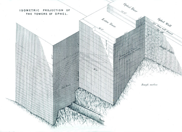
The place where the seal was found is close to a large tower that was apparently added to the existing fortifications by King Hezekiah. Warren dubbed this tower the Extra Tower.
Warrren’s drawing of the Extra Tower. The seal was found to the right of the image.
Kathleen Kenyon also excavated here in the 1960’s and uncovered the remains of this structure in her Area SII. This fortification of Jerusalem was part of Hezekiah’s expansion of the city.
Many other building works of Hezekiah have been uncovered in the Jerusalem excavations, such as the Broad Wall in the Jewish Quarter of the Old City of Jerusalem. This wall is referred to in Isa. 22.10 and was part of the new city walls that Hezekiah built around the previously unprotected Western Hill.
During the reign of King Hezekiah, many refugees from the Assyrian invasion of the northern tribes came to Jerusalem for protection. As the city on the Eastern Hill was too small to accommodate the new comers, they settled on the Western Hill. Eventually, King Hezekiah built a new city wall around this hill to protect it from invasion.
The article of the Hebrew University gives a fascinating insight into the significance of the change in King Hezekiah’s personal symbols:
The symbols on the seal impression from the Ophel suggest that they were made late in his life, when both the Royal administrative authority and the King’s personal symbols changed from the winged scarab (dung beetle)—the symbol of power and rule that had been familiar throughout the Ancient Near East, to that of the winged sun—a motif that proclaimed God’s protection, which gave the regime its legitimacy and power, also widespread throughout the Ancient Near East and used by the Assyrian Kings.
This change most likely reflected both the Assyrian influence and Hezekiah’s desire to emphasize his political sovereignty, and Hezekiah’s own profound awareness of the powerful patronage given his reign by the God of Israel. While the changed Royal administrative symbol imprinted on the King’s jars used the motif of a sun with wings extended to the sides, Hezekiah’s personal changed symbol had a sun with sheltering wings turned down and a life-symbol at the end of each wing. This special addition of the symbol of life may support the assumption that the change on the King’s personal seal was made after Hezekiah had recovered from the life-threatening illness of shehin (II Kings 20:1-8), when the life-symbol became especially significant for him (ca. 704 BCE).
I am frequently asked to comment on stories on the archaeology of Jerusalem and/or the Temple Mount, that make headline news. Usually these stories are not well researched and written in such a way as to excite the uninformed public. But, that is what one expects nowadays from the media.
It is therefore surprising that the Popular Archaeology magazine is publishing an article called Wailing at the wrong wall?, that suggests that the Jewish people have been praying at the wrong wall!
This is a view of the Western Wall of the Herodian Temple Mount in between Barclay’s Gate (lower right) and Wilson’s Arch (lower left). This section of the Temple Mount walls corresponds with the wall that can be seen in the Western Wall Plaza area today. Herod’s Temple towered high above the Temple Mount.
A certain Ms. Sams, who has a degree in English, is picking up the old idea of Ernest Martin that the Temple Mount was not located where all scholars agree it is, but in the City of David. She has decided therefore that the Jewish people are praying at the wrong place. Dr. Jim Davila of PaleoJudaica has written an excellent post showing why Ms. Sam is wrong:
The article refers to some notions by Dr. Ernest L. Martin and “researcher and author” Marilyn Sams, neither of whom is (was, in the case of the late Dr. Martin) a trained specialist in the archaeology of ancient Israel. Dr. Martin’s PhD was in education from Ambassador College. Ms. Sams’s degrees are in English. Their notions about the Temples are not presented at scholarly conferences or debated in peer-review journals. They are not on the radar for specialist discussion of the archaeology of ancient Jerusalem.
This, of course, does not necessarily prove they are wrong, but it does indicate that no specialist has found their ideas interesting enough to bring them into the discussion, which is not a good sign. And quite a few years ago Dr. Leen Ritmeyer, who is familiar to regular readers of PaleoJudaica (recently here and here) and who is a specialist in the archaeology of Jerusalem and the Temple Mount, replied to Dr. Martin’s ideas. See here, where his essay from 2001 is reproduced. And see also his blog post here.
The idea that the Jewish people pray (not wail) at the wrong wall is not only academically unsound, but an affront to the Jewish people as well.
I have been asked by a few readers to clarify my position on the location of the Akra, that hated symbol of alien Hellenistic rule whose occupiers became in the words of the writer of the First Book of Maccabees: “a great trouble … an ambush for the sanctuary, an evil adversary for Israel at all times” (1. 35 – 38). This was because they attacked the Jewish worshippers that went up from the city to the Temple.
Let me say, first of all, that the finds in the Givati Parking Lot (announced on November 3rd) and identified as part of the Akra, are very significant. According to the excavators, a 4m wide and 20m long defensive wall dating to the Hellenistic period was found with a glacis, made up of soft layers of rubble, descending to the bottom of the Tyropoeon Valley. This therefore indicates that this wall was part of the western fortifications of Hellenistic Jerusalem. The difficulty is to establish what part of the Hellenistic city this wall belongs to. Now that the media pundits have regurgitated the news announcement, it is time to reflect on this latest identification of the Seleucid Akra.
The most important information about the Akra comes from two historical sources, namely the works of Josephus and the above mentioned First Book of Maccabees. The problem with these sources is that they are not easy to harmonise. However, we must not shy away from them, but try to interpret them in the light of these and other archaeological findings. First to quote from the previous verse from the Book of Maccabees to the one above.
“And they built the city of David with a great and strong wall, and with strong towers, and made it a fortress [Greek: Acra] for them: And they placed there a sinful nation, wicked men, and they fortified themselves therein.”
This quote shows us that the City of David, which is the southern part of what Josephus calls the Lower City (see map), was fortified all around to turn it into a fortress.
This does not mean that the City of David was the Akra Fortress, but that it was as strongly fortified as a stronghold. The wall in the Givati Parking Lot belongs to the western fortifications. Interestingly, it is in direct line with the Valley Gate that was excavated a little further south by J.W. Crowfoot in 1927. This excavator was of the opinion that this wall section with its gate belonged to an early period and was restored probably during the time of Nehemiah and certainly in the Maccabean period*.
The Valley Gate that was excavated in 1927 by Crowfoot.
On the eastern side, a similarly strong wall with a glacis was excavated by Yigal Shiloh in the excavations he carried out in the City of David from 1978 – 82.
Area G, general view with glacis indicated. From:Yigal Shiloh, Excavations at the City of David, Qedem 19, Plate 36.Close-up view of the glacis in Area G.
These excavated wall sections, both in the west and in the east, were all part of the fortifications of the City of David in the Hellenistic period (c. 300 B.C. – 141 B.C.). These walls would have continued further north and were connected with the Temple Mount.
The Temple Mount at that time still had the 500 cubit square shape that was given it in the First Temple period, probably by King Hezekiah. The square mount was rebuilt by Nehemiah and continued to exist in this form until the Hasmonean period (141 B.C. – 37 B.C.).
After the Babylonian Exile, many Jews returned to Jerusalem. They came in relatively small numbers, not sufficient to occupy both the Eastern and Western Hills. In this annotated drawing we see the rebuilt city of Jerusalem on the Eastern Hill with a smaller Temple on Mount Moriah. The reconstructed Temple Mount had gates and towers and chambers along the inside of its boundaries. The Ophel was to the south of the Temple. The city walls have been reconstructed following archaeological remains that have been found, complemented by the description of the walls in Nehemiah Chapter 3.
The other main source on the Akra, Josephus, tells us that, apart from fortifying the City of David, a separate fortress or citadel was also built by the Seleucids next to the Temple Mount:
“…and when he had overthrown the city walls, he built a citadel [Greek: Acra] in the lower part of the city, for the place was high, and overlooked the temple; on which account he fortified it with high walls and towers, and put into it a garrison of Macedonians”, Antiquities of the Jews12:252–253
This quote from Josephus speaks of a citadel that was built in the highest place of the Lower City. What did the term “Lower City” mean in the time of Josephus? In describing the City of Jerusalem, Josephus (War 5.136-141) describes two hills, the upper city which had a straight ridge and was higher than the Lower City. The Upper City was located on the Western Hill of Jerusalem (where the Jewish and Armenian Quarters are today). The Lower City, which bore the name of Akra and was shaped like a hog’s back, was located on the Eastern Hill south of the Temple Mount. The valley in between the Western and Eastern Hills is called the Central or Tyropoeon Valley.
It is important to make a distinction between the Lower City that was built like a fortress (akra) and the separate citadel or fortress itself that was called the Akra. The two, the city and the citadel, are not the same in the historical sources. This is made abundantly clear in the Book of Maccabees, where it is recorded that Jonathan “decided … to erect a high barrier (wall) between the Akra and the city, to separate it from the city and isolate it” (1 Macc 12:36). The Akra citadel therefore clearly stood in between the city and the Temple.
Let us now concentrate on the citadel named the Akra. What do we know about it?
Antiochus IV Epiphanes built the Akra in 168 B.C., a fortress for his Macedonian garrison from which the Jewish population could be controlled. Josephus records that it “commanded or overlooked the Temple”. Josephus writes in Antiquities 12.252 that Antiochus:
“… built the Akra in the Lower City; for it was high enough to overlook the Temple, and it was for this reason that he fortified it with high walls and towers, and stationed a Macedonian garrison therein. Nonetheless there remained in the Akra those of the (Jewish) people who were impious and of bad character, and at their hands the citizens were destined to suffer many terrible things.”
This is later confirmed by Josephus (Ant.12.362):
At this time the garrison in the Akra of Jerusalem and the Jewish renegades did much harm to the Jews; for when they went up to the Temple with the intention of sacrificing, the garrison would sally out and kill them—for the Akra commanded the Temple.
The Akra fortress therefore must have stood close to the Temple and overlooked it. The Temple Mount of that time was smaller than the present-day Temple Mount. In the Hellenistic period the Temple Mount still had a square shape, as it had in the time of Nehemiah. The distance between the Givati excavations and the southern wall of the square Temple Mount is 720 feet (220m) and the excavations are lower by some 150 feet (50m). It is impossible for the Akra fortress to have been situated in that location as it is too far from the Temple Mount and too low. The Seleucids would have had to construct a skyscraper of more than 150 feet (50m) in height, the approximate height of an 18 storey high modern building or the Temple in the time of Herod the Great. In the quote above of War 5, Josephus continues to inform us that the Hasmoneans:
“filled up the valley, with the object of uniting the city to the Temple, and also reduced the elevation of Acra by leveling its summit, in order that it might not block the view of the temple.”
In our previous quote we mentioned that Josephus also wrote that after Simon the Maccabee had razed the Akra, he “thought it would be an excellent thing and to his advantage to level also the hill on which the Akra stood, in order that the Temple might be higher than this” (Ant. 13.215).
It reasons therefore that the Akra was totally destroyed and dismantled and the ground on which it stood was leveled. As Josephus records that it took three years to raze the Akra and the promontory of the Lower City on which it stood, I believe therefore that it would be impossible to ever find any remains of this fortress.
Josephus further confirms (Ant. 12.406) that the Akra was built adjacent to the Temple Mount as he states that “Nicanor was coming down from the Akra to the Temple.”This clearly shows that the Akra must have been built very close to the Temple Mount, if not right up against it, see drawing below reproduced from my previous post.
The Akra was a formidable fortress with a garrison permanently stationed in it. It was therefore necessary to have a good water supply. Adjacent to the projected southern wall of the square Temple Mount is a curiously shaped cistern. Its plan is in the form of the letter E, which is unlike all the other, mainly irregularly shaped, cisterns of the Temple Mount. This Cistern 11 was explored by Warren and described by Conder as follows,
It is 61 feet 6 inches (18.75 m) deep and consists of three tanks, each about 26 feet (7.9 m) by 40 feet (12.2 m) connected by a passage running north and south and 14 feet (4.30 m) wide. The total contents are about 700,000 gallons (3,200 m3). The roof is of rock cut out into arches. Steps on the west ascend to the mouth of the tank and west of these are foundations of a massive wall on the rock. The passage from the Triple Gate is continued, so as to run over this tank.
This tank is located just south of the square Temple Mount, in an area that is totally flat and its position suggests that it was specially cut to provide the Macedonian garrison stationed in the Akra with a water supply ample enough to withstand a long siege. Stones quarried from this cistern may initially have provided building material for the Akra.
Interestingly, the tractate Erubin of the Mishnah calls one of the cisterns of the Temple Mount be’er haqqer. This name, which means “The Cistern of the Akra,” suggests that one of the cisterns of the Temple Mount was named after the fortress that lay on top of it. In addition, the presence of the foundations of a massive wall in this cistern, described by Warren, together with the cistern’s peculiar E-shape, suggest a design that would support a large building.
The literary evidence, combined with the unusually shaped Cistern 11, provides the first tangible evidence for the location of the Akra in the northern part of the area between the Double and Triple Gate passageways.
The finding of the Hellenistic city wall with its glacis in the Givati Parking lot has contributed much to our understanding of Jerusalem in the pre-Hasmonean period. This wall, however, belongs to the city walls of that time and has nothing to do with the infamous citadel of the Akra.
* J. Simons, Jerusalem in the Old Testament (Brill, 1952), 90.