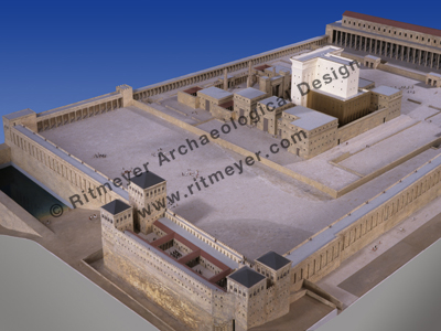
In this video, Jim Scudder of InGrace ministry interviews me on the spiritual significance of the Temple Mount in Jerusalem, its history and future.
One correction, the quote about the Middle Gate is in Jeremiah 39:3.
…for the latest research, analysis and products on Biblical Archaeology
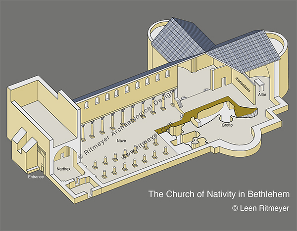
Is the grotto in the Church of the Nativity in Bethlehem the place where Jesus was born?
I believe that Scripture and archaeology show that the place in Bethlehem where Jesus was born was not a random cave or grotto, but a different location that was prepared centuries earlier for this purpose.
According to Luke 2.1-5, Bethlehem is the place where Joseph went for the Roman census. Both Joseph and Mary were descendants of the family of King David. When the Roman Governor Quirinius ordered a census to be carried out, Mary and Joseph had to travel to their ancestral home in Bethlehem. It must have been an uncomfortable journey when Mary was almost 9 months pregnant and had to travel, probably on the back of a donkey, from Nazareth to Bethlehem – a 100-mile-long journey through the Jordan Valley!
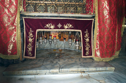
On arriving in Bethlehem, Joseph couldn’t find a place to stay. We are told that there was “no room in the inn”. The only available place for the Son of God to be born was a stable, which had to be shared with animals. How do we know that it was a stable? In Luke 2:12, an angel told the shepherds that a Savior was born and that they would find him as a babe lying in a manger. Mangers are feeding troughs for animals, usually found in stables.
Why was there was no room in the inn? The NT Greek word for “inn” is kataluma, which has been translated “guest room” in Mark 14:14 and Luke 22:11. In the story of the Good Samaritan in Luke 10:34, the Greek word for ‘inn’ is pandokion. This was a proper inn or caravanserai as it had an innkeeper which is called a pandokus. There is no mention of an innkeeper in the ancestral home of Mary and Joseph. Inns were large buildings, often with two stories of rooms built around a courtyard. The upper rooms were used by the travelers, while the animals would be kept in stalls or stables.
Large dwellings, such as the ancestral home of Mary and Joseph would have looked similar, i.e. two story high rooms built round a courtyard. As members of Joseph and Mary’s extended family had apparently arrived earlier and occupied the guest rooms, Joseph and Mary had to stay in the stable block of the same ancestral home.
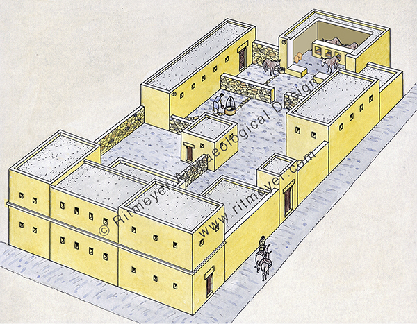
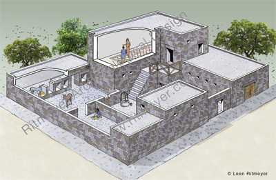
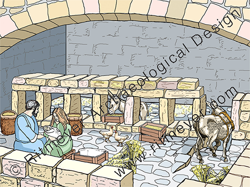
So, what did a stable look like in the time of Christ? From archaeology we know that stables looked like rooms with a fenestrated wall, i.e. an interior wall with several low windows. Animals were placed behind this wall, and sacks of provender were stored in the first half of the room. At feeding time, the fodder was put in wooden boxes or baskets and placed in these windows.
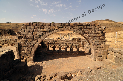
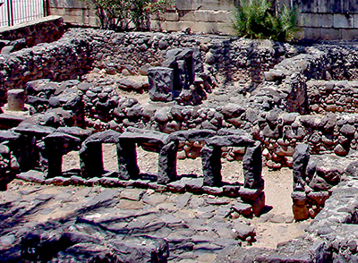
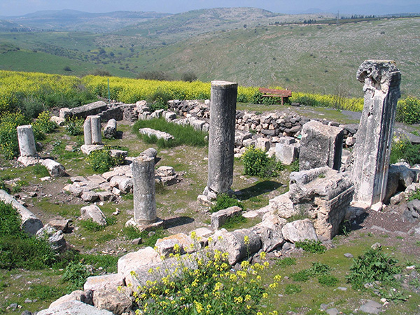
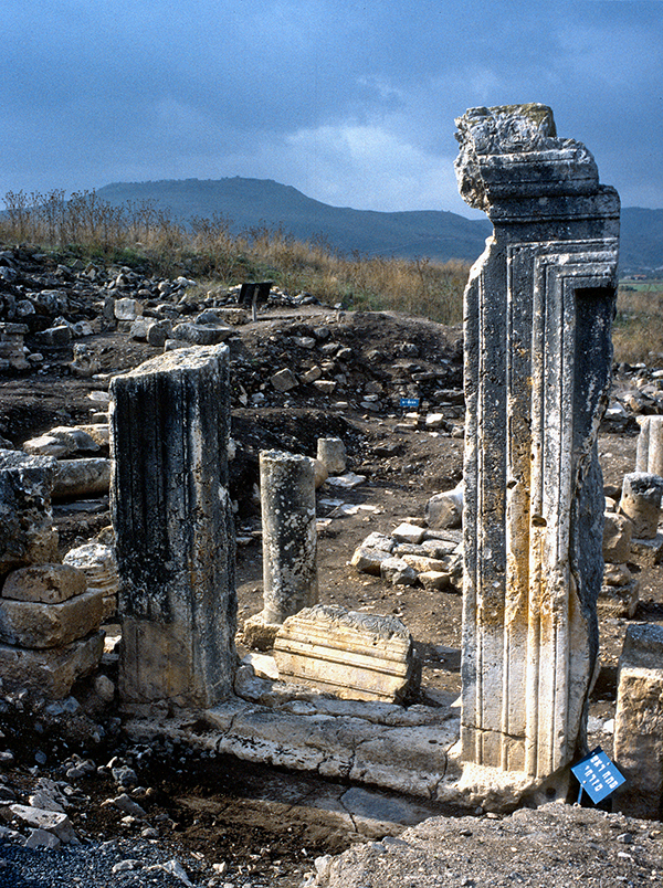
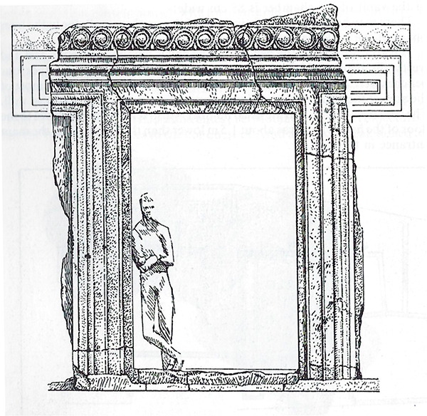
It was probably in the storage part of the stable block that Mary and Joseph had to stay and where Jesus was born and the babe was placed in a wooden box. Stables with fenestrated walls have been found in many places, such as Capernaum and Chorazin that are illustrated here, and in later monasteries.
So, where did the tradition that Jesus was born in a cave originate from? Here is a suggestion. After 135 AD, a Roman garrison occupied Bethlehem as indicated by Roman inscriptions that were found near Rachel’s Tomb. In the first and second centuries AD, the Romans venerated Asclepius as the most important god of healing. Many temples and shrines were built to celebrate his healing powers. The Roman soldiers may have built a shrine to Asclepius in a cave near Bethlehem. “It is possible that such a military presence would have led to the establishment of an Adonis cult in the same way as the Roman military presence in Aelia [Capitolina] led to an Asclepius/Serapis cult in the caves adjacent to the Pool of Bethesda.” [1]
In the fouth century, Constantine the Great tried to eradicate paganism and replace it with Christianity. The building of the Church of the Nativity over this cave may have been part of this program. Similarly, a church was built over the Pools of Bethesda.
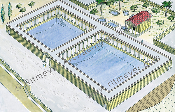
In a previous post I asked the question what is the importance of Bethlehem and which inn/hostel was chosen by God as the place for His son to be born in?
To prepare for the conquest of Jericho, Joshua sent out two spies that stayed overnight with Rahab. She was a harlot (zonah), yet living with her family, which is unusual. In Hebrew, the word zonah is closely related to mazon which means food, and lehazin which is to feed. It has been suggested that she ran an inn, where the two spies would naturally have gone for shelter. She also may have provided “extra services” as part of running the hostel. It possibly was a Canaanite custom, which was well accepted among those nations, who didn’t have the rule of God to guide their society. Because of her faith, Rahab was the only person, with her family, that was saved.
Rahab married Salmon and their son was called Boaz, who must have settled in Bethlehem when Judah captured its inheritance. Boaz married Ruth in Bethlehem and she became the great-grandmother of David (Ruth 4.10). Gentile Ruth was, of course, one of these amazing few women mentioned in the genealogy of Jesus in Matthew 1:5. King David was born in Bethlehem and anointed king there by Samuel the Prophet.
Near the end of his life, David had to flee from his son Absalom, when he rebelled against him. He stayed with the aged Barzilai the Gileadite, whose son Chimham returned with David to Jerusalem (2 Sam. 19.37-40). To provide him with a source of income, it appears that David may have given him part of his own inheritance in Bethlehem to build an inn (mentioned in the early Jewish source, Targum Yerushalmi, Jer. 41.17a), and called “Geruth Chimham”, “Habitation of Chimham” (Jer. 41.17). The building of inns/hostels may have been a family tradition! As small towns like Bethlehem usually had only one inn, it is reasonable to suggest that Jesus may have been born in this inn. As the guest chambers were full, Jesus would have been born in the stable block that was part of the same inn. It would be amazing to contemplate that through the generosity of David to Barzilai and his son Chimham, a birthplace for Jesus was prepared about 1000 years before his birth!
[1] Henri Cazelles (1992), “Bethlehem”, in The Anchor Yale Bible Dictionary, Vol 1, 712-714.
What was so beautiful about it?
The New Testament (Acts 3.2,10) records a notable miracle that was performed at the Beautiful Gate of the Temple. This was the gate where a man who had been lame from birth was begging. When Peter and John saw him, they told him that they did not possess any gold or silver or worldly riches. Instead, they healed him in the name of Jesus Christ of Nazareth. He then “went with them into the temple courts, walking and jumping, and praising God” (Acts 3.8). What a joyful occasion that must have been and one that was witnessed by many people. Jesus had healed blind and lame people before (Matthew 21.14), but now his disciples could perform similar miracles.
The time at which the miracle was performed was very significant. It was the ninth hour – the hour of prayer during which the evening sacrifice was offered in the Temple (Exodus 29.41).
David had composed a special psalm for this hour (Psalm 141.2). Jesus died on the cross at that very same hour (Matthew 27:46). Elijah’s sacrifice was also offered at the time of the evening sacrifice (1 Kings 18.29). At this time also, the angel Gabriel was sent to Daniel to answer his prayer (Daniel 9.21). The angel that came to Cornelius came at this time (Acts 10.3). God answers faithful prayers, but there appears to be a special time at which certain prayers are answered.
The miracle took place at the Beautiful Gate, but the question is, which gate is the Scripture referring to and how can it be identified? There were at least seven gates in the outer walls of Herod’s Temple Mount, but only in one of these gates have decorations been found.
In a previous post we wrote that some scholars have proposed that the Nicanor Gate or the Shushan Gate were the best candidates for the Beautiful Gate. However, we have argued that neither of these gates would have been suitable places for a lame man to beg.
A more likely location would have been the Double Gate in the Southern Wall of the Temple Mount, which I have described in my book The Quest, Revealing the Temple Mount in Jerusalem, 67-74.
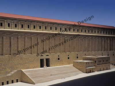
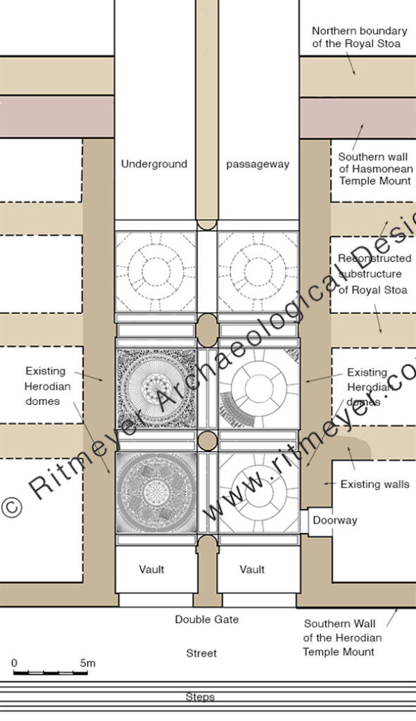
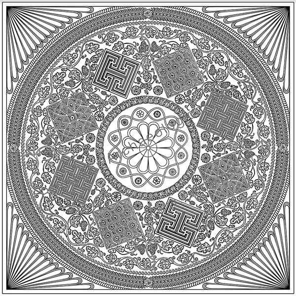
The ceiling inside the double passageway has beautifully carved domes, which have survived up to today. In 1973, I received permission from the Muslim authorities to survey these domes. At the time, scaffolding was erected beneath the southwest dome, so that we could touch and measure it. That was an unforgettable experience. The domes were photographed under my direction, and I planned and set up the drawings, which were completed in pencil by Nili Cohen and in ink by my late sister Martha.
Most of the worshipers went up to the Temple Courts through this gate, which was certainly worthy of the appellation “beautiful”. It also allowed for effective begging practices, as suggested on p. 74 of the above-mentioned book. According to Mishnah Middot 2.2, “whosoever it was that entered the Temple Mount came in on the right and went round and came out on the left, save any whom aught befell, for he went round to the left.”
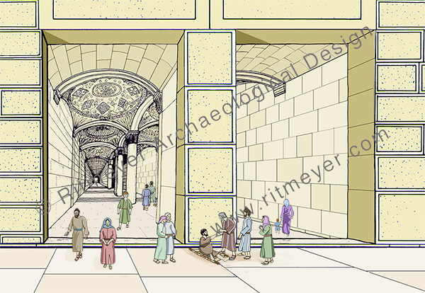
Two of the west domes are beautifully decorated with carved floral and geometric designs interwoven in intricate patterns.
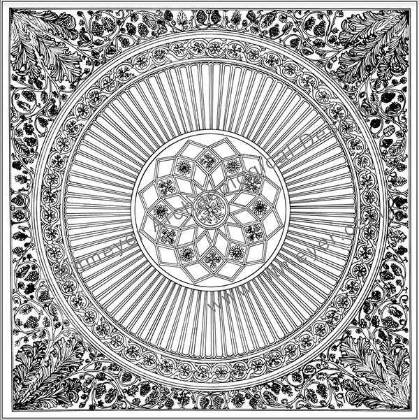
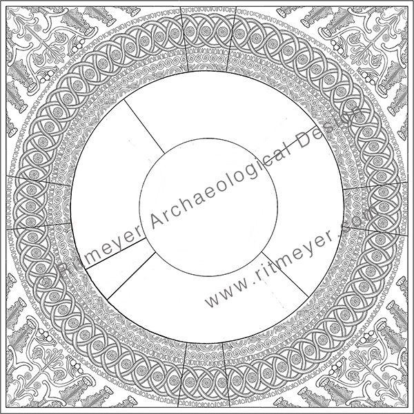
We had suggested (The Quest, p.74) that these two eastern domes may have fallen during the original construction or because of an earthquake. They were rebuilt during the same Herodian period but were left undecorated.
Nevertheless, it was indeed a gate with beautifully decorated domes that have survived the Roman destruction and are still there until this day. We suggest then that Peter and John healed the lame man at the Double Gate and from there he went “walking and jumping” to the Temple as far as Solomon’s Porch.
In our previous post we reported on the Arbel Fortresses and mentioned that we would describe the Arbel Synagogue in the next post.
Communal worship began in the Tabernacle and continued in the subsequent temples of Jerusalem. Synagogues emerged much later in time. Worship in synagogues was very different from that in the Temple. In the latter, cultic practice was led by a small group of priests and other officials, with the ordinary worshipers relegated to outer courtyards. In synagogues, leadership was open to all. Prayer and study replaced sacrifice, and ceremonies could be observed by everybody.
The first synagogues that were built in the Land in the 1st century, e.g. Gamla, Capernaum and Magdala, were flat-roofed and had benches built around the colonnaded interior. Later Byzantine synagogues had pitched, tiled roofs and were more elaborately decorated.
Synagogues were religious, cultural, and social centres of the Jewish community. Communal prayers and the study of the Hebrew scriptures were conducted for young students and adults, often in rooms set aside for that purpose. Whereas the main part of the synagogue, the assembly room, functioned as a meeting place with the emphasis on the Shabbat service, sacred meals were also served there, and communal law courts sat there.
The most important part of the Shabbat service was the reading of the Torah and its exposition, as noted by the author of Acts 15:21:
“For from ancient generations Moses has had in every city those who proclaim him, for he is read every Sabbath in the synagogues.”
In the fourth century, a Byzantine style synagogue was built in the centre of the settlement of Arbel, on the west side of the middle residential terrace. In 1987-’88, Zvi Ilan and Avraham Izdarechet began preservation and restoration work on the synagogue and its surroundings, and they asked me to prepare a reconstruction drawing.
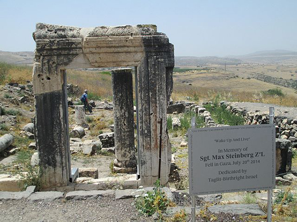
Its plan recalls other Byzantine synagogues in Galilee such as Capernaum, Chorazin, Tiberias, Meroth and others. Originally, the main entrance was in the eastern wall and was partially constructed from one gigantic rock.
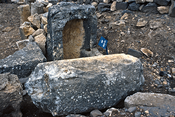
In the north wall of the synagogue, an installation that resembles a charity chest or community treasury has been found.
The synagogue had the shape of a basilica and was oriented north-south and measured 20 by 18.5 meters. In contrast to the village houses that were built of dark basalt, the synagogue was constructed of limestone blocks. The interior had three rows of pillars with heart-shaped pillars in the corners and four steplike benches were built along three of the walls.
A round niche for the Torah ark was later constructed in the southern wall, with a stone platform (bema) in front of it for the reading of the Torah. Such a feature was characteristic of later synagogues. There was also an additional entrance made in the middle of the north wall at this time. This new axis from north to south was designed to direct worshipers to face towards Jerusalem when they entered the synagogue through the northern entrance.
The three rows of columns on the first floor had Corinthian capitals, while those of the second story were topped by Ionic capitals. Smaller Ionic pilasters, flanking double windows, adorned the walls of the upper story.

A large, paved courtyard was made in front of the main entrance. It may have served as what is called in rabbinic literature a “door within a door”, that is a kind of entrance room or place of assembly. The building was topped by a tiled roof.
The Arbel Synagogue continued to function until the earthquake of 747 AD, when it was severely damaged, and the settlement destroyed.
A case of mistaken identity
Judith Sudilovsky reported in the Jerusalem Post on the opening of the Arbel Fortress following 1.5 years of conservation work.
“Towering majestically over Lake Kinneret, looking out over a breathtaking view of the upper and lower Galilee including Mt. Nitai, and further towards the Golan Heights and Mt. Hermon, the stark cliff of Mt. Arbel has been witness to plenty of history.”
The cliff hanging Arbel Fortress in question is known as Qala’at Ma’an. It was built in the beginning of the 17th century AD by Fahr al-Din II, of the Druze Ma’an dynasty, governor of Lebanon and Galilee.
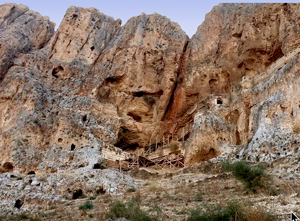
“The fortress was not allowed to stand for too long, and within a decade of its construction Ottoman forces destroyed it for reasons unknown. Time and nature did their share, and over the centuries the three-story fortress—a popular site for intrepid hikers to visit–fell into great disrepair making it dangerous for visitors.”
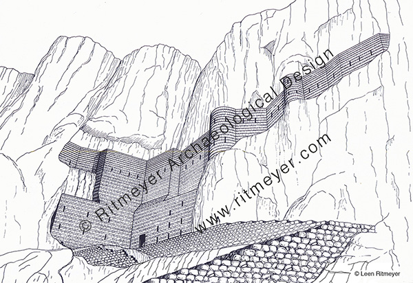
Despite its short existence and subsequent neglect by both nature and pillage by men, the Arbel Fortress still has an imposing presence hanging halfway down the cliff. We are grateful for this conservation project that makes the site more accessible for visitors who can also enjoy the spectacular views of the surroundings.
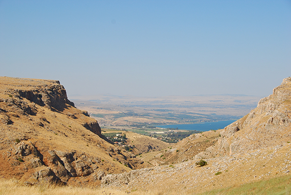
Arbel is a site of uncommon natural beauty with steep cliffs plunging down toward the Sea of Galilee, overlooking Wadi Hammam, Magdala, the place where Mary Magdalene lived, and Capernaum.

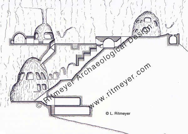
For a long time, it was thought that Fahr al-Din’s citadel was the fortress of the Jewish rebels who fought against Herod. The late Zvi Ilan conducted a systematic survey of these caves in 1987- ‘88, in which I participated. The actual caves were located on a trail on which, for decades, hikers walked to the Ottoman fortress. Initially, Zvi had no idea that the real caves were hidden only a few meters away! During the Hasmonean period, about one hundred caves were hewn in the cliff for residential purposes and protected by walls. Some caves contained two or three rooms. The survey showed that the outer wall of the fortress of Fahr al-Din was built in front of some of those Hasmonean caves. This caves consisted of rooms, cisterns, stairways and even a mikveh that was found on the third floor.
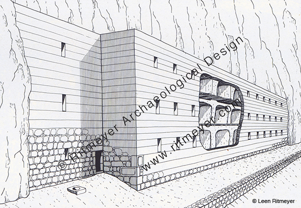
To his great surprise, Zvi Ilan discovered another cave fortress to the east of the Ottoman fortress that was 75 meters long, 14 meters wide and 10 to 12 meters high. A long wall was built in front of it, to the top of the hewn rock. An interior wooden walkway was constructed between the caves and the wall. The date of this fortress could not be established without a future excavation. However, according to Zvi, the possibility that this fortress was built as part of the preparations for self-defence at the site at the end of the Second Temple period, should not be ruled out.
As mentioned in Judith’s article, Arbel has seen plenty of history even though it is so little known. What is known about its history?
The ancient settlement and lookout post of Arbel may have been the one that is mentioned in the Bible as Beth-Arbel. This fortress was destroyed by Shalmaneser V in 722 BC, when he was on his way to capture Samaria: “all your fortresses will be devastated – as Shalman[eser] devastated Beth Arbel on the day of battle, when mothers were dashed to the ground with their children.” (Hosea 10:14). The defeat of this settlement must have been particularly brutal and an example to Israel of the cruelty of the Assyrian invaders.
The fertile land on the Valley of Arbel that is watered by the abundant water that flowed through it, enabled the inhabitants of Arbel to grow grain, olives and grapes, and flax that was used in the production of linen. This supported a strong economic base for Arbel that was built on terraces in the rocky slope on the northern periphery of the Arbel Valley.

Two great legal minds of the mid-second century BC, the sage Nitai the Arbelite, who was born here, and Joshua ben Perahiah taught Torah using a Deuteronomy scroll that these two sages had received from Simon the Just, who was then High Priest in Jerusalem (Mishnah Avot 1:6). Nitai was also vice-president of the Sanhedrin. This indicates the high level of development of Arbel as a spiritual centre for Galilee.
The ancient settlement was almost entirely surrounded by cemeteries. Later traditions mention Arbel as the burial place of Nitai of Arbela; Dinah the daughter of Jacob, and several of her brothers; and that of Seth the son of Adam, and the exilarch Hezekiah, a leader of the Jewish community from the time of the Babylonian exile.
Arbel is now also known for its unique system of the above-mentioned fortified caves where Hasmonean loyalists fighting the Galilean Zealots hid. In 161 BC, a deadly battle took place at Adasa between the Maccabean forces led by Judas and the Seleucid forces that were commanded by Nicanor. The Seleucids were defeated and Nicanor was killed. In order to revenge his death, Demetrius the Seleucid king sent his general Bacchides the following year to the land of Judea. “They took the road to Galilee and besieged the Mesalot (fortified caves) in Arbel and captured it and put many people to death” (1 Mac. 9:2).
In 38 BC, Herod tried to conquer the land with Roman support and battled the supporters of Antigonus II, the last Hasmonean king of Judea, who were hiding out in these caves. Herod’s men fought for forty days to no avail. Herod then devised a plan whereby soldiers would be lowered from above in crates connected to iron chains. After a bloody battle, Herod’s forces eventually routed the Jewish rebels.

In 66 AD, at the beginning of the First Jewish-Roman war, Josephus fortified the caves with walls and used them as storage base at the beginning of the First Jewish-Roman war.
After the Roman destruction of Jerusalem in 70 AD and the Bar-Kochba rebellion that lasted from 132-136 AD, many Jerusalem Temple priests fled to villages in Galilee. It was then that the association of Arbel with the concept of Messianic redemption became widespread. One poet from Tiberias claimed to have seen an appearance of the Messiah in the plain of Arbel on the eve of Passover.
In the fourth century, a synagogue was built in Arbel (see image above), which we will report on in the next post.
Thanks to the conservation work, both these fortresses and the caves can be safely visited again, a wonderful opportunity for hikers and people that love the land. These caves are also located on the Jesus Trail. This is a 40 mile (65 km) long hiking and pilgrimage route following the road that Jesus would have taken when he moved from Nazareth and went to live in Capernaum. It goes through the Wadi Hammam that is located between the Horns of Hattin of Crusader fame, or rather infamy. Hikers will surely enjoy seeing the renovated Ottoman fortress and the many caves that bring history to life.
A palace fit for a High Priest
My friend and colleague Hillel Geva, director of the Israel Exploration Society and editor cum publisher of the Jewish Quarter Excavations in the Old City of Jerusalem Conducted by Nahman Avigad, 1969-1982, sent me a copy of Volume VIII of this important series. Hillel is to be congratulated on the preparation and publication of this beautiful volume which sets a high standard of how excavations should be studied and published.

This Volume VIII describes the excavation of the archaeological remains of the Palatial Mansion, which, as suggested by Avigad, may have been the Palace of the High Priest[1]. This mansion may have been built by Annas who was High Priest from 6-15 AD, as he was one of the few people who could have afforded to build such a large and lavishly decorated residence. The family of Annas was very wealthy as they controlled the Temple Market that was set up in the Temple Courts and out of bounds for normal moneychangers. Josephus called one of the sons of Annas “a great hoarder of money”.
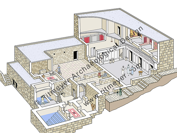
This building covers 600 square meters and is one of the largest residences dating from the Second Temple period ever uncovered, not only in Jerusalem, but in the whole of the country. This mansion is located on the eastern edge of the southwestern hill which slopes down to the Tyropoeon Valley. Overlooking the Temple Mount, it would have been considered prime real estate in the 1st century AD, as indeed it is today.
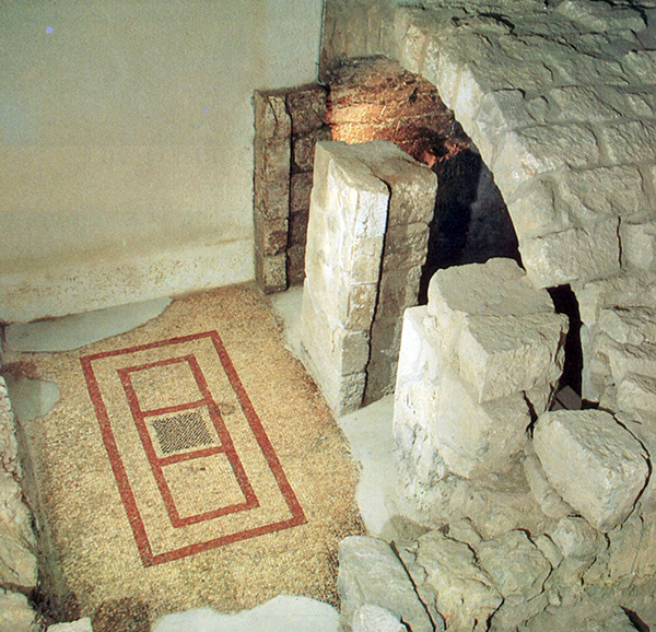
In the first chapter of this magnificent volume, Hillel describes the stratigraphy and architecture of the Palatial Mansion in great detail. The structure is built on two levels, each consisting of two stories and has many rooms built around a central open courtyard. The walls of several of these rooms were decorated with fresco and stucco designs. Seven rooms had mosaic floors, three of which were decorated with colorful carpets.
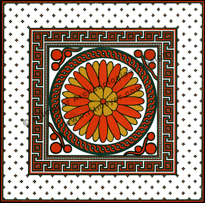
Eight mikva’ot (ritual baths), catering for the purification requirements of the residents, were found in the mansion indicating that the complex was occupied by priests who served in the Temple.
After making the publication drawings and studying the architectural remains, I made this new reconstruction drawing to give an overall idea of what the mansion may have looked like:
In this volume, every wall and locus is recorded and accompanied by photographs, plans and sections. Of necessity, this takes up the bulk of the book. Different authors have written short chapters on the fresco and stucco decoration, mosaic floors, and ritual baths.
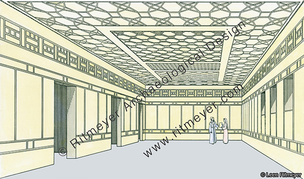
The building was destroyed by the Romans in 70 AD, while it was in the middle of undergoing extensive renovations with fresco wall decorations being covered over with white stucco. This consisted of broad panels in between two bands of imitation masonry, modelled on “headers and stretchers.” However, on the basis of the stucco remains of the northern wall of the Reception Room that extended to the greatest height, it was clear that there was an additional band of decoration just below the ceiling. This different style of imitation stone work could only be reconstructed on the basis of a complete panel which was found in the debris on the floor below this wall – see reconstruction drawing below.
The floor was also found littered with small fragments of decorated stucco with different patterns, which had fallen from the ceiling. Before restoration work on the Palatial Mansion began, Avigad presented me three large trays of a representative sample of ceiling fragments and asked me to try and make some sense of them.
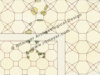
All the pieces showed geometrical patterns in relief. It was clear that the original design must have been divided into two parts, as some fragments had an “egg-and-dart” motif and the remainder were plain. Measuring the angles in the first group – squares, octagons and triangles of 45 degrees could be discerned. The second group consisted of squares, hexagons and triangles of 30 degrees. After trying out various possibilities and taking into consideration the dimensions of the room, the number of fragments found and their representative proportions, I hit upon this ceiling design which was later partially incorporated in the restoration.
I was not part of the original team, as I was then working as architect on the Temple Mount Excavations. However, since 1978, I have spent many years working on the publication plans of all the excavation areas of the Jewish Quarter Excavations. Each of the publication plans, elevations and sections of this magnificent residence including reconstruction drawings, were prepared by me on completion of the excavation.
It should be noted that this volume, like the previous ones, is a scientific publication and of interest to archaeologists, historians and the interested lay person. Other readers may be more interested in a popular book, such as that published by Avigad, who summarised the excavation of this extraordinary mansion in his book Discovering Jerusalem[2]. This Vol VIII is the complete excavation report, published some 30 years after the first spade went into the ground.
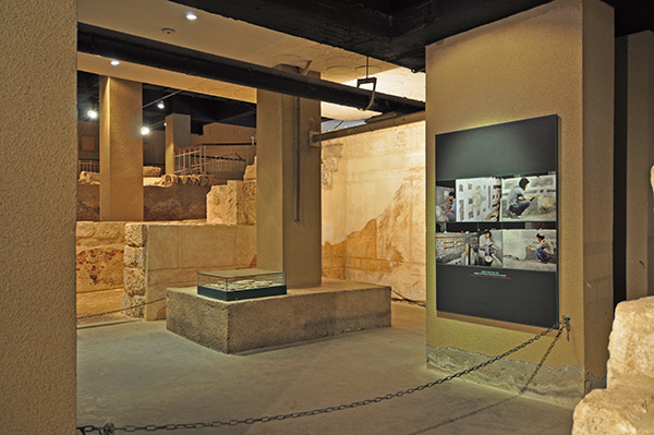
When the excavations were finished, a four-story high modern building, the Yeshivat Hakotel (a Jewish school for the study of the Torah and the Talmud) was built over the preserved remains. The mosaic floors were removed and, after conservation, exhibited in the Israel Museum. On completion of the building of the yeshiva, an archaeological museum, named the Herodian Quarter, or Wohl Archaeological Museum, was planned in what had become the basement of the new building. Avigad planned and directed the work for two years, from 1985-87, putting me in charge of its execution. He visited the site twice a week for a couple of hours, leaving me in charge for the rest of the time.
Although in this Volume VIII, only just over two pages are dedicated to this restoration work, it required a lot of thought as to how best to preserve the remains and how to decide where to add stones. Some of the the walls were made higher to help the visitor with spatial orientation. The restoration of the Reception Room demanded special attention as we tried to give an impression of what the beautiful stucco decoration of both the walls and ceiling would originally have looked like. This restoration work was published in book form by Avigad[3]. I treasure my copy of this book which he gave me, inscribed with the dedication “a souvenir from a joint work”.
This volume is a worthy addition to the previous seven volumes of the Jewish Quarter Excavations which cover the excavations of the Broad Wall, the Israelite Tower (later identified as the Middle Gate of Jer. 39:3) and other fortifications, the Byzantine Cardo and the Nea Church, and other buildings of the Second Temple period.
Avigad passed away in 1992 and therefore was unable to publish the final reports of these important excavations directed by him. We are grateful that Hillel Geva, who served as archaeologist since the beginning of the dig, has taken upon himself to publish the results in such magnificent volumes. The next volume will describe the many small finds that were discovered in the Palatial Mansion.
[1] Avigad (1989), 76.
[2] Avigad, N. (1980, [Hebrew]; 1983 [English]). Discovering Jerusalem (Jerusalem, Nashville).
[3] Avigad, N. (1989), The Herodian Quarter in Jerusalem, Wohl Archaeological Museum (Jerusalem).
from the domus ecclesia to memorial church
During the reign of Constantine the Great (306-337) and especially after his conversion in 312, Christianity spread rapidly in the Byzantine Empire and even more so in the Holy Land. After the visit in 326 AD by Queen Helena, Constantine’s mother, many Gentile pilgrims came to visit the Holy Land. Some remained and chose to live lives of seclusion in remote areas such as Sinai, around the Sea of Galilee, in the Judean Desert, and in Samaria, while others lived in towns and cities.
In the wake of this influx of pilgrims from the Byzantine Empire, the prominence of the domus ecclesia diminished and larger buildings became necessary to accommodate the many worshipers. Church buildings came into the ascendency, and their construction became the primary architectural focus during the later Byzantine period. Two kinds of churches developed: the basilica with its long hall, and the centrally designed (circular, octagonal, or hexagonal) memorial church. Basilicas were mainly used for communal worship, while the centrally designed churches commemorated special Biblical places or events.
During this time, the Gentile Christian population of Capernaum had increased dramatically and outnumbered the Jewish Christian members of the congregation. Radical changes were made to create a new Byzantine-style church inside the fourth century enclosure wall.
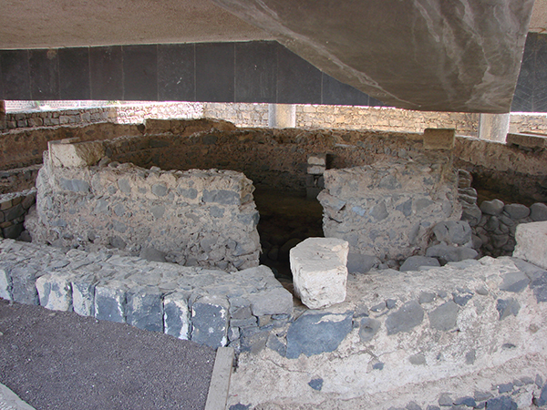
Substantial remains of the foundations of an octagonal church, that dated to the fifth century and was built with limestone blocks, were excavated in Capernaum. This limestone that came from the Arbel region could be carved easily and polished to a high degree. In the first half of the fifth century, the buildings that stood inside the enclosure were demolished and covered over. Instead of the domus ecclesia with its explosion of colour of the fourth century, a new and monumental was built in its place.
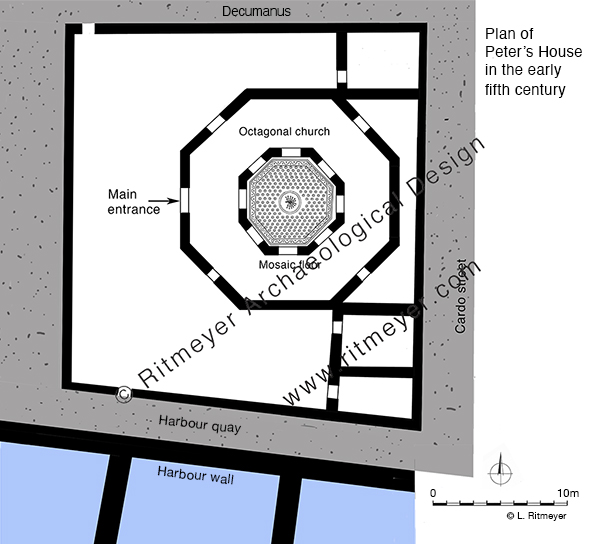
The walls of the inner octagon, which measured 7.9 m (26 feet) across, were built on the basalt foundations of the domus ecclesia and then another octagon, measuring 16.53 m (54.2 feet) across was added around it to complete the first phase of the new church. The church was paved with mosaics. The centre of the inner mosaic has a medallion with a peacock design, apparently symbolising immortality to the early Christians. Annexes were built to the west of the church and in the northeast and southeast corners of the square enclosure.
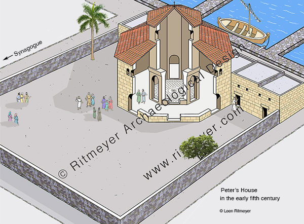
Sometime in the second half of the fifth century, a partial octagonal porch was added on the north, west and south, and an apse containing a baptistry on the east. This apse was constructed on the other side of the east wall of the enclosure.
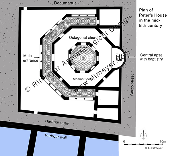
The baptistry had steps leading down to it, indicating that adult baptism by immersion was practised in the fifth century.
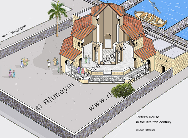
After the Islamic invasion of 638 AD, Capernaum was abandoned and the church and synagogue, that had existed side by side, fell into ruin. After the earthquake that hit Galilee in 749 AD, Arab inhabitants began to systematically rob the buildings of their stones, leaving precious little for future archaeologists to investigate.
In 1866, Captain Charles Wilson exposed some foundations of the synagogue, with the unfortunate consequence that local people began to dig deep into the ground near the synagogue and near the church to find more limestone blocks which they either sold as building material or burned into lime. Other contractors used the exposed ruins as a quarry.

To stop this looting the Franciscan Custody of the Holy Land acquired the site in 1894 and exploratory excavations were conducted in 1905 by Heinrich Kohl and Carl Watzinger. Other excavations were conduction under leadership of F. V. Hinterkeuser and these continued until the outbreak of World war I, After the war, excavations were resumed by Gaudenzio Orfali until 1921. Orfali initiated the restoration of the Byzantine synagogue in 1922-1925.
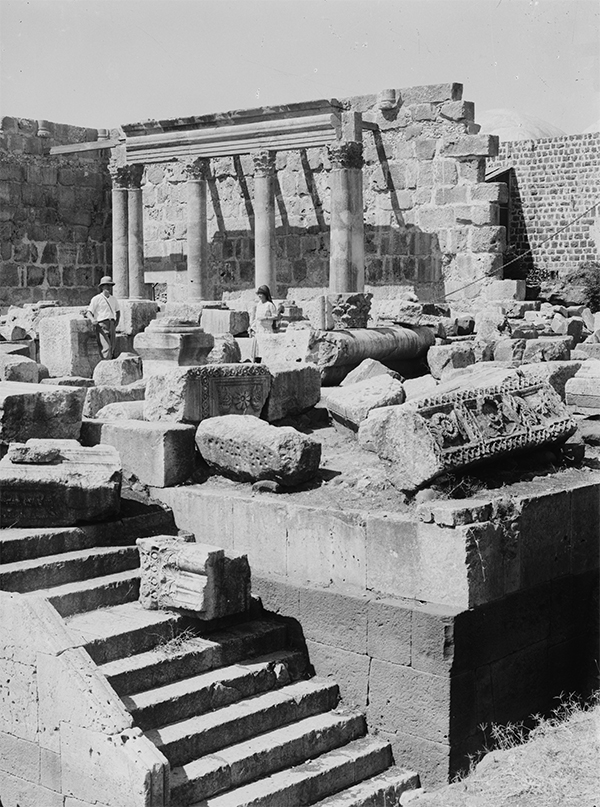
In 1968, Virgilio Corbo and Stanislao Loffreda continued excavating Capernaum and conducted eighteen campaigns until 1985, and the restoration of the synagogue was continued by Corbo since 1969. It would have been great if similar efforts would have been put in the restoration of the Byzantine church, but unfortunately that won’t happen unless that new and incongruous UFO-like modern church that was built over Peter’s House (designed by the Italian architect Ildo Avetta and dedicated in 1990) would start its engines and fly off!
Nevertheless, it is thanks to the labours of the Franciscan Custody of the Holy Land that tourists and pilgrims can visit Capernaum again and see the place that was made famous when Jesus chose it as his hometown.
the domus ecclesia from the first to the fourth century
In our previous post we wrote that the House of Peter eventually developed into a church. It was a slow process that took four centuries. The first stage began in the second half, or perhaps even at the end of the first half of the first century, when the east courtyard transformed into a large room. While before the sky was its ceiling, this large space, measuring 5.80 by 6.45 m (21 by 19 feet) was now roofed over. A central wooden beam placed on top of the walls divided the ceiling into two parts so that shorter beams could be used to span the large room.

Several layers of plaster were found on the walls and the floor. Quite unusually, this is the only room in Capernaum that was plastered at this time, pointing to the use for non-domestic purposes. There was also a change in pottery. Beneath the plastered floor, the usual repertoire of domestic vessels, such as cooking pots, bowls and juglets, was found. Above the plastered floor, however, only storage jars and oil lamps were discovered.
Who worshiped in this sacred space? After Pentecost, the early Christian believers “devoted themselves to the apostles’ teaching and the fellowship, to the breaking of bread and the prayers” (Acts 2:42), and according to Acts 2:46, this was done “in their homes”, or “from house to house”. The archaeological evidence points to the use of this plastered room in Capernaum as a large house-church or domus ecclesia. This space is sometimes referred to as the ‘venerated room’.
Until the 4th century, the population of Capernaum was entirely Jewish, and the Synagogue of Capernaum continued to operate as normal. The people that worshiped in the domus ecclesia were Jewish converts to Christianity, called minim by the rabbis:
“In passages referring to the Christian period, minim usually indicates the Judæo-Christians, the Gnostics, and the Nazarenes, who often conversed with the Rabbis on the unity of God, creation, resurrection, and similar subjects (comp. Sanh. 39b). In some passages, indeed, it is used even for “Christian”; but it is possible that in such cases it is a substitution for the word “Noẓeri,” which was the usual term for “Christian.”
In the late fourth century, at the initiative of Count Joseph of Tiberias, who was a friend of Constantine the Great, major changes took place in the development of Peter’s House. An approx. 120m long enclosure wall was built around Peter’s House, turning it into an almost square sacred compound, or insula sacra. Some of the first century rooms were destroyed to create more space around the domus ecclesia, giving the whole complex a stronger religious character.

There were two entrances in this enclosure wall, one in the north and one in the south. Interestingly, no entrance was made in the east wall to the Cardo street, the main north-south road on which the synagogue was located. Instead, a new east-west street (decumanus) was constructed north of the complex. Is this an indication that the two communities, Jewish and converts to Christianity, tried to remain separate?
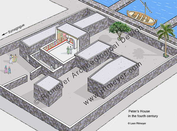
The domus ecclesia room was also changed. A central arch was built in the room to support a higher ceiling, and the walls of this room were decorated with fresco. Various colours, such as red, pink, yellow, brown, green and white were used to create rectangular panels with alternating geometric and floral designs.
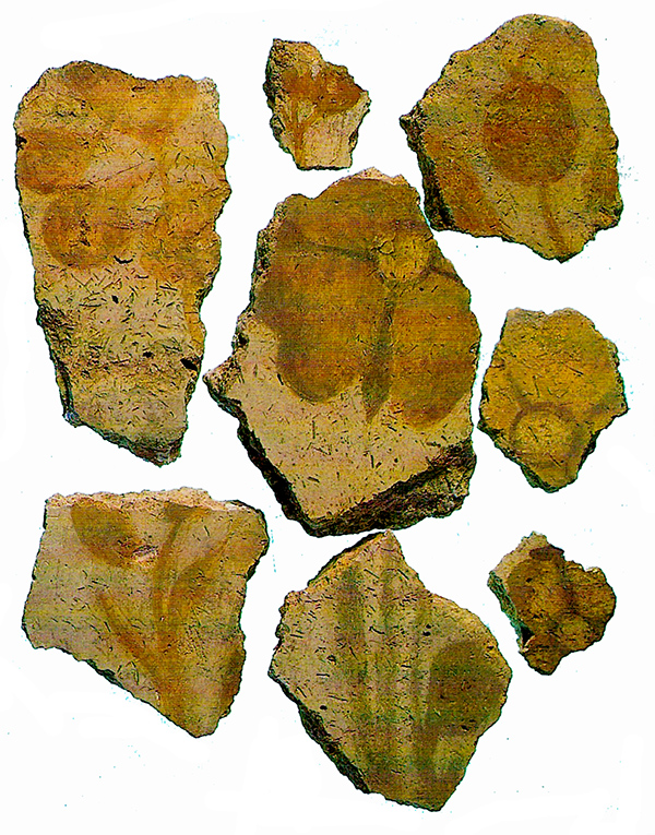
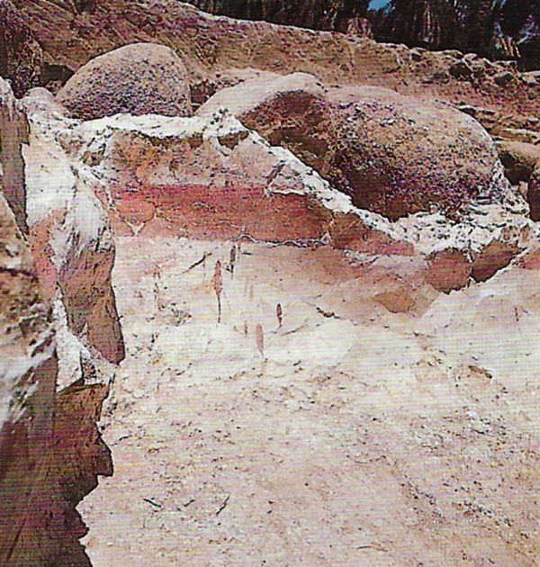
In line with Jewish practice, no human or animal forms were portrayed. Inscriptions, or rather graffiti, in Greek, Latin, Syriac and Aramaic were scratched in the walls by apparently Christian pilgrims. Some of these graffiti mention monograms of Jesus and of Christ. The name of Peter is one of the many inscriptions scratched on the walls.
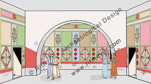
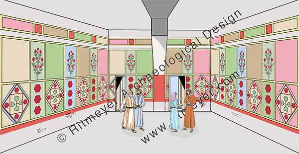
On the northern side of the domus ecclesia, a sacristy was built where were usually sacred vessels and vestments were kept. On the east side an atrium was added which served as an entrance hall to the main room. This shows that in the fourth century the Jewish Christian population had increased substantially but were still living side by side with the Jewish people of Capernaum. All this was going to change in the fifth century when there was a huge influx of Gentile Christians …
The town where Jesus chose to live
After Jerusalem, Capernaum is the site most visited by Christian pilgrims and tourists. Their main interest is to see the place where Jesus made his home after his words were rejected in his hometown of Nazareth (Luke 4:16-30).
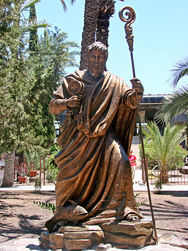
The fulfilment of the prophecy of Isaiah 9:2: “The people who walked in darkness have seen a great light; those who dwelt in a land of deep darkness, on them has light shone”, required that Jesus would move from Nazareth to Capernaum. In the days of Isaiah that great light was Hezekiah, the son of Ahaz, but this prophecy ultimately referred to the future Messiah. Matthew 4:13-17, confirms Isaiah’s prophecy as the main reason why Jesus made Capernaum his home: “And leaving Nazareth he went and lived in Capernaum by the sea, in the territory of Zebulun and Naphtali, so that what was spoken by the prophet Isaiah might be fulfilled: “The land of Zebulun and the land of Naphtali, the way of the sea, beyond the Jordan, Galilee of the Gentiles – the people dwelling in darkness have seen a great light, and for those dwelling in the region and shadow of death, on them a light has dawned.”
Capernaum is located in a basalt region and the darkness mentioned in this Scripture is perhaps reflected by the dark basalt stones of which all the buildings were made.
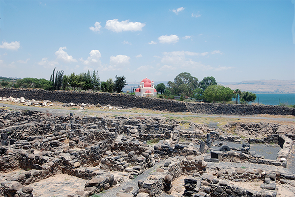
Jesus would, of course, have known beforehand that he couldn’t stay in Nazareth, for it was not located in Galilee of the Gentiles, nor on the Way of the Sea (aka the Via Maris). Bethsaida, for example, was by the sea, but not in the region of Zebulun and Naphtali, and Chorazin (or Chorazim) was not by the sea. Only Capernaum met Isaiah’s criteria. Capernaum wraps around the northwest shore of the Sea of Galilee and was located on Via Maris, the major trade route between Syria and Egypt. Jesus’ move from Nazareth to Capernaum was not a retreat into remoteness but a deliberate move into a more diverse region where his message and impact could have a wider and more receptive audience. It was nothing less than a move from the shadows to the spotlight. Capernaum was engaged with the world, via the International Highway and the Imperial Road.
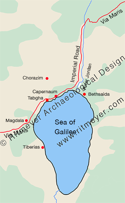
This major highway was used by many traders, who, apart from buying and selling, also exchanged items of news. By living on the Via Maris, Jesus could be assured that what he did and said would be carried far and wide to the larger audience for whom his message was intended. This explains how, according to Matthew 4:24, the fame of Jesus “spread throughout all Syria, and they brought him all the sick, those afflicted with various diseases and pains.” Jesus himself, as far as we know, never went to Syria, but the traders would have told the people they met all about him and the wonderful works he did.

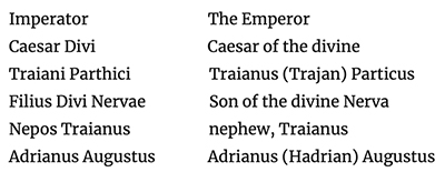
The inscription reads:
So, what do we know about Capernaum? Excavations by Franciscan archaeologists have revealed that Capernaum was established in the 2nd century BC and abandoned in the 11th century AD. We are going to examine what the major developments of Capernaum were and specially that of Peter’s House.
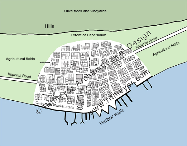
Capernaum was much larger than the excavated area and originally stretched for 300m along the shore and measures about 200m from north to south. The village was probably divided into 4 quarters by the main north-south running Cardo and east-west going Decumanus, with two sections of fishermen’s houses situated on either side of the southern part of the Cardo, close to the sea and harbour, while wealthier houses, such as the ones belonging to the centurion, the ruler of the synagogue and the tax collector, were probably located closer to the hills, away from the harbour and nearer the Decumanus.
The House of Peter where Jesus may have stayed was located west of the Cardo, in between the synagogue (see also here) and the harbour.
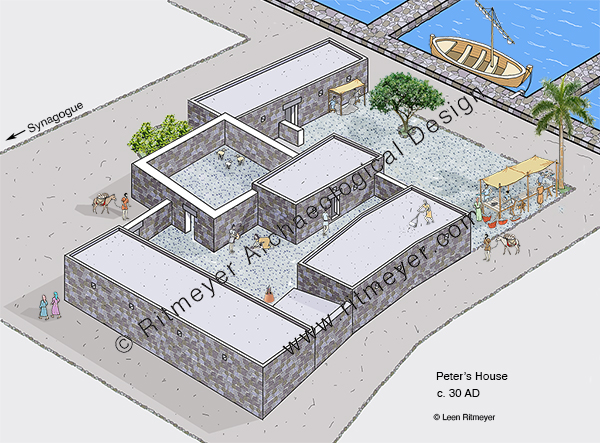
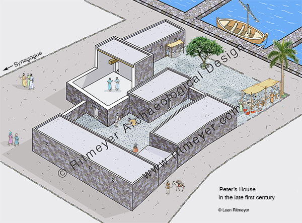
Peter’s House consisted of ten rooms built around three courtyards. Most of the domestic activities took place in the northern courtyard. Animals were kept in the courtyard to the east, and the southern courtyard, which was next to the harbour, was presumably used for fishing activities such as mending nets, selling fish and other activities. Later in the century, the east courtyard was used as a place for religious gatherings.
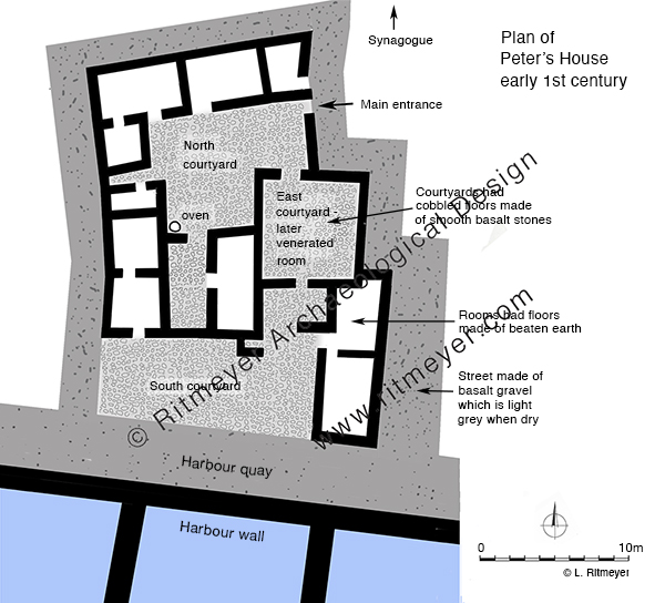

In this reconstruction drawing we imagine Peter’s boat moored alongside his house. In the courtyard we see two men under an awning mending their nets, and ask ourselves if Jesus perhaps did help Peter sometimes with the mending of the nets? Women are preparing food and baking it in an oven, and there was a stall where fish was sold. On the roof are two stands for the drying of fish.
Capernaum, Kfar Nachum in Hebrew, means the Village of Comfort. Jesus brought comfort to people that suffered from all sorts of diseases, to people that were politically and militarily oppressed by the Romans, to people that wanted to hear the Gospel of the Kingdom of God, but received no spiritual comfort from their Jewish leaders.
Making Capernaum his home, was also a comfort for Jesus. The son of man had not “where to lay his head.” He was often like David in the wilderness, finding rest wherever he could. The story of the healing of Peter’s mother-in-law, who after she was healed “rose and ministered to them” gives the idea that when he was in Capernaum, he probably stayed in one of the rooms in Peter’s house. It shows that Jesus loved being with his friends. We all need friends and so did Jesus.
Over the next few centuries, the House of Peter developed into a church building, which will be the subject of a subsequent post.
Did Jesus preach in this synagogue?
After Jesus moved to Capernaum, he made it a base for his preaching activities. The Gospels tell us that “Jesus went about all Galilee, teaching in their synagogues” (Matthew 4:23). He would go into the synagogues on sabbath days, as it was here that the people came together to worship. Although the Gospels don’t mention any particular synagogue where Jesus may have preached, archaeology has revealed the remains of a few Galilean synagogues that existed in the first century, namely in Capernaum, Magdala and Gamla. These synagogues were built of local basalt stones and this is reflected in our reconstruction drawings. A synagogue in Nazareth is mentioned in the Gospels, but no remains have been discovered so far. We have posted before on the Synagogue at Capernaum.
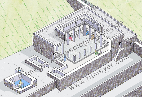
All three synagogues had a large meeting room with benches built around the walls. Some synagogues, such as that in Gamla, had a ritual bath, (called a mikveh in Hebrew), for ritual bathing nearby. This synagogue had a study hall attached to the building, as did the one discovered in Magdala.
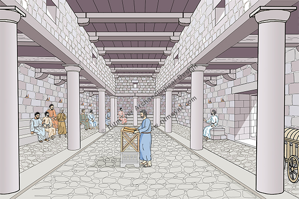
The Gospels tell us that the Law of Moses was read every sabbath in the synagogue: ” For Moses has had throughout many generations those who preach him in every city, being read in the synagogues every Sabbath” (Acts 15:21). The public preaching in the synagogue was usually done from a chair called “Moses’ Seat”, as mentioned in Matthew 23:2. When Jesus spoke in the synagogue of Nazareth, after having read from the prophet Isaiah, he rolled up the scroll, gave it back to the attendant, and sat down.” Two such “Moses’ Seats” have been excavated, one in Chorazin and the oher in Hammath-Tiberias. These two latter synagogues were from the later Byzantine period, but it is possible that similar seats were used in the first century too.
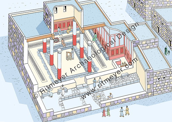
In 2009, a first century synagogue was uncovered in Magdala during a salvage dig in preparation for the building of a new hotel in the Franciscan Church compound. The synagogue features a large reading room and a smaller study room in front of it. The entrance was from the west. A large stone in the study room was found to have two grooves near the sides and may have been used to place a scroll for reading or copying.
The synagogue room has a raised corridor with a bench running along the wall. A central rosette with flanking meander patterns made of mosaic decorated the floor. The walls were decorated with fresco patterns in dark red panels inside a mustard-coloured frame. The roof was supported by six columns that had red coloured fresco still clinging to some of them. Near the centre of the room, a rectangular stone with four feet was discovered. This stone, that apparently served as a support for a reading platform or lectern, was decorated with a relief of a seven-branched menorah, flanked on either side by amphorae and columns. These decorations are reminiscent of the Jerusalem Temple.
Magdala is the city where Mary Magdalene came from. It was a large city and recently another synagogue was discovered there. It is not recorded that Jesus preached in a synagogue at Magdala. However, as he usually went to synagogues to preach, it is highly likely that he did and would have met many people there, including Pharisees. One of those Pharisees had invited Jesus to his home to have a meal with him (Luke 7:36). That is where Mary Magdalene approached Jesus and was healed by him. She became an ardent follower of Jesus, was present at the crucifixion and was the first woman to whom Jesus appeared to after his resurrection.