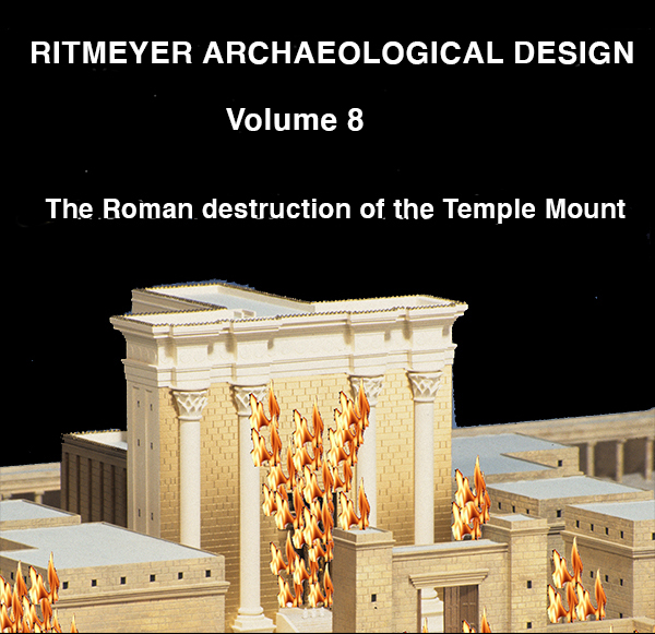
Josephus Flavius, also known as Yosef Ben Matityahu, was an eye-witness to the siege of Jerusalem. He somehow survived the siege of Yotvat in Galilee and with one of his soldiers surrendered to the Roman forces in July 67 CE. The Roman forces were led by Flavius Vespasian and his son Titus, both subsequently Roman emperors. Two years later, Josephus was released (cf. War IV.622-629) and according to his own account, he appears to have played a role as a negotiator with the defenders during the Siege of Jerusalem in 70 CE. The works of Josephus provide crucial information about this First Jewish-Roman War. Here, we would like specially to examine his account of the Roman destruction of the Temple Mount in Jerusalem.
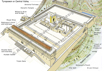
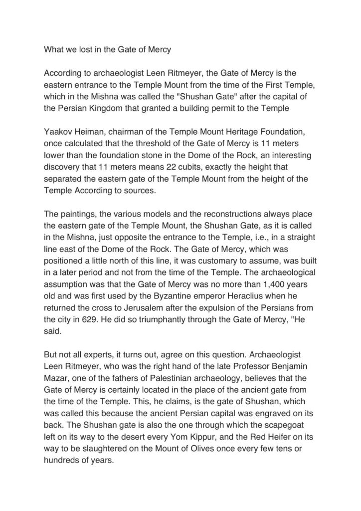
In 19 B.C.E. the master-builder, King Herod the Great, began the most ambitious building project of his life, the rebuilding of the Temple in lavish style. To facilitate this, he undertook a further expansion of the Hasmonean Temple Mount by extending it on three sides, to the north, west and south. The former extension required the filling in of a deep valley to the north of the pre-Herodian Temple Mount. The Shushan Gate remained the only gate in the Eastern Wall. Towers were erected at each corner and a large water reservoir was built at the northeast corner, the so-called Pool of Israel. At the northwest corner, the massive Antonia Fortress was built to protect the Temple against attacks coming from the north and to guard the mount in times of strife.
Josephus and the Mishnah, especially the book of Middot (Measurements) were the main historical sources we consulted. Initially, we read Josephus with some skepticism, as we found his measurements prone to exaggeration and his text not always easy to understand. However, after having worked out the layout of the Temple Mount, we could begin to visualize the events he described with the latter as a backdrop. We found his account of the siege of Jerusalem to be quite reliable, apart from his personal comments on the character and actions of Titus and others, especially when they conflict with other historical sources.
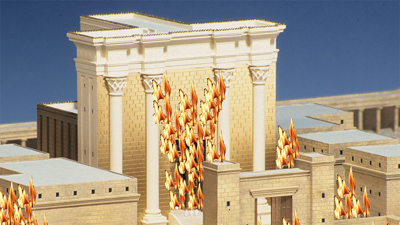
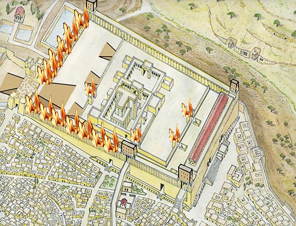
The Roman destruction of the Herodian Temple Mount was a tragedy that is still mourned today. Nevertheless, Josephus’ report about the battle for the Temple Mount, despite its many gruesome details, provides us with many helpful indications about the layout of the Sanctuary and its buildings, courts, porticoes and gates.
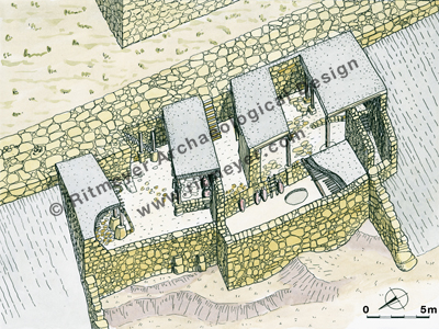
Seven different stages of this war can be observed which confirm the layout of the Temple Mount.
1. First unsuccessful attempt to capture the Antonia Fortress
2. Second successful attempt to capture the Antonia Fortress
3. Construction of a road into the Herodian Outer Court
4. Capture of the square Temple Mount
5. Capture of the Court of the Women
6. Capture of the Temple Court
7. The Destruction of the Temple
To make this information available, we have produced a new presentation consisting of 50 slides which follow these seven different stages of this battle.
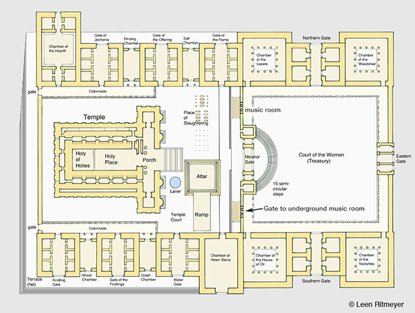
The Location of the Music Chamber in the Court of the Women
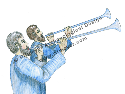
As noted in our previous post, music played an important role in the Temple services. Although the real service of praise in the Temple was done mainly by voice, this was often accompanied by the playing on musical instruments. Silver trumpets were blown by priests to accompany the sacrifices.
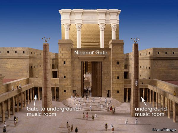
The Levites stood on the fifteen semi-circular steps to sing the Psalm of the day, and on other occasions, all of the fifteen Songs of the Steps, namely Psalms 120-134.
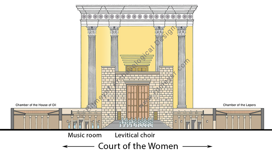
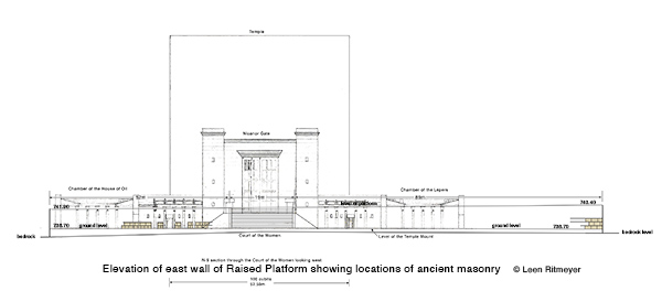
To the east of Herod’s Temple was the large Court of the Women, also known as the Treasury in the Gospels. This court was as far as women were allowed to proceed into the Temple. The Levitical Choir stands on the semi-circular steps.
The number of instrumentalists was not limited, and not confined to Levites only. Middot Arakhin 2.4 indicates that some of these were from the families of Emmaus, another name for Bethel. The musical instruments were kept in a special underground chamber that opened to the Court of Women. We can imagine that when the Levites sang on the steps, the players on harps, trumpets and lyres, stood next to them in front of the Music Chamber.
This Chamber of Music is mentioned in Middot 2:6, “And there were chambers under the Court of Israel, which opened into the Court of the Women, where the Levites played upon harps and lyres and the cymbals and all instruments of music”. I previously speculated that some remains of this music chamber may have survived the Roman destruction of 70 CE.
So, let us examine the archaeological information.
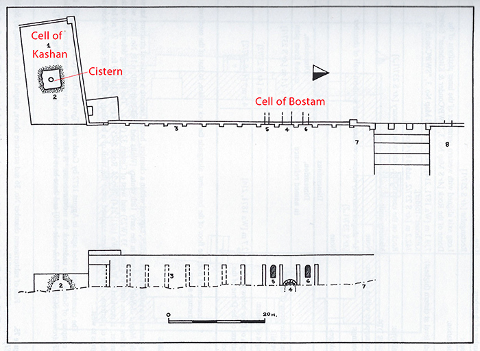
The three openings had already been noticed in the 19th century by Conrad Schick[1] and Warren[2]. Warren noted that there was a hollow space behind the wall, and called it the Cell of Bostam. The name ‘Bostam’ appears to be a corruption of ‘bustan’, a group of trees and vegetation that grew here and which can be seen in some Crusader illustrations. Warren wrote that “in 1881 an attempt was made to obtain permission to open this doorway and explore the unknown cells and vaults. This was not only refused, but a large heap of earth was soon after piled in front of the closed doorway.”
Adapted from Gibson and Jacobson, fig. 74.
For interest’s sake, the structure called Cell of Kashan to the south of the Raised Platform, has a cistern. Schick[3] noted that over this cistern (2 on the plan), the Kashan Mosque, which has long been demolished, once stood.
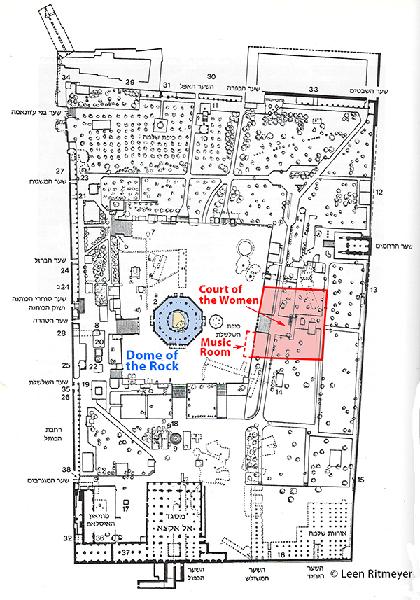
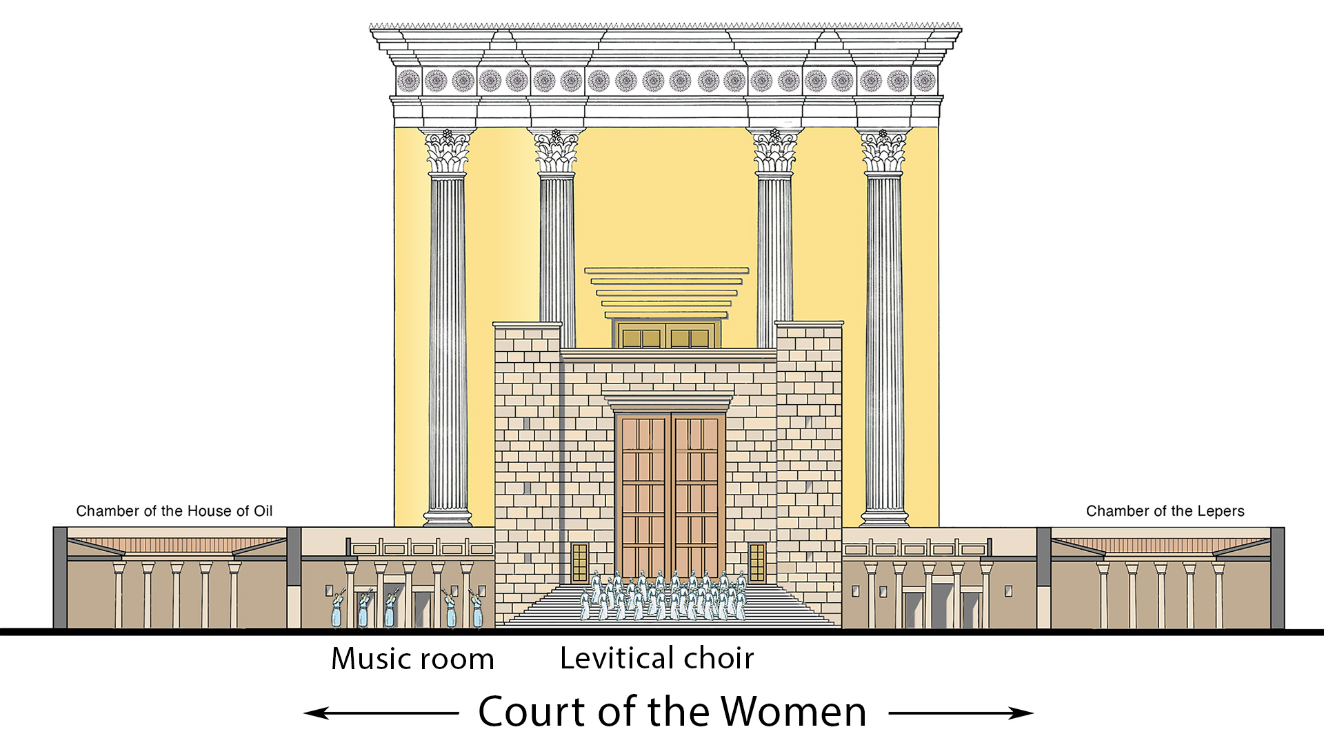
Below is a plan showing the location of the Court of the Women on the present day Temple Mount, followed by updated archaeological evidence we presented in our previous blog.
On this plan of the present Temple Mount, we have drawn the location of the Court of the Women and the underground Music Chamber, or Music Room.
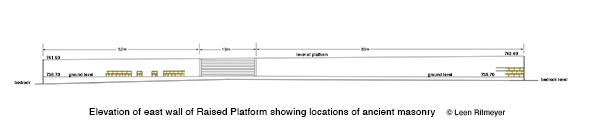
Next, I made an accurate elevation of the ancient stones in the eastern wall of the Raised Platform, showing the ancient stones at the northeast corner, and further to the south, the visible masonry on the sides of the previously mentioned arches.
The surviving stones of the western wall of the Court of the Women have been indicated in this elevation of the eastern wall of the Raised Platform.
To check if this discovery agreed with the description in Middot, I compared the location of this triple entrance with a reconstruction drawing I had made of the Court of the Women for a model I had designed many years ago.
After superimposing the newly discovered masonry on this drawing, I was pleasantly surprised to see that the central opening was exactly where I had drawn it earlier.
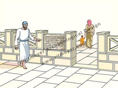
Putting this information together, I was able to draw a reconstruction of the Court of the Women and the Music Chamber, or Music Room. To the left (south) of the Court of the Women was the Chamber of the House of Oil, and on the right (north) was the Chamber of the Lepers.
This drawing shows how music was performed in the Temple of Jerusalem. The Levites stood on the fifteen semi-circular steps that were in front of the Nicanor Gate, to sing Psalms. They were accompanied by the players on harps, trumpets and lyres, who stood next to them in front of the Music Room.
Behind the Levitical choir is the Nicanor Gate, and the Temple towered in the background. The musicians that stood in front of the Music Chamber have now been added to a previous drawing of the Temple Courts.
To the east of the temple stood the Court of the Women (centre front). This large court was known in the Gospels as the Treasury. The Nicanor Gate stood in front of Herod’s Temple. It gave access to the Temple Courts from the Court of the Women. To the left of the Levites are some musicians, dressed in blue, standing in front of the Music Chamber.
It must have been very impressive to hear the choir, accompanied by the musicians playing on their instruments, praising God. They sang different Psalms each day, and on the Shabbat they sang Psalm 92, “It is good to give thanks unto the Lord”.
Now, of course, we can praise God wherever we like, at home or in a congregation, but it is good to remember that acceptable worship was first instituted by King David who wrote the Psalms, which were sung in the subsequent Temples of Jerusalem.
[1] Gibson, S. and Jacobson, D.M., Below the Temple Mount in Jerusalem (1996).
[2] Warren, Ch. and Conder, C.R., Survey of Western Palestine, Jerusalem Volume (Vol. 2), (1884, 219).
[3] Schick, C., Beit el Makdas oder der alte Tempelplatz zu Jerusalem; wir er jetzt ist. (1887, 86)
Could this be the remnant of the gate to the southern underground Music Room?
Here is my translation of an article written on the 4th of October 2020 by Arnon Segal for the Makor Rishon Hebrew newspaper with additional comments and illustrations.
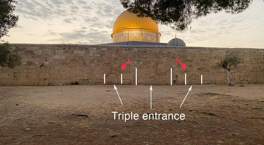
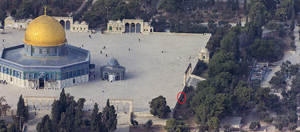
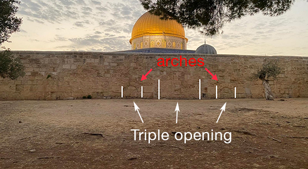
“In the eastern wall of the Raised Platform on which the Nikanor Gate stood during the days of the Temple, two arches were recently discovered that had been blocked at some point. Where did they lead to and who built them? And does this have anything to do with the holiday of Sukkot?”
Location of the discovery. Photo: Eli David
“The eastern wall of the Raised Platform that supports the plaza around the Dome of the Rock, is closely connected with Sukkot (the Feast of Tabernacles, or Booths). According to the Jewish tradition that places the Holy of Holies in the center of the Dome of the Rock, the Nicanor Gate stood on this wall during the days of the Temple. The staircase that descends from it today numbers 25 steps, but originally there were only 15 steps. On the feast of Beit Hashoeva (the Water Drawing ceremony) on the feast of Sukkot, when they went down to draw water from the Pool of Siloam, the Levites stood on these steps and sang the 15 songs of the degrees in the Book of Psalms.”
“This wall is oriented in an almost precise north-south line (a half-degree deviation that may be explained by a certain change in the magnetic north for thousands of years), just as the Temple itself was oriented according to precise astronomical directions. This eastern wall preserves a memory of the most significant difference in height on the ancient Temple Mount, namely that which separated the higher Court of Israel from the lower Court of the Women.”
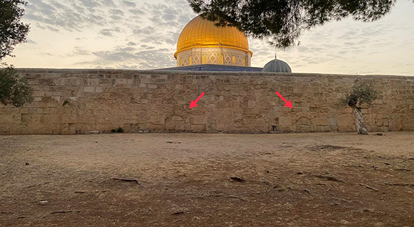
“In recent weeks, Dr. Eli David has noticed two blocked arches on this wall, which as far as is known, are not mentioned in the research literature of the Temple Mount from the 19th century. There seemed to be a passage here that had been blocked at some time in the past. Archaeologist Dr. Leen Ritmeyer, who has been researching the Temple Mount since the 1970s, also did not know these arches, but has now speculated that they were built during the Crusader period or even earlier.”
The arrows show the two arches pointed out by Dr. Eli David
“According to Ritmeyer, the plaza round the Dome of the Rock was probably founded in the seventh or eighth century AD for the purpose of supporting the Dome of the Rock. And yet, it probably also incorporates much older components. At the northern end of this wall there are three courses of ancient construction that also extend along the northern wall of the Raised Platform. In his hypothesis it is possible that this corner served as an end to the soreg which marked the area beyond which foreigners and the unclean were forbidden to enter.”
Three ancient stone courses at the east side of the NE corner of the Raised Platform. Photo: Leen Ritmeyer
Ancient stone courses and offset at the north side of the NE corner of the raised Platform. Photo: Leen Ritmeyer
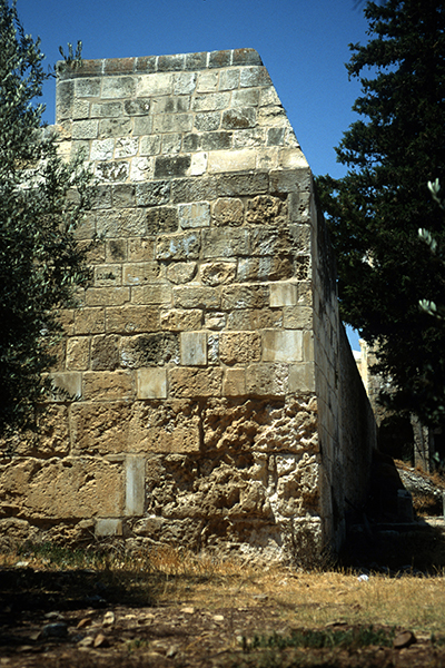
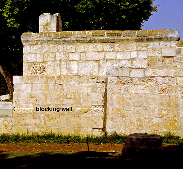
“At the southern end of the eastern wall, there are indications of the existence of additional underground spaces that have been sealed off. In the mid-19th century, the British expedition officer Charles Warren asked permission to explore this space, but the very next day a pile of earth was placed in front of the opening that prevented it, a pile that was later replaced by a stone blocking wall. According to Ritmeyer’s calculations, this was the place of the Chamber of Hewn Stone where the Sanhedrin used to hold court sessions.”
This blocking at the SE corner of the Raised Platform hides the entrance to an underground chamber, that Charles Warren was prevented from entering. Photo: Leen Ritmeyer
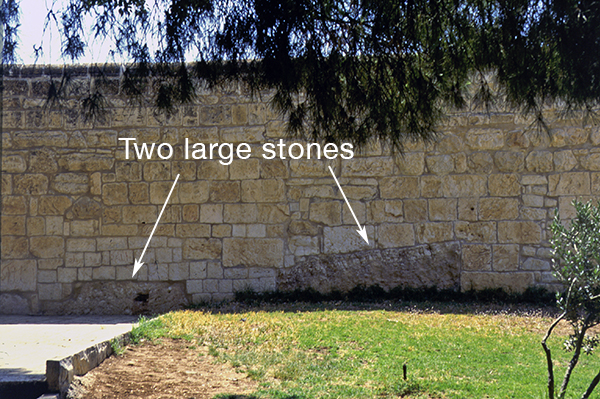
“And this wall has a few more things to tell us. At one point in the wall, north of the stairway, two large stones remain at the base of the wall, which Ritmeyer speculates may have been from the time of Herod and may have served as part of the retaining wall of the Court of the Women.”
Two very ancient large stones on which the smaller stones of the east wall of the Raised Platform were built. Photo: Leen Ritmeyer
“Going back to the blocked arch openings located by Dr. Eli David, Ritmeyer points out that on the sides of these two arches two large stones can be seen that seem to belong to a triple opening. According to Ritmeyer, it is difficult to date the exact style of construction, but in his opinion, these are stones are similar to the ancient stone courses mentioned before, which are located at the northeast corner of the eastern wall. In his estimation, the opening may be from the Crusader period or even earlier. “These architectural remains show that there is still much to explore and discover,” Ritmeyer admits, “not only around the outer walls of the Herodian Temple Mount, but also on the Temple Mount plaza itself.”
“Even if Dr. Ritmeyer assumes that the arches are from the Crusader period, they may have served as an opening to a much earlier underground space. When was it created and by whom?”
“It is not clear, but perhaps one should recall the words of Tractate Middot (2:6) regarding this very place, which indicates that this is the place where the musical instruments of the Temple were stored:
“And there were chambers under the Court of Israel, which opened to the Court of the Women, where the Levites played upon harps and lyres and the cymbals and all instruments of music”. At the Simchat Beit Hashoeva (the rejoicing of the Water Ceremony) that took place on the holiday nights, they played loudly.”
I find it very exciting to speculate that some remains of the entrance to this Music Room may have survived the Roman destruction of 70 AD. It is of special importance that this discovery was made during the days of Sukkot.
Music played an important role during the Feasts of Israel, especially during the present days of Sukkot. Trumpets were used to announce Rosh Hashanah, the beginning of the civil New Year, which fell on the 19th of August 2020. On the 10th of Tishrei, which was the 29th of September, was Yom Kippur, the Day of Atonement. During a Jubilee year, the trumpet of the Jubilee was sounded on the tenth day of the seventh month; on the Day of Atonement you shall make the trumpet to sound throughout all your land. And you shall consecrate the fiftieth year, and proclaim liberty throughout all the land to all its inhabitants. It shall be a Jubilee for you; and each of you shall return to his possession, and each of you shall return to his family (Leviticus 25:9,10).
Every morning of Sukkot at daybreak, a group of Levites and priests went down to the Siloam Pool, which is located south of the Temple Mount, and drew three log (a Talmudic liquid measurement) of fresh water to be poured on the altar after the daily morning sacrifice. Their arrival at the Temple with the water was accompanied by trumpet blasts. (For Shabbat, the water was collected before the onset of Shabbat and stored in a golden vessel in the Temple.) It says in the Talmud: He who has not seen the Water-Drawing Celebration has never seen joy in his life.
Jesus used this act to draw the attention of the spectators to this ceremony when he said in John 7.37–39: “If any man thirst, let him come unto me, and drink. He that believeth on me, as the scripture hath said, out of his belly shall flow rivers of living water.”
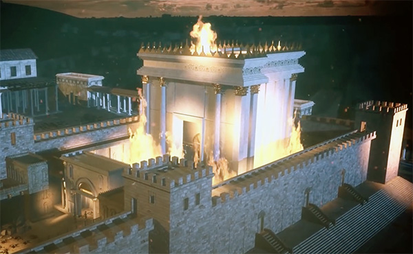
Yesterday was Tisha be’av, the Hebrew date on which the Jewish people remember the destruction of both the First and Second Temples.
In honour of this occasion, Megalim, The City of David Institute for Jerusalem Studies, showed a dramatized recreation (2019) of the Roman destruction of Jerusalem in 70 AD, called:
A Temple in Flames The Final Battle for Jerusalem and the Destruction of the Second Temple. Here is the link to the YouTube video: https://www.youtube.com/watch?v=y5vuoX09ryw
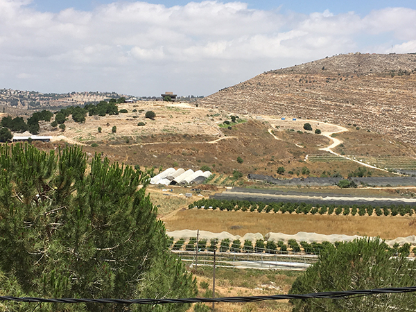
At present, renewed excavations are being carried out under leadership of Dr. Scott Stripling, on behalf of the Associates for Biblical Research (ABR). He said that he answered the call of the prophet Jeremiah, who wrote: “Go now to my place that was in Shiloh … and see! (Jeremiah 7:12) – and so he did! What do we know about Shiloh and what did he and his team find?
Shiloh seen from the north. Drone picture by Gregor Brandson. Used by permission.
Certain places have a soul-stirring quality about them and on visiting them, you feel you are walking through shades of history in company with those who walked before you. Shiloh is one such place. To go back in time to this site that was so significant in the early history of Israel and in the lives of biblical characters such as Hannah and Samuel, is an exciting experience. No other biblical site has a geographical location so accurately described as that of Shiloh. According to Judges 21:19:
“Shiloh, is north of Bethel, on the east ofthe highway that goes up from Bethel to Shechem, and south of Lebonah.”
These directions could be followed today on a GPS or road atlas. Using this description, the American philologistE. Robinson, was able to identify Shiloh with Khirbet Seilun (Tel Shiloh) as early as in 1838, as it matches this geographical description exactly. Ancient sources such as Eusebius and Jerome confirm the accuracy of the identification. Today, this road on which Shiloh is located, is called Highway 60. It is nowadays also called the “Route of the Patriarchs”, as it follows the path of the ancient road that ran along the Central Mountain Range from Hebron to Shechem, that features often in the travels of the biblical patriarchs.
Shiloh in 1967. Photo: Leen RitmeyerShiloh in 2019. Photo: Leen Ritmeyer
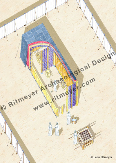
During the wars waged by the Israelites against the Canaanites in the heartland of the country, the Tabernacle and the Ark stayed in Gilgal. Then, we read in the Book of Joshua: “the whole congregation of the children of Israel assembled together at Shiloh and set up the Tabernacle of meeting there.” (Joshua 18:1)
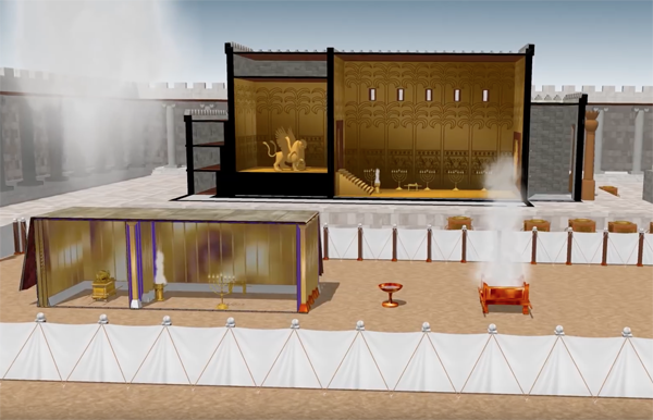
The Tabernacle was surrounded by an open court, formed by 60 pillars with silver capitals and linen curtains in between (Exodus 27). The Tabernacle itself stood at the back of this court with the Laver and the Altar of Burnt Sacrifices in front of it. In this drawing, we see the inside of the Tabernacle. Inside the Holy Place was the Lampstand (menorah), the Table of Shewbread and the Altar of Incense. The Ark of the Covenant stood in the Holy of Holies.
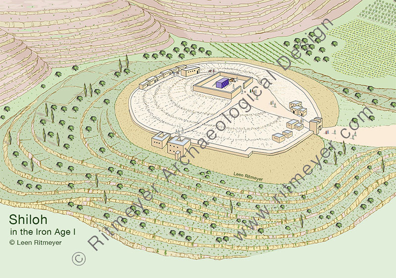
In contrast to many of the sites we have encountered, the site of Shiloh is almost devoid of notable features. All that remains is a small tell of not more than eight acres, secluded at the end of a fertile and quiet valley in the heart of the hill country of Ephraim, (although a thriving Jewish settlement has taken root adjacent to the tell). It was most probably the very seclusion of this site that determined its choice as the new site of the Tabernacle. Here the allotment of territory to the various tribes could proceed unhampered by interference of the Canaanites who still held large areas in their possession further to the north, south and west.
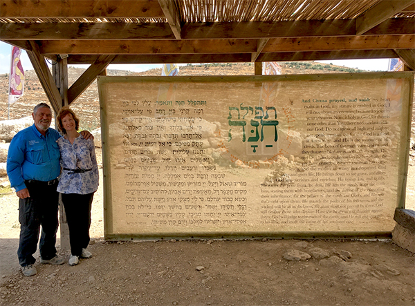
Leen and Kathleen standing next to a screen with Hannah’s Prayer in Hebrew and English.
Shiloh later became the permanent seat of the priesthood. The story of Hannah and Samuel in the first chapters of the Book of Samuel takes place against the background of Eli as High Priest. From these chapters, we get the impression that the Tabernacle was kept in some sort of permanent structure referred to as the “house of the LORD” (Hebrew – beth Yahweh) (1 Sam. 1:7,24 etc.), in contrast to the movable structure which was continually erected and dismantled during the wilderness wanderings. The Mishnah says as much:
“After they came to Shiloh, the high places were forbidden. There was no roof-beam there, but below was a house of stone and above were hangings and this was the ‘resting place’ “ (Zebachim 14.6).
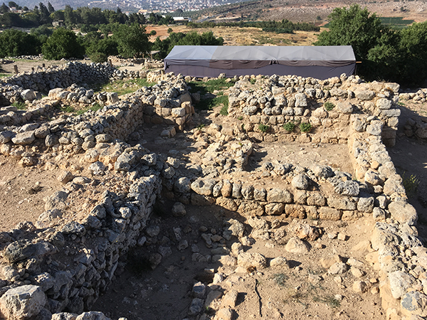
Tell Shiloh was first excavated by two Danish expeditions in the 1920’s and 30’s. Their excavations determined that the site was surrounded by a city wall in the Middle Bronze Age period, and had been destroyed by the Philistines in the mid-eleventh century BC. An Israeli expedition team led by Israel Finkelstein’s team in the 1980’s, made interesting findings on the west of the tell in their so-called Area C. Here they found, as shown in my reconstruction drawing, two Iron Age or Early Israelite buildings built against the outside of the Middle Bronze Age city wall.
During the excavations in Shiloh, an Early Israelite house was excavated near the city wall. Evidence shows destruction by fire. The ritual nature of the objects found in the debris above the destruction level suggested a connection with a cultic complex, perhaps that of the Tabernacle that stood here during the time of the Judges.
These pillared buildings contained an abundance of early Israelite pottery with over twenty of the collar-rim jars (although of a different collar-rim type than the Bronze Age ones) that characterize Israelite settlement in this part of the Land. Evidence that the buildings of this period had been destroyed by fire, confirmed the conclusions of the Danish teams. Because of the ritual nature of the objects found in the debris above the destruction level of these buildings, it was suggested that they stood fairly close to a large structure of a cultic nature on the summit. Can we deduce from this that the Tabernacle stood on the summit?
On the summit of the hill, south of the circular visitors centre, is a flat area the size of the Tabernacle court. Was this the place where it stood beneath these later remains?
Certainty is impossible in view of the destruction of the earlier remains in this area. However, the identification of the tell of Seilun with ancient Shiloh is undisputed and these pillared buildings are authentic remains from the stirring times which saw the erection of the Tabernacle in its new home here in the mountains of Ephraim.
Scott Stripling driving in the first stake in 2016. Photo: Leen Ritmeyer
In June 2016, Scott asked me to help set out the excavation site and be the site architect. In the last three years of excavations, the team has revealed a large stretch of the Bronze Age city wall in the northern part of the tell. Digging between two previous excavations, the continuation of the 5.25m (10 cubits) wide city wall from the Canaanite period with storerooms on the inside, was traced. Storage jars and ritual objects were found in these rooms that were probably associated with a Canaanite temple that had stood at the summit of the hill. These storerooms were organised in units of three underground rooms with a narrower room on one side that served as an entrance from above. The remains of a nearby large structure are also being uncovered, in and near which Israelite sacred objects such as the horn of a stone altar and a ceramic pomegranate were found.
The absence of houses and streets also indicate that this site was used as a cult site for religious gatherings. This site was abandoned at the end of the Middle Bronze Age, in about 1550 BC and remained virtually unoccupied until the end of the 13th century. This appears to have been the time when Joshua gathered the tribes to divide the Land.
It would appear that Joshua took over this site and placed the Tabernacle there, presumably inside the remains of a Canaanite temple courtyard, as the linen curtains of the original court had probably perished by then. Indeed, the text of 1 Sam. 3:15 seems to indicate that this courtyard may have been replaced by a stone wall and possibly an entrance gate. The cultic nature of the site made it therefore possible for the entire community of Israel to gather here for the division of the Land.
It would be wonderful if the location of the Tabernacle site could be determined.
After the Philistine disaster, the Tabernacle was moved first to Nob and then to Gibeon. Scott’s team is not looking for the remains of the Tabernacle itself, of course, but perhaps some remains of the courtyard in which it stood may have survived. Keep digging Scott!
So reads the headline in an Israeli newspaper reporting on an interview about the Temple Mount.
On the 11th of this month, I guided a group of Israeli visitors around the Temple Mount. All of them were highly interested in the Temple Mount for various reasons, some nationalistic and others religious. At the end of the tour, we had lunch together and a journalist interviewed me. His full-page report, with the above title, was published in the Hebrew Makor Rishon newspaper.
You can download the translation of this article with this link:
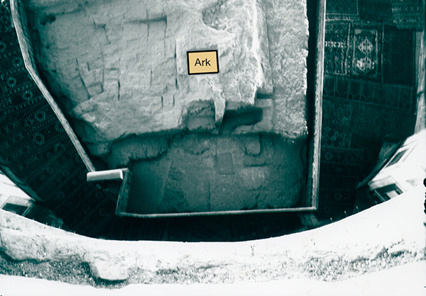
Their main interest was the location of the Temple and the Ark of the Covenant. And as we couldn’t enter the Dome of the Rock, I showed them an old photograph showing the indentation that King Solomon made for the Ark of the Covenant (1 Kings 8.21)
The location where the Ark of the Covenant stood.
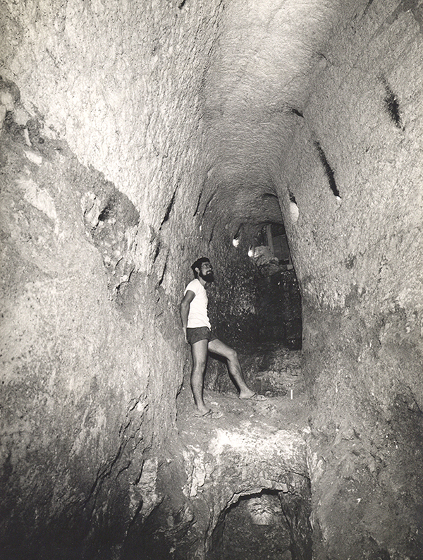
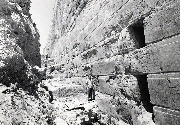
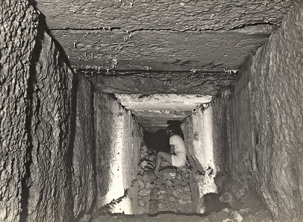
They were also very interested in the underground spaces beneath the mount and published in the newspaper a photograph of a tunnel that was found below the Triple Gate passageway. It was such a peaceful time in the 1970’s, that we had free access to these mysterious places. It was a real privilege to have seen, measured and photographed these spaces, something that would not be possible at present.
In the tunnel below the Triple Gate undeground passageway in 1974. The water that overflowed from an underground cistern was channelled out through this tunnel.
During that time, other tunnels were found running deep below the Double Gate. All these tunnels were closed off after thorough investigation.
This tunnel led from in front of the monumental stairway to the Double Gate to deep below the underground passageway of this gate.
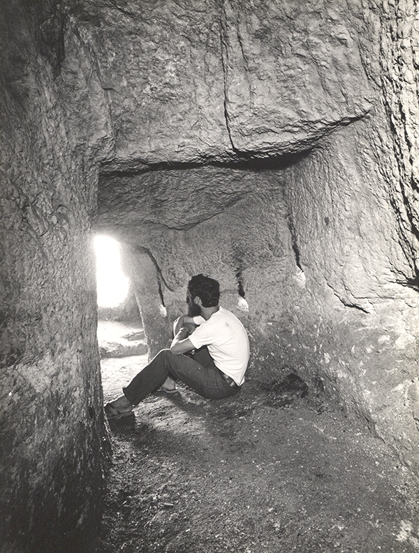
In between the Triple Gate and the southeast corner of the Temple Mount, below the Single Gate that dates from the Crusader period, is another secret tunnel that runs below Solomon’s Stables, that has been converted to a mosque, the El-Marwani Mosque. This tunnel reached to the centre of the Royal Stoa above and may have been used by the workmen who built this edifice.
The entrance to another secret tunnel that ran below Solomon’s Stables. This opening is now blocked up.Inside the tunnel below Solomon’s Stables
Afterwards we talked about the significance of the Temple Mount for Israeli and non-Jewish people alike. For one of the group, the Temple Mount was of nationalistic importance. He had come from Persia, but the reason was to get to know Jerusalem and the Temple Mount, without which, according to him, Israel had no significance.
Another religious Jew said that he couldn’t keep the Mosaic Law without the Temple Mount. I had to agree and said:
“If I were a Jew, I would like to sacrifice the Passover sacrifice on the Temple Mount. Jerusalem has no meaning without the Temple Mount. When I arrived in Israel in 1969, we lived in Gat Rimmon and rented a house from Russian immigrants who had lived in Israel for decades but never visited Jerusalem. I found that hard to understand. Why did you return here if not for Jerusalem and the Temple Mount?”
They wanted to know what, apart from its archaeological importance, the Temple Mount meant for me as a Christian. I answered that Mount Moriah was the place where Abraham was called to sacrifice his only-begotten son Isaac, which, as explained in the Letter to the Hebrews 11:19, was an example of the sacrifice and resurrection of Jesus Christ.
Interview with Eve Harow on her Rejuvenation program
Last week, Kathleen and I were in Jerusalem for the Shiloh Excavations which are directed by Dr. Scott Stripling. On one of the afternoons, Eve Harow of the Rejuvenation programme for The Land of Israel Network interviewed me.
She wrote:
Leen Ritmeyer’s extraordinary journey from Holland to the Temple Mount- and beyond -has defined his life and contributed immensely to ours. He speaks with Eve about the field of Biblical Architecture; how the study of ancient structures in the Land of Israel and Near East enhances our comprehension of history, archeology, the Bible and mankind’s connection to God. He has made an indelible mark in particular on our understanding of Temple Mount transformations thru the millennia and continues to interpret and redefine discoveries both recent and past. This Dutchman is still flying. Listen and learn.
If you have the patience, you can listen to this hour-long interview here:
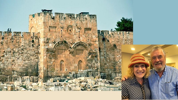
The Golden Gate is very much in the news today, as it has become a point of conflict between Jews and Muslims, or Palestinians and Israelis.
But what do we know about this gate?
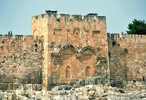
The Golden Gate, around which swirl various traditions, is the most intriguing of all the gates of the Temple Mount. In Jewish tradition, it is through this gate (Sha’ar haRachamim—Gate of Mercy), blocked since the ninth century, that Messiah will enter at the end of days, led in by the prophet Elijah. This is based on the prophecy of Ezekiel 44.1–3. Christians believe that Christ made his triumphal entry into Jerusalem (recorded in all four of the gospels) through this gate on the Sunday before his crucifixion (Palm Sunday). By riding on a donkey, he fulfilled the messianic prophecy recorded in Zechariah 9.9. Muslims refer to it as the Gate of Eternity (Bab-al-Dahariyeh) and believe it will be an important part of the last judgment of mankind. The Muslim cemetery along the Eastern Wall is thought to have been placed there in the belief that the forerunner of Messiah, Elijah, being of a priestly family, could not pass through the Golden Gate, thus preventing the coming of the Messiah.
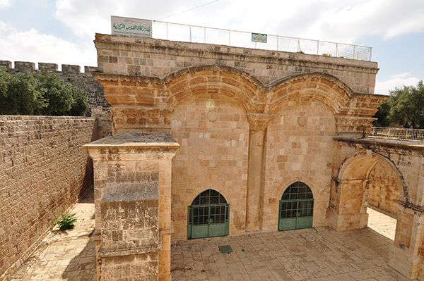
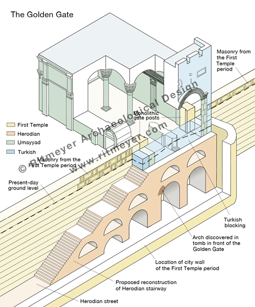
Some claim that the Golden Gate was built by the Byzantine emperor Heraclius after the expulsion of the Sassanians from Jerusalem. However, the absence in the architectural decorations of any Christian symbols, such as a cross makes that difficult to believe. There are actually four distinct historical phases represented in the architecture of this gate: Turkish, Umayyad, Herodian and First Temple period. In the 1970’s I was privileged to spend one week inside this gate, measuring and recording its plan and drawing accurate elevations of all the interior surfaces.
Standing in the middle of the Golden Gate interior. Two monolithic massive gateposts are visible in the far corners.
The Golden Gate’s outer façade is composed of two blocked-up gateways adorned with intricately carved relief arches. The decoration of the arches to the front and back of the gate are identical to the applied arches of the Double Gate which date from the Early Islamic period. The gate appears therefore to have been rebuilt in the Umayyad period, on the foundations of an earlier gate.
The exterior of the Golden Gate in the Eastern Wall of the Temple Mount in Jerusalem. Photo: Leen Ritmeyer
View of the Golden Gate from inside the Temple Mount. Photo: Nathaniel Ritmeyer
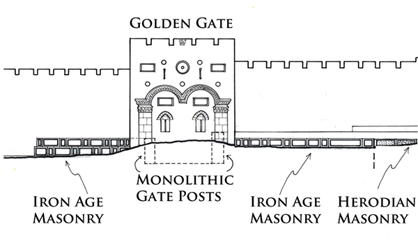
The remains of two massive monolithic gateposts are preserved inside this gate.
The gateposts are set in the same line as the Eastern Wall of the Temple Mount and line up with the massive masonry that can be seen on either side of the Golden Gate.
The gateposts and the two masonry sections appear therefore to be part of the same construction. The top of the southern gatepost is level with the top of the ancient masonry that can be seen south of the Golden Gate. The northern gatepost is one stone course higher and is located only one stone course below the surface of the Temple Mount. This means that the top of the original lintel would have been identical with the present-day level of the Temple Mount. The two gateposts belong to a gate that dates from the First Temple period and is most likely the Shushan Gate, mentioned in Mishnah Middot 1.3 as the only gate in the Eastern Wall.
The gate most probably was given this name by builders who had returned from exile in Babylon and for whom the Palace of Shushan lived on in their memories. However, if so there would have been a tradition of an eastern gate in this location from the time of the construction of the original Eastern Wall. It seems reasonable to suggest that the central section of the Eastern Wall dates from the First Temple period, in particular to the time of King Hezekiah. This square mount was extended south in the Hasmonean period, while both the southern and northern additions were made by King Herod the Great.
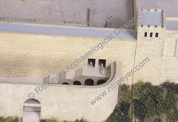
In 1969, the remains of an underground arch were discovered inside a grave in front of the Golden Gate. It was suggested that this may have been a pre-Herodian gateway. However, as the arch stones appear to be Herodian, it is more reasonable to suggest that this arch was part of a Herodian staircase leading up to the original gate. It is fascinating to contemplate that the stairway may still be intact under this gate, although hidden from sight by the Muslim Cemetery.
We do know that the remains of an ancient city wall lie under the present-day path that runs through the Muslim cemetery, which was discovered by Warren in the 1860s. The above-mentioned arched stairway led down through a gate in this city wall, the so-called Miphkad (Muster, or Inspection) Gate mentioned in Nehemiah 3.31, apparently still in use in the Second Temple period. During the latter period, it was through these gates that the Red Heifer was led out from the Temple Mount to the Mount of Olives (Mishnah, Parah). On the Day of Atonement, the scapegoat was led by the same route into the wilderness (Mishnah, Yoma).
It is therefore obvious that the Golden Gate is a very important historical building for the Jewish people, as reported by Arnon Segal of the Hebrew newspaper Makor Rishon Here is a translation of the article that refers to my research:
Just over two years ago, I wrote a post, reporting on a 3D model of Solomon’s Temple, created by Daniel Smith. Last week he told me that he had just released a new video, which is called “Solomon’s Temple Explained”. He is happy for me to share it with you.
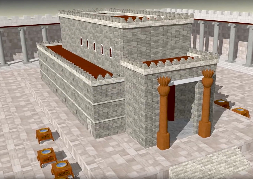
Solomon’s Temple stood in Jerusalem for almost 400 years. It was the crown jewel of Jerusalem, and the center of worship to the Lord. Understanding the significance of its location, history, and design can greatly add to one’s reverence for one of the most holy places in the world,
Special thanks to: Brian Olson for the beautiful 3D Solomon Temple renders. Michael Lyon for his design elements and feedback of the Temple model. Leen Ritmeyer for his excellent books and personal help. Cantorum Chamber Choir for allowing me to use their music.
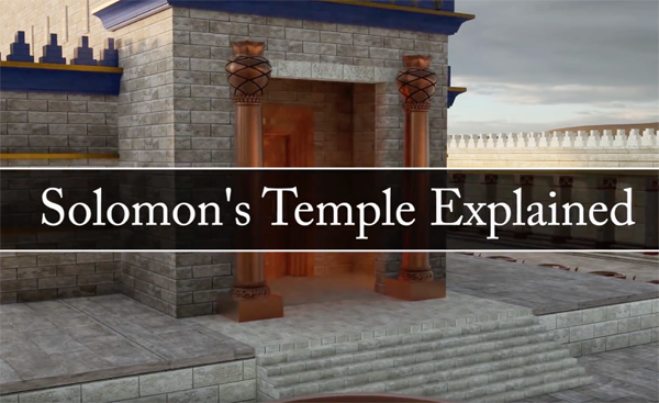
This excellent new video begins by explaining the topography of Jerusalem and how the City of Solomon’s location was determined by the surrounding mountains and valleys. The topographical and biblical importance of Mount Moriah is explained.
The expansion of the City of Jerusalem in the time Solomon.
The video includes a section on the Tabernacle which served as a blueprint for Solomon’s Temple. After showing that Solomon built the Temple on Mount Moriah where David previously had purchased the threshingfloor of Araunah the Jebusite, he goes back to the Book of Genesis and explains the symbology of the events that took place in the Garden of Eden.
The design of Solomon’s Temple was based on the Tabernacle, shown here in the foreground.
The video then shows that Solomon’s Temple replicated the same three-level progression as found in the Garden of Eden and the Tabernacle. The ultimate aim of its design was to show how people could return to God. The video ends with the Sacrifice of Christ.
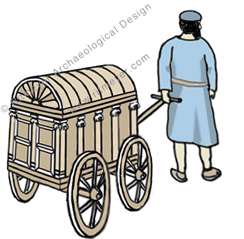
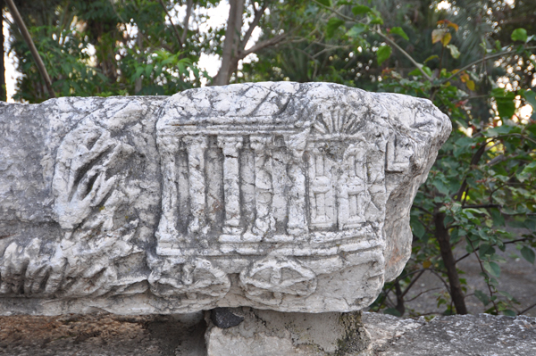
The reconstruction drawing that illustrated our previous post, which described the 1st century synagogue of Capernaum, includes a figure pulling a small ornate carriage towards the entrance of the building.
Is this vignette just an artistic flourish or does it have a historic basis? In this post, we hope to show that ancient sources and evidence from one of the architectural fragments found scattered on the site of Christ’s “own city” (Matthew 9.1), make it reasonable to assume that such a device was once used to transport the precious scrolls of the Law to the synagogue from a place where they were stored safely.
But firstly we must release the element (pictured below) from the layers of misidentification it has accrued since it was first displayed on a wall by the Franciscan custodians of the site, together with other elements of a frieze that originally adorned one of the walls of the later (Byzantine) synagogue.
A carved stone on a frieze that came from the Byzantine Synogogue in Capernaum shows a wheeled shrine, decorated with a double winged panelled door, topped by a scallop. The side has five pillars as in an Ionic temple, while the roof is convex.
I have lost track of the number of times, on visits to the site, that I have heard tour guides explain to their group: “this is a model of the Ark of the Covenant made by Moses and carried for 40 years in the wilderness.” A well-known tour company has a photo of this stone on their website with the caption “Stone carving of Ark of the Covenant at Capernaum” (now amended since this post) and this is repeated many times, for example by Tripadvisor.
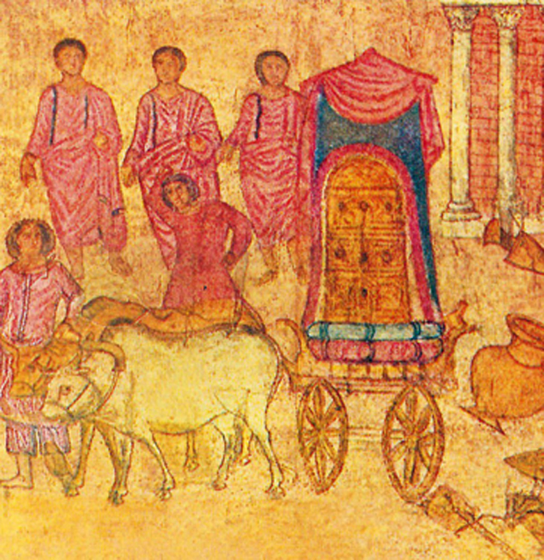
An easy explanation – but could it be true? Opinions vary greatly, even among scholars. This is partly due to the lack of comparative material. There is one illustration from the Dura Europos Synagogue that shows the Ark on a wheeled cart, but that was the Ark of the Covenant as it was sent back on a cart by the Philistines (1 Samuel 6:7) and therefore cannot be used as a parallel:
This fresco from Dura Europos shows the Ark of the Covenant placed on a cart by the Philistines.
There is an insight in the book “Capernaum”1 by Sapir and Ne’eman (pp 63, 64) into the dichotomy between two religious requirements of the synagogue: “the first religious demand was – and still is – to focus the attention of the whole praying congregation on the Ark of the Law – (aron hakodesh) containing the scrolls of Torah. Another independent demand, no less imperative – was to orientate the synagogue toward Jerusalem” … “If the Ark were permanently built in the south wall or a little before it, the view towards Jerusalem would be blocked for ever. If, on the contrary, the Ark of the Law were arranged on the blind doorless north wall,the worshippers would have to turn their backs on Jerusalem -which was considered a blasphemy.”
A passage in Mishnah Taanit 2:1 may explain how a solution to this problem was found: “They used to bring out the Ark [containing the Scrolls] into the open space in the town”. Although this was done during times of fasting, it nevertheless shows that the Torah scrolls were sometimes transported from a place, such as the home of the archisunagogos, as the ruler of the synagogue is called in the New Testament, to the synagogue and back again. Continue reading “Is the Ark of the Covenant depicted on a carved stone at Capernaum?”