I have been asked by a few readers to clarify my position on the location of the Akra, that hated symbol of alien Hellenistic rule whose occupiers became in the words of the writer of the First Book of Maccabees: “a great trouble … an ambush for the sanctuary, an evil adversary for Israel at all times” (1. 35 – 38). This was because they attacked the Jewish worshippers that went up from the city to the Temple.
Let me say, first of all, that the finds in the Givati Parking Lot (announced on November 3rd) and identified as part of the Akra, are very significant. According to the excavators, a 4m wide and 20m long defensive wall dating to the Hellenistic period was found with a glacis, made up of soft layers of rubble, descending to the bottom of the Tyropoeon Valley. This therefore indicates that this wall was part of the western fortifications of Hellenistic Jerusalem. The difficulty is to establish what part of the Hellenistic city this wall belongs to. Now that the media pundits have regurgitated the news announcement, it is time to reflect on this latest identification of the Seleucid Akra.
The most important information about the Akra comes from two historical sources, namely the works of Josephus and the above mentioned First Book of Maccabees. The problem with these sources is that they are not easy to harmonise. However, we must not shy away from them, but try to interpret them in the light of these and other archaeological findings. First to quote from the previous verse from the Book of Maccabees to the one above.
“And they built the city of David with a great and strong wall, and with strong towers, and made it a fortress [Greek: Acra] for them: And they placed there a sinful nation, wicked men, and they fortified themselves therein.”
This quote shows us that the City of David, which is the southern part of what Josephus calls the Lower City (see map), was fortified all around to turn it into a fortress.
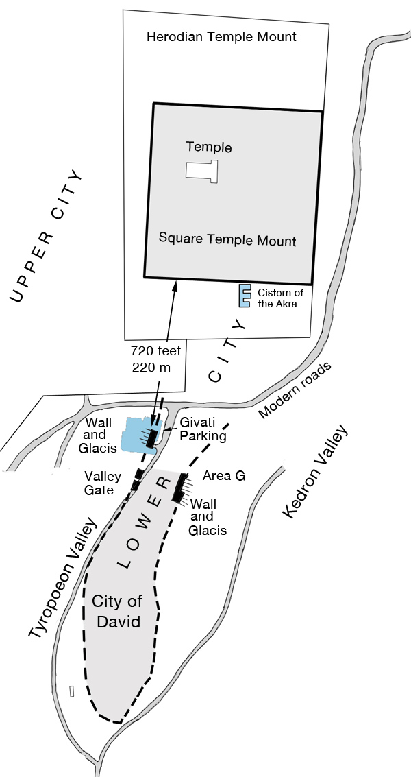
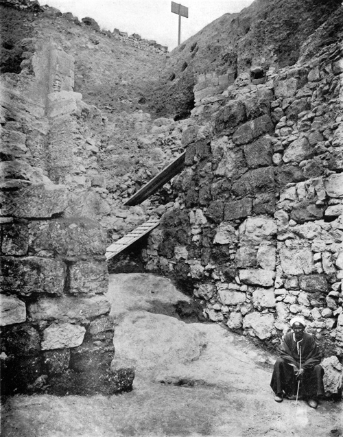
This does not mean that the City of David was the Akra Fortress, but that it was as strongly fortified as a stronghold. The wall in the Givati Parking Lot belongs to the western fortifications. Interestingly, it is in direct line with the Valley Gate that was excavated a little further south by J.W. Crowfoot in 1927. This excavator was of the opinion that this wall section with its gate belonged to an early period and was restored probably during the time of Nehemiah and certainly in the Maccabean period*.
On the eastern side, a similarly strong wall with a glacis was excavated by Yigal Shiloh in the excavations he carried out in the City of David from 1978 – 82.
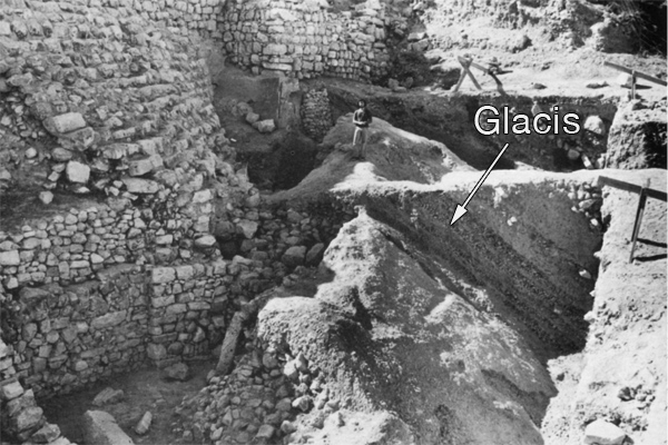
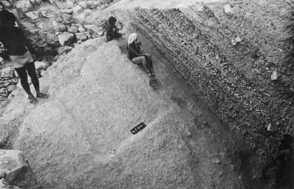
These excavated wall sections, both in the west and in the east, were all part of the fortifications of the City of David in the Hellenistic period (c. 300 B.C. – 141 B.C.). These walls would have continued further north and were connected with the Temple Mount.
The Temple Mount at that time still had the 500 cubit square shape that was given it in the First Temple period, probably by King Hezekiah. The square mount was rebuilt by Nehemiah and continued to exist in this form until the Hasmonean period (141 B.C. – 37 B.C.).
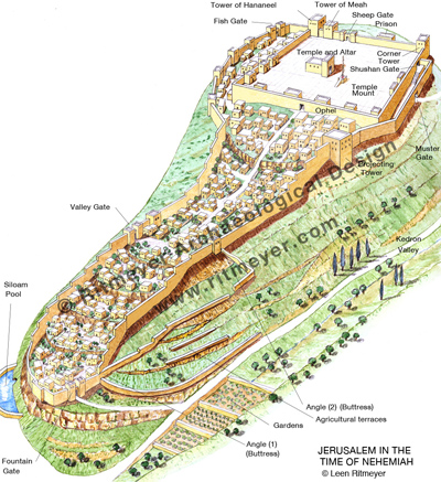
In this annotated drawing we see the rebuilt city of Jerusalem on the Eastern Hill with a smaller Temple on Mount Moriah. The reconstructed Temple Mount had gates and towers and chambers along the inside of its boundaries. The Ophel was to the south of the Temple. The city walls have been reconstructed following archaeological remains that have been found, complemented by the description of the walls in Nehemiah Chapter 3.
The other main source on the Akra, Josephus, tells us that, apart from fortifying the City of David, a separate fortress or citadel was also built by the Seleucids next to the Temple Mount:
“…and when he had overthrown the city walls, he built a citadel [Greek: Acra] in the lower part of the city, for the place was high, and overlooked the temple; on which account he fortified it with high walls and towers, and put into it a garrison of Macedonians”, Antiquities of the Jews 12:252–253
This quote from Josephus speaks of a citadel that was built in the highest place of the Lower City. What did the term “Lower City” mean in the time of Josephus? In describing the City of Jerusalem, Josephus (War 5.136-141) describes two hills, the upper city which had a straight ridge and was higher than the Lower City. The Upper City was located on the Western Hill of Jerusalem (where the Jewish and Armenian Quarters are today). The Lower City, which bore the name of Akra and was shaped like a hog’s back, was located on the Eastern Hill south of the Temple Mount. The valley in between the Western and Eastern Hills is called the Central or Tyropoeon Valley.
It is important to make a distinction between the Lower City that was built like a fortress (akra) and the separate citadel or fortress itself that was called the Akra. The two, the city and the citadel, are not the same in the historical sources. This is made abundantly clear in the Book of Maccabees, where it is recorded that Jonathan “decided … to erect a high barrier (wall) between the Akra and the city, to separate it from the city and isolate it” (1 Macc 12:36). The Akra citadel therefore clearly stood in between the city and the Temple.
Let us now concentrate on the citadel named the Akra. What do we know about it?
Antiochus IV Epiphanes built the Akra in 168 B.C., a fortress for his Macedonian garrison from which the Jewish population could be controlled. Josephus records that it “commanded or overlooked the Temple”. Josephus writes in Antiquities 12.252 that Antiochus:
“… built the Akra in the Lower City; for it was high enough to overlook the Temple, and it was for this reason that he fortified it with high walls and towers, and stationed a Macedonian garrison therein. Nonetheless there remained in the Akra those of the (Jewish) people who were impious and of bad character, and at their hands the citizens were destined to suffer many terrible things.”
This is later confirmed by Josephus (Ant.12.362):
At this time the garrison in the Akra of Jerusalem and the Jewish renegades did much harm to the Jews; for when they went up to the Temple with the intention of sacrificing, the garrison would sally out and kill them—for the Akra commanded the Temple.
The Akra fortress therefore must have stood close to the Temple and overlooked it. The Temple Mount of that time was smaller than the present-day Temple Mount. In the Hellenistic period the Temple Mount still had a square shape, as it had in the time of Nehemiah. The distance between the Givati excavations and the southern wall of the square Temple Mount is 720 feet (220m) and the excavations are lower by some 150 feet (50m). It is impossible for the Akra fortress to have been situated in that location as it is too far from the Temple Mount and too low. The Seleucids would have had to construct a skyscraper of more than 150 feet (50m) in height, the approximate height of an 18 storey high modern building or the Temple in the time of Herod the Great. In the quote above of War 5, Josephus continues to inform us that the Hasmoneans:
“filled up the valley, with the object of uniting the city to the Temple, and also reduced the elevation of Acra by leveling its summit, in order that it might not block the view of the temple.”
In our previous quote we mentioned that Josephus also wrote that after Simon the Maccabee had razed the Akra, he “thought it would be an excellent thing and to his advantage to level also the hill on which the Akra stood, in order that the Temple might be higher than this” (Ant. 13.215).
It reasons therefore that the Akra was totally destroyed and dismantled and the ground on which it stood was leveled. As Josephus records that it took three years to raze the Akra and the promontory of the Lower City on which it stood, I believe therefore that it would be impossible to ever find any remains of this fortress.
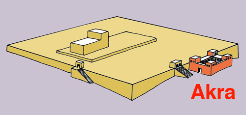
Josephus further confirms (Ant. 12.406) that the Akra was built adjacent to the Temple Mount as he states that “Nicanor was coming down from the Akra to the Temple.”This clearly shows that the Akra must have been built very close to the Temple Mount, if not right up against it, see drawing below reproduced from my previous post.
The Akra was a formidable fortress with a garrison permanently stationed in it. It was therefore necessary to have a good water supply. Adjacent to the projected southern wall of the square Temple Mount is a curiously shaped cistern. Its plan is in the form of the letter E, which is unlike all the other, mainly irregularly shaped, cisterns of the Temple Mount. This Cistern 11 was explored by Warren and described by Conder as follows,
It is 61 feet 6 inches (18.75 m) deep and consists of three tanks, each about 26 feet (7.9 m) by 40 feet (12.2 m) connected by a passage running north and south and 14 feet (4.30 m) wide. The total contents are about 700,000 gallons (3,200 m3). The roof is of rock cut out into arches. Steps on the west ascend to the mouth of the tank and west of these are foundations of a massive wall on the rock. The passage from the Triple Gate is continued, so as to run over this tank.
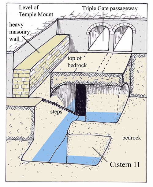
This tank is located just south of the square Temple Mount, in an area that is totally flat and its position suggests that it was specially cut to provide the Macedonian garrison stationed in the Akra with a water supply ample enough to withstand a long siege. Stones quarried from this cistern may initially have provided building material for the Akra.
Interestingly, the tractate Erubin of the Mishnah calls one of the cisterns of the Temple Mount be’er haqqer. This name, which means “The Cistern of the Akra,” suggests that one of the cisterns of the Temple Mount was named after the fortress that lay on top of it. In addition, the presence of the foundations of a massive wall in this cistern, described by Warren, together with the cistern’s peculiar E-shape, suggest a design that would support a large building.
The literary evidence, combined with the unusually shaped Cistern 11, provides the first tangible evidence for the location of the Akra in the northern part of the area between the Double and Triple Gate passageways.
The finding of the Hellenistic city wall with its glacis in the Givati Parking lot has contributed much to our understanding of Jerusalem in the pre-Hasmonean period. This wall, however, belongs to the city walls of that time and has nothing to do with the infamous citadel of the Akra.
* J. Simons, Jerusalem in the Old Testament (Brill, 1952), 90.

wow wow wow! thanks for the great article!
if only 00.1 percent of the media out there would put your info for the public…
the public r such innocent ‘false info’ lovers [sorry public out there :(, u wont even read this :)], they love nice large headers, real life info doesnt give them any comfort.
Mr Ritmeyer,
There is a passage from Flavius Josephus “The Wars of the Jews” 6:354 that is open to reinterpretation in the light of the IAA press release about the Acra.
“but on the next day they set fire to the repository of the archives, to Acra, to the council-house, and to the place called Ophlas; at which time the fire proceeded as far as the palace of queen Helena, which was in the middle of Acra”
How about “the palace of queen Helena, which was built in the middle of & upon the ruins of the Selucid Acra”? ”
Even were the name “Acra” applied to an entire Hellenistic quarter rather than to only a fortress, it is likely that a citadel would have stood within that compound to billet the Macedonian garrison which occupied it. It was normal for an Hellenistic city to have a fortified stronghold at or near the highest point of its walled area.”
Sievers, Joseph (1994). “Jerusalem, The Akra, and Josephus” in Parente & Sievers. Josephus and the History of the Greco-Roman Period. Amsterdam, Netherlands: Brill. ISBN 978-90-04-10114-2
The Seleucid Akra had been destroyed more than 200 years earlier and the hill on which it stood made lower than before. I fail to see the connection between this “Akra”, which merely means “fortress” and the one mentioned in the Book of Maccabees.The Palace of Queen Helena was in the middle of the Akra, which can only mean the fortified Lower City as Josephus called the lower slopes of the Eastern Hill.
Dr. Ritmeyer,
Please accept my apologies for using the incorrect form of address in my previous comment. If I understand you correctly, you refute the findings of the IAA archaeologists in their claim to have discovered the remains of the Seleucid Acra at the Gi’vati dig. That’s an interesting POV; of a type that a British politician would term “courageous.” https://www.youtube.com/watch?v=ik8JT2S-kBE
Josephus wrote: ” They then took off part of the height of Acra, and reduced it to be of less elevation than it was before, that the temple might be superior to it.” That suggests to me that the upper courses of stone were taken down, however, the foundations were not dug out, but were filled in whilst the Tyropoeon Valley was being filled & levelled by the Hasmonean dynasty, They were there to be found, hence the announcement of their rediscovery.
Josephus reversed the sequence of events. The Acra citadel was reduced in height & following that demolition, the Tyropoeon Valley was filled with earth gathered from the most southerly section of the Eastern Hill/City of David, which was also once termed Acra, thus creating confusion! It’s what builders do. Tell them to demolish a building & they’ll do as little work as possible to satisfy the site foreman.As always, they’ll hide their short cuts under the topsoil & hope to pull the wool over the eyes of the architect.
The eternal conundrum. How low can you go? How low do you need to go? 🙂
With regard to the location of Queen Helena’s palace, I think your judgement is too harsh. No self respecting queen is going to erect her palace in the tail end of the Eastern Hill. Near or on the relocated Mt Zion, in the rich Upper City is where she would seek to live. Doron Ben-Ami earned his PhD at the Hebrew University of Jerusalem where he is a member of the Institute of Archaeology. In the absence of evidence to the contrary, I shall continue to accept his assertion that her palace was found in the Gi’vati dig
Perry, the clip of “Yes, Prime Minister” is very funny. At least I don’t have to worry about elections! When discussing the Akra Fortress, it is important to take all of the historical passages into consideration, many of which are not easy to interpret. A distinction must be made between the Akra Fortress and the Lower City which is also called Akra by Josephus. However, when Josephus states that the Akra Fortress overlooked the Temple Mount, it must have been a lot closer to the Temple Mount than the Givati Parking Lot dig. Josephus also mentions that Nicanor came down from the Akra to the Temple, another indication that it must have stood adjacent to the Temple Mount of that time. I do not disrespect Doron, but don’t agree with his conclusions. I have also worked at the Hebrew University for many years with Professors Benjamin Mazar, Nahman Avigad, Yigael Yadin and many more. These great scholars taught me how to evaluate historical descriptions against the archaeological evidence, of which the latter must take precedent. Benjamin Mazar previously proposed that the palace of Queen Helena was located in the southeastern part of the Temple Mount Excavations. Doron puts it some 100 meters further to the west. Neither excavators have shown conclusively that they found this historical building. They knew that Josephus wrote that the palace was located in or near the Opel (War 5.253, 6.354). Of course, any archaeologist likes to find famous buildings as it may enhance their reputation, but one needs to be very careful making statements about their discoveries that have not been sufficiently proven.
Dr. Ritmeyer,
I am curious to know why you answered my comment of November 24, 2015 at 7:19 am, but you did not reveal what I had written about the Acra. Is it that what I wrote made such good sense to you that you felt the need to suppress my ideas? If that is not the case, then restoring my comment will enable others to understand the context of your reply of November 24, 2015 at 8:56 am. When both sides of a discussion are published, the authors show they have nothing to hide nor fear.
Perry originally wrote:
“Dr. Ritmeyer,
Please accept my apologies for using the incorrect form of address in my previous comment. If I understand you correctly, you refute the findings of the IAA archaeologists in their claim to have discovered the remains of the Seleucid Acra at the Gi’vati dig. That’s an interesting POV; of a type that a British politician would term “courageous.” https://www.youtube.com/watch?v=ik8JT2S-kBE
Josephus wrote: ” They then took off part of the height of Acra, and reduced it to be of less elevation than it was before, that the temple might be superior to it.” That suggests to me that the upper courses of stone were taken down, however, the foundations were not dug out, but were filled in whilst the Tyropoeon Valley was being filled & levelled by the Hasmonean dynasty, They were there to be found, hence the announcement of their rediscovery.
Josephus reversed the sequence of events. The Acra citadel was reduced in height & following that demolition, the Tyropoeon Valley was filled with earth gathered from the most southerly section of the Eastern Hill/City of David, which was also once termed Acra, thus creating confusion! It’s what builders do. Tell them to demolish a building & they’ll do as little work as possible to satisfy the site foreman.As always, they’ll hide their short cuts under the topsoil & hope to pull the wool over the eyes of the architect.
The eternal conundrum. How low can you go? How low do you need to go? 🙂
With regard to the location of Queen Helena’s palace, I think your judgement is too harsh. No self respecting queen is going to erect her palace in the tail end of the Eastern Hill. Near or on the relocated Mt Zion, in the rich Upper City is where she would seek to live. Doron Ben-Ami earned his PhD at the Hebrew University of Jerusalem where he is a member of the Institute of Archaeology. In the absence of evidence to the contrary, I shall continue to accept his assertion that her palace was found in the Gi’vati dig.”
Perry,
I don’t know why your comment doesn’t show. I did not suppress it and must be the result of a techinal problem, perhaps due to the youtube link. I copy it here again (without the link):
“Please accept my apologies for using the incorrect form of address in my previous comment. If I understand you correctly, you refute the findings of the IAA archaeologists in their claim to have discovered the remains of the Seleucid Acra at the Gi’vati dig. That’s an interesting POV; of a type that a British politician would term “courageous. Josephus wrote: ” They then took off part of the height of Acra, and reduced it to be of less elevation than it was before, that the temple might be superior to it.” That suggests to me that the upper courses of stone were taken down, however, the foundations were not dug out, but were filled in whilst the Tyropoeon Valley was being filled & levelled by the Hasmonean dynasty, They were there to be found, hence the announcement of their rediscovery.
Josephus reversed the sequence of events. The Acra citadel was reduced in height & following that demolition, the Tyropoeon Valley was filled with earth gathered from the most southerly section of the Eastern Hill/City of David, which was also once termed Acra, thus creating confusion! It’s what builders do. Tell them to demolish a building & they’ll do as little work as possible to satisfy the site foreman.As always, they’ll hide their short cuts under the topsoil & hope to pull the wool over the eyes of the architect.
The eternal conundrum. How low can you go? How low do you need to go? 🙂
With regard to the location of Queen Helena’s palace, I think your judgement is too harsh. No self respecting queen is going to erect her palace in the tail end of the Eastern Hill. Near or on the relocated Mt Zion, in the rich Upper City is where she would seek to live. Doron Ben-Ami earned his PhD at the Hebrew University of Jerusalem where he is a member of the Institute of Archaeology. In the absence of evidence to the contrary, I shall continue to accept his assertion that her palace was found in the Gi’vati dig”
where can i get a blueprint of the temple? can i get a map that would show where the temple was located overlying the present map of the city of david?
thank you
bill taylor
Bill,
We have blueprints of Solomon’s and Herod’s Temples and other information available in our Image Library and also in our books which you can see on our website.
BTW, the Temple didn’t stand in the City of David, but on Mount Moriah, see: 2Chronicles 3:1
Bill,
We have blueprints and other information available in our Image Library and also in our books, see:
Solomon’s Temple: http://store.ritmeyer.com/catalog/36
Herod’s temple http://store.ritmeyer.com/catalog/39
Relation to Dome of the Rock” http://store.ritmeyer.com/node/576
Herod’s Temple plan superimposed of the present-day Temple Mount: http://store.ritmeyer.com/node/582
Temple in relation to the Old City: http://store.ritmeyer.com/node/535
Books:
https://www.ritmeyer.com/online-store/books/the-quest-revealing-the-temple-mount-in-jerusalem/
https://www.ritmeyer.com/online-store/books/jerusalem-the-temple-mount/
BTW, the Temple didn’t stand in the City of David, but on Mount Moriah, see: 2Chronicles 3:1
Perhaps for the first time we are in complete agreement on a subject related to the Temple of Jerusalem – in this case concerning the question of the location of the Seleucid Akra fortress. Your analysis is virtually identical to mine in D.M. Jacobson, ‘The plan of Herod’s Temple,’ Bulletin of the Anglo-Israel Archaeological Society 10 (1991-92), 36-66 at 51-54.
Regards,
David
David,
That is nice to know.
Incredible information here Leen! Thank you for your years of hard work into these things. I’ll be studying your work for along time. So appreciative!