I am guessing that some, if not all, of the readers of my blog may be interested to see the latest book[1] to which I had been asked to contribute.
The authors, Brandon Benzinger and Adam Day, are to be commended to have tackled the problem of finding jobs for graduates of Biblical and Theological Study programs. As fewer and fewer jobs are available to them, the editors understood that to get employment, these candidates must think outside the box.
They asked 25 people who have found satisfying jobs to share their experience of how they settled into their present occupation, the ways in which they have used their biblical training in that occupation, the “joys” and “trials” of their work, and advice for those who would like to follow in their footsteps.
The book is divided into four parts:
Part 1: Academia
Part 2: Publishing and Media
Part 3: Congregational Ministry
Part 4: Parachurch Ministry, Missions, and Public Service
I would love to have had this book available at the beginning of my career, rather than nearer the end of it.
Personally, I can’t wait to read the contributions of Steve Ortiz and Mark Wilson, who are closest to my field of work, but I think that I will be quite amazed how interesting I will find many of the characters whose professional dreams are portrayed here.
My chapter in Part 2 is called “Design and Illustration”, in which I set out the various roads I have followed and to see how biblical studies can be a springboard to not just one but possibly a few different careers.
It is interesting to note that those who show the highest level of satisfaction are those with supportive familes.
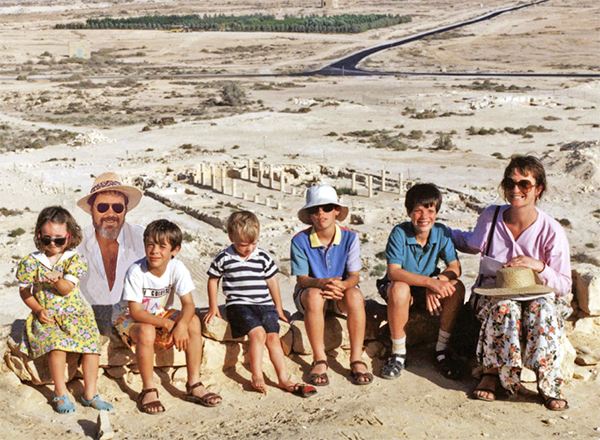
Personally, I am very thankful that my work has also brought me many joys, chiefly in that I have been able to share it with my wife Kathleen, a trained archaeologist. Her excellent writing and research skills have enabled us to produce books and various other educational materials that people still find useful today. When my family was young, I was often able to take them on digs and give them some memorable experience. When they were older, they helped me at times with photography, cartography, and illustration.
Our young family at the Tel Nitzana Excavations in the Negev on the border of the Sinai desert
And, of course, some of the most exciting moments in my career were the making of major discoveries, such as the placement of the ark of the covenant on the Temple Mount, the identification of the Middle Gate mentioned in Jeremiah 39:3, and the main gate of Sodom, where Lot sat (Gen. 19:1).
I warmly recommend this book to all those seeking alternative employment in this ever shrinking field.
[1] Brandon C. Benzinger and Adam W, Day, editors, What CanYou Do with Your Bible Training? Traditional and Nontraditional Vocational Paths, Resource Publications, Eugene OR, 2023.
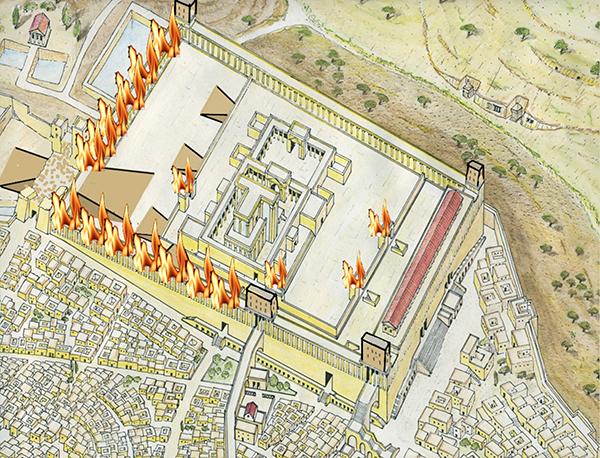
Josephus Flavius, also known as Yosef Ben Matityahu, was an eye-witness to the siege of Jerusalem. He somehow survived the siege of Yotvat in Galilee and with one of his soldiers surrendered to the Roman forces in July 67 CE. The Roman forces were led by Flavius Vespasian and his son Titus, both subsequently Roman emperors. Two years later, Josephus was released (cf. War IV.622-629) and according to his own account, he appears to have played a role as a negotiator with the defenders during the Siege of Jerusalem in 70 CE. The works of Josephus provide crucial information about this First Jewish-Roman War. Here, we would like specially to examine his account of the Roman destruction of the Temple Mount in Jerusalem.
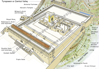
In 19 B.C.E. the master-builder, King Herod the Great, began the most ambitious building project of his life, the rebuilding of the Temple in lavish style. To facilitate this, he undertook a further expansion of the Hasmonean Temple Mount by extending it on three sides, to the north, west and south. The former extension required the filling in of a deep valley to the north of the pre-Herodian Temple Mount. The Shushan Gate remained the only gate in the Eastern Wall. Towers were erected at each corner and a large water reservoir was built at the northeast corner, the so-called Pool of Israel. At the northwest corner, the massive Antonia Fortress was built to protect the Temple against attacks coming from the north and to guard the mount in times of strife.
Josephus and the Mishnah, especially the book of Middot (Measurements) were the main historical sources we consulted. Initially, we read Josephus with some skepticism, as we found his measurements prone to exaggeration and his text not always easy to understand. However, after having worked out the layout of the Temple Mount, we could begin to visualize the events he described with the latter as a backdrop. We found his account of the siege of Jerusalem to be quite reliable, apart from his personal comments on the character and actions of Titus and others, especially when they conflict with other historical sources.
The Roman destruction of the Herodian Temple Mount was a tragedy that is still mourned today. Nevertheless, Josephus’ report about the battle for the Temple Mount, despite its many gruesome details, provides us with many helpful indications about the layout of the Sanctuary and its buildings, courts, porticoes and gates.
Seven different stages of this war can be observed which confirm the layout of the Temple Mount.
1. First unsuccessful attempt to capture the Antonia Fortress
2. Second successful attempt to capture the Antonia Fortress
3. Construction of a road into the Herodian Outer Court
4. Capture of the square Temple Mount
5. Capture of the Court of the Women
6. Capture of the Temple Court
7. The Destruction of the Temple
To make this information available, we have produced a new presentation consisting of 50 slides which follow these seven different stages of this battle.
Eve is a long-time community activist and tour guide from the Judean hills. Her extensive work in Israel advocacy has taken her all over the world. Each week she discusses archaeology, nature and interviews Israelis on current events in the Middle East and the Jewish world.
In the wake of the publication of our guidebook to the Temple Mount, she wanted to know how we got involved with the archaeology of Jerusalem and especially that of the Temple Mount. Our part of the interview, called “Preserving the Holy” was broadcast on April 5th and can be listened to here.
Yesterday we received the first copies of our guide book to the Temple Mount. It has 160 pages and 184 illustrations and weighs only 350 grams (12 ounces). It measures 20.8 x 14.3 x 1 cm (8.1 x 5.6 x 0.4 inches), which is a handy size to carry around with you and would fit easily in a large pocket or small bag. It is now possible to order our guide book directly from our website. The cost is US$25.00 or UK£17.00 plus postage.
We hope and feel sure that our book will enhance your visit to the Temple Mount and deepen your understanding of the fascinating history of this important site!
We promised to report on our new: “Jerusalem – The Temple Mount – A Carta Guide Book”. Incredibly, this is the first true guide book to the Temple Mount to be published since 1925, when the Supreme Muslim Council published their 12-page Brief Guide to al-Haram al-Sharif. In 2006 we published The Quest, Revealing the Temple Mount in Jerusalem. This is an academic work, but written and illustrated in such a way as to be accessible to scholars and laymen alike, detailing every nook and cranny of the Temple Mount in Jerusalem.
Our new guide book is completely different from The Quest. It has many new evocative reconstructive illustrations and is designed to help visitors understand what they are looking at, but is also invaluable for the person who cannot visit the Temple Mount in the flesh, but whose spirit is very much there.
In the Preface we wrote:
It is the authors’ sincere hope that this profusely illustrated guide book to the Temple Mount will help you to fully savor the experience of visiting a site that is truly without parallel and be embraced by its aura of power and sanctity. It is the culmination of years of academic work distilled into a user-friendly manual whose aim is to make the dry facts and stones come alive. If it can help you make this complex site more accessible and find your own personal spots for reflection, it will have fulfilled our vision. Each of the six distinct areas connected to the Temple Mount is preceded by a “Useful Information” section. Each route has its own detailed tour map. Of course, the tours can be done in whatever order you choose to do them in, including or omitting as you like.
Map of the 6 color coded areas
1. The Western Wall – Experience the Wall at the heart of Jerusalem (blue)
2. The Western Wall Tunnels – Follow the wall hidden in darkness (red)
3. Jerusalem Archaeological Park – Walk in the Park around the Southern Wall (brown)
4. The Eastern Wall – Deciphering the Puzzle of the Oldest of the Temple Mount Walls (green)
5. The Northern wall – Discovering the Hidden Wall (purple)
6. Going up to the Mountain of the House of the Lord (white)
The specialised maps at the end of the book provide additional information if you wish to focus on a particular aspect of the Temple Mount. One unique never-before-published map gives New Testament references that will allow you to follow in the footsteps of Jesus and his disciples around the Temple. The plan of the cisterns and underground structures will give you an idea of the magnitude of the vast world that lies beneath the Temple platform. The map of the Islamic structures will acquaint you with the gems of Muslim architecture all over the platform.
Many pages have sidebars containing fascinating tidbits of information on topics such as “Who was Melchizedek”, “What did the Queen of Sheba see?”, “What is the difference between a Menorah and a Hanukkiah?“, “What happens to the prayer notes left in the Western Wall?”? etc.
The book was due to have been published this month but is being delayed by the lack of tourists in Israel at the moment. Ironically, the fact that visitors are being deterred by the present situation and that when they do come, visiting hours are so restricted, makes the sort of virtual tour facilitated by this guide book all the more valuable.
As we wrote in our previous post, you can expedite the book’s speedy publication by using the online Contact Form to express interest to Carta.
The Temple Mount has been in turmoil recently. Every day there is some news about violence between Jews and Muslims on the Holy Mount. And the tourists are caught in the middle.
Ynetnews published an article today called “Powder keg on Temple Mount” which includes a video made during a visit to the Temple Mount. The situation on the Temple Mount is summarised like this:
While Muslim worshipers are allowed to enter the complex throughout the entire day, Jews are allowed entry as visitors (not worshipers) between 7:30 am and 11 am, only through the Mughrabi Bridge and under heavy police protection. Palestinians have grown aggrieved by the increasing number of visits to the site by Orthodox Jews, a program that is actively supported by Moshe Feiglin, an outspoken and far-right member of Prime Minister Benjamin Netanyahu’s Likud party.
The sounds of Jews singing and praying a few meters below, at the Western Wall and adjoining tunnels, permeate the Dome of the Rock plaza. The choirs of bearded men and veiled women in black compete for dominance with shouts and screams in Arabic of “Jews out! This place belongs to Muslims!
But the last paragraph caught our particular attention:
“Suddenly the screaming starts again. This time a group of women in black hijabs rushes amid cries of “Allahu Akbar” to expel a group of frightened-looking Israelis in secular dress, who are accompanied by a licensed guide who had dared to open a guide book in Hebrew.“
This brings us to the reason why we haven’t blogged for a while. Kathleen and I have been very busy updating two of our previous books and also writing a new Guide Book to the Temple Mount, called “Jerusalem – The Temple Mount, A Carta Guide”. Over the coming days we will report on these books and especially on our new Guide Book. This latest book is completely ready for publication, but the publisher is holding back because there are so few tourists in the country! The first guide book to this unique site since 1925 is ready to roll off the printing press… if only the tourists will show up!
We have just been told that if Carta gets enough interest for our book, they will go to print!!
The publisher is awaiting expressions of interest, so, we’d appreciate it if you’d fill in the contact form, expressing interest in our book. Thank you!
Having recently updated our Image Library with about 40 new illustrations, we have received enquiries as to how this online resource came into being. As its creation was a process that took many years, you may be interested to read its story. We were privileged to live in Israel for a long time, so most of the images come from the Land. However, in recent years, we have managed somewhat to break the exclusive hold that Israel has on us and branch out into the surrounding Bible Lands.
What is unique about these images is the fact that most of them are reconstruction drawings. Most picture libraries are just that – pictures of sites. But when you are faced with the challenge of giving a talk on a Bible subject, you don’t just want to show a picture of ruins. You want to give your listeners an insight into the past by building up the stones into a structure where you can imagine Biblical events taking place. The same goes for picture editors looking for illustrations to help readers visualise how sites looked in antiquity.
We may take the idea of reconstruction drawings for granted today, but going back to the heady days after the 6-Day War, when there was an explosion of archaeological excavations, particularly in Jerusalem, there were very few around. Many archaeologists adopted a cautious, purist approach and found it a bit “risky” to take decisions as to a building’s original appearance. My foray into making reconstruction drawings stemmed from the experience of giving tours on the Temple Mount dig, whilst working on the site as surveyor. I used to try explaining features like Robinson’s Arch, the arched staircase that led up to the Temple Mount from the Western Wall street in the time of Christ, with my hands and feet. From questions I got asked afterwards, I realised that not everybody had “got it”!
Robinson’s Arch is the southernmost entrance in the Western Wall of the Temple Mount in Jerusalem. The arch is named after its discoverer, Edward Robinson. The arch supported a monumental stairway that led up from the main street in the Tyropoeon Valley and entered the Royal Stoa through a gateway.
Thus, my first reconstruction drawing of Robinson’s Arch and a career as an archaeological architect was born. It was all based on study drawings of the known elements, comparative architecture and research into the historical sources. Seeing peoples faces change from incomprehension to clear understanding sold me on the vital need for such drawings. I was blessed that the late Prof. Benjamin Mazar, who directed the dig, agreed and could not have been more encouraging.
As there were few others at the time making reconstructions (now it is a recognised field), I was asked to visit many sites to help visualise the original structures. Talk about “going over the cities of Israel!” These digs ranged from Ai, Beersheba and Dan to Shechem, Shiloh and Timnath of the Philistines.
I learnt much from the older school of archaeologists, such as the afore-mentioned Professor Mazar, who kept a copy of the Taanach, or Hebrew Bible on his desk, consulting it daily and calling it “our history book!” And Mendel Nun, a resident of Kibbutz Ein Gev on the Sea of Galilee (who died recently at the age of 92) did so much research into methods of fishing on the lake in ancient times, that I was able to make a drawing of the harbour of Capernaum in the time of Christ.
The harbour of Capernaum at the time of Christ. Several of its piers can still be seen today when the water level is low.
However, it was Jerusalem that was always the centre of my endeavours and I was also involved in the other two major digs that took place in the city, namely the Jewish Quarter Excavations and the Excavations in the City of David. Included in the Image Library is a picture from the former dig, directed by Prof. Nachman Avigad, of a building originally identified as part of an Israelite tower. However, as the dig expanded, it became clear that it could not have been a tower as one side was missing! One day, after returning from working on the summer season at the site of Timnath of the Philistines, I realised, from my experience of digging a gate of this period in Timnath, that we were looking at a similar structure here in the Jewish Quarter. From its location in the upper city, it became clear that it should, in fact, be identified as the Middle Gate of Jeremiah 39.3. Arrowheads found close to the site revealed the destruction of the city in the time of Zedekiah. Our hands got black with soot – tragic evidence of the fall of Jerusalem.
The Middle Gate (Jeremiah 39.3) where the Babylonian princes came together to celebrate their conquest of Jerusalem.
We left Israel during the First Intifada, as heightened security made it virtually impossible to work on many of the sites I was involved in in the West Bank. Having moved to the UK to do my Masters in Conservation Studies at the Institute of Advanced Architectural Studies of the University of York (another walled city), one of the projects I was asked to do was to design models of the Tabernacle, Solomon’s Temple and Herod’s Temple and Temple Mount for a Jewish philanthropist in Washington D.C. Photographs of these models, beautifully crafted by York Model Making, are included in the Image Library.
My Ph.D thesis entitled: “The Architectural Development of the Temple Mount in Jerusalem” (University of Manchester) necessitated the creation of many drawings to illustrate different aspects of this subject. And subsequently, during the years we lived in Australia, whilst teaching Hebrew and History at Heritage College Adelaide, I made models of Jerusalem in the different periods with some of my students. The process developed the students’ understanding of the city’s history immeasurably and resulted in models, some of which were unique in the history of model making, especially of the periods of Melchizedek and Nehemiah.
Jerusalem in the time of Melchizedek was located on the lower spur of the Eastern Hill of Jerusalem in the area later known as the City of David.
Jerusalem in the time of Nehemiah was located on the eastern Hill, to the west of the Kedron Valley.
One aspect of our recent work with the ESV Study Bible required me to think about what the tomb of Jesus would have looked like, which brought about this brand new drawing.
The newly-hewn tomb where Jesus was buried belonged to Joseph of Arimathea. It had a rolling stone, confirming that he was a rich man.
And part of the project I did for the GLO Immersion Digital Bible involved making maps of all of Christ’s journeys. I have included in the Image Library this map of his last journey in Jerusalem. The traditional Via Dolorosa or Path of Sorrows was fixed by monks in Western Europe in the eighteenth century and a devotional procession along this route is still led by Franciscans every Friday. In fact, the streets upon which Jesus walked lie about 10 feet below the level of these thoroughfares. By contrast, this drawing called “The Way to Golgotha” is firmly based on Scriptural and archaeological evidence. This drawing is also available as a Bible Chart, which is one of our Photographic Posters that are individually designed and printed on A3 (297 × 420mm or 11.7 x 15.5 inch) size, high-quality, thick photo paper (paper weight 100 lb. or 270 g/m2).
Five stages in Christ’s last journey are shown on a reconstruction drawing of Jerusalem in 30 A.D.
A project that has added new drawings to the collection was the commissioning of artwork for Tyndale House Publishers Chronological Life Application Study Bible. These included reconstruction drawings of Jerusalem in the periods of David, Solomon, Hezekiah and the first century. See this recent post.
The Image Library also includes many photographs from a recent study tour of the Seven Churches of Revelation located in modern-day Turkey. Who knows, these may some day also be turned into reconstruction drawings! Tips for using the Image Library will hopefully be the subject of a future blog.
Our Image Library has been updated with many new drawings. There are two new series on Jerusalem, new reconstruction drawings in portrait orientation of the Tabernacle, the Temples of Solomon and Herod, also of Herodium and other sites.
Throughout its history, the size of Jerusalem expanded, but also diminished at times, as shown here:
The city began its history on the Eastern Hill, located between the Kedron and Central Valleys. That is where Salem, the city of Melchizedek was located. The Jebusites took over the city and built a strong fortification around the Gihon Spring to the east. King David captured the Jebusite city and since then it was called the City of David:
His son Solomon built a new Temple and Royal Palace on Mount Moriah, to the north of the City of David and joined the new Temple/Palace complex to the previous city with city walls, as shown on this drawing:
Jerusalem was greatly enlarged by King Hezekiah who had to cope with a large influx of refugees from the Assyrian invasion. For the first time in its history, the Western Hill was enclosed with city walls and joined to the City of Solomon:
After the Babylonian Exile, Jerusalem was restored, but the Western Hill was left out, the destroyed houses and city wall a lasting memorial to the terrible Babylonian destruction:
It was in the Hellenistic period that this hill became part of Jerusalem again. King Herod the Great enlarged the city to the north, as far as the present-day Damascus Gate, and built a magnificent new Temple Mount, as can be seen here:
Just before the revolt against the Romans, an attempt was made to build another wall further to the north, the Third Wall:
All of these drawings and many more are available from our Image Library
Mark Wilson sends word from Turkey that the Spring 2011 issue of the Asia Minor Report is available. You can read it here: Asia Minor Report 11 or subscribe by contacting Mark at: markwilson@sevenchurches.org.
Of particular interest is his review of Wall Painting in Ephesos from the Hellenistic to the Byzantine Period by Norbert Zimmermann and Sabine Ladstätter, Istanbul.
Wilson’s book Biblical Turkey (see our review here) has become one of the crucial sources on the history of the area and, together with the classic works, was a tremendous help in the production of our latest CD on The Seven Churches of Revelation.
Glo with British Text for iPad and iPhone is now live on many app stores internationally! Download today, and get Glo Lite for FREE with full offline access to the bestselling NIV Bible.