The Archaeology of the Way of the Land of the Philistines
The war that Israel is waging against the Hamas terrorist organisation in the Gaza Strip has resulted in casualties of many innocent civilians on both sides of the conflict. We hope that this deplorable situation will end soon.
We do believe, however, that eventually there will be peace in the Middle East when the rod from the stem of Jesse shall come forth and a branch shall grow out of its roots and the Spirit of Yahweh shall rest upon the greater son of David, namely Jesus who shall judge the poor with righteousness as Isaiah says in Ch. 11.
Isaiah 11:11 “It shall come to pass in that day that the Lord shall set His hand again the second time to recover the remnant of His people who are left, from Assyria and Egypt, from Pathros and Cush, from Elam and Shinar, from Hamath and the islands of the sea.” And then Isaiah 11:16 “There will be a highway for the remnant of His people who will be left from Assyria, as it was for Israel in the day that he came up from the land of Egypt.”
At present it is impossible to imagine that there will be a highway from Assyria to Egypt, from Baghdad to Cairo, but in the Kingdom of God, these things will come to pass. That means that the international coastal highway between Africa and Mesopotamia, which is the topic of this blog, will be opened again.
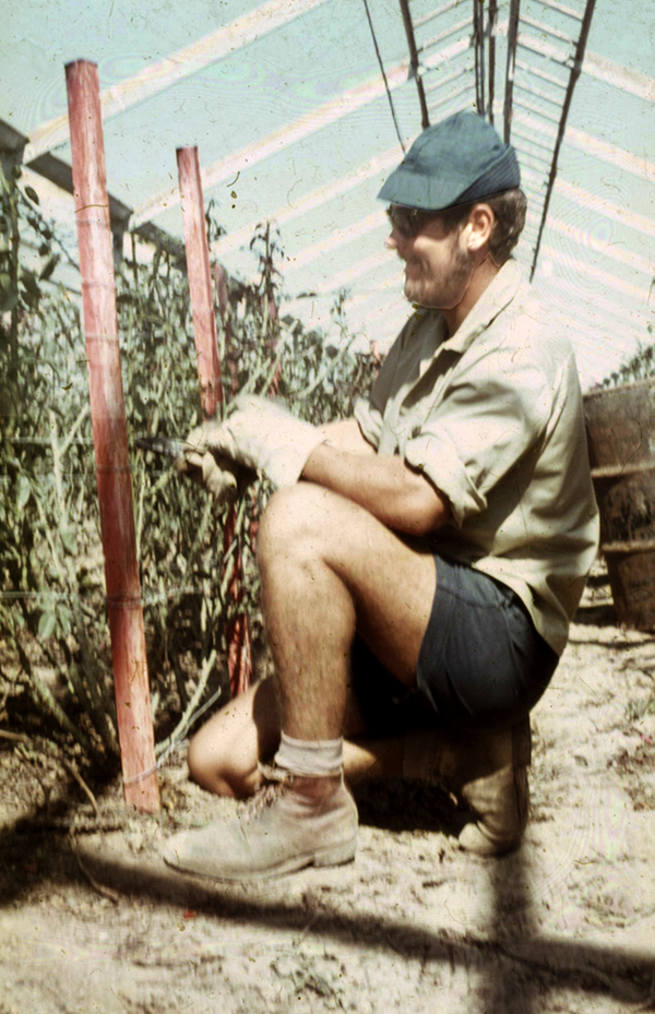
But back to the present. The Gaza Strip has been off bounds to Israelis since they evacuated the area in 2005. The situation was different when after the 1967 Six Day War, I worked as a volunteer in Kibbutz Yad Mordechai, which is near the northern border of the Gaza Strip.
Working in the greenhouses of Yad Mordechai where roses were grown for export to the Netherlands and Switzerland
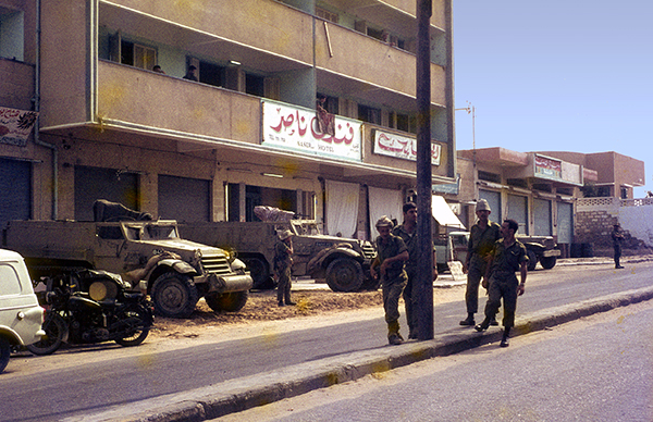
There were no border controls at that time, and it took me less than an hour to walk to the centre of Gaza. Soon afterward, however, the entire Gaza Strip became off-limits to civilians.
Israeli soldiers and two half-tracks in front of Nasir Hotel in Gaza. Photo: Leen Ritmeyer
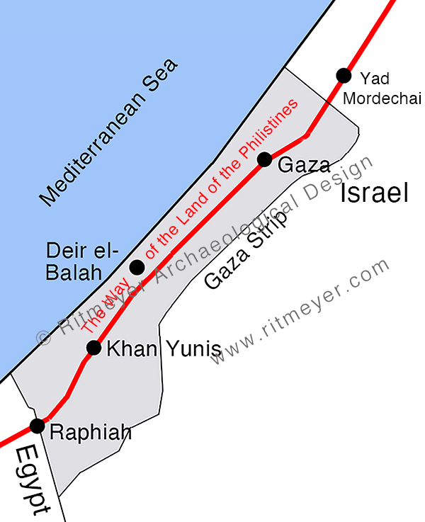
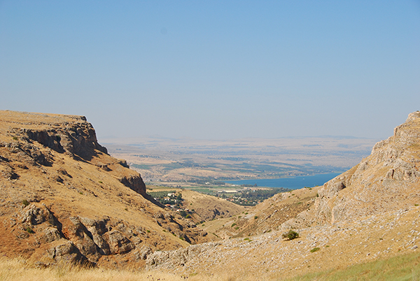
The Gaza Strip is rich in archaeological remains. The reason for this is that the great international coastal highway between Africa and Asia ran through this area. This great trunk road connected Egypt in the south with Syria and Mesopotamia in the north. It is one of the oldest roads in the world and is called the Way of Horus by the ancient Egyptians, and in the Bible, it is known as the Way of the Land of the Philistines (Ex. 13:17).
Numerous towns, fortresses and caravanserais were built along this road that runs a few miles inland due to the wide strip of sand dunes that lines the Mediterranean coast. Ancient armies, traders, caravans, and travellers moved along this road. Many biblical characters, such as Joseph, Jacob, and infant Jesus with Mary and Joseph, travelled along this road too.
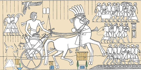
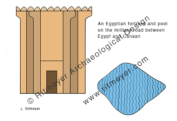
When the Israelites under leadership of Moses left Egypt, they were warned in Ex. 13:17 not to follow the “Way of the Land of the Philistines”, lest the people “change their minds when they see war and return to Egypt.” Archaeological discoveries have shown that they would have had to fight the Egyptian garrisons that were guarding this route. This road, known to the Egyptians as the “Way of Horus”, was the military road between Egypt and Land of Canaan as it was called then. Gaza was the capital of Canaan in the time of the New Kingdom in Egypt (1550–1077 BCE). This road appears in graphic form on the northern wall of the hypostyle hall at Karnak. It shows that strong fortifications were built along this road, a fact that has been verified by archaeological excavations. Prof. James Hoffmeier excavated the Migdol fortress in Egypt that was built at the beginning of this road, and I was involved in the excavations of one of the more northern fortresses, namely at Deir el-Balah in the Gaza Strip. This road was fortified by Seti I (1294-1279 BCE) and continued in use until the middle of the reign of Ramses II (1279-1213 BCE). The fact that the Israelites were told to avoid this road is a point in favour for the late date of the Exodus.
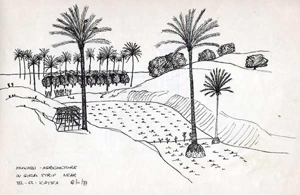
Places that we hear of in the news, such as Rafah (ancient Raphiah), Khan Yunis and Gaza are located on this ancient road. Ten years after my first visit to Gaza, I joined an archaeological tour and visited Gaza, Tel Katifa, Deir el-Balah, and Khan Yunis.
We were impressed by the muwassi hydroponic agriculture that we saw near Tel Katifa. The land in this area sits on an aquifer of sweet water. Bulldozers had been used to remove the sand dunes down to the original soil. As the sweet water floats to the surface above the heavier sea water, a fertile area was created where vegetables and other crops could be grown.
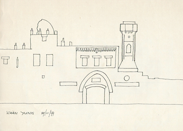
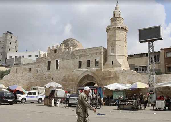
We then travelled south to Khan Yunis where I made a quick sketch of the Barquq caravanserai.
I was pleasantly surprised to see in a recent blog post by Brandon Marlon for the Times of Israel that the building still exists today.
The Barquq Caravanserai today
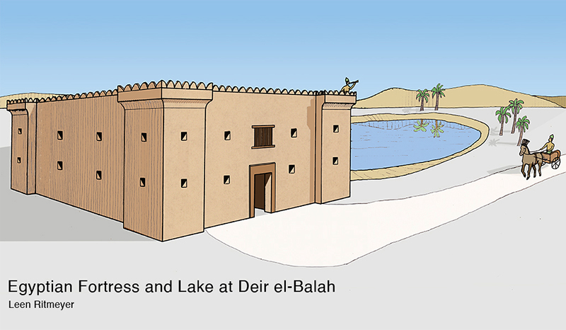
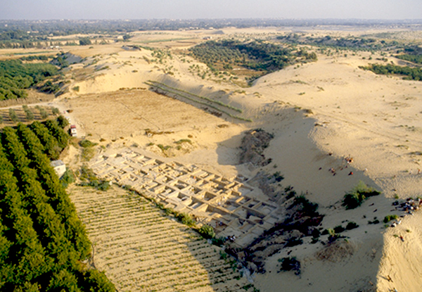
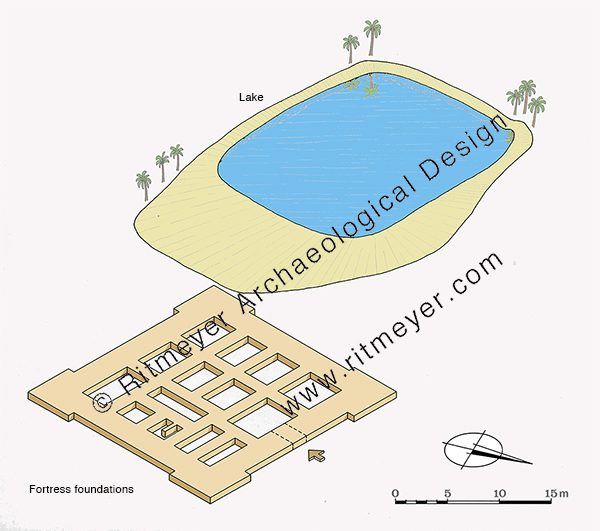
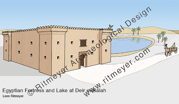
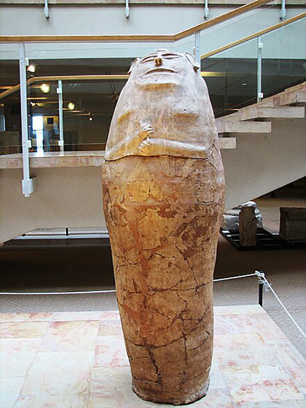
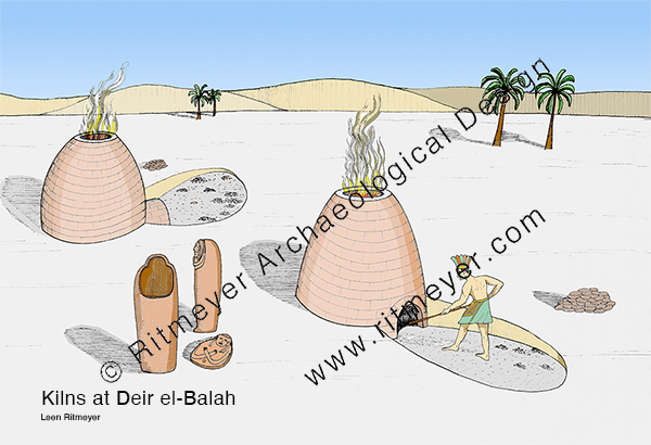
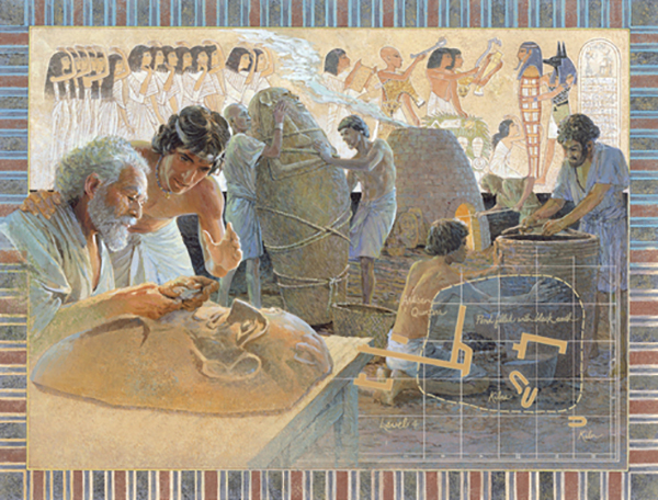
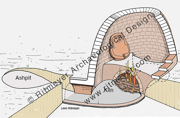
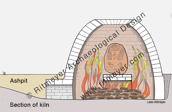
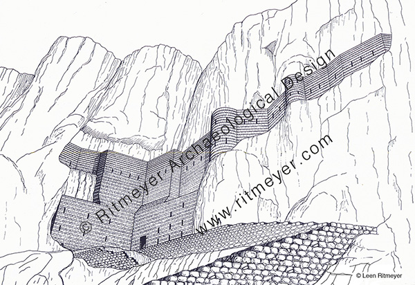
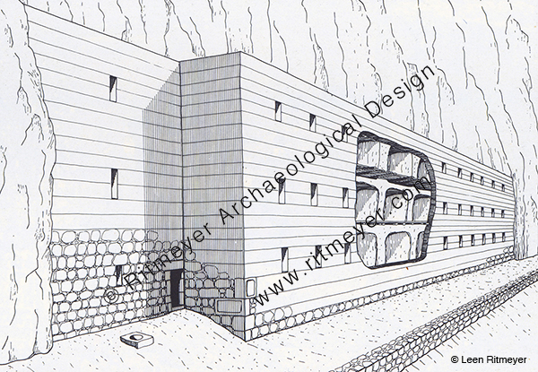
On our way back, we visited the excavations of Deir el-Balah. Prof. Trude Dothan of the Hebrew University carried out excavations of the site between 1972 and 1982. Remains of clay coffins were found and kilns in which anthropoid lids were fired. Additionally, the remains of a large fortress that measured 20m (66 feet) square were found and an adjacent lake or reservoir.
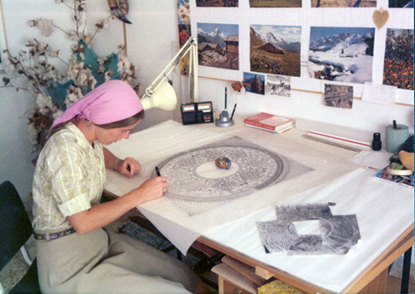
One year before the end of the excavations, in 1981, Trude asked me to make reconstruction drawings of the site for her final publication. These were later used by artist Lloyd Townsend of the National Geographic to illustrate Trude’s article “Gaza Sands Yield Lost Outpost of the Egyptian Empire” in the 1982 December issue. I recently digitised these drawings and colored them in.
In 1967, Trude Dothan saw many clay lids of anthropoid coffins that appeared in the antiquities shops in the Old City of Jerusalem. She noticed that fine grains of sand were embedded in the clay. This gave her the idea that they may have originated from the Gaza Strip or the Sinai desert. This was confirmed by Moshe Dayan who was defense minister at the time. Eventually she was allowed to conduct archaeological excavations at this site.
We hope that the present suffering will end soon, and that the “times of refreshing may come from the presence of the Lord, and that he may send the Christ appointed for you, Jesus, whom heaven must receive until the time for restoring all the things about which God spoke by the mouth of his holy prophets long ago.” (Acts 3:20,21).
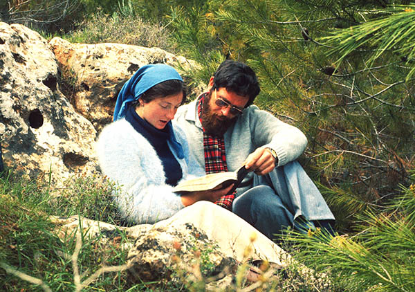
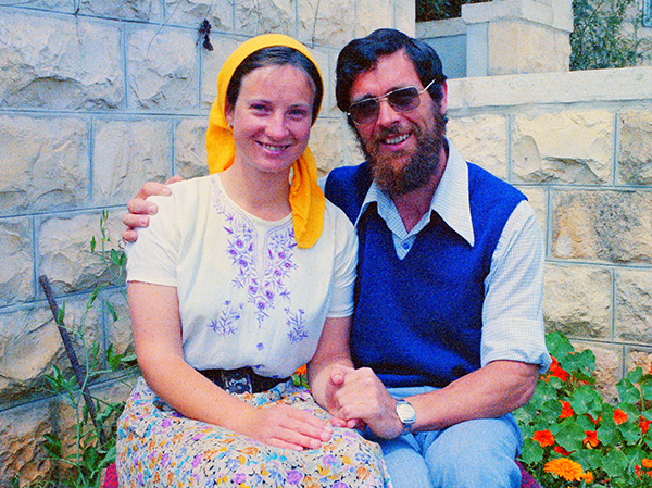
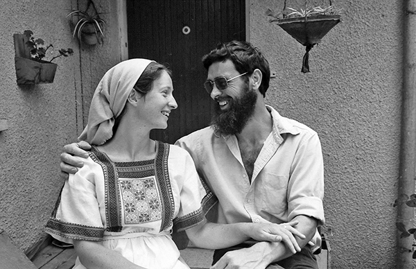
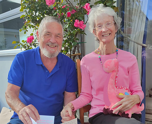
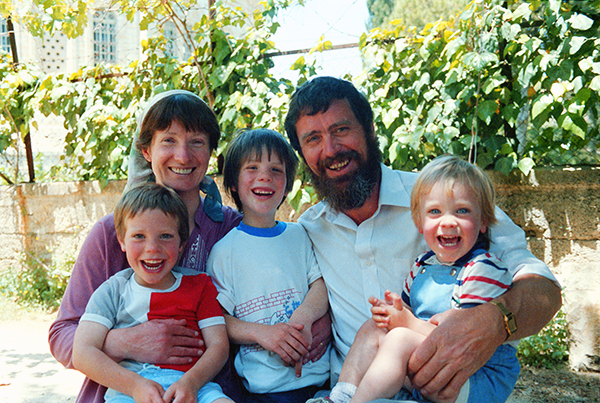
Today, the 1st of October 2023, Kathleen and I celebrate our 45th (sapphire) anniversary. We enjoyed many wonderful years of love, loyalty and dedication to each other, and shared interests in our faith, family, and archaeological work. We both love God’s Word, the Land of Israel and other biblical lands, and the Hebrew language. In many ways Kathleen (I call her Katia) is my equal and more, but she never wanted to attract attention to herself. All she ever wanted to do was to be my helpmeet. Katia was and always will be the “desire of my eyes”. Here is how it began.
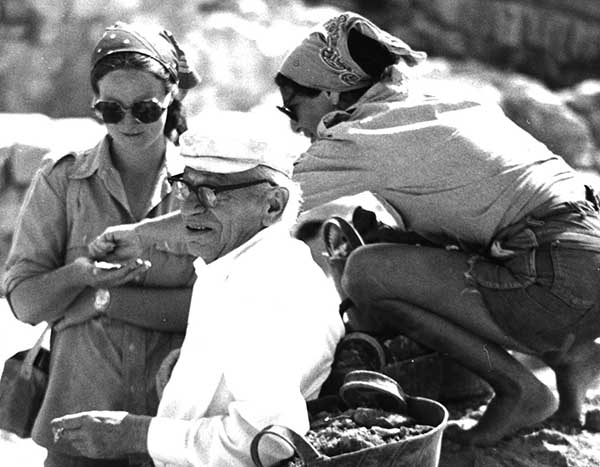
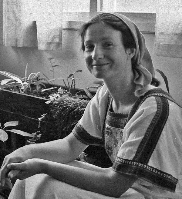
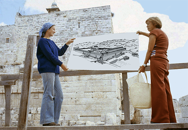
The 1st of October 1975 was exactly 48 years ago that Kathleen O’Mahony (BA Archaeology, University College Dublin, Ireland, PGCE) arrived at the southwest corner of the Temple Mount Excavations to join the introductory tour I was giving for new volunteers. Katia had come to work on the dig as archaeological supervisor and occasional surveyor.
Katia at left with Prof. Benjamin Mazar, director of the Temple Mount Excavations, in the foreground, and an American volunteer at right.
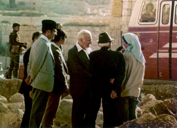
Drawing in Leon and Jill Uris’ book Jerusalem, Song of Songs, with Katia at left (coloured in).Meeting the then President of Israel, Ephraim Katzir. From right to left: Katia, Prof. Mazar, Ephraim Katzir.
Living in Jerusalem and seeing the variety of representatives of the different churches, she began wondering which of them was right. Katia also asked me what I believed, and so began many sessions of her asking questions and me answering from the Scriptures. We soon realised that our relationship was growing into something beyond teacher and student.
Reading the Song of Songs near Solomon’s Pools near Bethlehem.One thing led to another, and we fell madly in love, and still are. Exactly three years after we first met, we married on the 1st of October 1978.Just married in 1978. She loved her Druse dress.A very happy Katia with a lovely cheeky smile!45 years later.
We also celebrate 40 years of our Ritmeyer Archaeological Design (RAD) partnership. Katia is a professional archaeologist and excellent researcher, and her outstanding writing skills enabled us to co-author many books. We both love bringing the past to life, she with words and I with reconstruction drawings. We often reminisce about the many projects we have been involved with.
In the first year of our partnership, I joined the late Yizhar Hirschfeld in his search for Byzantine monasteries in the Judean Desert.
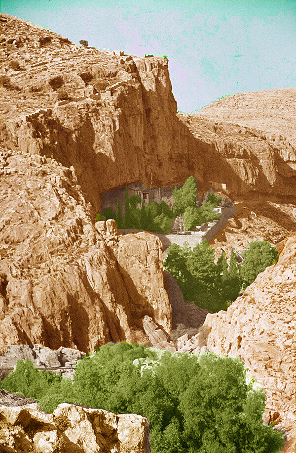
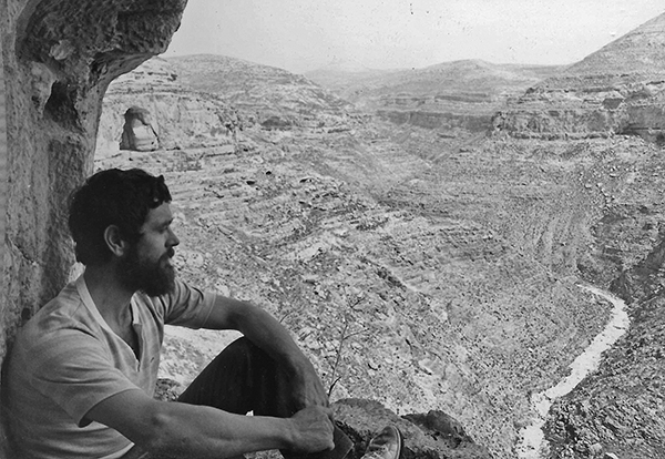
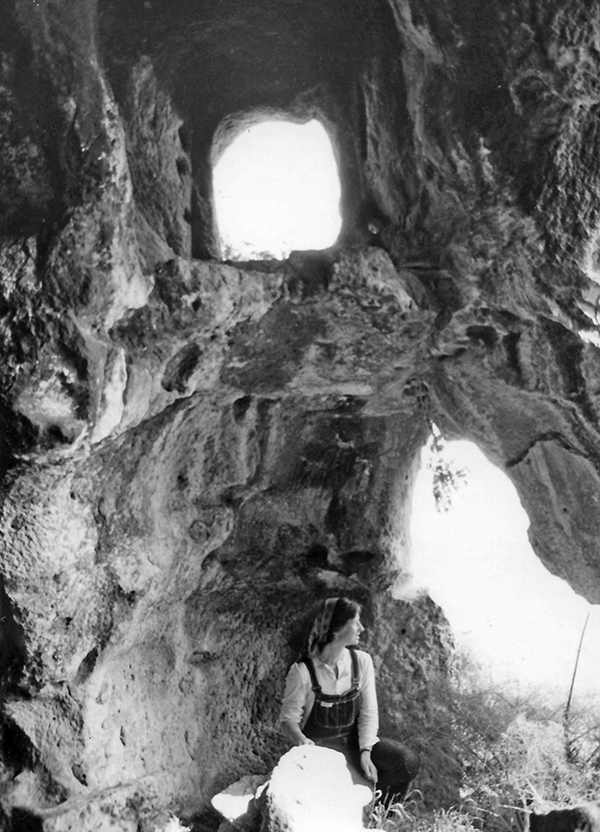
The Byzantine monastic movement in the Judean Desert was initiated in the 4th century AD by Chariton, who was born in Iconium (modern Konya, in Turkey). After the cessation of persecution of Christians, he made pilgrimage to Jerusalem, but was taken captive by bandits, who took him to a secret treasure cave in Pharan, near the spring of Ein Fara, not far from Anathoth (Arabic anata). Eventually he was rescued and inherited the cave and its contents and founded his first monastery there. I visited this monastery for the first time in 1970.
The Monastery of Pharan in 1970. It is located in the upper canyon section of Wadi Fara, near the spring of Ein Fara, about 6 miles (10km) northeast of Jerusalem, just beyond Anathoth. At that time, a monk called Alexander, at far right, was still living in this monastery. Soon after our visit he left for Vienna, and his monastery was unfortunately destroyed.
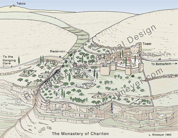
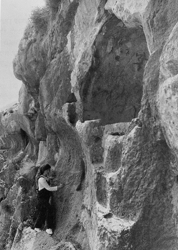
After leaving Pharan, Chariton established two other monasteries, the first one was the Laura of Douka, on the Mount of Temptation, and later the Monastery of Chariton – also called Souka, near Tekoa. The name of the monastery’s founder, Chariton, is preserved in the Arabic name of the site that is called Khirbet Khureitun and of the valley below, Nahal Khureitun. The modern name of the valley is Nahal Tekoa.
This laura monastery was established by Chariton above the steep cliffs of Mount Quruntul to the west of Jericho. The two cliffs descend to Nahal Khureitun, or Nahal Tekoa. The nucleus of the monastery is triangular in shape with a tower at each corner. As it was built on a steep slope, massive retaining walls had to be built along the base to create level areas for construction.
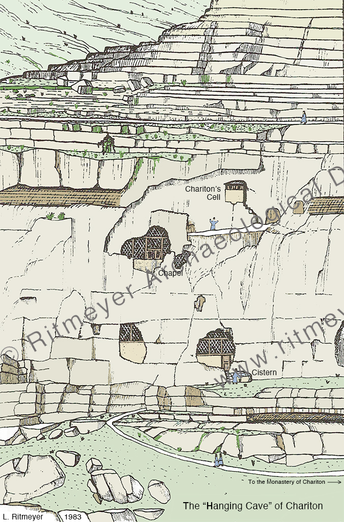
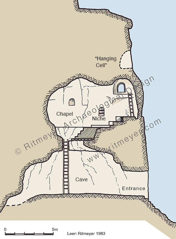
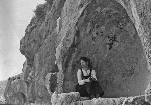
There are two types of monasteries, the laura (from the Greek word for path) is a community of monks who live in individual cells around the church and, walking over the paths that lead from their individual caves to the monastery, meet communally during the weekend. A coenobium (from the Greek koinos bios, meaning communal life) monastery is an enclosed complex where the monks live, work, pray and eat together. Chariton sought solitude in the last years of his life which he spent in the Hanging Cell of St. Chariton.
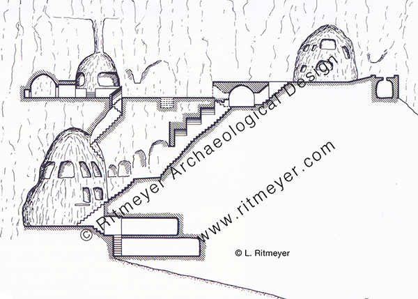
This reconstruction drawing shows the “Hanging Cave” complex on the southern bank of the Wadi Khureitun, which still bears the name of Chariton. The Cell of Chariton is located 15m (50 feet) above the entrance at ground level. Next to the entrance was a cistern. The cell could be reached by ladders via two lower caves. This section of the “Hanging Cave” monastic complex shows three different levels. The lower bell-shaped cave was reached from the valley by climbing some steps near the entrance. Using a 5m (15 feet) high ladder, the chapel on the middle floor was reached. From there, another ladder led to a small opening that led to the “Hanging Cell”.This drawing shows a monk climbing through a high opening in the chapel to a cliff-side channel that led to some steps by which the cell could be reached. Remains of fixings in the rock for a wooden door at the entrance to the cell, and the low remains of a stone wall facing the valley, indicate that the cell was protected from the elements.
We have fond memories of this Cave Church of St. Chariton in the stunningly beautiful Wadi Khureitun in the heart of the Judean Desert near the settlement of Tekoa.
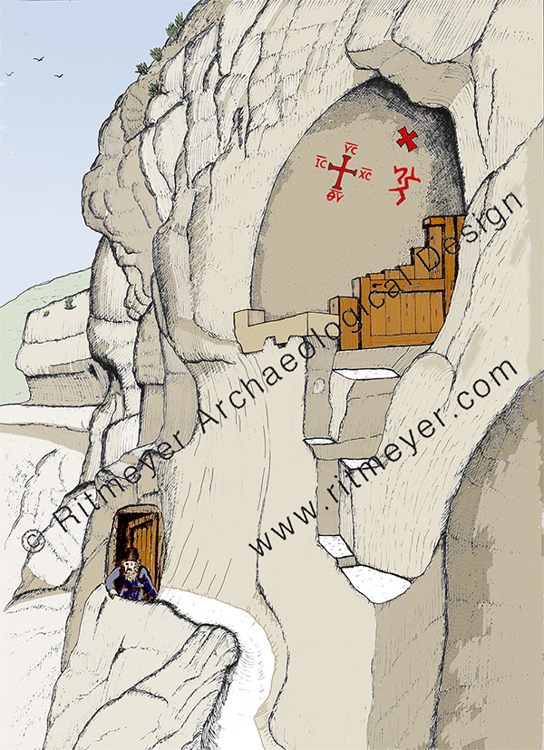
Leen in the Cell of Chariton on an earlier visit.
I had been there already with Yizhar, but I wanted to show Katia this amazing site and take further measurements to help illustrate his book The Judean Desert Monasteries in the Byzantine Period, Yale University press, New York, 1992, for which Katia did a lot of translation work. This is what she wrote about that memorable visit:
“Access to the Cell of St. Chariton was via an iron ladder of 5m in length bolted into the sides of a rocky mountain – quite an adventure! Here you overlook the ravine that at the time we visited was full of wild tulips. There were pine and eucalyptus trees in abundance with natural springs gushing through the cracks in the rock supplying the area with sparkling waters. Standing in the small space with its uneven walls and ceilings covered with soot, we saw how the cave was connected by low passageways to other caves. In these, monks ate, slept and prayed in the “laura” (hermit settlement), established by Chariton. He had originally come on a pilgrimage from Iconium and been abducted by robbers before settling in the Holy Land to establish monasteries.”
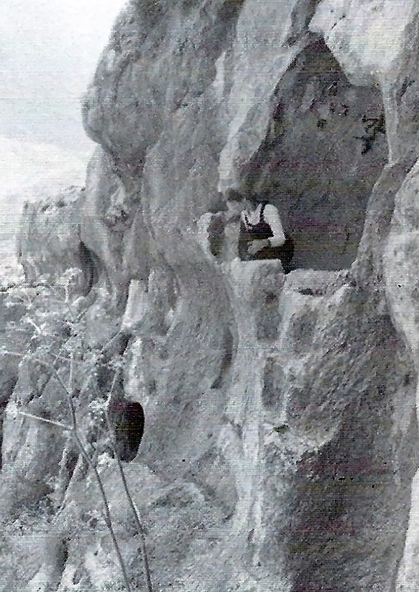
Katia in the chapel, waiting for a ladder to reach the opening above.Walking gingerly to the Cell of Chariton.Katia sitting inside the Cell of Chariton.Looking down at the 15m (50 feet) deep valley floor.
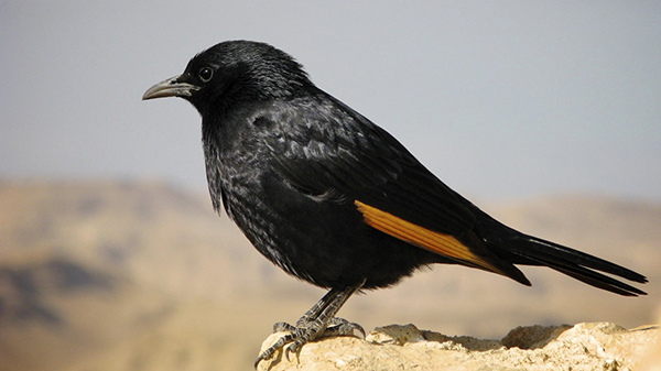
“The sight of the birds known as Tristram’s Grackle (with their iridescent black plumage and orange patches on their outer wing, and which are particularly noticeable in flight) diving down from the heights of the cliffs and sweeping upward just before they reach the bottom of the ravine, was incredibly beautiful.”
Tristram’s Grackle. Source: Wikipedia.
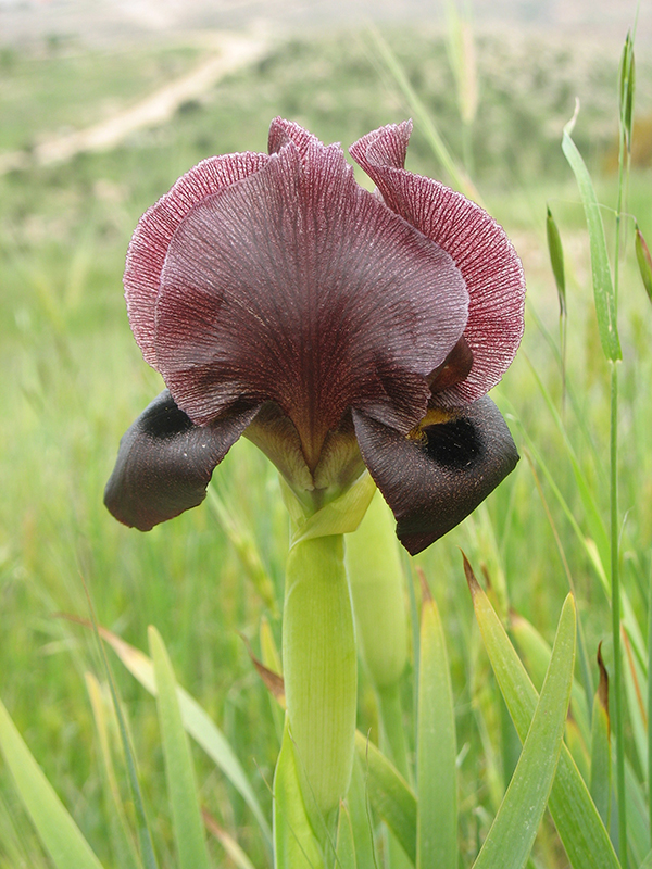
“The sight of some black desert irises that flower only occasionally in the desert, after a particularly wet winter, near Tekoa, was also very memorable.”
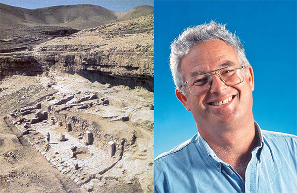
Black iris. Source: Wikipedia, shlomotm.Yizhar Hirschfeld and the monastery of Khirbet ed-Deir.
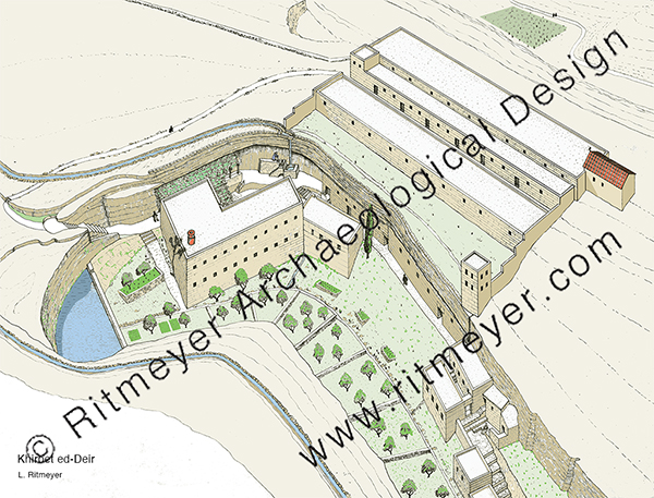
“That same year, we also made a wonderful family trip to Khirbet ed-Deir. Yizhar described it as “one of the most isolated and remote monastic sites of the Judean Desert … the location of the site in the heart of the desert and the excellent preservation of its remains leave a deep impression on the visitor.” It was located in the central part of the dry upper reaches of Nahal Arugot, about ten miles south of Bethlehem.”
The Monastery of Khirbet ed-Deir is located in a small ravine that branches off from Nahal Arugot, about 13km (8 miles) southeast of Tekoa, 16 km (10 miles) south of Bethlehem, and 27km (17 miles) south of Jerusalem.
“The monastery’s remains are built on a spur that rises above the riverbed’s south bank and along a gorge on the south side of the spur. Natural caves were incorporated into the monastery. It was basically a “cliff-side coenobium” where monks lived together as a commune.”
The Cave Church of Khirbet ed-Deir was built inside a large cave that was part of the monastery.
“While Leen was busy surveying the different parts of the monastery, we had been exploring the gorge and were getting out some drawing materials so that our children could record the visit.”
Our young family in Jerusalem.
“Suddenly, a group of Bedouin children appeared out of nowhere, wanting some of the equipment. I gave them some of our novelty pencils and rubbers and chatted with them, telling them what Leen and Yizhar were doing. They were amazed that we were bothering with a small site in the desert, but very pleased with their little gifts.”
“Yizhar was busy bringing out his book on the monasteries in the Judean Desert and we learnt a lot about them through his work. He lent us a book called The Desert a City: an introduction to the Study of Egyptian and Palestinian monasticism under the Christian Empire, by Derwas James Chitty (London, 1966), which, one writer said, was ‘full of brilliant passing insights and wonderful throwaway lines’ about the “City of the Wilderness.”
During our 22 years of work and exploring the Land we visited many memorable sites. Visiting these Byzantine monasteries in the Judean Desert, however, was a major highlight.
In our previous blog, we looked at the Middle Gate as an example of the description in Lamentations 2:9 that Jerusalem’s “gates were sunk into the ground.” We published it on the 1st of September, as that was one of the readings for the day according to the Traditional Daily Reading plan of the Avery Bible app.
Today, on the 5th of September, according to this plan, we begin reading the Prophecy of Ezekiel. From Chapter 1 we understand that Jehoachin, King of Judah, was exiled to Babylon along with Ezekiel and several thousands of Jerusalem’s leading citizens.
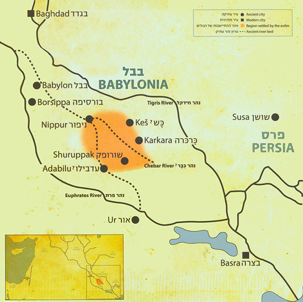
According to Ezra 2:59, the Jews lived in villages like Tel Abib, Tel Melah, Tel Harsha, Cherub, Addan, Immer and Casiphia, from where they returned following the Edict of Cyrus in 539 BC. The location of these places is not known, but it is understood that these were clustered round the River Chebar, where the Jews were forced to work on government projects.
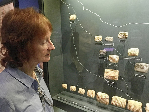
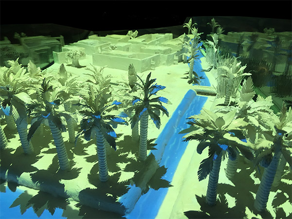
A few years ago, in 2017, as part of an archaeological project we were doing in the area, we visited the Bible Lands Museum in Jerusalem. At that time, the curators had put on a dazzling display called “Jerusalem in Babylon”, showing archaeological evidence for some of the places where the exiles lived. This was the first time that archaeology had proved that Jews lived here during the Exile. The following images are photographs taken by permission of the Bible Lands Museum.
The orange tinted area indicates where the exiles were settled.
While reminiscing recently about the highlights of our archaeological careers, we could not help but include our visit to this exhibition as a stand-out experience.
We had assumed that this was only a temporary exhibition and expected it to be dismantled. We were pleasantly surprised, however, to see on their website that this exhibition is still very much on!
An animated movie in Hebrew (but with English subtitles) introduces the story of the Exile for children. We were indeed relieved to see that this unforgettable exhibition could still be enjoyed by the next generation.
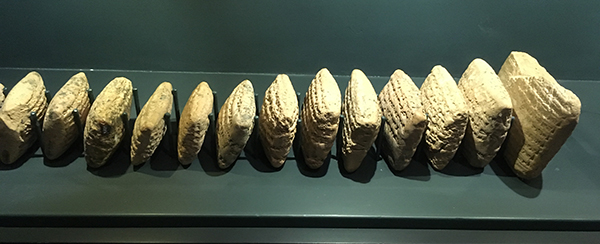
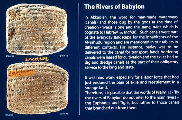
These are some of the inscribed clay tablets that mention the places where the exiles lived. Kathleen examining a vitrine in which several clay tablets are displayed.
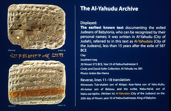
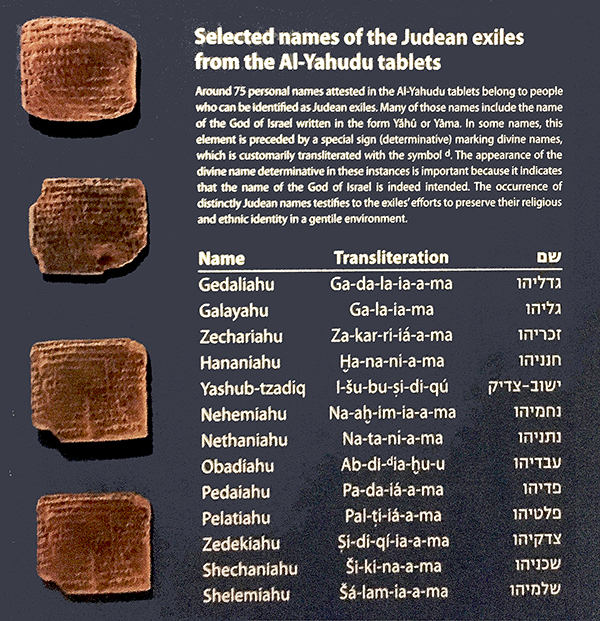
The text on some of the clay tablets that were discovered showed that the exiles lived in an area called Al-Yahuda (City of Judah) or Al-Yahudaiah (City of the Judeans), where they were initially forced to dig and dredge canals for transportation of goods as part of their obligatory service to the king and state.
Some clearly recognisable Jewish names, such as Gedaliah, Zechariah, Hananiah, Nethanyahu, Obadiah and Zedekiah, have been found on several of these tablets.
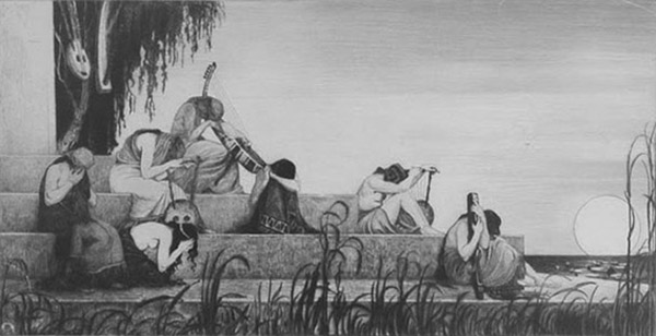
“On the Rivers of Babylon” (1910), by Ephraim Moshe (Moses) Lilien, an Austro-Hungarian art nouveau illustrator and a member of the Zionist movement. The people on this etching are mourning next to a large river.
The Akkadian word for man-made canals (naru, Hebrew nahar) is one and the same for rivers. Therefore, it is possible that the words in Psalm 137:1, “By the rivers of Babylon there we sat down, yea we wept when we remembered Zion”, do not refer to the main rivers, the Euphrates and Tigris, but rather to those canals that branched out from them, which the Jewish captives were forced to dig. It was hard work, especially for a labour force that had just survived the destruction of their country and a long march from Judah to Babylon. These canals were needed to bring water for irrigation purposes and for bringing goods to inland cities, such as Babylon.
When that work was completed, the Jews were allowed to settle in the land.
This illuminated model gives an impression of the houses in which the exiles lived, next to a hand-dug canal. This tablet contains evidence for the man-made canals that the exiles were forced to dig.
The text on these tablets also showed that after an initial hard time, the Jews quickly settled down and became prosperous. Some preferred to stay in Babylon rather than to endure the hardship of pioneering work in the province of Judea.
However, after 70 years, many exiles that had been living in Babylon since the conquest of Judah by Nebuchadnezzar, returned from Babylon to Jerusalem and Judea.
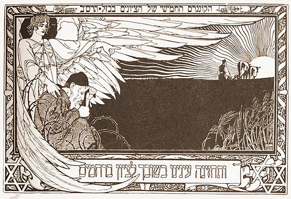
At the end of the 19th century, Jews again, after a much longer exile, returned to the Land of Israel, and many saw a historical parallel with the return of the exiles from Babylon.
This engraving by Ephraim Moses Lilien was printed on the invitation for the 5th Zionist Congress, held in 1901, as stated in Hebrew at the top of the drawing. The pogroms in Russia and Eastern Europe at that time stimulated Jewish immigration to Palestine. This ideal has profound religious and historical roots, one of which was the return to Zion after the Babylonian exile.
The lower Hebrew inscription reads: “May our eyes behold your return in mercy to Zion.”
“her gates have sunk into the ground.” (Lamentations 2:9)
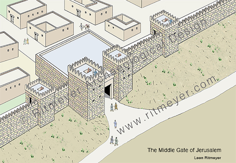
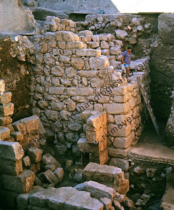
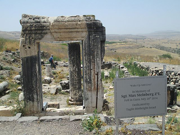
The Middle Gate is mentioned in Jeremiah 39.3 as the place where the Babylonian princes came together to celebrate their conquest of Jerusalem. The destruction of Jerusalem was dramatically exposed in the excavations in the Jewish Quarter of the Old City of Jerusalem that were directed by the late Prof. Nahman Avigad. After digging down for some 10 m., a large L-shaped fortified wall of the Israelite period was found.
Here we see the corner of a large L-shaped fortified gate that was excavated in the Jewish Quarter of the Old City of Jerusalem.
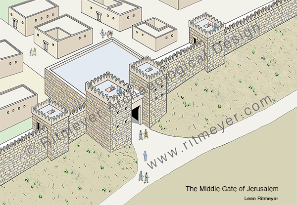
This gate was called the Middle Gate as it was built in the middle of the northern wall of Jerusalem of that time. It is amazing to think that the Babylonian princes, who sat in the Middle Gate, Nergal-Sharezer, Samgar-Nebo, Sar-Sechim, Rab-Saris, Nergal-Sharezer and Rab-Mag, all came from what is now known as Iraq.
A partial reconstruction of the excavated remains of the Middle Gate.
Jeremiah witnessed and lamented the Babylonian destruction of Jerusalem in 586 BC. “O wall of the daughter of Zion, let tears run down like a river day and night; give yourself no relief; give your eyes no rest” (Lamentations 2:18).
In Lamentations 2:9, we read that “her gates have sunk into the ground.” As all large buildings in Jerusalem, including the gates, were built on the bedrock, these gates could not have sunk deeper into the bedrock on which they were built.
However, there is a logical explanation for this description. The Today’s English Version (formerly the Good News Bible) paraphrases this verse as, “the gates are buried in rubble”. After the destruction, rubble and destruction debris would have accumulated around the destroyed gate and raised the ground level around it, so that the preserved top would have been barely visible. This would have given the impression that the gates had sunk into the ground.
It is exciting to find the remains of buildings that are mentioned in the Hebrew Bible, but also sad to reflect on the terrible destruction that took place some two and a half thousand years ago.
Fifty years ago today, I embarked on a career which previously I hadn’t know existed and couldn’t have dreamed up for myself. It combined the disciplines of archaeology, ancient architecture, history, education, and Biblical Studies. Since realising, a few years later, that this would require the wearing of multiple hats, (although my fedora was the one that was most practical and the one that became identified with me), I got used to various titles like: “Archaeological Architect”,“Conservator” and “Lecturer”. However, I soon learnt that the hat of Bible Student was the most valuable, and that which could encompass most of my interests. My studies of the Bible had taught me core skills that could be useful in many situations. Research, analysis, interpretation, and application, to mention but a few, all could be improved and enhanced by immersion in the Good Book.
A few months ago, one of my sons, Ben, was looking at a book that contained drawings of cities from Biblical times with one of his sons, Seth ( my now 5-year-old grandson). Ben mentioned that some of these sites were thousands of years old. Seth exclaimed: “as old as Grandad!” Now, I do not claim to be thousands of years old.
Grandson Seth at my computer desk
But when I looked around my workroom/studio in the cottage we now live in South Wales, I realised that within its walls lie physical evidence of 50 years of visualising the Bible. Its main holding is a substantial library of volumes that contains many of my reconstruction drawings. Some of the most well-known are Study Bibles and our own books, most of which have been published by Carta of Jerusalem. There are traditional dig reports and guide books too. And, added later, also items of a more unusual shape, like CDs and DVDs.
So – if this turning of the year makes you feel like hearing the story of Ritmeyer Archaeological Design, gather round and I will try my best to tell it. And for those of you who on occasion have asked: “How can we learn to do what you do?”, you may pick up some hints or feel that you have had your fill already.
A Dutchman, I graduated in 1967 with a degree in Physical Education from Arnhem. At that time there was compulsory military service, and within a week all my friends had been enlisted, but I was the only one not called up. As I could not commit myself to at least one year of teaching, I decided to go and travel until the military call-up arrived.
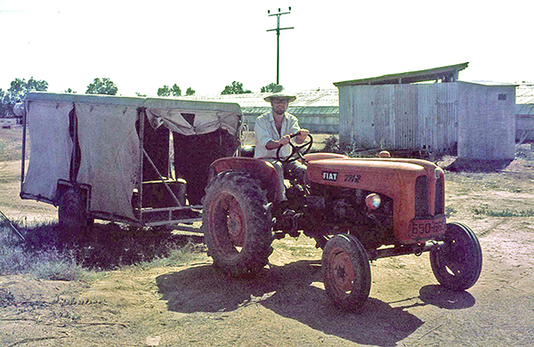
After the Six-Day War, there was a shortage of manpower in Israel, as most men were still mobilised. So, I volunteered in Kibbutz Yad Mordechai near the Gaza Strip and stayed there for almost half a year. I used my free time to travel through the Land, began to read the Bible and learnt Biblical Hebrew. The combination of knowing the geography of the Land and learning Hebrew greatly increased my understanding of the Scriptures and developed in me a love for the Land that only got stronger over time and never left me.
Driving a tractor at Kibbutz Yad Mordechai
In 1969, I decided to try and settle in Israel, which as a non-Jew was not easy, but I eventually found work on the Temple Mount Excavations under the direction of the late Prof. Benjamin Mazar (1906-1995). Before finding this position, I had written a letter to David Ben-Gurion, the former Prime Minister of Israel and was granted permission to stay as a temporary resident. I held this status in fact, for twenty years – a permanent temporary resident!
And reflecting on the way I had originally found the job on the Temple Mount Excavations, it also seemed pretty fortuitous. In 1972, I had read a report about the Temple Mount Excavations in which they appealed for more staff. My late sister Martha had got a job illustrating ancient architectural elements when she applied. She did very well at this work, which she liked very much. We decided to move from the area of Petach Tiqva (Door of Hope), the area where we had been living and earning a livelihood, and we found a house in Bethany near Jerusalem.
My late sister Martha drawing one of the domes in the Double Gate passageway
After hearing from Martha that I was also looking for work, the deputy director of the dig, Meir Ben-Dov, asked me to come and work there too. I was not too enamoured when I saw the dig with its broken stones and walls and volunteers slaving away in the dust and heat. He offered me the job of drawing potsherds in a tiny room that was a converted cupboard. I ran away as fast as I could! However, he persisted and eventually offered me the job of surveyor. I had never done anything like that but replied that I knew where the zero on the tape measure was and was ready to give it a go.
Surveying an ancient wall
So, on the 1st of January 1973 I started to work as the dig’s surveyor, making plans on a scale of 1:50. An Irish architect, Brian Lalor, later to achieve renown in his own country in the field of printmaking, trained me in and I liked the work. When I showed him my drawings, I observed what he did with them. He reduced my plans and then completed broken or missing walls and reconstructed elevations and then made complete reconstruction drawings of the building remains that I had surveyed. I thought this was fantastic and, seeing that I was interested, Brian gave me a Byzantine bath house to reconstruct, a work that quickly drew me in.
The great joy in archaeological excavations is figuring out how architectural structures worked. A couple of months later I was asked to survey the Herodian shops to the east of the Triple Gate. These shops were at a much lower level than the street in front of this gate. It was obvious to me that the roof of these shops must have supported the street above. I asked Brian what kind of roofs they might have been, but the response was unclear. One morning, when the sun was shining at just the right angle, I looked up and saw the burnt imprints of arches in the Southern Wall of the Temple Mount and figured out that the descending stepped street above must have been built over the vaulted ceilings of these shops. The shops had been burnt down by the Romans in 70AD, but before the vaults collapsed, the fire burnt into the Temple Mount wall, leaving the imprints of the vaults as an evocative testimony to this dreadful inferno!
The burnt imprint of the vault closest to the Triple Gate
My theory at first was greeted with unbelief, but when Prof. Mazar and Brian came to have a look, they were bowled over when they saw the actual evidence. The difference in height between these vaults was 60 cm (2 feet). This corresponded to the height of three steps. And so, it was possible to make a watertight reconstruction of the street above the shops. The excitement and thrill of this discovery got me hooked on ancient architecture for life.
The difference in height between the burnt arches corresponded to three Herodian steps.
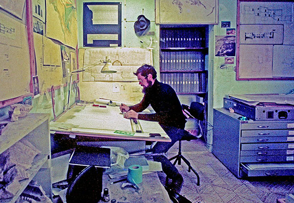
Four months later, Brian left to return to Ireland, and Benjamin Mazar told me to sit in the architect’s chair and to continue supervising a small team of volunteer surveyors that I had trained in. I was left in charge of the architect’s office, and that is how my career as an archaeological architect took off. During the winter months of 1973, Mazar sent me to the library of the Rockefeller Museum to study ancient architecture under his personal guidance.
In the architect’s office
The making of reconstruction drawings, that became my speciality, was born out of necessity. Apart from my regular architectural work, some staff members including myself, gave tours to other archaeologists and visitors. It was this experience that convinced me of the necessity for these drawings. One of the first stops on the tour was Robinson’s Arch, one of the four gates in the Western Wall of the Herodian Temple Mount. I tried to explain the features of the arched staircase that led up to the Temple Mount from the street below, sometimes using my hands and feet. From questions I received afterward, I realized that not everybody could visualize how it worked. I then made my first reconstruction drawing of Robinson’s Arch. On this drawing, I indicated in color the visible remains and drew the reconstruction in black and white lines. This visual connection with the archaeological remains made the reconstruction immediately recognizable. Seeing people’s faces change from incomprehension to clear understanding assured me that this was the way to go.
Reconstruction drawing of Robinson’s Arch
Eventually, my reconstruction drawing of the Temple Mount that was used by many guides, became a classic and has been published in many books.
During the Yom Kippur war in October 1973, Israel captured large areas of Syria from Kuneitra to halfway down to Damascus. This area was referred to as the Bashan. After the fighting was over, the soldiers who were archaeologists went back to their normal Unit for the Knowledge of the Country. They had to do an archaeological survey of the Bashan and found two-story Roman houses that had recently been lived in still standing up.
As the archaeologists couldn’t make architectural plans, I was employed by the Israel Defence Forces (IDF) to join this unit. This was very exciting, as this was my first visit to Syria and I got to know all the up-and-coming young archaeologists, such as Amihai Mazar, Dan Urman, Zvi Ilan and Amos Kloner.
A Roman house at Kafr Nasj in the Bashan
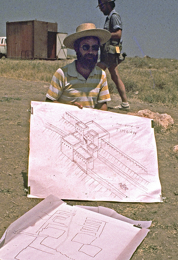
Later, some of this group asked me to make drawings for them. Amihai employed me to draw up the plans of the Tel Qasile excavations and later asked me to join the Tel Batash (Timnah of the Philistines) dig, Dan Urman asked me to join the Tel Nitzana excavations and draw up the plans of Rafid on the Golan, Zvi Ilan asked me to make a reconstruction drawing of the Byzantine Synagogue that he had excavated in Meroth, and for Amos Kloner I drew up some of the caves of Bet Guvrin.
Reconstruction drawing of the Gate of Timnah
Back at the Temple Mount excavations, I finalised the survey plans, and made reconstruction and publication drawings of buildings belonging to different periods. Prof. Benjamin Mazar was interested in the Herodian and earlier periods, while Meir Ben Dov was given responsibility for the later periods. From my office room I could see who was coming down the steps to see me. When Mazar came down, I quickly put the Herodian drawings on my desk and exchanged them for later period drawings when Ben Dov was visiting!
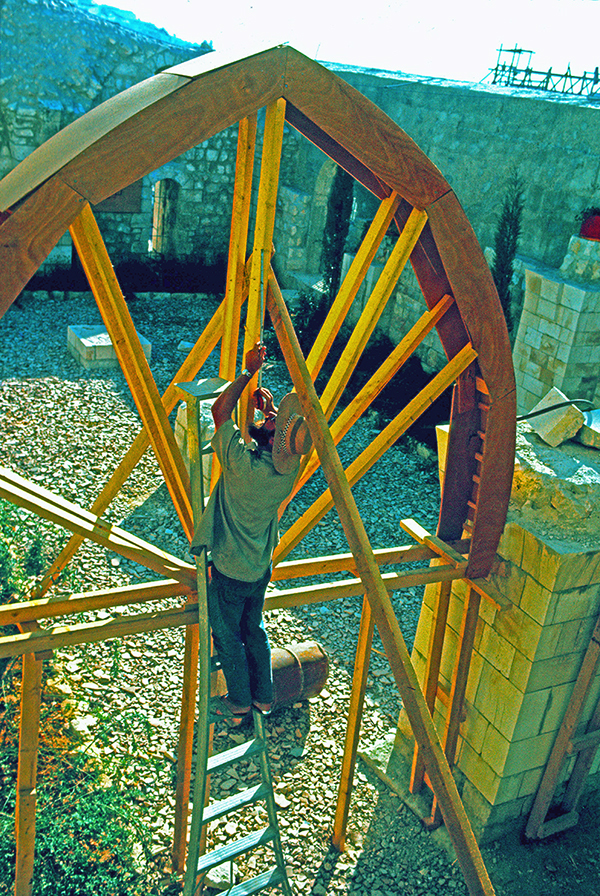
Another chapter in my career opened when I was asked to reconstruct the Crusader Church of Saint Mary of the Germans in Jerusalem. This work involved the building of a staircase and the pillars that once supported the vaults of the hospital hall of the hospice complex in the Jewish Quarter of the Old City. To make the pointed arches, I cut templates out of carton for the individual arch stones on the flat roof of our house in Melchizedek Street and gave those to masons in Bethlehem who cut the stones and built the arches.
Inspecting the wooden centering – a temporary frame to support an arch or vault during construction
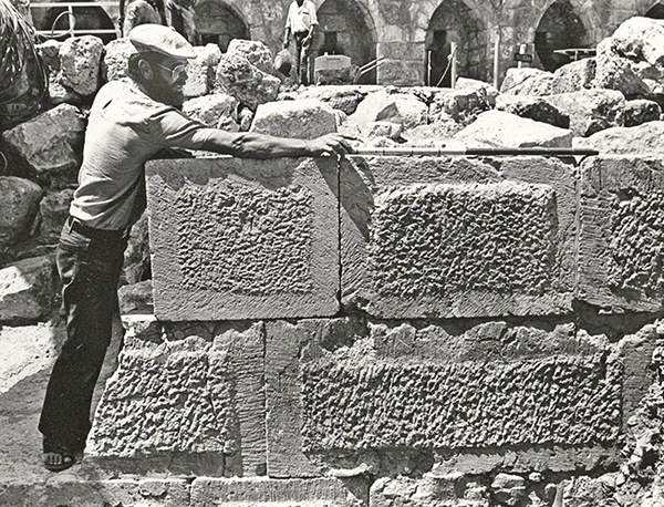
It was the first of several restoration projects I later became involved in, eg the Byzantine Cardo and the Herodian villas in the Jewish Quarter of the Old City of Jerusalem. Restoration consists of consolidating the actual remains to prevent deterioration. At times, it is important to reconstruct parts of the ancient ruins. This is extremely sensitive work. It is very important not to build up the site too much, but to do it so that one gets a real feeling for how it would have looked originally.
My life changed in 1975, when Kathleen, an Irish archaeologist, came to work on the Temple Mount Excavations. I still remember her joining the tour I was giving on the dig at the southwest corner, but had no idea that eventually she was to become my beloved wife. She was certainly the best find ever!
Kathleen at left using my Temple Mount reconstruction drawing during a guided tour
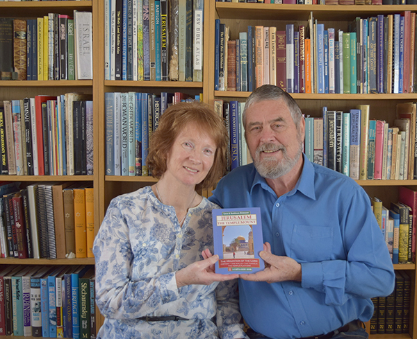
In 1983, Kathleen and I established a partnership called Ritmeyer Archaeological Design (RAD), which is an independent partnership devoted to archaeological reconstruction and the production of educational materials, and it is still active today. Kathleen’s excellent writing and research skills enabled us to produce books and varied educational materials that people still find useful today. Just as much as I like drawing lines on paper, she says that she loves to “push words around the page!” Working together has been a great blessing, as we have similar interests and complement each other.
Much of my time in Israel then involved the restoration, first of the Byzantine Cardo and the Herodian Quarter in the Jewish Quarter of the Old City, later called the Wohl Museum.
Checking the position of a capital during the restoration of the Byzantine Cardo.Drawing the design of the stucco decoration in the Reception Room of the Palace of Annas the High Priest.
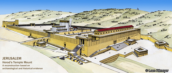
In 1989 we moved to England, and even though we no longer had a Jerusalem address, the projects kept coming in. One of the largest such projects was the design of models of the Tabernacle, Solomon’s Temple, and Herod’s Temple and Temple Mount for a Jewish philanthropist in Washington, DC. Photographs of these models, beautifully crafted by York Model Making, are included in RAD’s Image Library.
Model of Herod’s Temple Mount
Other projects I’ve worked on in recent years, include mapping every journey in the Bible and illustrating as many as these mappable events as possible for the United Bible Societies’ Augmented Reality Bible. And even more recently, I’ve collaborated on a voice-driven VR experience, in which a VR headset allows one to walk through a city or large building in a specific period. The first project we worked on focused on Capernaum. I provided all the archaeological and historical background, whereas other artists made the relevant 3D-enabled drawings and computer experts developed the technology.
Our Temple Mount guide book was published in 2016
My work has also brought many rewards for our family life. When our children were young, I was often able to take them on digs and give them memorable experiences that they still talk about today. When they were older, they helped me at times with photography, cartography, and illustration.
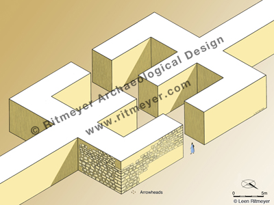
If you were to ask me what were some of the most exciting moments in my career, I would say they would be the making of major discoveries, such as the location of the Holy of Holies of Solomon’s Temple and the emplacement of the Ark of the Covenant, and the identification of the Middle Gate mentioned in Jeremiah 39:3. The latter made it possible to relive, as it were, the destruction of Jerusalem by the Babylonians. Arrowheads found among the charred timber and ashes at the base of the tower point to a fierce battle around the city walls of Jerusalem in the time of Zedekiah. Our hands got black with soot—tragic evidence of the fall of Jerusalem.
And for those brave ‘wannabes’ who would like to follow my footsteps, all I would say is: listen to your heart, find an encouraging mentor, and watch how he/she does things on a site you love in the Land. Make yourself as indispensable as possible and make reading the Word in the ruins your inspiration.
In our previous post we reported on the Arbel Fortresses and mentioned that we would describe the Arbel Synagogue in the next post.
Communal worship began in the Tabernacle and continued in the subsequent temples of Jerusalem. Synagogues emerged much later in time. Worship in synagogues was very different from that in the Temple. In the latter, cultic practice was led by a small group of priests and other officials, with the ordinary worshipers relegated to outer courtyards. In synagogues, leadership was open to all. Prayer and study replaced sacrifice, and ceremonies could be observed by everybody.
The first synagogues that were built in the Land in the 1st century, e.g. Gamla, Capernaum and Magdala, were flat-roofed and had benches built around the colonnaded interior. Later Byzantine synagogues had pitched, tiled roofs and were more elaborately decorated.
Synagogues were religious, cultural, and social centres of the Jewish community. Communal prayers and the study of the Hebrew scriptures were conducted for young students and adults, often in rooms set aside for that purpose. Whereas the main part of the synagogue, the assembly room, functioned as a meeting place with the emphasis on the Shabbat service, sacred meals were also served there, and communal law courts sat there.
The most important part of the Shabbat service was the reading of the Torah and its exposition, as noted by the author of Acts 15:21:
“For from ancient generations Moses has had in every city those who proclaim him, for he is read every Sabbath in the synagogues.”
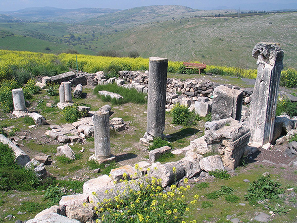
In the fourth century, a Byzantine style synagogue was built in the centre of the settlement of Arbel, on the west side of the middle residential terrace. In 1987-’88, Zvi Ilan and Avraham Izdarechet began preservation and restoration work on the synagogue and its surroundings, and they asked me to prepare a reconstruction drawing.
Remains of the synagogue. The fertile Arbel Valley is visible beyond the synagogue.Wikipedia.
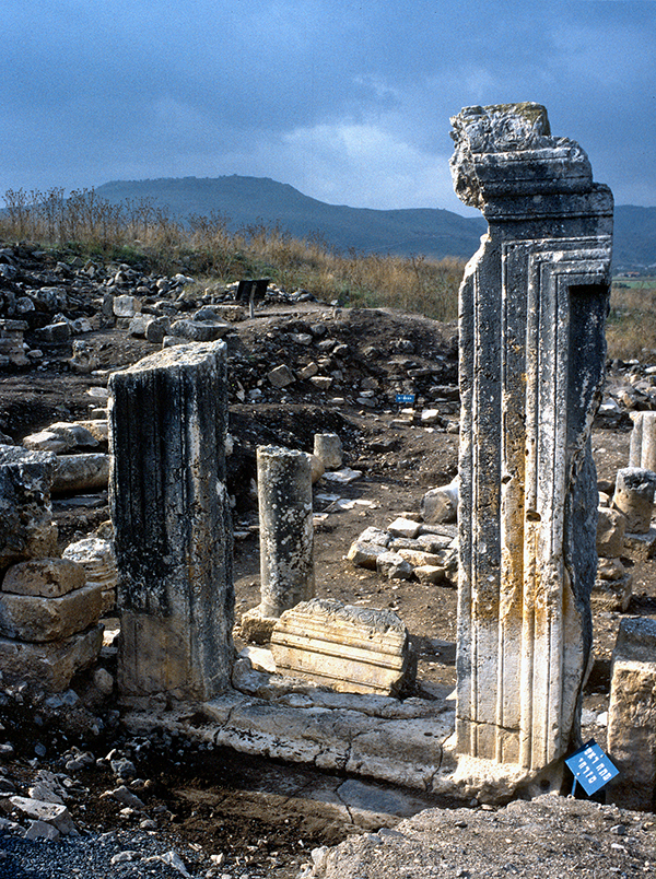
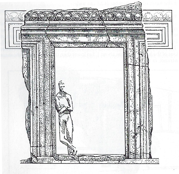
Its plan recalls other Byzantine synagogues in Galilee such as Capernaum, Chorazin, Tiberias, Meroth and others. Originally, the main entrance was in the eastern wall and was partially constructed from one gigantic rock.
The remains of the entrance to the synagogue. Broken parts of the lintel can be seen beyond the doorway. Photo: Leen Ritmeyer 1988.The Arbel synagogue had been surveyed by Kohl and Watzinger in the late 19th century and they suggested this reconstruction of the entrance.The entance to the synagogue was reconstructed in the 1990’s, using the fallen parts. The fertile Arbel Valley is on the right below the synagogue. PikiWiki Israel.
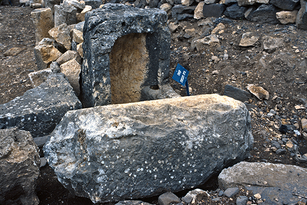
In the north wall of the synagogue, an installation that resembles a charity chest or community treasury has been found.
The community treasury. Photo: Leen Ritmeyer 1988.
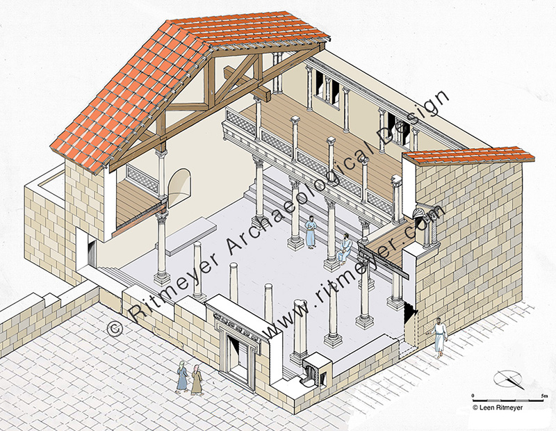
The synagogue had the shape of a basilica and was oriented north-south and measured 20 by 18.5 meters. In contrast to the village houses that were built of dark basalt, the synagogue was constructed of limestone blocks. The interior had three rows of pillars with heart-shaped pillars in the corners and four steplike benches were built along three of the walls.
A round niche for the Torah ark was later constructed in the southern wall, with a stone platform (bema) in front of it for the reading of the Torah. Such a feature was characteristic of later synagogues. There was also an additional entrance made in the middle of the north wall at this time. This new axis from north to south was designed to direct worshipers to face towards Jerusalem when they entered the synagogue through the northern entrance.
The three rows of columns on the first floor had Corinthian capitals, while those of the second story were topped by Ionic capitals. Smaller Ionic pilasters, flanking double windows, adorned the walls of the upper story.
Reconstruction of the Arbel Synagogue by Leen Ritmeyer.
A large, paved courtyard was made in front of the main entrance. It may have served as what is called in rabbinic literature a “door within a door”, that is a kind of entrance room or place of assembly. The building was topped by a tiled roof.
The Arbel Synagogue continued to function until the earthquake of 747 AD, when it was severely damaged, and the settlement destroyed.
Judith Sudilovsky reported in the Jerusalem Post on the opening of the Arbel Fortress following 1.5 years of conservation work.
“Towering majestically over Lake Kinneret, looking out over a breathtaking view of the upper and lower Galilee including Mt. Nitai, and further towards the Golan Heights and Mt. Hermon, the stark cliff of Mt. Arbel has been witness to plenty of history.”
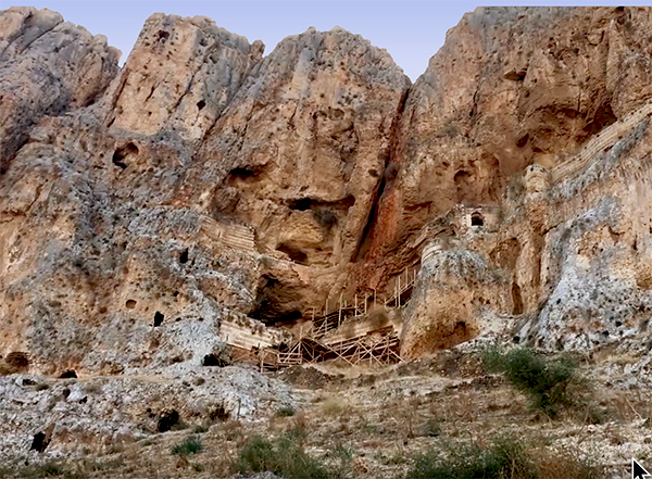
The cliff hanging Arbel Fortress in question is known as Qala’at Ma’an. It was built in the beginning of the 17th century AD by Fahr al-Din II, of the Druze Ma’an dynasty, governor of Lebanon and Galilee.
The Arbel Fortress in 1988 showing its precarious state of preservation. Photo: Leen Ritmeyer.
“The fortress was not allowed to stand for too long, and within a decade of its construction Ottoman forces destroyed it for reasons unknown. Time and nature did their share, and over the centuries the three-story fortress—a popular site for intrepid hikers to visit–fell into great disrepair making it dangerous for visitors.”
Reconstruction of the Qala’at Ma’an Fortress.
Despite its short existence and subsequent neglect by both nature and pillage by men, the Arbel Fortress still has an imposing presence hanging halfway down the cliff. We are grateful for this conservation project that makes the site more accessible for visitors who can also enjoy the spectacular views of the surroundings.
View through Wadi Hammam (Valley of the Pigeons in Arabic) to the Sea of Galilee. The Arbel cliffs are on the right and Mt. Nitai on the left. Photo: Leen Ritmeyer.
Arbel is a site of uncommon natural beauty with steep cliffs plunging down toward the Sea of Galilee, overlooking Wadi Hammam, Magdala, the place where Mary Magdalene lived, and Capernaum.
The steep cliffs viewed from the Arbel lookout point. Photo: Leen Ritmeyer.
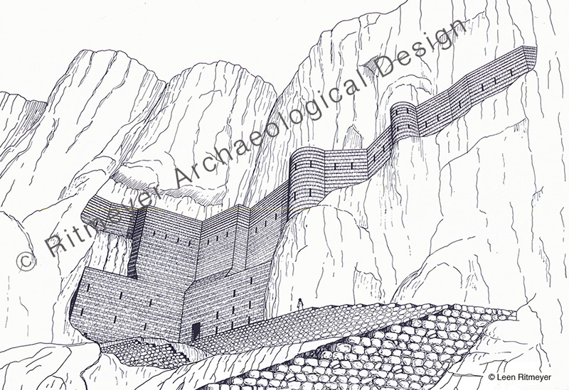
For a long time, it was thought that Fahr al-Din’s citadel was the fortress of the Jewish rebels who fought against Herod. The late Zvi Ilan conducted a systematic survey of these caves in 1987- ‘88, in which I participated. The actual caves were located on a trail on which, for decades, hikers walked to the Ottoman fortress. Initially, Zvi had no idea that the real caves were hidden only a few meters away! During the Hasmonean period, about one hundred caves were hewn in the cliff for residential purposes and protected by walls. Some caves contained two or three rooms. The survey showed that the outer wall of the fortress of Fahr al-Din was built in front of some of those Hasmonean caves. This caves consisted of rooms, cisterns, stairways and even a mikveh that was found on the third floor.
This section, taken behind the outer walls of the fortress of Fahr al-Din, shows that it was built in front of Hasmonean caves. On the upper level a mikveh was found showing that these caves were occupied by religious Jews.
To his great surprise, Zvi Ilan discovered another cave fortress to the east of the Ottoman fortress that was 75 meters long, 14 meters wide and 10 to 12 meters high. A long wall was built in front of it, to the top of the hewn rock. An interior wooden walkway was constructed between the caves and the wall. The date of this fortress could not be established without a future excavation. However, according to Zvi, the possibility that this fortress was built as part of the preparations for self-defence at the site at the end of the Second Temple period, should not be ruled out.
This fortress was probably built as part of the preparations for self-defence by Jewish rebels in the cliffs of Arbel at the end of the Second Temple period.
As mentioned in Judith’s article, Arbel has seen plenty of history even though it is so little known. What is known about its history?
The ancient settlement and lookout post of Arbel may have been the one that is mentioned in the Bible as Beth-Arbel. This fortress was destroyed by Shalmaneser V in 722 BC, when he was on his way to capture Samaria: “all your fortresses will be devastated – as Shalman[eser] devastated Beth Arbel on the day of battle, when mothers were dashed to the ground with their children.” (Hosea 10:14). The defeat of this settlement must have been particularly brutal and an example to Israel of the cruelty of the Assyrian invaders.
The fertile land on the Valley of Arbel that is watered by the abundant water that flowed through it, enabled the inhabitants of Arbel to grow grain, olives and grapes, and flax that was used in the production of linen. This supported a strong economic base for Arbel that was built on terraces in the rocky slope on the northern periphery of the Arbel Valley.
The fertile Arbel Valley is visible at top left behind the Arbel Synagogue. Wikipedia.
Two great legal minds of the mid-second century BC, the sage Nitai the Arbelite, who was born here, and Joshua ben Perahiah taught Torah using a Deuteronomy scroll that these two sages had received from Simon the Just, who was then High Priest in Jerusalem (Mishnah Avot 1:6). Nitai was also vice-president of the Sanhedrin. This indicates the high level of development of Arbel as a spiritual centre for Galilee.
The ancient settlement was almost entirely surrounded by cemeteries. Later traditions mention Arbel as the burial place of Nitai of Arbela; Dinah the daughter of Jacob, and several of her brothers; and that of Seth the son of Adam, and the exilarch Hezekiah, a leader of the Jewish community from the time of the Babylonian exile.
Arbel is now also known for its unique system of the above-mentioned fortified caves where Hasmonean loyalists fighting the Galilean Zealots hid. In 161 BC, a deadly battle took place at Adasa between the Maccabean forces led by Judas and the Seleucid forces that were commanded by Nicanor. The Seleucids were defeated and Nicanor was killed. In order to revenge his death, Demetrius the Seleucid king sent his general Bacchides the following year to the land of Judea. “They took the road to Galilee and besieged the Mesalot (fortified caves) in Arbel and captured it and put many people to death” (1 Mac. 9:2).
In 38 BC, Herod tried to conquer the land with Roman support and battled the supporters of Antigonus II, the last Hasmonean king of Judea, who were hiding out in these caves. Herod’s men fought for forty days to no avail. Herod then devised a plan whereby soldiers would be lowered from above in crates connected to iron chains. After a bloody battle, Herod’s forces eventually routed the Jewish rebels.
King Herod defeats the Israelite rebels hiding in the rock cliffs of Mt. Arbel by lowering Roman soldiers down in chests. Etching by Jan Luiken, 1649-1712.
In 66 AD, at the beginning of the First Jewish-Roman war, Josephus fortified the caves with walls and used them as storage base at the beginning of the First Jewish-Roman war.
After the Roman destruction of Jerusalem in 70 AD and the Bar-Kochba rebellion that lasted from 132-136 AD, many Jerusalem Temple priests fled to villages in Galilee. It was then that the association of Arbel with the concept of Messianic redemption became widespread. One poet from Tiberias claimed to have seen an appearance of the Messiah in the plain of Arbel on the eve of Passover.
In the fourth century, a synagogue was built in Arbel (see image above), which we will report on in the next post.
Thanks to the conservation work, both these fortresses and the caves can be safely visited again, a wonderful opportunity for hikers and people that love the land. These caves are also located on the Jesus Trail. This is a 40 mile (65 km) long hiking and pilgrimage route following the road that Jesus would have taken when he moved from Nazareth and went to live in Capernaum. It goes through the Wadi Hammam that is located between the Horns of Hattin of Crusader fame, or rather infamy. Hikers will surely enjoy seeing the renovated Ottoman fortress and the many caves that bring history to life.
My friend and colleague Hillel Geva, director of the Israel Exploration Society and editor cum publisher of the Jewish Quarter Excavations in the Old City of Jerusalem Conducted by Nahman Avigad, 1969-1982, sent me a copy of Volume VIII of this important series. Hillel is to be congratulated on the preparation and publication of this beautiful volume which sets a high standard of how excavations should be studied and published.
The cover photograph of Vol VIII shows Hillel sitting at right near the bathroom of the Palatial Mansion. The mosaic floor of the bathroom was decorated with a colorful rosette. The residents would have enjoyed the spectacular view of the Temple Mount and the Mount of Olives in the background.
This Volume VIII describes the excavation of the archaeological remains of the Palatial Mansion, which, as suggested by Avigad, may have been the Palace of the High Priest[1]. This mansion may have been built by Annas who was High Priest from 6-15 AD, as he was one of the few people who could have afforded to build such a large and lavishly decorated residence. The family of Annas was very wealthy as they controlled the Temple Market that was set up in the Temple Courts and out of bounds for normal moneychangers. Josephus called one of the sons of Annas “a great hoarder of money”.
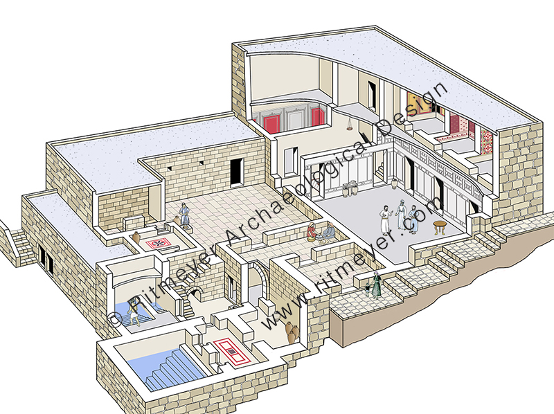
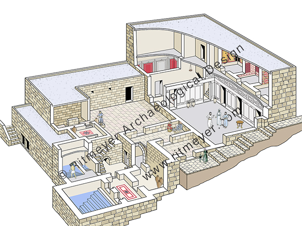
This building covers 600 square meters and is one of the largest residences dating from the Second Temple period ever uncovered, not only in Jerusalem, but in the whole of the country. This mansion is located on the eastern edge of the southwestern hill which slopes down to the Tyropoeon Valley. Overlooking the Temple Mount, it would have been considered prime real estate in the 1st century AD, as indeed it is today.
In the first chapter of this magnificent volume, Hillel describes the stratigraphy and architecture of the Palatial Mansion in great detail. The structure is built on two levels, each consisting of two stories and has many rooms built around a central open courtyard. The walls of several of these rooms were decorated with fresco and stucco designs. Seven rooms had mosaic floors, three of which were decorated with colorful carpets.
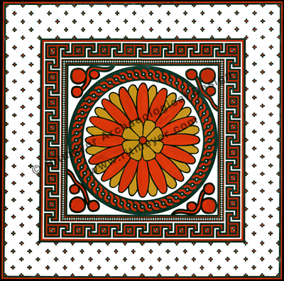
The floor of the vestibule of the Palatial Mansion was decorated with this beautiful mosaic design. It had a central rosette surrounded by circular and square frames. Pomegranates can be seen in the corners between the round and square designs. This reconstruction drawing was made for a model of the mansion that was exhibited for many years in the central courtyard.
Eight mikva’ot (ritual baths), catering for the purification requirements of the residents, were found in the mansion indicating that the complex was occupied by priests who served in the Temple.
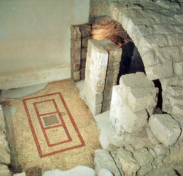
The mosaic floor in front of the double entrance to a mikveh. Photo: Leen Ritmeyer.
After making the publication drawings and studying the architectural remains, I made this new reconstruction drawing to give an overall idea of what the mansion may have looked like:
A perspective reconstruction drawing of the 6,500 sq. feet (600m2) residence dating from the Second Temple period and found in the Jewish Quarter excavations in Jerusalem. Known as the Palatial Mansion because of its unusually large size, it is now part of the restored Herodian Quarter. Its overall plan, centred round a paved courtyard, makes it clear that it was one living unit and was not divided into smaller residences. A narrow street ran along its northern side. The sumptuousness of its fittings makes it worthy of the term “palace”. It contained eight ritual baths, one evidently built to serve a number of people with one door for entry and one for exit as seen in the lower foreground.
In this volume, every wall and locus is recorded and accompanied by photographs, plans and sections. Of necessity, this takes up the bulk of the book. Different authors have written short chapters on the fresco and stucco decoration, mosaic floors, and ritual baths.
The building was destroyed by the Romans in 70 AD, while it was in the middle of undergoing extensive renovations with fresco wall decorations being covered over with white stucco. This consisted of broad panels in between two bands of imitation masonry, modelled on “headers and stretchers.” However, on the basis of the stucco remains of the northern wall of the Reception Room that extended to the greatest height, it was clear that there was an additional band of decoration just below the ceiling. This different style of imitation stone work could only be reconstructed on the basis of a complete panel which was found in the debris on the floor below this wall – see reconstruction drawing below.
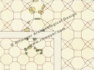
The floor was also found littered with small fragments of decorated stucco with different patterns, which had fallen from the ceiling. Before restoration work on the Palatial Mansion began, Avigad presented me three large trays of a representative sample of ceiling fragments and asked me to try and make some sense of them.
All the pieces showed geometrical patterns in relief. It was clear that the original design must have been divided into two parts, as some fragments had an “egg-and-dart” motif and the remainder were plain. Measuring the angles in the first group – squares, octagons and triangles of 45 degrees could be discerned. The second group consisted of squares, hexagons and triangles of 30 degrees. After trying out various possibilities and taking into consideration the dimensions of the room, the number of fragments found and their representative proportions, I hit upon this ceiling design which was later partially incorporated in the restoration.
I was not part of the original team, as I was then working as architect on the Temple Mount Excavations. However, since 1978, I have spent many years working on the publication plans of all the excavation areas of the Jewish Quarter Excavations. Each of the publication plans, elevations and sections of this magnificent residence including reconstruction drawings, were prepared by me on completion of the excavation.
It should be noted that this volume, like the previous ones, is a scientific publication and of interest to archaeologists, historians and the interested lay person. Other readers may be more interested in a popular book, such as that published by Avigad, who summarised the excavation of this extraordinary mansion in his book Discovering Jerusalem[2]. This Vol VIII is the complete excavation report, published some 30 years after the first spade went into the ground.
When the excavations were finished, a four-story high modern building, the Yeshivat Hakotel (a Jewish school for the study of the Torah and the Talmud) was built over the preserved remains. The mosaic floors were removed and, after conservation, exhibited in the Israel Museum. On completion of the building of the yeshiva, an archaeological museum, named the Herodian Quarter, or Wohl Archaeological Museum, was planned in what had become the basement of the new building. Avigad planned and directed the work for two years, from 1985-87, putting me in charge of its execution. He visited the site twice a week for a couple of hours, leaving me in charge for the rest of the time.
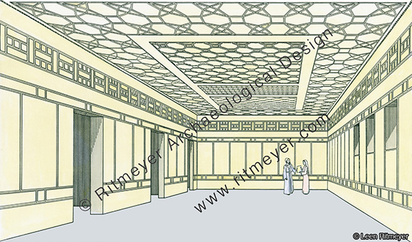
Although in this Volume VIII, only just over two pages are dedicated to this restoration work, it required a lot of thought as to how best to preserve the remains and how to decide where to add stones. Some of the the walls were made higher to help the visitor with spatial orientation. The restoration of the Reception Room demanded special attention as we tried to give an impression of what the beautiful stucco decoration of both the walls and ceiling would originally have looked like. This restoration work was published in book form by Avigad[3]. I treasure my copy of this book which he gave me, inscribed with the dedication “a souvenir from a joint work”.
This large and elegant room, which measured 18 feet (6.5 m) wide and 36 feet (11 m) long, was undoubtedly the Reception Room of the large Palatial Mansion excavated in Jerusalem. The walls of the room were decorated with panels of stucco and it had an intricately designed ceiling. If this was indeed the palace of Annas the High Priest, then Jesus may have stood before him in this hall (John 18.13, Acts 4.6).Here we see the partially restored Reception Room. The lighter color on the wall in the centre of the photo shows the added reconstruction. On the right are photographs of David Simon, an expert plasterer originally from Iran, and myself, working on the reconstruction of the stucco designs. The concrete pillar in the middle of the room is part of the support structure of the yeshiva building above. Photo: Nathaniel Ritmeyer.
This volume is a worthy addition to the previous seven volumes of the Jewish Quarter Excavations which cover the excavations of the Broad Wall, the Israelite Tower (later identified as the Middle Gate of Jer. 39:3) and other fortifications, the Byzantine Cardo and the Nea Church, and other buildings of the Second Temple period.
Avigad passed away in 1992 and therefore was unable to publish the final reports of these important excavations directed by him. We are grateful that Hillel Geva, who served as archaeologist since the beginning of the dig, has taken upon himself to publish the results in such magnificent volumes. The next volume will describe the many small finds that were discovered in the Palatial Mansion.
During the reign of Constantine the Great (306-337) and especially after his conversion in 312, Christianity spread rapidly in the Byzantine Empire and even more so in the Holy Land. After the visit in 326 AD by Queen Helena, Constantine’s mother, many Gentile pilgrims came to visit the Holy Land. Some remained and chose to live lives of seclusion in remote areas such as Sinai, around the Sea of Galilee, in the Judean Desert, and in Samaria, while others lived in towns and cities.
In the wake of this influx of pilgrims from the Byzantine Empire, the prominence of the domus ecclesia diminished and larger buildings became necessary to accommodate the many worshipers. Church buildings came into the ascendency, and their construction became the primary architectural focus during the later Byzantine period. Two kinds of churches developed: the basilica with its long hall, and the centrally designed (circular, octagonal, or hexagonal) memorial church. Basilicas were mainly used for communal worship, while the centrally designed churches commemorated special Biblical places or events.
During this time, the Gentile Christian population of Capernaum had increased dramatically and outnumbered the Jewish Christian members of the congregation. Radical changes were made to create a new Byzantine-style church inside the fourth century enclosure wall.
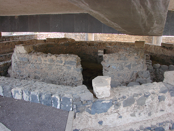
The basalt foundation stones of the octagonal church and some limestone blocks of the superstructre are visible beneath the concrete beams of the modern church. Photo: Leen Ritmeyer
Substantial remains of the foundations of an octagonal church, that dated to the fifth century and was built with limestone blocks, were excavated in Capernaum. This limestone that came from the Arbel region could be carved easily and polished to a high degree. In the first half of the fifth century, the buildings that stood inside the enclosure were demolished and covered over. Instead of the domus ecclesia with its explosion of colour of the fourth century, a new and monumental was built in its place.
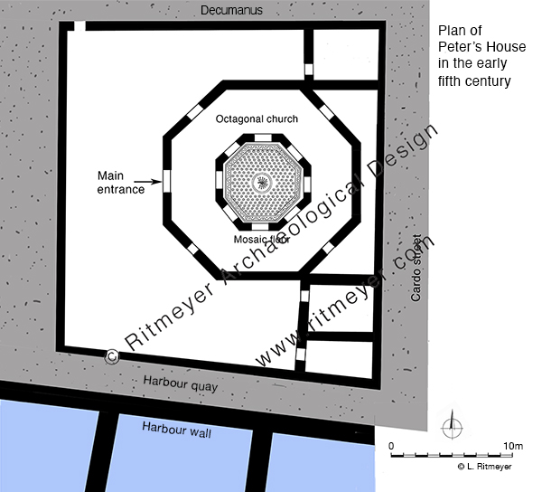
The walls of the inner octagon, which measured 7.9 m (26 feet) across, were built on the basalt foundations of the domus ecclesia and then another octagon, measuring 16.53 m (54.2 feet) across was added around it to complete the first phase of the new church. The church was paved with mosaics. The centre of the inner mosaic has a medallion with a peacock design, apparently symbolising immortality to the early Christians. Annexes were built to the west of the church and in the northeast and southeast corners of the square enclosure.
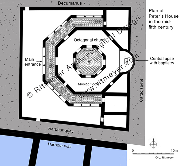
Sometime in the second half of the fifth century, a partial octagonal porch was added on the north, west and south, and an apse containing a baptistry on the east. This apse was constructed on the other side of the east wall of the enclosure.
The baptistry had steps leading down to it, indicating that adult baptism by immersion was practised in the fifth century.
After the Islamic invasion of 638 AD, Capernaum was abandoned and the church and synagogue, that had existed side by side, fell into ruin. After the earthquake that hit Galilee in 749 AD, Arab inhabitants began to systematically rob the buildings of their stones, leaving precious little for future archaeologists to investigate.
In 1866, Captain Charles Wilson exposed some foundations of the synagogue, with the unfortunate consequence that local people began to dig deep into the ground near the synagogue and near the church to find more limestone blocks which they either sold as building material or burned into lime. Other contractors used the exposed ruins as a quarry.
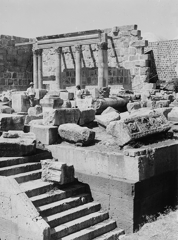
To stop this looting the Franciscan Custody of the Holy Land acquired the site in 1894 and exploratory excavations were conducted in 1905 by Heinrich Kohl and Carl Watzinger. Other excavations were conduction under leadership of F. V. Hinterkeuser and these continued until the outbreak of World war I, After the war, excavations were resumed by Gaudenzio Orfali until 1921. Orfali initiated the restoration of the Byzantine synagogue in 1922-1925.
The results of Orfalo’s restoration. Photo: Matson Collection.
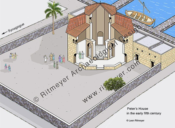
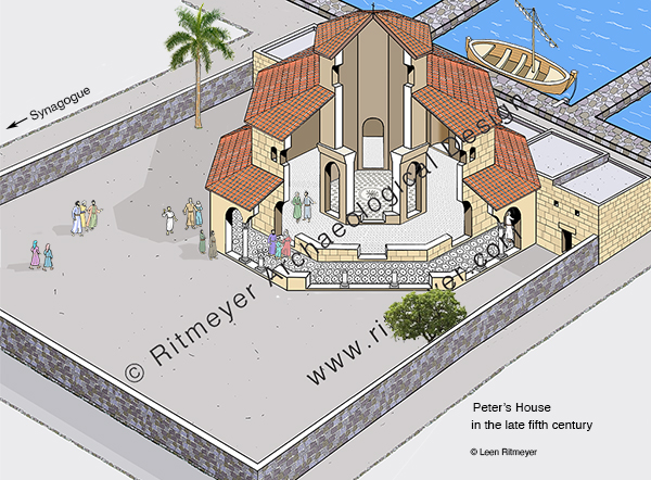
In 1968, Virgilio Corbo and Stanislao Loffreda continued excavating Capernaum and conducted eighteen campaigns until 1985, and the restoration of the synagogue was continued by Corbo since 1969. It would have been great if similar efforts would have been put in the restoration of the Byzantine church, but unfortunately that won’t happen unless that new and incongruous UFO-like modern church that was built over Peter’s House (designed by the Italian architect Ildo Avetta and dedicated in 1990) would start its engines and fly off!
Nevertheless, it is thanks to the labours of the Franciscan Custody of the Holy Land that tourists and pilgrims can visit Capernaum again and see the place that was made famous when Jesus chose it as his hometown.
the domus ecclesia from the first to the fourth century
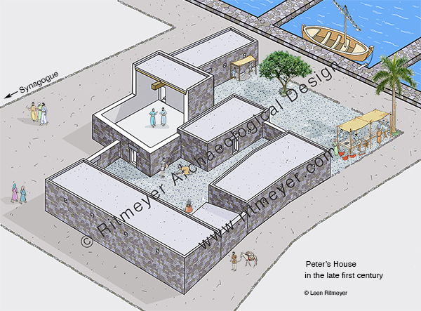
In our previous post we wrote that the House of Peter eventually developed into a church. It was a slow process that took four centuries. The first stage began in the second half, or perhaps even at the end of the first half of the first century, when the east courtyard transformed into a large room. While before the sky was its ceiling, this large space, measuring 5.80 by 6.45 m (21 by 19 feet) was now roofed over. A central wooden beam placed on top of the walls divided the ceiling into two parts so that shorter beams could be used to span the large room.
Several layers of plaster were found on the walls and the floor. Quite unusually, this is the only room in Capernaum that was plastered at this time, pointing to the use for non-domestic purposes. There was also a change in pottery. Beneath the plastered floor, the usual repertoire of domestic vessels, such as cooking pots, bowls and juglets, was found. Above the plastered floor, however, only storage jars and oil lamps were discovered.
Reconstruction of Peter’s House in the late first century.
Who worshiped in this sacred space? After Pentecost, the early Christian believers “devoted themselves to the apostles’ teaching and the fellowship, to the breaking of bread and the prayers” (Acts 2:42), and according to Acts 2:46, this was done “in their homes”, or “from house to house”. The archaeological evidence points to the use of this plastered room in Capernaum as a large house-church or domus ecclesia. This space is sometimes referred to as the ‘venerated room’.
Until the 4th century, the population of Capernaum was entirely Jewish, and the Synagogue of Capernaum continued to operate as normal. The people that worshiped in the domus ecclesia were Jewish converts to Christianity, called minim by the rabbis:
“In passages referring to the Christian period, minim usually indicates the Judæo-Christians, the Gnostics, and the Nazarenes, who often conversed with the Rabbis on the unity of God, creation, resurrection, and similar subjects (comp. Sanh. 39b). In some passages, indeed, it is used even for “Christian”; but it is possible that in such cases it is a substitution for the word “Noẓeri,” which was the usual term for “Christian.”
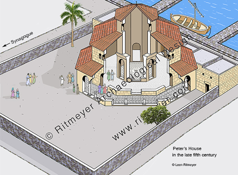
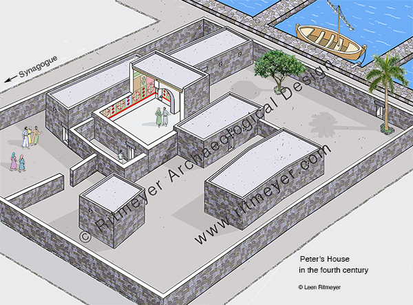
In the late fourth century, at the initiative of Count Joseph of Tiberias, who was a friend of Constantine the Great, major changes took place in the development of Peter’s House. An approx. 120m long enclosure wall was built around Peter’s House, turning it into an almost square sacred compound, or insula sacra. Some of the first century rooms were destroyed to create more space around the domus ecclesia, giving the whole complex a stronger religious character.
There were two entrances in this enclosure wall, one in the north and one in the south. Interestingly, no entrance was made in the east wall to the Cardo street, the main north-south road on which the synagogue was located. Instead, a new east-west street (decumanus) was constructed north of the complex. Is this an indication that the two communities, Jewish and converts to Christianity, tried to remain separate?
Reconstruction of Peter’s House in the fourth century.
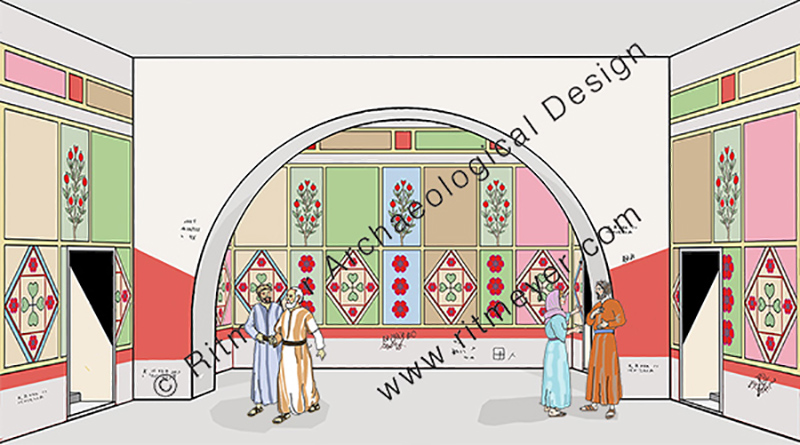
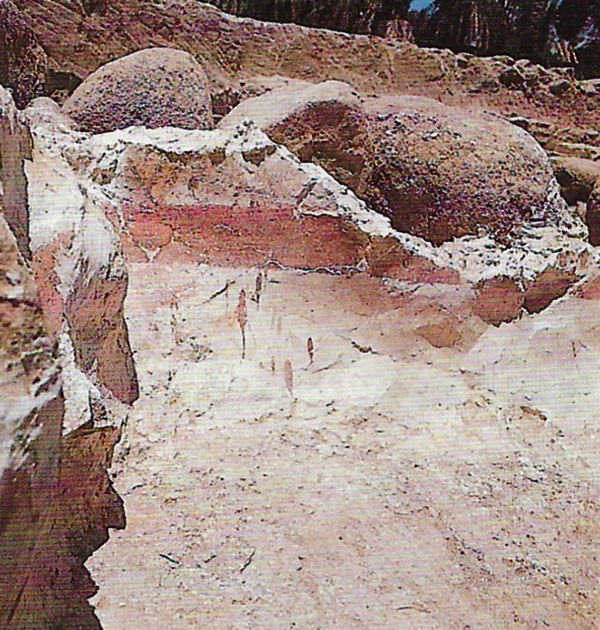
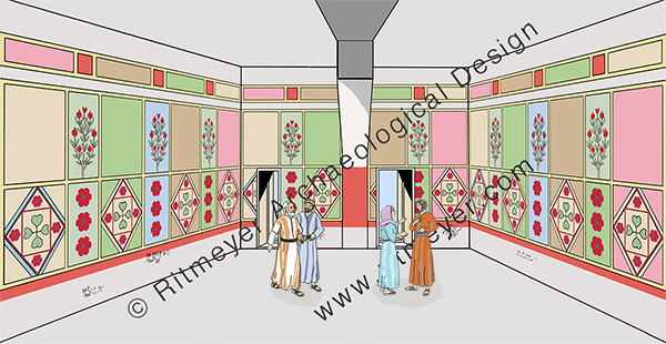
The domus ecclesia room was also changed. A central arch was built in the room to support a higher ceiling, and the walls of this room were decorated with fresco. Various colours, such as red, pink, yellow, brown, green and white were used to create rectangular panels with alternating geometric and floral designs.
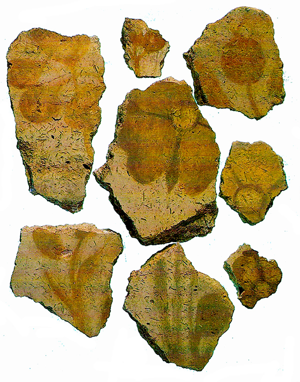
Broken fresco remains found in the domus ecclesia, photograph by Stanislao Loffreda.Remains of fresco in the southwest corner of Peter’s House, photograph by Stanislao Loffreda.
In line with Jewish practice, no human or animal forms were portrayed. Inscriptions, or rather graffiti, in Greek, Latin, Syriac and Aramaic were scratched in the walls by apparently Christian pilgrims. Some of these graffiti mention monograms of Jesus and of Christ. The name of Peter is one of the many inscriptions scratched on the walls.
Reconstruction the house church in Peter’s House, looking east.Reconstruction the house church in Peter’s House, looking south.
On the northern side of the domus ecclesia, a sacristy was built where were usually sacred vessels and vestments were kept. On the east side an atrium was added which served as an entrance hall to the main room. This shows that in the fourth century the Jewish Christian population had increased substantially but were still living side by side with the Jewish people of Capernaum. All this was going to change in the fifth century when there was a huge influx of Gentile Christians …