50 years of visualising the Bible

Fifty years ago today, I embarked on a career which previously I hadn’t know existed and couldn’t have dreamed up for myself. It combined the disciplines of archaeology,  ancient architecture, history, education, and Biblical Studies. Since realising, a few years later, that this would require the wearing of multiple hats, (although my fedora was the one that was most practical and the one that became identified with me), I got used to various titles like: “Archaeological Architect”,“Conservator” and “Lecturer”. However, I soon learnt that the hat of Bible Student was the most valuable, and that which could encompass most of my interests. My studies of the Bible had taught me core skills that could be useful in many situations. Research, analysis, interpretation, and application, to mention but a few, all could be improved and enhanced by immersion in the Good Book. 

A few months ago, one of my sons, Ben, was looking at a book that contained drawings of cities from Biblical times with one of his sons, Seth ( my now 5-year-old grandson). Ben mentioned that some of these sites were thousands of years old. Seth exclaimed: “as old as Grandad!” Now, I do not claim to be thousands of years old.

Grandson Seth at my computer desk

But when I looked around my workroom/studio in the cottage we now live in South Wales, I realised that within its walls lie physical evidence of 50 years of visualising the Bible. Its main holding is a substantial library of volumes that contains many of my reconstruction drawings. Some of the most well-known are Study Bibles and our own books, most of which have been published by Carta of Jerusalem. There are traditional dig reports and guide books too. And, added later, also items of a more unusual shape, like CDs and DVDs.

So – if this turning of the year makes you feel like hearing the story of Ritmeyer Archaeological Design, gather round and I will try my best to tell it. And for those of you who on occasion have asked: “How can we learn to do what you do?”, you may pick up some hints or feel that you have had your fill already.

A Dutchman, I graduated in 1967 with a degree in Physical Education from Arnhem. At that time there was compulsory military service, and within a week all my friends had been enlisted, but I was the only one not called up. As I could not commit myself to at least one year of teaching, I decided to go and travel until the military call-up arrived.

After the Six-Day War, there was a shortage of manpower in Israel, as most men were still mobilised. So, I volunteered in Kibbutz Yad Mordechai near the Gaza Strip and stayed there for almost half a year. I used my free time to travel through the Land, began to read the Bible and learnt Biblical Hebrew. The combination of knowing the geography of the Land and learning Hebrew greatly increased my understanding of the Scriptures and developed in me a love for the Land that only got stronger over time and never left me.
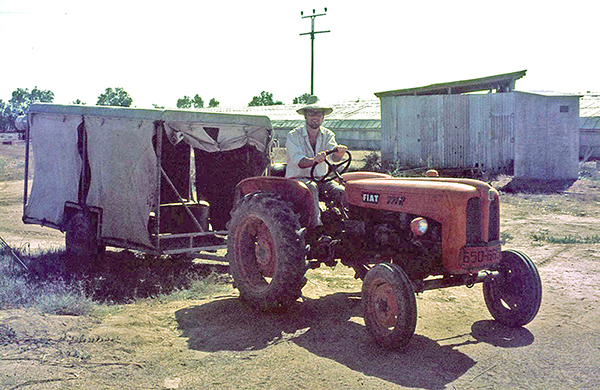
Driving a tractor at Kibbutz Yad Mordechai

In 1969, I decided to try and settle in Israel, which as a non-Jew was not easy, but I eventually found work on the Temple Mount Excavations under the direction of the late Prof. Benjamin Mazar (1906-1995). Before finding this position, I had written a letter to David Ben-Gurion, the former Prime Minister of Israel and was granted permission to stay as a temporary resident. I held this status in fact, for twenty years – a permanent temporary resident!

And reflecting on the way I had originally found the job on the Temple Mount Excavations, it also seemed pretty fortuitous.  In 1972, I had read a report about the Temple Mount Excavations in which they appealed for more staff. My late sister Martha had got a job illustrating ancient architectural elements when she applied. She did very well at this work, which she liked very much. We decided to move from the area of Petach Tiqva (Door of Hope), the area where we had been living and earning a livelihood, and we found a house in Bethany near Jerusalem.
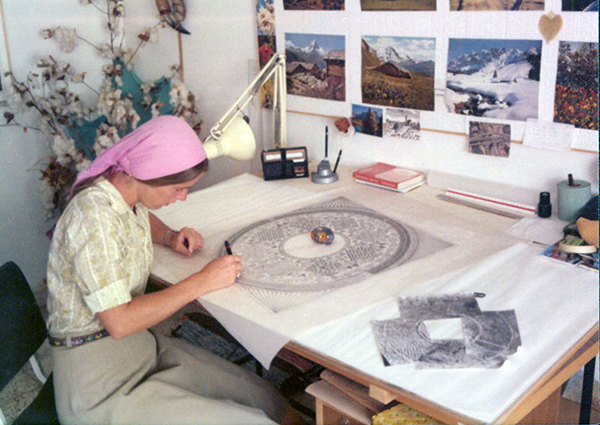
My late sister Martha drawing one of the domes in the Double Gate passageway

After hearing from Martha that I was also looking for work, the deputy director of the dig, Meir Ben-Dov, asked me to come and work there too. I was not too enamoured when I saw the dig with its broken stones and walls and volunteers slaving away in the dust and heat. He offered me the job of drawing potsherds in a tiny room that was a converted cupboard. I ran away as fast as I could! However, he persisted and eventually offered me the job of surveyor. I had never done anything like that but replied that I knew where the zero on the tape measure was and was ready to give it a go. 
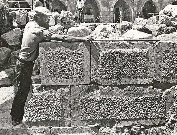
Surveying an ancient wall

So, on the 1st of January 1973 I started to work as the dig’s surveyor, making plans on a scale of 1:50. An Irish architect, Brian Lalor, later to achieve renown in his own country in the field of printmaking, trained me in and I liked the work. When I showed him my drawings, I observed what he did with them. He reduced my plans and then completed broken or missing walls and reconstructed elevations and then made complete reconstruction drawings of the building remains that I had surveyed. I thought this was fantastic and, seeing that I was interested, Brian gave me a Byzantine bath house to reconstruct, a work that quickly drew me in. 

The great joy in archaeological excavations is figuring out how architectural structures worked. A couple of months later I was asked to survey the Herodian shops to the east of the Triple Gate. These shops were at a much lower level than the street in front of this gate. It was obvious to me that the roof of these shops must have supported the street above. I asked Brian what kind of roofs they might have been, but the response was unclear. One morning, when the sun was shining at just the right angle, I looked up and saw the burnt imprints of arches in the Southern Wall of the Temple Mount and figured out that the descending stepped street above must have been built over the vaulted ceilings of these shops. The shops had been burnt down by the Romans in 70AD, but before the vaults collapsed, the fire burnt into the Temple Mount wall, leaving the imprints of the vaults as an evocative testimony to this dreadful inferno!
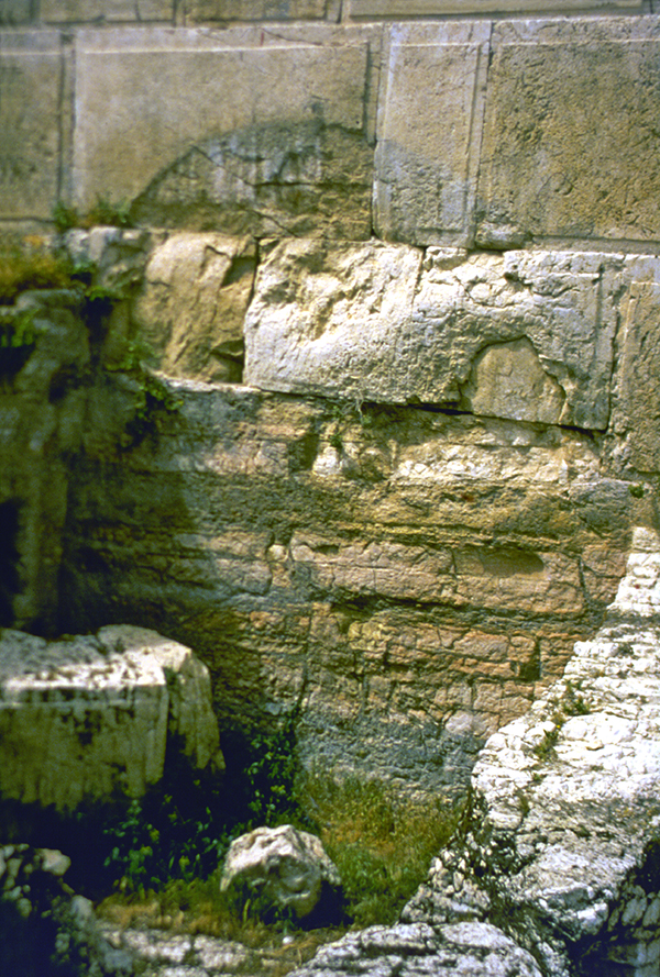
The burnt imprint of the vault closest to the Triple Gate

My theory at first was greeted with unbelief, but when Prof. Mazar and Brian came to have a look, they were bowled over when they saw the actual evidence. The difference in height between these vaults was 60 cm (2 feet). This corresponded to the height of three steps. And so, it was possible to make a watertight reconstruction of the street above the shops. The excitement and thrill of this discovery got me hooked on ancient architecture for life.

The difference in height between the burnt arches corresponded to three Herodian steps.

Four months later, Brian left to return to Ireland, and Benjamin Mazar told me to sit in the architect’s chair and to continue supervising a small team of volunteer surveyors that I had trained in. I was left in charge of the architect’s office, and that is how my career as an archaeological architect took off. During the winter months of 1973, Mazar sent me to the library of the Rockefeller Museum to study ancient architecture under his personal guidance. 
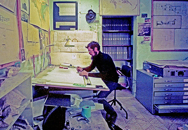
In the architect’s office

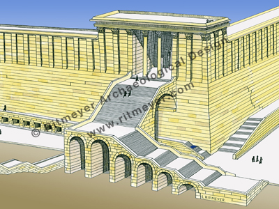
The making of reconstruction drawings, that became my speciality, was born out of necessity. Apart from my regular architectural work, some staff members including myself, gave tours to other archaeologists and visitors. It was this experience that convinced me of the necessity for these drawings. One of the first stops on the tour was Robinson’s Arch, one of the four gates in the Western Wall of the Herodian Temple Mount. I tried to explain the features of the arched staircase that led up to the Temple Mount from the street below, sometimes using my hands and feet. From questions I received afterward, I realized that not everybody could visualize how it worked. I then made my first reconstruction drawing of Robinson’s Arch. On this drawing, I indicated in color the visible remains and drew the reconstruction in black and white lines. This visual connection with the archaeological remains made the reconstruction immediately recognizable. Seeing people’s faces change from incomprehension to clear understanding assured me that this was the way to go.

Reconstruction drawing of Robinson’s Arch

Eventually, my reconstruction drawing of the Temple Mount that was used by many guides, became a classic and has been published in many books.
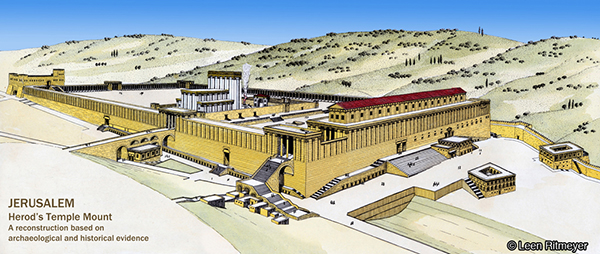
During the Yom Kippur war in October 1973, Israel captured large areas of Syria from Kuneitra to halfway down to Damascus. This area was referred to as the Bashan. After the fighting was over, the soldiers who were archaeologists went back to their normal Unit for the Knowledge of the Country. They had to do an archaeological survey of the Bashan and found two-story Roman houses that had recently been lived in still standing up.

As the archaeologists couldn’t make architectural plans, I was employed by the Israel Defence Forces (IDF) to join this unit. This was very exciting, as this was my first visit to Syria and I got to know all the up-and-coming young archaeologists, such as Amihai Mazar, Dan Urman, Zvi Ilan and Amos Kloner.
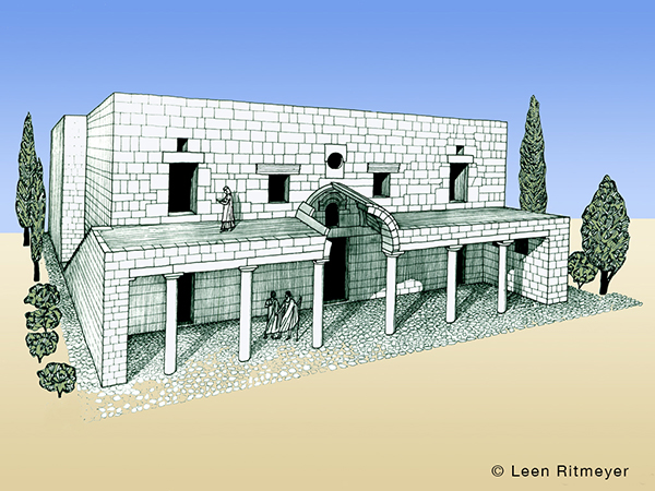
A Roman house at Kafr Nasj in the Bashan

Later, some of this group asked me to make drawings for them. Amihai employed me to draw up the plans of the Tel Qasile excavations and later asked me to join the Tel Batash (Timnah of the Philistines) dig, Dan Urman asked me to join the Tel Nitzana excavations and draw up the plans of Rafid on the Golan, Zvi Ilan asked me to make a reconstruction drawing of the Byzantine Synagogue that he had excavated in Meroth, and for Amos Kloner I drew up some of the caves of Bet Guvrin.
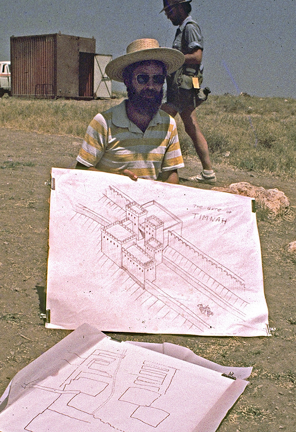
Reconstruction drawing of the Gate of Timnah

Back at the Temple Mount excavations, I finalised the survey plans, and made reconstruction and publication drawings of buildings belonging to different periods. Prof. Benjamin Mazar was interested in the Herodian and earlier periods, while Meir Ben Dov was given responsibility for the later periods. From my office room I could see who was coming down the steps to see me. When Mazar came down, I quickly put the Herodian drawings on my desk and exchanged them for later period drawings when Ben Dov was visiting!

Another chapter in my career opened when I was asked to reconstruct the Crusader Church of Saint Mary of the Germans in Jerusalem. This work involved the building of a staircase and the pillars that once supported the vaults of the hospital hall of the hospice complex in the Jewish Quarter of the Old City. To make the pointed arches, I cut templates out of carton for the individual arch stones on the flat roof of our house in Melchizedek Street and gave those to masons in Bethlehem who cut the stones and built the arches.
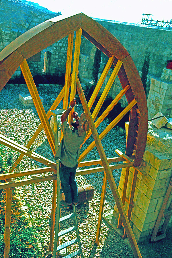
Inspecting the wooden centering – a temporary frame to support an arch or vault during construction

It was the first of several restoration projects I later became involved in, eg the Byzantine Cardo and the Herodian villas in the Jewish Quarter of the Old City of Jerusalem. Restoration consists of consolidating the actual remains to prevent deterioration. At times, it is important to reconstruct parts of the ancient ruins. This is extremely sensitive work. It is very important not to build up the site too much, but to do it so that one gets a real feeling for how it would have looked originally.

My life changed in 1975, when Kathleen, an Irish archaeologist, came to work on the Temple Mount Excavations. I still remember her joining the tour I was giving on the dig at the southwest corner, but had no idea that eventually she was to become my beloved wife. She was certainly the best find ever! 
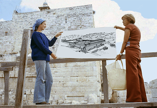
Kathleen at left using my Temple Mount reconstruction drawing during a guided tour

In 1983, Kathleen and I established a partnership called Ritmeyer Archaeological Design (RAD), which is an independent partnership devoted to archaeological reconstruction and the production of educational materials, and it is still active today. Kathleen’s excellent writing and research skills enabled us to produce books and varied educational materials that people still find useful today. Just as much as I like drawing lines on paper, she says that she loves to “push words around the page!” Working together has been a great blessing, as we have similar interests and complement each other.

Much of my time in Israel then involved the restoration, first of the Byzantine Cardo and the Herodian Quarter in the Jewish Quarter of the Old City, later called the Wohl Museum. 
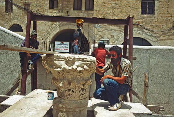
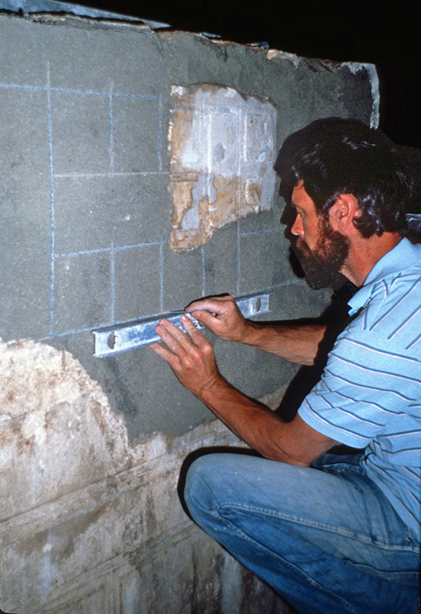
Checking the position of a capital during the restoration of the Byzantine Cardo.
Drawing the design of the stucco decoration in the Reception Room of the Palace of Annas the High Priest.

In 1989 we moved to England, and even though we no longer had a Jerusalem address, the projects kept coming in. One of the largest such projects was the design of models of the Tabernacle, Solomon’s Temple, and Herod’s Temple and Temple Mount for a Jewish philanthropist in Washington, DC. Photographs of these models, beautifully crafted by York Model Making, are included in RAD’s Image Library.

Model of Herod’s Temple Mount

Other projects I’ve worked on in recent years, include mapping every journey in the Bible and illustrating as many as these mappable events as possible for the United Bible Societies’ Augmented Reality Bible. And even more recently, I’ve collaborated on a voice-driven VR experience, in which a VR headset allows one to walk through a city or large building in a specific period. The first project we worked on focused on Capernaum. I provided all the archaeological and historical background, whereas other artists made the relevant 3D-enabled drawings and computer experts developed the technology.
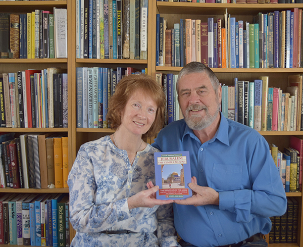
Our Temple Mount guide book was published in 2016

My work has also brought many rewards for our family life. When our children were young, I was often able to take them on digs and give them memorable experiences that they still talk about today. When they were older, they helped me at times with photography, cartography, and illustration.

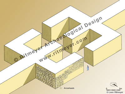
If you were to ask me what were some of the most exciting moments in my career, I would say they would be the making of major discoveries, such as the location of the Holy of Holies of Solomon’s Temple and the emplacement of the Ark of the Covenant, and the identification of the Middle Gate mentioned in Jeremiah 39:3. The latter made it possible to relive, as it were, the destruction of Jerusalem by the Babylonians. Arrowheads found among the charred timber and ashes at the base of the tower point to a fierce battle around the city walls of Jerusalem in the time of Zedekiah. Our hands got black with soot—tragic evidence of the fall of Jerusalem.

And for those brave ‘wannabes’ who would like to follow my footsteps, all I would say is: listen to your heart, find an encouraging mentor, and watch how he/she does things on a site you love in the Land.  Make yourself as indispensable as possible and make reading the Word in the ruins your inspiration.

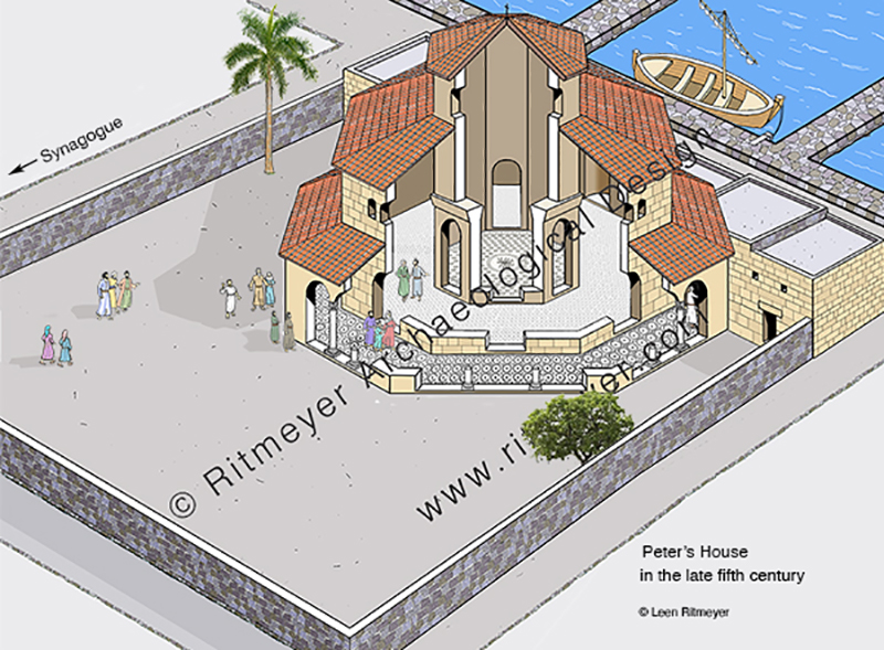
Capernaum’s octagonal church

from the domus ecclesia to memorial church

During the reign of Constantine the Great (306-337) and especially after his conversion in 312, Christianity spread rapidly in the Byzantine Empire and even more so in the Holy Land. After the visit in 326 AD by Queen Helena, Constantine’s mother, many Gentile pilgrims came to visit the Holy Land. Some remained and chose to live lives of seclusion in remote areas such as Sinai, around the Sea of Galilee, in the Judean Desert, and in Samaria, while others lived in towns and cities.

In the wake of this influx of pilgrims from the Byzantine Empire, the prominence of the domus ecclesia diminished and larger buildings became necessary to accommodate the many worshipers. Church buildings came into the ascendency, and their construction became the primary architectural focus during the later Byzantine period. Two kinds of churches developed: the basilica with its long hall, and the centrally designed (circular, octagonal, or hexagonal) memorial church. Basilicas were mainly used for communal worship, while the centrally designed churches commemorated special Biblical places or events.

During this time, the Gentile Christian population of Capernaum had increased dramatically and outnumbered the Jewish Christian members of the congregation. Radical changes were made to create a new Byzantine-style church inside the fourth century enclosure wall. 

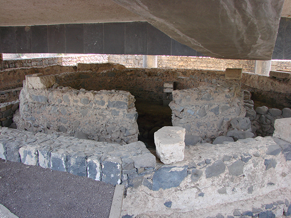
The basalt foundation stones of the octagonal church and some limestone blocks of the superstructre are visible beneath the concrete beams of the modern church. Photo: Leen Ritmeyer

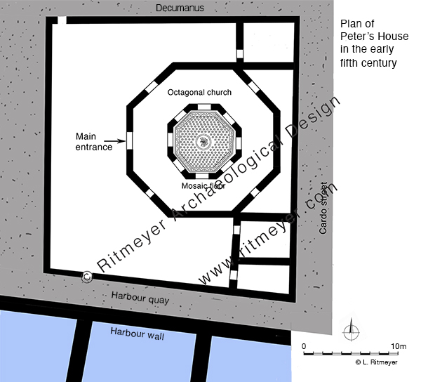
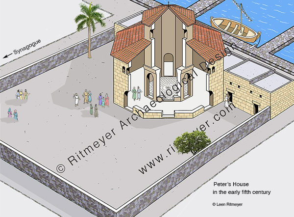
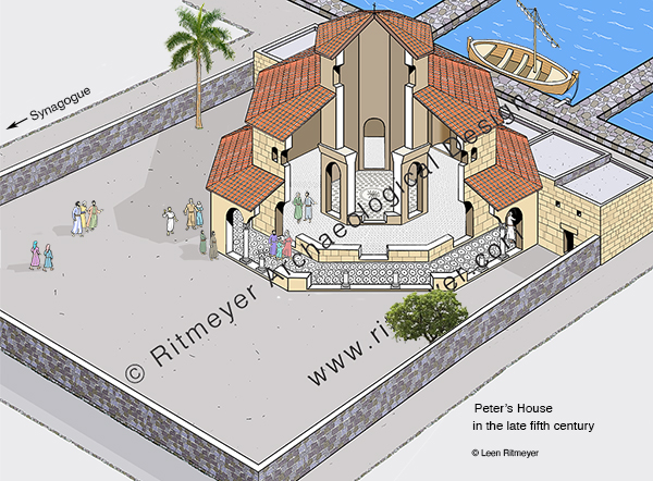
Substantial remains of the foundations of an octagonal church, that dated to the fifth century and was built with limestone blocks, were excavated in Capernaum. This limestone that came from the Arbel region could be carved easily and polished to a high degree. In the first half of the fifth century, the buildings that stood inside the enclosure were demolished and covered over. Instead of the domus ecclesia with its explosion of colour of the fourth century, a new and monumental was built in its place.

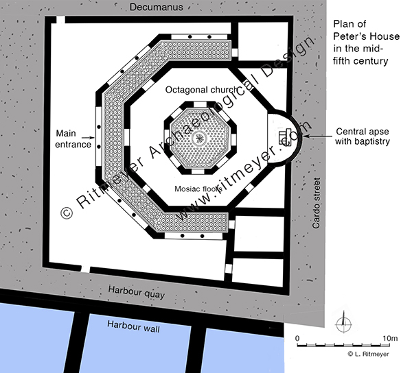
The walls of the inner octagon, which measured 7.9 m (26 feet) across, were built on the basalt foundations of the domus ecclesia and then another octagon, measuring 16.53 m (54.2 feet) across was added around it to complete the first phase of the new church. The church was paved with mosaics. The centre of the inner mosaic has a medallion with a peacock design, apparently symbolising immortality to the early Christians. Annexes were built to the west of the church and in the northeast and southeast corners of the square enclosure.

Sometime in the second half of the fifth century, a partial octagonal porch was added on the north, west and south, and an apse containing a baptistry on the east. This apse was constructed on the other side of the east wall of the enclosure.

The baptistry had steps leading down to it, indicating that adult baptism by immersion was practised in the fifth century.

After the Islamic invasion of 638 AD, Capernaum was abandoned and the church and synagogue, that had existed side by side, fell into ruin. After the earthquake that hit Galilee in 749 AD, Arab inhabitants began to systematically rob the buildings of their stones, leaving precious little for future archaeologists to investigate.

In 1866, Captain Charles Wilson exposed some foundations of the synagogue, with the unfortunate consequence that local people began to dig deep into the ground near the synagogue and near the church to find more limestone blocks which they either sold as building material or burned into lime. Other contractors used the exposed ruins as a quarry. 

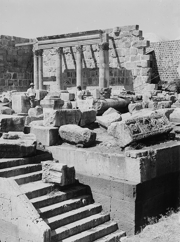
To stop this looting the Franciscan Custody of the Holy Land acquired the site in 1894 and exploratory excavations were conducted in 1905 by Heinrich Kohl and Carl Watzinger. Other excavations were conduction under leadership of F. V. Hinterkeuser and these continued until the outbreak of World war I, After the war, excavations were resumed by Gaudenzio Orfali until 1921. Orfali initiated the restoration of the Byzantine synagogue in 1922-1925.

The results of Orfalo’s restoration. Photo: Matson Collection.
In 1968, Virgilio Corbo and Stanislao Loffreda continued excavating Capernaum and conducted eighteen campaigns until 1985, and the restoration of the synagogue was continued by Corbo since 1969. It would have been great if similar efforts would have been put in the restoration of the Byzantine church, but unfortunately that won’t happen unless that new and incongruous UFO-like modern church that was built over Peter’s House (designed by the Italian architect Ildo Avetta and dedicated in 1990) would start its engines and fly off!

Nevertheless, it is thanks to the labours of the Franciscan Custody of the Holy Land that tourists and pilgrims can visit Capernaum again and see the place that was made famous when Jesus chose it as his hometown.

Capernaum

The town where Jesus chose to live

After Jerusalem, Capernaum is the site most visited by Christian pilgrims and tourists. Their main interest is to see the place where Jesus made his home after his words were rejected in his hometown of Nazareth (Luke 4:16-30).

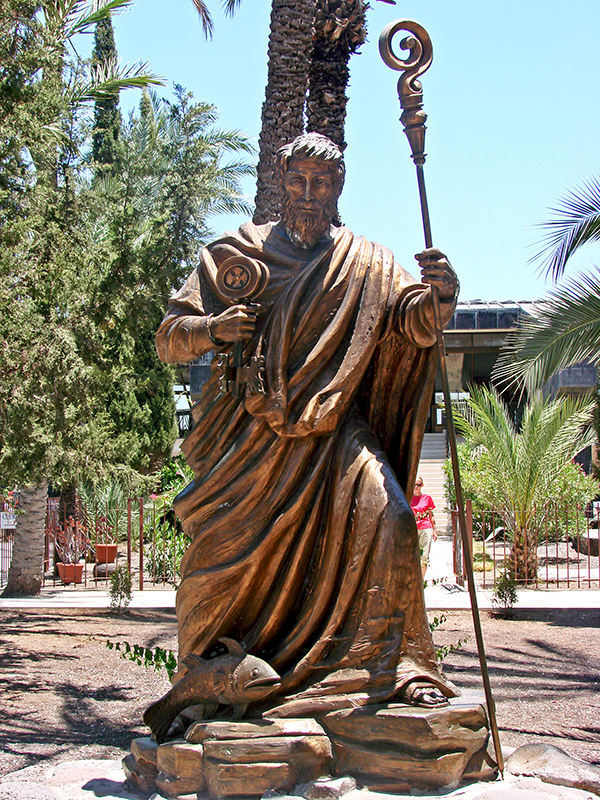
A statue of Peter at the entrance of the Franciscan archaeological site of Capernaum

The fulfilment of the prophecy of Isaiah 9:2: “The people who walked in darkness have seen a great light; those who dwelt in a land of deep darkness, on them has light shone”, required that Jesus would move from Nazareth to Capernaum. In the days of Isaiah that great light was Hezekiah, the son of Ahaz, but this prophecy ultimately referred to the future Messiah. Matthew 4:13-17, confirms Isaiah’s prophecy as the main reason why Jesus made Capernaum his home: “And leaving Nazareth he went and lived in Capernaum by the sea, in the territory of Zebulun and Naphtali, so that what was spoken by the prophet Isaiah might be fulfilled: “The land of Zebulun and the land of Naphtali, the way of the sea, beyond the Jordan, Galilee of the Gentiles – the people dwelling in darkness have seen a great light, and for those dwelling in the region and shadow of death, on them a light has dawned.”

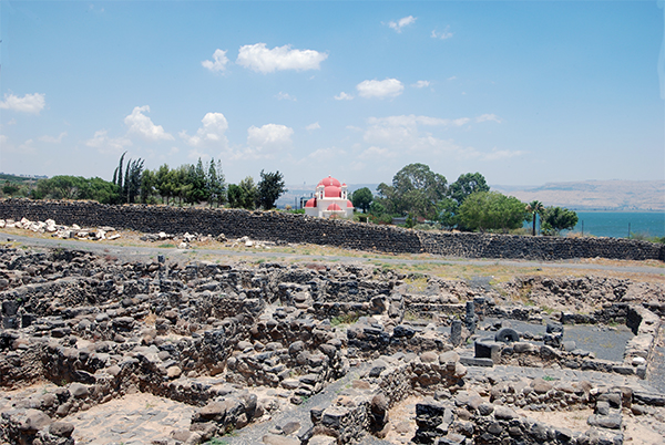
Capernaum is located in a basalt region and the darkness mentioned in this Scripture is perhaps reflected by the dark basalt stones of which all the buildings were made. 

The houses of Capernaum, as seen in the foreground, were built of dark basalt stones. The building with the red domes in the background is the Greek Orthodox Church.

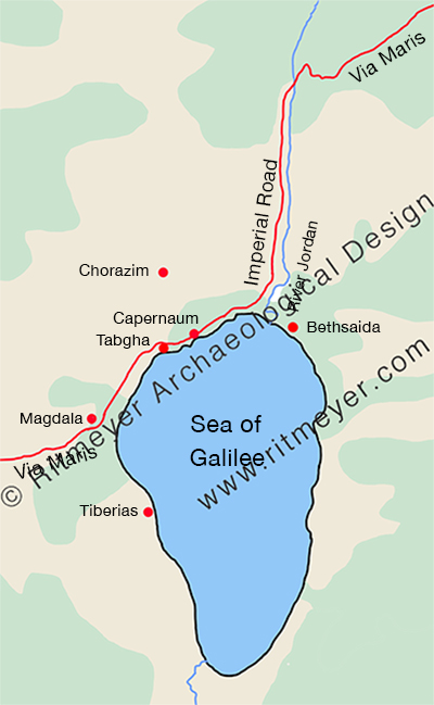
Jesus would, of course, have known beforehand that he couldn’t stay in Nazareth, for it was not located in Galilee of the Gentiles, nor on the Way of the Sea (aka the Via Maris). Bethsaida, for example, was by the sea, but not in the region of Zebulun and Naphtali, and Chorazin (or Chorazim) was not by the sea. Only Capernaum met Isaiah’s criteria. Capernaum wraps around the northwest shore of the Sea of Galilee and was located on Via Maris, the major trade route between Syria and Egypt. Jesus’ move from Nazareth to Capernaum was not a retreat into remoteness but a deliberate move into a more diverse region where his message and impact could have a wider and more receptive audience. It was nothing less than a move from the shadows to the spotlight. Capernaum was engaged with the world, via the International Highway and the Imperial Road. 

The Via Maris was the major trade route between Egypt in the south, and Syria with Mesopotamia in the northeast. Part of the Via Maris, namely the imperial road, ran west through Capernaum and then northwest and north along the west side of the Jordan River to the nearest crossing point where it joined the Via Maris again.

This major highway was used by many traders, who, apart from buying and selling, also exchanged items of news. By living on the Via Maris, Jesus could be assured that what he did and said would be carried far and wide to the larger audience for whom his message was intended. This explains how, according to Matthew 4:24, the fame of Jesus “spread throughout all Syria, and they brought him all the sick, those afflicted with various diseases and pains.” Jesus himself, as far as we know, never went to Syria, but the traders would have told the people they met all about him and the wonderful works he did.

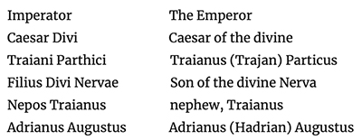
This milestone from the time of Hadrian (2nd century AD) was found in Capernaum, indicating that this town was located on the Via Maris.

The inscription reads:

So, what do we know about Capernaum? Excavations by Franciscan archaeologists have revealed that Capernaum was established in the 2nd century BC and abandoned in the 11th century AD. We are going to examine what the major developments of Capernaum were and specially that of Peter’s House.

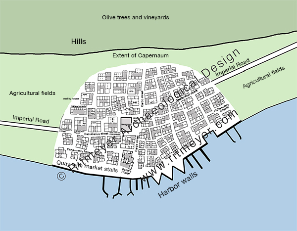
Capernaum was much larger than the excavated area and originally stretched for 300m along the shore and measures about 200m from north to south. The village was probably divided into 4 quarters by the main north-south running Cardo and east-west going Decumanus, with two sections of fishermen’s houses situated on either side of the southern part of the Cardo, close to the sea and harbour, while wealthier houses, such as the ones belonging to the centurion, the ruler of the synagogue and the tax collector, were probably located closer to the hills, away from the harbour and nearer the Decumanus.

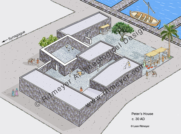
The House of Peter where Jesus may have stayed was located west of the Cardo, in between the synagogue (see also here) and the harbour.

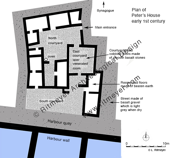
Peter’s House consisted of ten rooms built around three courtyards. Most of the domestic activities took place in the northern courtyard. Animals were kept in the courtyard to the east, and the southern courtyard, which was next to the harbour, was presumably used for fishing activities such as mending nets, selling fish and other activities. Later in the century, the east courtyard was used as a place for religious gatherings.

In this reconstruction drawing we imagine Peter’s boat moored alongside his house. In the courtyard we see two men under an awning mending their nets, and ask ourselves if Jesus perhaps did help Peter sometimes with the mending of the nets? Women are preparing food and baking it in an oven, and there was a stall where fish was sold. On the roof are two stands for the drying of fish.

Capernaum, Kfar Nachum in Hebrew, means the Village of Comfort. Jesus brought comfort to people that suffered from all sorts of diseases, to people that were politically and militarily oppressed by the Romans, to people that wanted to hear the Gospel of the Kingdom of God, but received no spiritual comfort from their Jewish leaders. 

Making Capernaum his home, was also a comfort for Jesus. The son of man had not “where to lay his head.” He was often like David in the wilderness, finding rest wherever he could. The story of the healing of Peter’s mother-in-law, who after she was healed “rose and ministered to them” gives the idea that when he was in Capernaum, he probably stayed in one of the rooms in Peter’s house. It shows that Jesus loved being with his friends. We all need friends and so did Jesus.

Over the next few centuries, the House of Peter developed into a church building, which will be the subject of a subsequent post.

The Synagogue of Capernaum

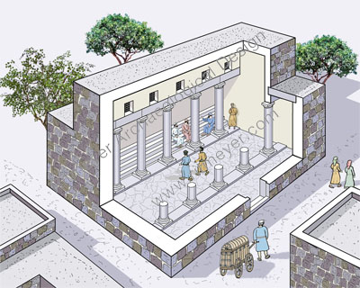
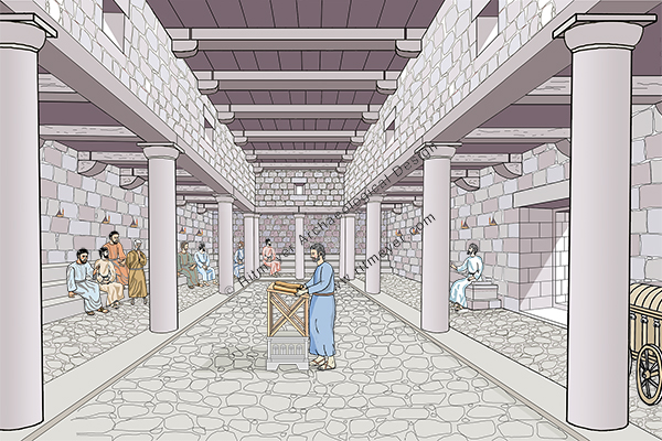
A reconstruction of the synagogue’s interior

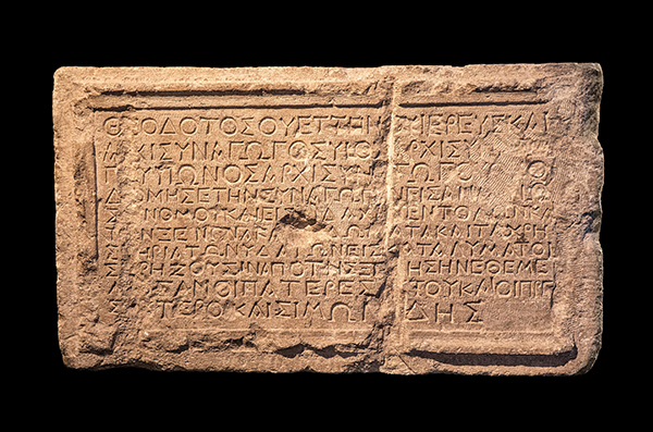
Apart from the first century Synagogue of Capernaum, the only other known synagogues from this period were found at Masada, Herodium, Gamla and Magdala. In Jerusalem, the  Theodotus Synagogue inscription, dating from the same time, was found, but no remains of the actual synagogue have been found. 

The inscription reads: “Theodotos son of Vettenus, priest and head of the synagogue (archisynagōgos), son of a head of the synagogue, and grandson of a head of the synagogue, built the synagogue (synagogē) for the reading of the law [nómou] and for the teaching of the commandments [didachín entolón], as well as the guest room, the chambers, and the water fittings as an inn for those in need from abroad, the synagogue which his fathers founded with the elders and Simonides.” (Wikipedia, photo: Andrey Zeigarnik)

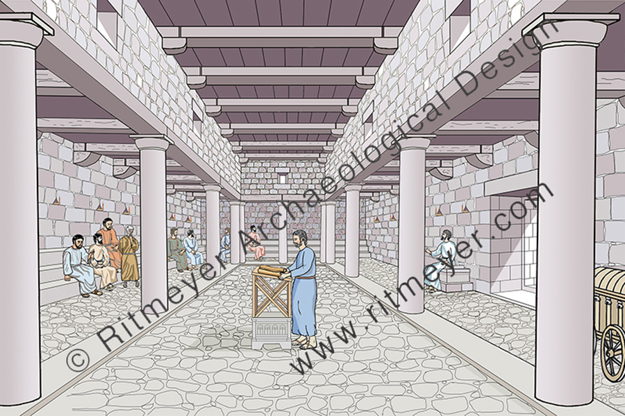
We know that the Synagogue of Capernaum served as a place for the reading of the Torah and its study. But, what did the interior of the Capernaum Synagogue look like and how did the synagogue operate? In Luke 4:16-22 we read that in the synagogue of Nazareth, Jesus first stood up to read, and then sat down to teach. The question is, where did the reader stand and where did the teacher sit?

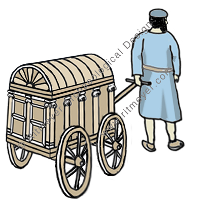
The 1st century Synagogue of Capernaum where Jesus preached. In the foreground we see the ruler of the synagogue bringing the Torah Scrolls in a chest on wheels, called the Ark of the Covenant.

In a previous post, we have seen that in Capernaum the Torah Scrolls were transported in a wheeled carriage from the home of the ruler of the synagogue (archisynagogas) to the synagogue. These scrolls were apparently kept in the home of the ruler of the synagogue for security reasons.

The Torah Scrolls were transported in a wheeled carriage from the home of the ruler of the synagogue to the synagogue in Capernaum. The carriage has a panelled double door, Ionic pillars on the side as in a Greek temple and a convex roof.

The Law of Moses was first read, and then expounded on from Moses’ Seat, for in Acts 15:21, it says “For Moses has had throughout many generations those who preach him in every city, being read in the synagogues every Sabbath”.  And in Matt. 23:2,3 Jesus said, “The scribes and the Pharisees sit in Moses’ seat. Therefore whatever they tell you to observe, that observe and do, but do not do according to their works; for they say, and do not do”.

We have tried to put this information in a new reconstruction drawing of the interior of the Capernaum Synagogue. Opposite the entrance in the east wall, we see people sitting on stone benches, placed along three sides of the room. 

In the centre of the hall is a reading platform, consisting of a decorated square stone on which a wooden lectern stands. This reconstruction is based on a similar stone that was found in the nearby synagogue of Magdala. 

The reader read from the scroll that was brought into the synagogue in the wheeled carriage, which was placed at the left side of the entrance. The ruler of the synagogue took the relevant scroll out of the carriage and placed it on the lectern. On the right side of the entrance is a stone seat, called Moses’ Seat, where the teacher sat. Such seats have been found in the synagogues of Chorazin and Tiberias. 

Jewish worship consisted initially mainly of prayers and the reading of the Law. This worship later developed into a full-blown service. The order of the services in the synagogue was as follows: 
(1) Reciting the Shema (Deut. 6:4-9; 11:13-21; Num. 15:37-41)
(2) Prayer 
(3) Reading the law
(4) Reading the prophets
(5) Discourse by anyone who desired to speak (Acts 13:15)
(6) the Benediction.
The order of the traditional Christian service is based on this Jewish one.

Apart from teaching in the synagogue, Jesus also performed miracles there, such as the healing of the man was there whose right hand was withered (Luke 6:6 – 10, Matthew 12:9 – 13, Mark 3:1 – 5), the man with an unclean (demonic) spirit (Mark 1:21-25), and perhaps also the woman who had a spirit of infirmity eighteen years, and was bent over and could in no way raise herself up (Luke 13:11-14). Jesus did these signs, not only to prove that he was the promised Messiah, but also to show the deeper significance of the Sabbath day as an example of the promised Sabbath rest for the people of God (Heb. 4:8-10).

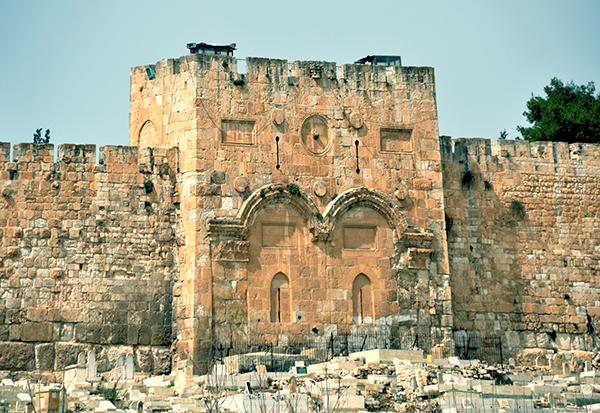
The Golden Gate of the Temple Mount in Jerusalem

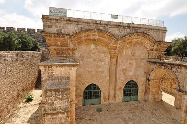
The interior of the Golden Gate in the 1970’s

The Golden Gate is very much in the news today, as it has become a point of conflict between Jews and Muslims, or Palestinians and Israelis.

But what do we know about this gate?

The Golden Gate, around which swirl various traditions, is the most intriguing of all the gates of the Temple Mount. In Jewish tradition, it is through this gate (Sha’ar haRachamim—Gate of Mercy), blocked since the ninth century, that Messiah will enter at the end of days, led in by the prophet Elijah. This is based on the prophecy of Ezekiel 44.1–3. Christians believe that Christ made his triumphal entry into Jerusalem (recorded in all four of the gospels) through this gate on the Sunday before his crucifixion (Palm Sunday). By riding on a donkey, he fulfilled the messianic prophecy recorded in Zechariah 9.9. Muslims refer to it as the Gate of Eternity (Bab-al-Dahariyeh) and believe it will be an important part of the last judgment of mankind. The Muslim cemetery along the Eastern Wall is thought to have been placed there in the belief that the forerunner of Messiah, Elijah, being of a priestly family, could not pass through the Golden Gate, thus preventing the coming of the Messiah.  

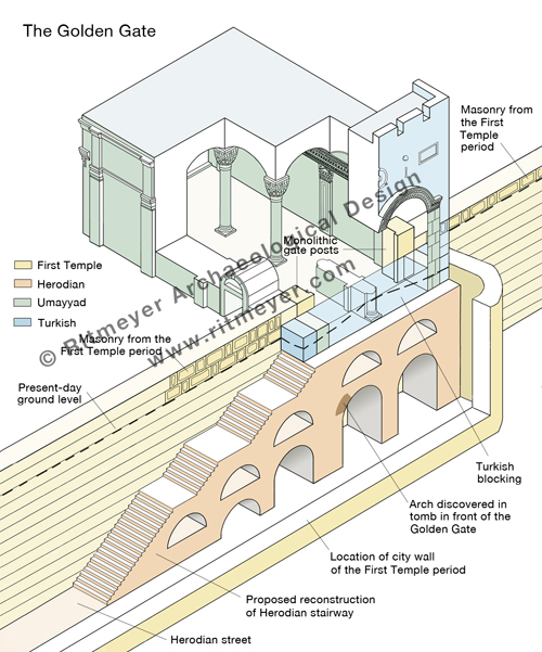
Some claim that the Golden Gate was built by the Byzantine emperor Heraclius after the expulsion of the Sassanians from Jerusalem. However, the absence in the architectural decorations of any Christian symbols, such as a cross makes that difficult to believe. There are actually four distinct historical phases represented in the architecture of this gate: Turkish, Umayyad, Herodian and First Temple period. In the 1970’s I was privileged to spend one week inside this gate, measuring and recording its plan and drawing accurate elevations of all the interior surfaces.

Standing in the middle of the Golden Gate interior. Two monolithic massive gateposts are visible in the far corners.

The Golden Gate’s outer façade is composed of two blocked-up gateways adorned with intricately carved relief arches. The decoration of the arches to the front and back of the gate are identical to the applied arches of the Double Gate which date from the Early Islamic period. The gate appears therefore to have been rebuilt in the Umayyad period, on the foundations of an earlier gate.

The exterior of the Golden Gate in the Eastern Wall of the Temple Mount in Jerusalem. Photo: Leen Ritmeyer

View of the Golden Gate from inside the Temple Mount. Photo: Nathaniel Ritmeyer

The remains of two massive monolithic gateposts are preserved inside this gate.

Section through the Golden Gate looking north, showing the massive monolithic gatepost. © Leen Ritmeyer

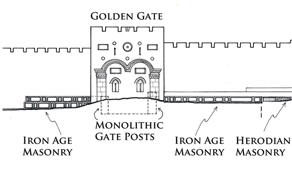
The gateposts are set in the same line as the Eastern Wall of the Temple Mount and line up with the massive masonry that can be seen on either side of the Golden Gate.

Elevation of the Golden Gate showing the location of the two monolithic gateposts in relation to the masonry of the First Temple period (Iron Age) in the Eastern Wall of the Temple `Mount. © Leen Ritmeyer

The gateposts and the two masonry sections appear therefore to be part of the same construction. The top of the southern gatepost is level with the top of the ancient masonry that can be seen south of the Golden Gate. The northern gatepost is one stone course higher and is located only one stone course below the surface of the Temple Mount. This means that the top of the original lintel would have been identical with the present-day level of the Temple Mount. The two gateposts belong to a gate that dates from the First Temple period and is most likely the Shushan Gate, mentioned in Mishnah Middot 1.3 as the only gate in the Eastern Wall.

This composite drawing shows the four historical phases of the Golden Gate. © Leen Ritmeyer

The gate most probably was given this name by builders who had returned from exile in Babylon and for whom the Palace of Shushan lived on in their memories. However, if so there would have been a tradition of an eastern gate in this location from the time of the construction of the original Eastern Wall. It seems reasonable to suggest that the central section of the Eastern Wall dates from the First Temple period, in particular to the time of King Hezekiah. This square mount was extended south in the Hasmonean period, while both the southern and northern additions were made by King Herod the Great.

In 1969, the remains of an underground arch were discovered inside a grave in front of the Golden Gate. It was suggested that this may have been a pre-Herodian gateway. However, as the arch stones appear to be Herodian, it is more reasonable to suggest that this arch was part of a Herodian staircase leading up to the original gate. It is fascinating to contemplate that the stairway may still be intact under this gate, although hidden from sight by the Muslim Cemetery. 

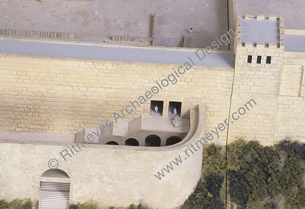
This model shows the Shushan Gate in the Eastern Wall of the Temple Mount and the stairway leading down to the Miphkad Gate. © Leen Ritmeyer

We do know that the remains of an ancient city wall lie under the present-day path that runs through the Muslim cemetery, which was discovered by Warren in the 1860s. The above-mentioned arched stairway led down through a gate in this city wall, the so-called Miphkad (Muster, or Inspection) Gate mentioned in Nehemiah 3.31, apparently still in use in the Second Temple period. During the latter period, it was through these gates that the Red Heifer was led out from the Temple Mount to the Mount of Olives (Mishnah, Parah). On the Day of Atonement, the scapegoat was led by the same route into the wilderness (Mishnah, Yoma).

It is therefore obvious that the Golden Gate is a very important historical building for the Jewish people, as reported by Arnon Segal of the Hebrew newspaper Makor Rishon Here is a translation of the article that refers to my research:

HT: Dr. Eli David


Secrets of the Temple Mount

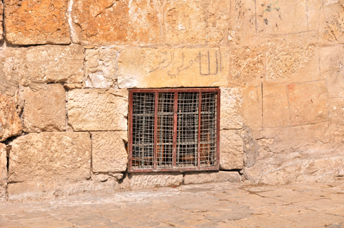
Although visiting the Temple Mount is not always a pleasant experience these days, it is still worth the attempt. We have had good feedback from visitors who have used our guidebook to find things which otherwise they would have missed. One of the little known secrets described in our book (which can be purchased here) is a small window near the northwest corner of the Temple Mount. Despite its apparent insignificance, it has a large story to tell.

The “Window of John of Gischala”

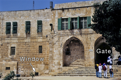
While walking on the Temple Mount platform, this opening, covered with a protective grille, can be found low down on the left-hand side, just before one reaches the northernmost gate in the Western Wall, the Bab el-Ghawanima Gate.

The “Window of John of Gischala” is located to the left (south) of the Bab el-Ghawanima gate at the northwest corner of the Temple Mount. Photo: © Leen Ritmeyer

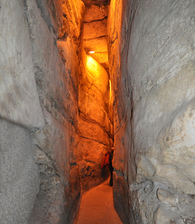
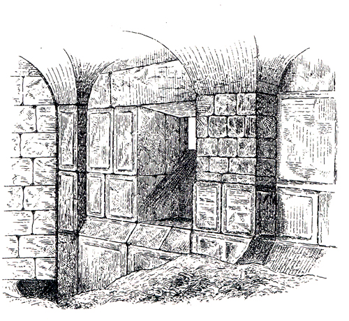
This window was already noticed by Charles Warren in the 1860s. On the inside is a little room where this opening, flanked by two pilasters, which appear to be late Herodian in style, can be seen. From here, in the Second Temple period, one could have entered the Rock-hewn Aqueduct, which can now be seen at the end of the Western Wall Tunnel.
The Rock-hewn Aqueduct of the First Temple period can be seen at the end of the Western Wall Tunnel. Photo: Leen Ritmeyer

This is what Charles Warren wrote about this discovery:

“Through the roof of the aqueduct Lieutenant Conder gained access into a small modern chamber, built against the Sanctuary wall, just north of the Bab es Serai; and here he found part of a wall of large drafted stones, with a plinth course and two pilasters, like those in the Haram Hebron. The space between the pilasters was occupied by a window, or opening into the Sanctuary, which seems to be ancient, as the lintel and jambs are of large ashlar – the former drafted.” Warren, Ch. and C. R. Conder (1884). Survey of Western Palestine: Jerusalem (London), p. 213.

Inside view of the “Window of John of Gischala”. Through the hole in the ground at bottom left, Charles Warren reached this room from inside the Rock-hewn Aqueduct. The small window that was made between the two pilasters is therefore the only place through which the Rock-hewn Aqueduct could have been reached from the Temple Mount platform.

In the halcyon days of the 1970’s, when archaeologists from the Temple Mount Excavations were allowed to explore the hidden recesses of the platform, I was able to visit this space which had been turned into a room and look for these pilasters and the window. (In contrast with Warren, I accessed the room via the Muslim Quarter.) Although the pilasters had been painted over by the residents, the window overlooking the Temple Mount was still visible.

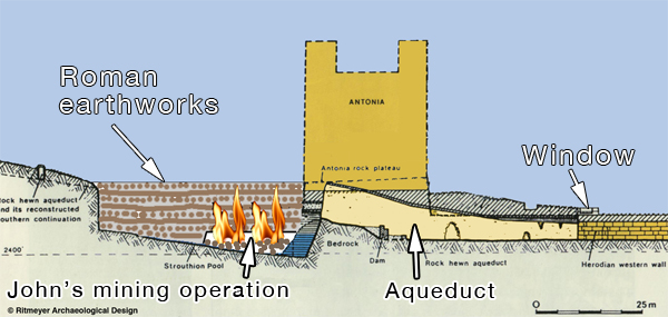
According to Josephus, the Roman siege of the Antonia Fortress in 70 A.D. was protracted, because of the destruction of the Roman earthworks by the Jews, under leadership of John of Gischala, who had barricaded himself inside the Temple Mount.  He used an underground passage to get into the water reservoir (the Strouthion Pool) and undermine and set the earthworks that were built in this pool on fire (War5.466-472). This underground passage could only have been reached through this window that has the appearance of being hacked through in order to gain access to the area below the Antonia Fortress (normally you don’t build windows between pilasters at such a low level). For this reason we have dubbed this window the “Window of John of Gischala”.

This section shows the window, aqueduct and Strouthion Pool. It clarifies how John could have penetrated the Strouthion Pool and set fire to the Roman earthworks. Drawing © Leen Ritmeyer

The drawing below is a reconstruction drawing of the northwest corner of the Temple Mount and the Antonia Fortress with the location of the  “Window of John of Gischala” indicated:

The Antonia Fortress that stood at the northwest corner of the Herodian Temple Mount had four towers, three of which were 50 cubits (86 ft./26.25 m) high and the fourth, the southeast tower, 70 cubits (120 ft./36.75 m) high. The view from this highest tower, that, according to Josephus “commanded a view of the whole area of the Temple” (War 5.242), must have been spectacular.
At the place where the northern and western porticoes met, there was a staircase leading up to the roof of the porticoes. At this place there was an entrance to the Antonia Fortress. The “Window of John of Gischala” is indicated at centre left.

It was because of such use of underground passageways by the Jews that Titus decided to build a siege wall around the city so that all communication with the country could be cut off and supplies interrupted. This resulted in a terrible famine and so the drama continued to its tragic end. This little window is one of those secret places on the Temple Mount where history echoes down the years.


Harbours of the Sea of Galilee

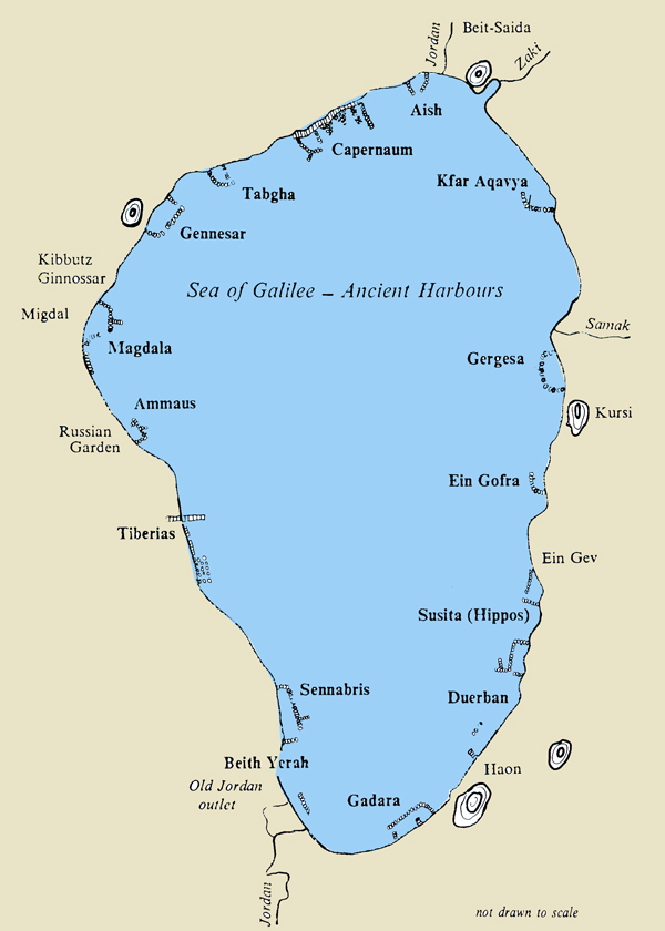
Ferrell Jenkins runs a travel blog and today wrote a post on the Ports of the Sea of Galilee which has some excellent photographs of the Church of the Primacy of Peter at Tabgha. In this interesting post he comments on the work of the late Mendel Nun, who was a member of Kibbutz Ein Gev and worked as a fisherman on the Sea of Galilee. Although not a professional archaeologist, Mendel researched and recorded the remains of the ancient harbours of the Sea of Galilee, of which there were at least sixteen.

The remains of these harbours can only be seen when the water level is low. In the 1970’s, a number of ancient harbours were discovered, followed by the discovery of an ancient fishing boat in the mud near Magdala. During the years of 1989-1991 there was a severe drought and the accompanying archaeological activities revealed many remains that shed light on the shipping trade and fishing industry during the first century.

Here is a map of the harbours that were plotted by Mendel:

A map of the Sea of Galilee showing the remains of ancient harbours.

The photograph below, taken in 2009, shows the remains of some of the piers of the Capernaum harbour:

Photo: Leen Ritmeyer

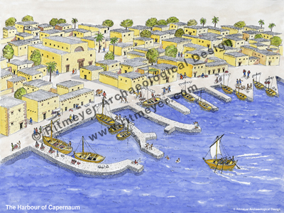
Mendel’s map and the photographs he published made it possible to make a reconstruction drawing of Capernaum and its ancient harbour:

Reconstruction of the harbour of Capernaum at the time of Christ, based on archaeological remains. Several piers, which can still be seen when the water level is low, jutted out into the sea to provide a quiet and safe harbor for fishing boats. Capernaum was the city where Jesus lived after he left Nazareth (Matthew 4.13; Mark 2.1; Luke 4.31; John 2.12).

The Temple Mount during the time of King Hezekiah

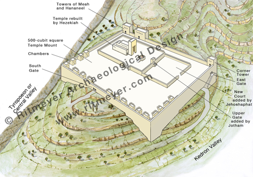
The next drawing in our series dealing with the development of Mount Moriah and the Temple Mount shows what it would have looked like in the time of the later kings of Judah.

This drawing shows the Temple Mount that was built by King Hezekiah. The Temple itself was completely rebuilt and a large square platform built around the original Solomon’s Temple. It appears that Solomon’s palace complex must have been dismantled to make way for the new platform.

The first and original drawing showed what the mount looked like before anything was built on it. The next one showed Mount Moriah during the time of the Jebusites. This was followed by a drawing of Solomon’s Temple complex.

From the Hebrew Bible we know that Hezekiah (725–697 BC) was a good king, but he lived in difficult times. The Assyrians under Sennacherib had invaded the northern part of the country and many refugees had fled to Jerusalem and settled on the Western Hill of Jerusalem, as the Eastern Hill was already bursting at the seams.

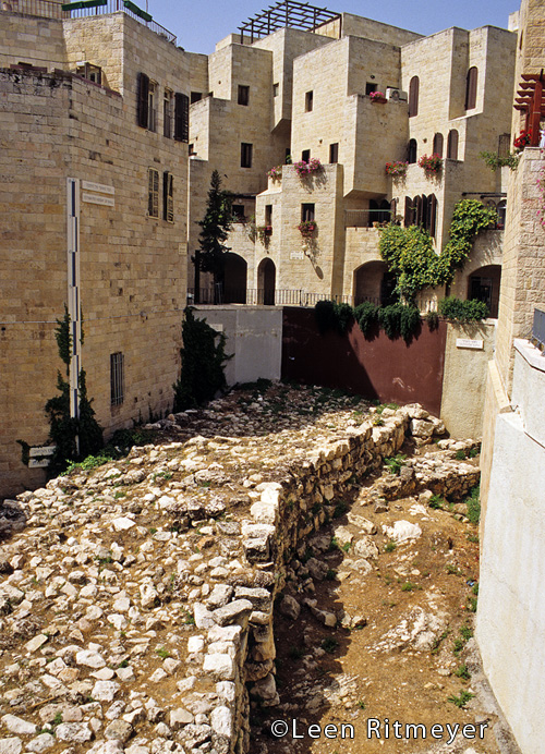
Archaeology has given us a great insight into the kingship of Hezekiah, and has shown that he was one of the greatest builders Jerusalem has ever seen. In the Jewish Quarter of the Old City of Jerusalem one can visit the Broad Wall (mentioned later on in Nehemiah 12.38) that was built by Hezekiah to protect the new settlement. The excavations have shown that some houses had been dismantled to make room for this massive 7m (23ft) wide wall that encircled the Western Hill. This building work is mentioned in Isaiah 22.10, “you counted the houses of Jerusalem, and you broke down the houses to fortify the wall.”

The Broad Wall in the Jewish Quarter of the Old City of Jerusalem. Photo: © Leen Ritmeyer

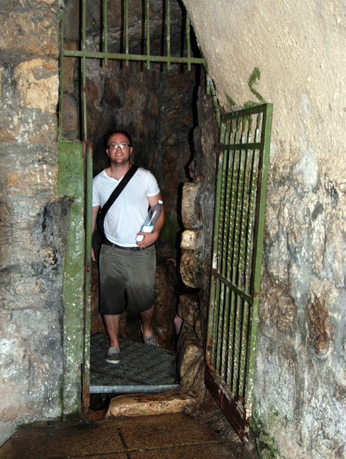
Another great work mentioned in Isa. 22.11 is the construction of Hezekiah’s Tunnel. Hezekiah diverted the waters from the Gihon Spring and “sent” them through an underground tunnel to the Siloam Pool (Siloam – shiloah in Hebrew – means “sent”). One of the most exciting experiences one can have in Jerusalem is to walk through this ancient tunnel.

Ben Ritmeyer leaving Hezekiah’s Tunnel.

In the Herodian period, the Siloam Reservoir had steps leading down to the water. Here we see the pool filled with rain water.

Hezekiah also embarked on a major rebuilding program of the Temple, as reflected in the second and later account of the Temple construction in 2 Chronicles 3–4. We believe that this text describes a virtually new and much larger Temple built by Hezekiah.

In this passage, the two columns of the Porch are described as being 35 cubits high in contrast to a height of 18 cubits mentioned in 1 Kings 7. Instead of the three-story-high wooden construction that was built around Solomon’s Temple, there is now an Upper Chamber above the original sanctuary. Other differences between the two descriptions show that Hezekiah not only rebuilt Solomon’s Temple, but also redesigned it. Nevertheless, this Temple is still referred to as the First Temple that was destroyed by the Babylonians in 586 BC.

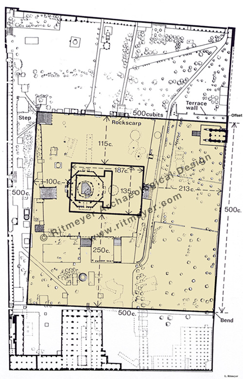
Map of the Temple Mount today, showing the location of the square platform built by King Hezekiah.

har habbayit. This measurement of 500 cubits has been preserved in the text of Mishnah Middot  2.1: “The Temple Mount (har habbayit) measured five hundred cubits by five hundred cubits.”

The Story of the Ritmeyer Image Library

Having recently updated our Image Library with about 40 new illustrations, we have received enquiries as to how this online resource came into being. As its creation was a process that took many years, you may be interested to read its story. We were privileged to live in Israel for a long time, so most of the images come from the Land. However, in recent years, we have managed somewhat to break the exclusive hold that Israel has on us and branch out into the surrounding Bible Lands.

What is unique about these images is the fact that most of them are reconstruction drawings. Most picture libraries are just that – pictures of sites. But when you are faced with the challenge of giving a talk on a Bible subject, you don’t just want to show a picture of ruins. You want to give your listeners an insight into the past by building up the stones into a structure where you can imagine Biblical events taking place. The same goes for picture editors looking for illustrations to help readers visualise how sites looked in antiquity.

We may take the idea of reconstruction drawings for granted today, but going back to the heady days after the 6-Day War, when there was an explosion of archaeological excavations, particularly in Jerusalem, there were very few around. Many archaeologists adopted a cautious, purist approach and found it a bit “risky” to take decisions as to a building’s original appearance. My foray into making reconstruction drawings stemmed from the experience of giving tours on the Temple Mount dig, whilst working on the site as surveyor. I used to try explaining features like Robinson’s Arch, the arched staircase that led up to the Temple Mount from the Western Wall street in the time of Christ, with my hands and feet. From questions I got asked afterwards, I realised that not everybody had “got it”!

Robinson’s Arch is the southernmost entrance in the Western Wall of the Temple Mount in Jerusalem. The arch is named after its discoverer, Edward Robinson. The arch supported a monumental stairway that led up from the main street in the Tyropoeon Valley and entered the Royal Stoa through a gateway.

Thus, my first reconstruction drawing of Robinson’s Arch and a career as an archaeological architect was born. It was all based on study drawings of the known elements, comparative architecture and research into the historical sources. Seeing peoples faces change from incomprehension to clear understanding sold me on the vital need for such drawings. I was blessed that the late Prof. Benjamin Mazar, who directed the dig, agreed and could not have been more encouraging.

As there were few others at the time making reconstructions (now it is a recognised field), I was asked to visit many sites to help visualise the original structures. Talk about “going over the cities of Israel!” These digs ranged from Ai, Beersheba and Dan to Shechem, Shiloh and Timnath of the Philistines.

I learnt much from the older school of archaeologists, such as the afore-mentioned Professor Mazar, who kept a copy of the Taanach, or Hebrew Bible on his desk, consulting it daily and calling it “our history book!” And Mendel Nun, a resident of Kibbutz Ein Gev on the Sea of Galilee (who died recently at the age of 92) did so much research into methods of fishing on the lake in ancient times, that I was able to make a drawing of the harbour of Capernaum in the time of Christ.

The harbour of Capernaum at the time of Christ. Several of its piers can still be seen today when the water level is low.

However, it was Jerusalem that was always the centre of my endeavours and I was also involved in the other two major digs that took place in the city, namely the Jewish Quarter Excavations and the Excavations in the City of David. Included in the Image Library is a picture from the former dig, directed by Prof. Nachman Avigad, of a building originally identified as part of an Israelite tower. However, as the dig expanded, it became clear that it could not have been a tower as one side was missing! One day, after returning from working on the summer season at the site of Timnath of the Philistines, I realised, from my experience of digging a gate of this period in Timnath, that we were looking at a similar structure here in the Jewish Quarter. From its location in the upper city, it became clear that it should, in fact, be identified as the Middle Gate of Jeremiah 39.3. Arrowheads found close to the site revealed the destruction of the city in the time of Zedekiah. Our hands got black with soot – tragic evidence of the fall of Jerusalem.

The Middle Gate (Jeremiah 39.3) where the Babylonian princes came together to celebrate their conquest of Jerusalem.

We left Israel during the First Intifada, as heightened security made it virtually impossible to work on many of the sites I was involved in in the West Bank. Having moved to the UK to do my Masters in Conservation Studies at the Institute of Advanced Architectural Studies of the University of York (another walled city), one of the projects I was asked to do was to design models of the Tabernacle, Solomon’s Temple and Herod’s Temple and Temple Mount for a Jewish philanthropist in Washington D.C. Photographs of these models, beautifully crafted by York Model Making, are included in the Image Library.

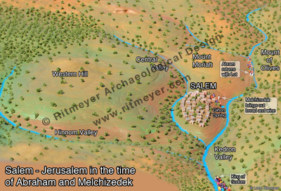
My Ph.D thesis entitled: “The Architectural Development of the Temple Mount in Jerusalem” (University of Manchester) necessitated the creation of many drawings to illustrate different aspects of this subject. And subsequently, during the years we lived in Australia, whilst teaching Hebrew and History at Heritage College Adelaide, I made models of Jerusalem in the different periods with some of my students. The process developed the students’ understanding of the city’s history immeasurably and resulted in models, some of which were unique in the history of model making, especially of the periods of Melchizedek and Nehemiah.

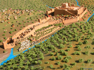
Jerusalem in the time of Melchizedek was located on the lower spur of the Eastern Hill of Jerusalem in the area later known as the City of David.

Jerusalem in the time of Nehemiah was located on the eastern Hill, to the west of the Kedron Valley.

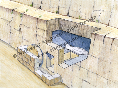
One aspect of our recent work with the ESV Study Bible required me to think about what the tomb of Jesus would have looked like, which brought about this brand new drawing.

The newly-hewn tomb where Jesus was buried belonged to Joseph of Arimathea. It had a rolling stone, confirming that he was a rich man.

And part of the project I did for the GLO Immersion Digital Bible involved making maps of all of Christ’s journeys. I have included in the Image Library this map of his last journey in Jerusalem. The traditional Via Dolorosa or Path of Sorrows was fixed by monks in Western Europe in the eighteenth century and a devotional procession along this route is still led by Franciscans every Friday. In fact, the streets upon which Jesus walked lie about 10 feet below the level of these thoroughfares. By contrast, this drawing called “The Way to Golgotha” is firmly based on Scriptural and archaeological evidence. This drawing is also available as a Bible Chart, which is one of our Photographic Posters that are individually designed and printed on A3 (297 × 420mm or 11.7 x 15.5 inch) size, high-quality, thick photo paper (paper weight 100 lb. or 270 g/m2).

Five stages in Christ’s last journey are shown on a reconstruction drawing of Jerusalem in 30 A.D.

A project that has added new drawings to the collection was the commissioning of artwork for Tyndale House Publishers Chronological Life Application Study Bible. These included reconstruction drawings of Jerusalem in the periods of David, Solomon, Hezekiah and the first century. See this recent post.

The Image Library also includes many photographs from a recent study tour of the Seven Churches of Revelation located in modern-day Turkey. Who knows, these may some day also be turned into reconstruction drawings! Tips for using the Image Library will hopefully be the subject of a future blog.


Music Festival at the home of the Ark of the Covenant in Kiryat Yearim

Kiryat Yearim is one of the most evocative Biblical sites in Israel and never more than during the Abu-Gosh Festival. Then, twice a year, at Succot and Shavuot, this Arab village in the Judean hills, where the Ark of the Covenant rested for 20 years (1Sam. 7:2) becomes the backdrop for Israel’s most important vocal music event.

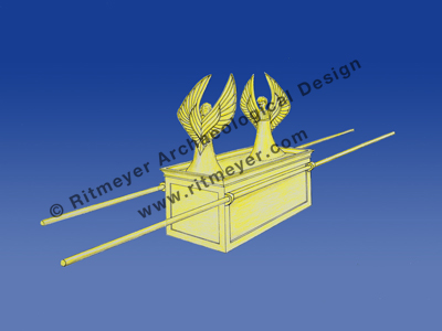
A representation of the Ark of the Covenant as described in Exodus 25.10-22. The Ark was a box made of shittim wood and overlaid with gold. It had a golden covering lid, called the mercy seat, out of which two cherubim were crafted. The two tablets of stone on which God had written the Ten Commandments were placed inside the Ark. The Ark was carried by two poles which were placed in rings fixed to the side of the Ark. © Leen Ritmeyer

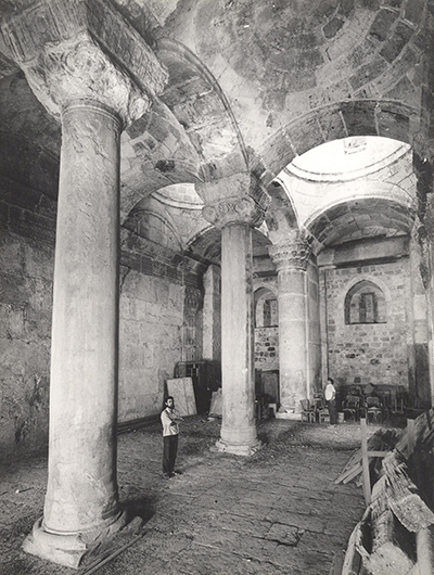
The 12th century Crusader church at the heart of the village and the church of Notre Dame de l’Arche de L’Alliance (Our Lady of the Ark of the Covenant) at the top of the hill are the main venues because of their remarkable acoustics.

A video showcasing the site and the event can be viewed here.

The programme of the upcoming 40th festival is here. This is a previous blog post on the festival.

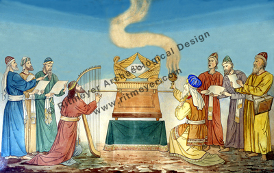
This painting hangs on the walls of the Church of Our Lady of the Ark of the Covenant at Kiriath Yearim in Israel. The Ark is in the centre of the painting with David playing on the harp to its left (2 Samuel 6). The High Priest with a censer of incense bows in reverence on the right. The memorial Name of God, Yahweh, is written between the two cherubim. © Ritmeyer Archaeological Design