I am guessing that some, if not all, of the readers of my blog may be interested to see the latest book[1] to which I had been asked to contribute.
The authors, Brandon Benzinger and Adam Day, are to be commended to have tackled the problem of finding jobs for graduates of Biblical and Theological Study programs. As fewer and fewer jobs are available to them, the editors understood that to get employment, these candidates must think outside the box.
They asked 25 people who have found satisfying jobs to share their experience of how they settled into their present occupation, the ways in which they have used their biblical training in that occupation, the “joys” and “trials” of their work, and advice for those who would like to follow in their footsteps.
The book is divided into four parts:
Part 1: Academia
Part 2: Publishing and Media
Part 3: Congregational Ministry
Part 4: Parachurch Ministry, Missions, and Public Service
I would love to have had this book available at the beginning of my career, rather than nearer the end of it.
Personally, I can’t wait to read the contributions of Steve Ortiz and Mark Wilson, who are closest to my field of work, but I think that I will be quite amazed how interesting I will find many of the characters whose professional dreams are portrayed here.
My chapter in Part 2 is called “Design and Illustration”, in which I set out the various roads I have followed and to see how biblical studies can be a springboard to not just one but possibly a few different careers.
It is interesting to note that those who show the highest level of satisfaction are those with supportive familes.
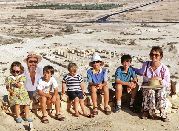
Personally, I am very thankful that my work has also brought me many joys, chiefly in that I have been able to share it with my wife Kathleen, a trained archaeologist. Her excellent writing and research skills have enabled us to produce books and various other educational materials that people still find useful today. When my family was young, I was often able to take them on digs and give them some memorable experience. When they were older, they helped me at times with photography, cartography, and illustration.
Our young family at the Tel Nitzana Excavations in the Negev on the border of the Sinai desert
And, of course, some of the most exciting moments in my career were the making of major discoveries, such as the placement of the ark of the covenant on the Temple Mount, the identification of the Middle Gate mentioned in Jeremiah 39:3, and the main gate of Sodom, where Lot sat (Gen. 19:1).
I warmly recommend this book to all those seeking alternative employment in this ever shrinking field.
[1] Brandon C. Benzinger and Adam W, Day, editors, What CanYou Do with Your Bible Training? Traditional and Nontraditional Vocational Paths, Resource Publications, Eugene OR, 2023.
The Golden Gate is very much in the news today, as it has become a point of conflict between Jews and Muslims, or Palestinians and Israelis.
But what do we know about this gate?
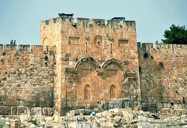
The Golden Gate, around which swirl various traditions, is the most intriguing of all the gates of the Temple Mount. In Jewish tradition, it is through this gate (Sha’ar haRachamim—Gate of Mercy), blocked since the ninth century, that Messiah will enter at the end of days, led in by the prophet Elijah. This is based on the prophecy of Ezekiel 44.1–3. Christians believe that Christ made his triumphal entry into Jerusalem (recorded in all four of the gospels) through this gate on the Sunday before his crucifixion (Palm Sunday). By riding on a donkey, he fulfilled the messianic prophecy recorded in Zechariah 9.9. Muslims refer to it as the Gate of Eternity (Bab-al-Dahariyeh) and believe it will be an important part of the last judgment of mankind. The Muslim cemetery along the Eastern Wall is thought to have been placed there in the belief that the forerunner of Messiah, Elijah, being of a priestly family, could not pass through the Golden Gate, thus preventing the coming of the Messiah.
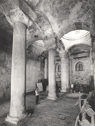
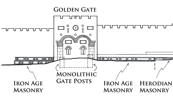
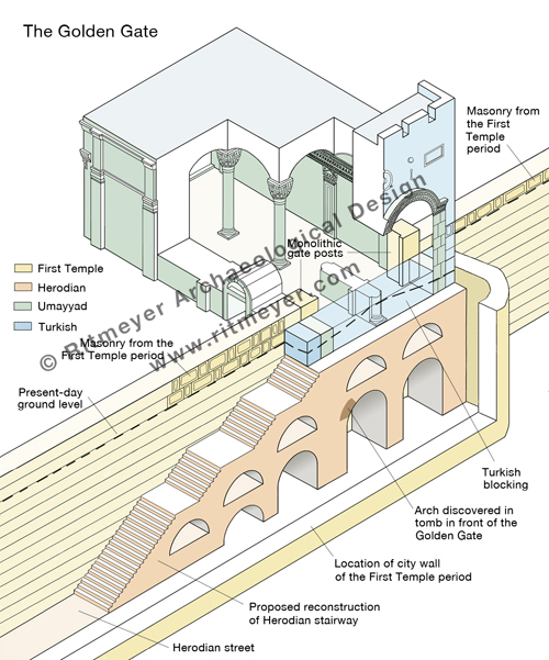
Some claim that the Golden Gate was built by the Byzantine emperor Heraclius after the expulsion of the Sassanians from Jerusalem. However, the absence in the architectural decorations of any Christian symbols, such as a cross makes that difficult to believe. There are actually four distinct historical phases represented in the architecture of this gate: Turkish, Umayyad, Herodian and First Temple period. In the 1970’s I was privileged to spend one week inside this gate, measuring and recording its plan and drawing accurate elevations of all the interior surfaces.
Standing in the middle of the Golden Gate interior. Two monolithic massive gateposts are visible in the far corners.
The Golden Gate’s outer façade is composed of two blocked-up gateways adorned with intricately carved relief arches. The decoration of the arches to the front and back of the gate are identical to the applied arches of the Double Gate which date from the Early Islamic period. The gate appears therefore to have been rebuilt in the Umayyad period, on the foundations of an earlier gate.
The exterior of the Golden Gate in the Eastern Wall of the Temple Mount in Jerusalem. Photo: Leen Ritmeyer
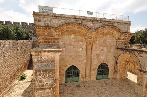
View of the Golden Gate from inside the Temple Mount. Photo: Nathaniel Ritmeyer
The remains of two massive monolithic gateposts are preserved inside this gate.
The gateposts are set in the same line as the Eastern Wall of the Temple Mount and line up with the massive masonry that can be seen on either side of the Golden Gate.
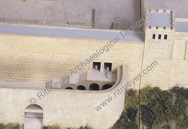
The gateposts and the two masonry sections appear therefore to be part of the same construction. The top of the southern gatepost is level with the top of the ancient masonry that can be seen south of the Golden Gate. The northern gatepost is one stone course higher and is located only one stone course below the surface of the Temple Mount. This means that the top of the original lintel would have been identical with the present-day level of the Temple Mount. The two gateposts belong to a gate that dates from the First Temple period and is most likely the Shushan Gate, mentioned in Mishnah Middot 1.3 as the only gate in the Eastern Wall.
The gate most probably was given this name by builders who had returned from exile in Babylon and for whom the Palace of Shushan lived on in their memories. However, if so there would have been a tradition of an eastern gate in this location from the time of the construction of the original Eastern Wall. It seems reasonable to suggest that the central section of the Eastern Wall dates from the First Temple period, in particular to the time of King Hezekiah. This square mount was extended south in the Hasmonean period, while both the southern and northern additions were made by King Herod the Great.
In 1969, the remains of an underground arch were discovered inside a grave in front of the Golden Gate. It was suggested that this may have been a pre-Herodian gateway. However, as the arch stones appear to be Herodian, it is more reasonable to suggest that this arch was part of a Herodian staircase leading up to the original gate. It is fascinating to contemplate that the stairway may still be intact under this gate, although hidden from sight by the Muslim Cemetery.
We do know that the remains of an ancient city wall lie under the present-day path that runs through the Muslim cemetery, which was discovered by Warren in the 1860s. The above-mentioned arched stairway led down through a gate in this city wall, the so-called Miphkad (Muster, or Inspection) Gate mentioned in Nehemiah 3.31, apparently still in use in the Second Temple period. During the latter period, it was through these gates that the Red Heifer was led out from the Temple Mount to the Mount of Olives (Mishnah, Parah). On the Day of Atonement, the scapegoat was led by the same route into the wilderness (Mishnah, Yoma).
It is therefore obvious that the Golden Gate is a very important historical building for the Jewish people, as reported by Arnon Segal of the Hebrew newspaper Makor Rishon Here is a translation of the article that refers to my research:
It has been reported, eg. here (Hebrew with pictures) and here, that remains of Jews who perished in the Great Revolt against the Romans and were discovered in Binyamin were secretly buried in Ofra.
The bones of Jews who perished in the Great Revolt by Jews against the Roman Empire, and which were discovered at an archaeological site near the community of Givat Assaf in the Binyamin region, were recently brought to burial secretly in Ofra.
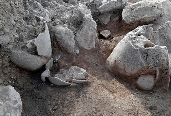
The remains were discovered in 2013 at the archaeological site, which is a Jewish village from the time of the Second Temple. Mikvahs, coins from the time of the Great Revolt and vessels made out of stone were discovered at the site.
The bones belonged to seven women and a boy who hid in a cave, and were killed by the Romans in 69 CE, one year before the destruction of the Second Temple.
The archaeological excavation in question is Kh. el-Maqatir and was carried out by the Associates for Biblical Research, headed by Dr. Scott Stripling and Dr. Bryant Wood. I served as architect of the Maqatir excavation.
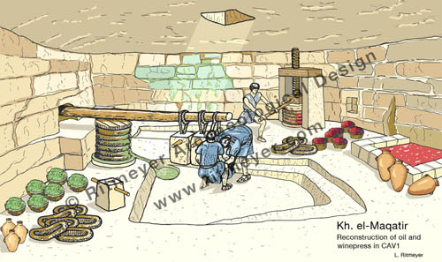
Five skeletons were found in a large cave that housed an oilpress and possibly also a winepress and three in a secret cave that led off from it.
An oilpress was discovered inside a cave at Kh. el-Maqatir. The olives were deposited through the hole in the ceiling and put in circular baskets. These were stacked and placed under a beam that was weighed down with stone weights. Nearby stood two upright stones that supported a screw press that may have been used for pressing grapes. The liquids were stored in the large vat at the right of the reconstruction drawing. Five skeletons were found here.
Todd Bolen of Bibleplaces.com has finished a new DVD photo project to illustrate the Life of Christ. Many Bible teachers and scholars alike would benefit from this collection as it uses a variety of photographs, both modern and historic, to illustrate virtually every verse in the Gospels.
The Israel HaYom Newsletter announced today that new 10 ancient storage jars have been found in a new excavation in Shiloh:
Excavation at ancient Shiloh seeks to locate site of Jewish tabernacle that dates to the time the Jewish people first arrived in the land of Israel • “This is a very exciting find,” says Archaeology Coordinator in the Civil Administration Hanania Hizmi.
Storage vessels unearthed in Shiloh. Photo credit: Shiloh Association
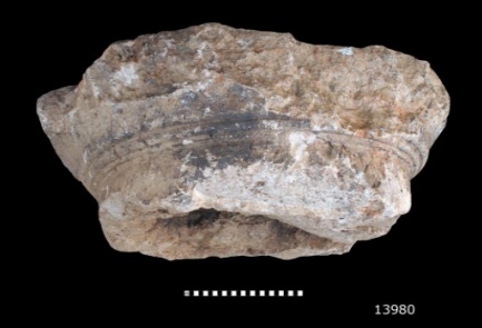
The Israel Hayom newspaper reported yesterday that a capital of the 2nd Temple era has been found by the Temple Mount Sifting Project (TMSP).
Photo credit: Vladimir Naychin
The capital of a carefully-adorned column that stood on the Temple Mount in the time of the Second Temple has been discovered through the Temple Mount Sifting Project.
The capital, whose size indicates that the column had a circumference of 75 centimeters (30 inches) at its top, is a section of one column that formed part of the double colonnade that surrounded the Temple Mount plaza.
Dr. Gabriel Barkay, the director of the Temple Mount Sifting Project, said that “this is a capital in the Doric style, one of the characteristics of the art in the time of the Hasmonean dynasty. This appears to be the capital of a column formed part of the eastern colonnade of the Temple Mount, which Josephus and even the New Testament called ‘Solomon’s Porch.’ A column like this is impressive testimony of the immensity of the structures on the Temple Mount in the Second Temple era, and fits in well with Josephus’ narrative, which describes what he saw with his own eyes.”
Barkay explained that a 25-cubit column would have stood 12.5 meters (41 feet) high.
It is of course wonderful news that a capital of a column that most likely stood on the Temple Mount was found. I would agree with Barkay that the capital could have belonged to one of the columns that formed the eastern Hasmonean (pre-Herodian) colonnade. This colonnade was indeed known as Solomon’s Porch, where Jesus walked during Hanukkah (John 10.23). It was also the place where Peter and John healed the blind man (Acts 3.11) and where the apostles did many signs (Acts 5.12).
One must, however, be careful with dimensions. In the article it says that the circumference of the Doric column that supported the capital was 75 cm. That is probably a mistake. According to simple mathematics, a column with a circumference of 75 cm (30 inches) has a diameter of less than 24cm (9 inches). In ancient architecture, Doric columns had a 1:8 ratio between diameter and height. According to that rule, this column could not have been higher than 2m (6 feet, 6 inches), which would not have been exactly monumental. Barkay therefore probably meant that the column had a diameter of 75cm. In that case, the column would have been about 6m (20 feet, 11.4 cubits) high. Barkay estimated that a 25-cubit column would have stood 12.5 meters (41 feet) high, but this one would have much smaller, about half the size.
An additional problem is the use of units of measurement by Josephus. In War, he uses cubits and in Antiquities (Roman) feet. As a rule, his measurements in feet are more accurate than those in cubits, which are often exaggerated.
Josephus writes in War 5.190-192, that the columns of the Herodian porticoes were 25 cubits, which according to the Royal Cubit of 52.5 cm (20.67 inches), would be 13.12m, (43 feet) high, but in Ant. 15.413 he says that the columns of the porticoes were 27 feet high (8.23m, 15.67 cubits). Let us first look at the 25 cubits high columns and then at those of 27 feet high.
According to the Doric ratio of diameter and height, the diameter of a 25 cubit high Doric column must have been 1.64m (5 feet, 5 inches). Archaeological remains of parts of such thick columns have been found in secondary use in the Temple Mount excavations in front of a gate of an Umayyad palace. A complete column with a diameter of 1.46m (4 feet, 9 inches) has been preserved in the Double Gate underground passageway. Josephus mentions in Ant. 15.415 that the height of the Corinthian columns (which have a ratio of 1:10) of the Royal Stoa were 50 feet (15.24m or 29 cubits) high, probably including the capitals. This measurement is somewhat similar to the 25 cubits high columns of War 5.190-192 and must therefore relate to the columns of the Royal Stoa and not to those of the porticoes. Columns of that height could only have belonged to the Royal Stoa.
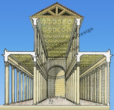
A north-south section through the Royal Stoa that stood at the southern end of Herod’s Temple Mount. The Royal Stoa was the largest structure on the Temple Mount and was built in the style of a basilica. It had a central nave and two side aisles with four rows of 40 columns. Josephus calls this stoa more deserving of mention than any structure under the sun.
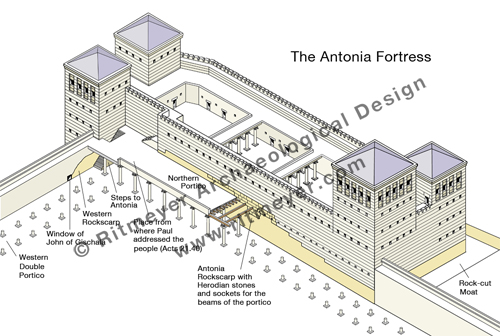
Going back to Ant. 15.413, where Josephus writes that the columns of the porticoes were 27 feet (8.23m) high, we found that this measurement is indeed correct for the Herodian porticoes. The preserved sockets of the northern portico can still be seen in the south wall of the Antonia Fortress (see drawing). They are located 8.84m (29 feet) above ground level. As the beams that were laid on top of the capitals were fixed in these sockets, Josephus’ measurement of 27 feet appears to be accurate.
The Antonia Fortress that stood at the northwest corner of the Herodian Temple Mopunt had four towers, three of which were 50 cubits (86 ft./26.25 m) high and the fourth, the southeast tower, 70 cubits (120 ft./36.75 m) high. The view from this highest tower, that, according to Josephus “commanded a view of the whole area of the Temple” (War 5.242), must have been spectacular. The location of the sockets for the northern portico are indicated in the drawing.
The reconstructed height of the newly found Hasmonean column of 6m (20 feet) is a little lower than those of the Herodian columns. The older Hasmonean portico, also known as “Solomon’s Porch”, was apparently not as high as the Herodian colonnades, as indicated in this reconstruction model.
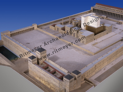
An overall view of a model of the Temple Mount looking from the northwest. In the foreground is the Antonia Fortress, while the Temple with its surrounding buildings stood close to the centre of the Temple Mount. The lower portico above the Eastern Wall (upper centre) was known as Solomon’s Porch.
A fascinating discovery recently uncovered in archaeological excavations the Israel Antiquities Authority is conducting in the Givati parking lot at the City of David, in the Jerusalem Walls National Park, has apparently led to solving one of Jerusalem’s greatest archaeological mysteries: the question of the location of the Greek (Seleucid) Acra–the famous stronghold built by Antiochus IV in order to control Jerusalem and monitor activity in the Temple which was eventually liberated by the Hasmoneans from Greek rule.
Hellenistic walls found in the Givati excavations. Photo: Assaf Peretz, courtesy IAA
It is true that the location of the Seleucid Akra has baffled archaeologists for a long time. In 2006 I wrote:
Among scholars, there is less disagreement about the historical interpretation of the Books of Maccabees and Josephus than about the topographical problems connected with the location of the Seleucid Akra, which are styled the “most debated,” “most enigmatic and “thorniest” by Simons, Avigad and Wightman, respectively.
But could the Akra have been located so far away from the Temple Mount? Both the Book of Maccabees, as well as the historian Josephus Flavius, locate the Acra in the lower city of Jerusalem:
“And they built the city of David with a great and strong wall, and with strong towers, and made it a fortress [Greek: Acra] for them: And they placed there a sinful nation, wicked men, and they fortified themselves therein” — 1 Maccabees 1:35–38
“…and when he had overthrown the city walls, he built a citadel [Greek: Acra] in the lower part of the city, for the place was high, and overlooked the temple; on which account he fortified it with high walls and towers, and put into it a garrison of Macedonians.” — Flavius Josephus, Antiquities of the Jews 12:252–253
The quote from 1 Maccabees tells us that the whole of the City of David was fortified with a wall. The Hellenistic walls found here may indeed be part of these fortifications. Josephus, however, is speaking of a separate citadel – the Seleucid Akra. This fortress we are told “overlooked the temple”. In order for the Givati remains to belong to this citadel and also overlook the Temple, it must have been over 400 feet high at least.
Once the Akra was destroyed by the Maccabees, the whole area was leveled and added to the Temple Mount. Following that, 1 Maccabees 13.52 and 14.37 tell us that,
“He strengthened the fortifications of the Temple Mount by the side of the Akra, and took up residence there with his men.… He settled Jewish soldiers in it and fortified it as a protection for the country and city, and heightened the walls of Jerusalem.”
This appears to indicate that a large area, previously occupied by the Akra, was built adjacent to the Temple Mount. This extension can still be seen at the “seam” in the Eastern Wall of the Temple Mount.
The seam in the Eastern Wall of the Temple Mount is located 106 feet orn 32 m north of the southeast corner. It shows Herodian masonry to its left (south) and Hasmonean to its right (north). Photo: Leen Ritmeyer
The fact that the Akra previouslyoverlooked the Temple Mount means that the Temple Mount could be overlooked by someone standing on the highest parts of this fortress. The fact that the southeast hill slopes away rapidly in all directions to the south of the square Temple Mount excludes all but the highest rock levels near the southern wall of the square Temple Mount as the only possible location for the Akra.
One of the cisterns in the southern part of the Temple Mount – Cistern 11 – was known as the Cistern of the Akra (Mishnah Erubin 10.14). Josephus also writes that after Simon the Maccabee had razed the Akra, “thought it would be an excellent thing and to his advantage to level also the hill on which the Akra stood, in order that the Temple might be higher than this” (Ant. 13.215).
Plan of the Cisterns of the temple Mount, indicating the location of the Cistern of the Akra. Plan: Leen Ritmeyer
The Seleucid Akra therefore stood on a hill very close to the Temple Mount. What hill is there to be seen in the Givati parking lot? It appears therefore that the Israel Antiquities Authority once again tries to make sensational headlines with an unworkable theory in order to get some publicity.
Today, Monday, November 2, 2015, the IAA circulated English and Hebrew invitations to the media to attend a press conference tomorrow (Tuesday, November 3, 2015), in the Givati parking lot at the City of David, in the Jerusalem Walls National Park, where “A Solution to One of the Greatest Questions in the History of Jerusalem” will be presented.
The Hebrew invitation states that the presentation will be made at 10:00 AM.
The English invitation states that the conference will be held at 11:30 AM, and “Archaeologists of the Israel Antiquities Authority will present the finds (in English and Russian).”
The invitation was first issued on Tuesday, October 13, 2015, and withdrawn the same day with the note that “In light of the current security situation, it was decided to postpone the event….” It can only be hoped that the decision to hold the event tomorrow is a good sign.
Now we will just have to wait for “A Solution to One of the Greatest Questions in the History of Jerusalem”.
This year is the 200th anniversary of the birth of Constantine Tischendorf, the German scholar who discovered the Codex Sinaiticus, the oldest (4th century AD) copy of the New Testament text of the Bible, at St. Catherine’s Monastery in the Sinai. He not only discovered the manuscript, but also managed to have it removed to Russia, promising to return it to the monastery. This, however, never happened and therefore Tischendorf has been not only lauded for having discovered it, but also labeled a thief for not having returned it. Because of economic hardship, the Codex was eventually sold by the Russian National Library to the British Library, where it remains until now.
Our friend Alexander Schick has researched the work of this German scholar and published a book, called Tischendorf and the oldest Bible of the World (German).
This Wednesday, at Room 211 of the Rothberg Institute, Hebrew University, Jerusalem, he will give a lecture from 6.30-8.00pm, entitled:
“Genius or Thief? Constantine Tischendorf Turns Two Hundred – the life of the famous biblehunter and the case of the Codex Sinaiticus in the light of newly discovered documents from his personal archives”
If you happen to be in Jerusalem this week, we warmly recommend attending Schick’s lecture.
In the Sep/Oct. 2015 issue of Biblical Archaeology Review, Stanley Porter, in an article called “Tischendorf on Trial for Removing Codex Sinaiticus, the Oldest New Testament”, investigates the allegations against Tischendorf in light of new evidence from the Russian archives.
The Arch of Titus which stands at the entrance to the Roman Forum draws huge crowds who want to see this well-known monument that was erected in memory of the Roman siege of Jerusalem and the destruction of Jerusalem’s Temple in 70 AD.
The Arch of Titus. Photo: Leen Ritmeyer
The interesting part is the scene portrayed on the southern intrados (inner curved side of an arch) that shows Roman soldiers carrying away the spoils of the Jerusalem Temple, i.e. the Lampstand (menorah), the Table of Shewbread and two trumpets.
The south panel showing the spoils taken from the Jerusalem Temple. Photo: Leen Ritmeyer
Today it was reported in the Telegraph newspaper that another monumental arch dedicated to Titus was found in Rome at the southeast entrance to the Circus Maximus.
Although these remains have been known for some time, they have now been more fully excavated.
The Circus Maximus. The original ground level of was 6 meters (20 feet) lower down. Photo: Leen Ritmeyer
The remains of a triumphal arch built in honour of the Emperor Titus have been unearthed from underneath Rome’s Circus Maximus chariot-racing arena.
The arch, which was built immediately after the emperor’s death in 81AD, would have formed a magnificent entrance to the Circus Maximus, where charioteers competed against each other in races that were depicted in the 1959 Hollywood epic Ben Hur.
View of the Circus site from the south-east. The remains of a column base and parts of fluted columns that belonged to the Arch of Titus had been visible in the near foreground before the excavation took place. The tower in the foreground is part of a medieval fortification. Photo: Wikipedia
The bases of four giant columns were found underground in an area that is prone to flooding. This picture shows one of them:
The excavated remains of the great Arch built for Emperor Titus at the Circus Maximus. Photo: Handout
A CAD drawing of how the great Arch at Circo Massimo may have looked.
The excavation site is now covered up until funds can be raised to reconstruct this monumental marble arch.