Todd Bolen’s thoughts on Rachel’s Tomb

Todd Bolen of BiblePlaces.com made an interesting comment in response to my post on Rachel’s Tomb, which wouldn’t show up in the comments box. Todd has an excellent knowledge of the Land of Israel and his comments are always worth reading. Here is his comment:

Leen,
Thank you for your research on this challenging issue. Porter’s explanation is certainly a creative way of handling the problem. I’ve written up an explanation which is a bit more traditional in having support from numerous scholars in the last hundred years. I will post that later today at http://blog.bibleplaces.com. I want to suggest here a few potential weaknesses in this proposed solution:
The texts locate Migdal Eder in relation to Jerusalem, not to Bethlehem. As far as I can tell, in the Sheqalim text, Migdal Eder could be any direction from Jerusalem, not near Bethlehem as you write. Micah 4:8 clearly places it near Jerusalem, not Bethlehem. In that case, Rachel’s tomb cannot be at the traditional location, because Rachel was buried north of Migdal Eder.
There is no evidence that tribal borders moved. As you say, Kiriath-jearim was located on the Judah-Benjamin border. Jerusalem was also on the north side of the border. That the borders would have expanded significantly at Judah’s expense in the period *before Saul became king* seems unlikely given Benjamin’s weakness and major population decrease (Judg 20-21). In any case, the shift proposed here is 5 miles, an enormous alteration for which we would expect to see some other evidence. The only evidence for it is the location of Rachel’s tomb, and I think there’s a much easier solution to handle this piece of data.
The first map does not correctly reflect the border description of Benjamin which runs through the Hinnom Valley *north to Mei Nephtoah* and west to Kiriath-jearim. The Mei Nephtoah point is very inconvenient for Porter’s theory, but it should not be ignored.
Thanks again for this post and your insights. As always, I benefit from your wisdom and experience.

Todd explained his own position on the location of Rachel’s Tomb in his latest post.

As I mentioned in my post, certainty eludes us as to the location of Rachel’s Tomb, as there are too many unknowns. I only put up Porter’s ideas for curiosity’s sake, as I know the difficulty of the connection with Benjamin’s border in the account of Samuel.
I remember visiting Qubur Bani Isra’il a long time ago, but didn’t know then what to make of these massive stone monuments, one of which has a small chamber built into it. My initial impression was of that of tank barriers, but I soon realised that they may be archaeological structures. Some visitors in the 19th century even called them  megalithic monuments. They were apparently also known as Kabiir el Amalikeh, the Tombs of the Amalekites. It would be interesting to excavate them.

However, as you say in your post: “The best evidence for answering this question is the oldest evidence.” In this case, it is the record of Rachel’s delivery of Benjamin and her subsequent death and burial in Genesis 35, where Ephrath is mentioned twice (vs. 16 and 19) and connected with Bethlehem in vs.19. It is highly unlikely to say the least, that two place names, at the same time, both referred to the much lesser known sites of the same name, as you suggest, and not to the places which are of such major significance in the Bible record. Although Bethlehem is assigned firmly to Judah in passages such as Judges 17.8 and Ruth 1.2, one could not expect the same in the book of Genesis, before the tribal portions had been allocated.

So, despite the problems thrown up by poorly understood later passages, one would expect the tomb of Rachel to have been located close to the entrance to Bethlehem. Its exact location remains one of those unresolved questions of Biblical geography.

Battling for the Holy Places

In response to my previous post, Joe Zias, physical anthropologist, who worked for many years for the Israel Antiquities Authority, wrote concerning Rachel’s Tomb:

Check out photographs at Yad Ben Tsvi lib. to see Islamic graves surrounding the site up to and abutting the shrine. I in fact was called in to view burial remans just a few meters to the north of the entrance which lie under the pavement in which all and everyone walks across. they were Islamic according to their orientation and no more than a few hundred yrs old. Haredim were satisified that they were not Jewish and covered up the remains (so they said).

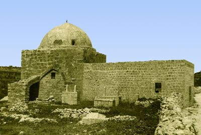
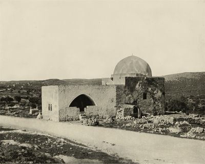
There certainly has been a Muslim graveyard next to Rachel’s Tomb for the last few hundred years. See pics below. However, a cluster of Muslim tombs does not a Muslim site make. The exterior of the eastern wall of the Temple Mount is lined with Muslim tombs, but we know a lot more about its history than that fact. Rachel’s Tomb is not just the tomb of an insignificant female character from the Bible, but of Rachel, who the Jews call Imeinu, “Our mother”, wife of Jacob, the third Jewish patriarch. The site of her tomb is noted twice in Scripture: Gen. 35.16-20 and 1 Sam. 10.2 and by numerous early pilgrims to the Holy Land.

Rachel's Tomb in 1894 - note Muslim graves around the building

The Muslims, who walked into history more than 2,500 years later, also revere Rachel and her name appears in the Koran. It is because of that association that her tomb became a popular “wely” or site to hold funerals.

Rachel's Tomb in the 1930's - note the Muslim tombs next to the building

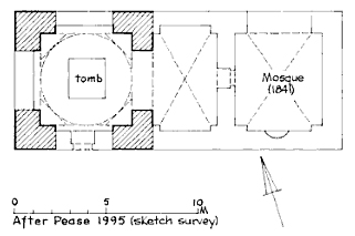
And when Moses Montefiore bought the site for the Jews in 1841, he built a vaulted vestibule for the Muslims to pray in, in order to conciliate them. Denys Pringle in his comprehensive historical note to the site in The Churches of the Crusader Kingdom of Jerusalem, (written in 1995, with no political axe to grind) provides a sketch plan of how this building relates to the tomb.

Rachel's Tomb, plan made in 1995

It is difficult to see how this Muslim reverence for Rachel translates into the recent renaming of the structure, the Bilal bin Rabah Mosque, after an Ethiopian Muslim believed to be the first muezzin! This rewriting of history is heading up for one more battle in the conflict over the Holy Places. It reminds me of the statement of a Muslim tour guide who we once employed to show us round the Temple Mount, in order to get their perspective. He told us, in all seriousness: “Melchizedek was the first Palestinian king of Jerusalem!

First Temple period wall found in Jerusalem – revisited

One of my blog readers, Arthur Chrysler, made the following comments on a previous post, which I would like to share with other blog readers:

The Large Tower, explored by Warren and one hundred years later by Dame Kenyon, is constructed of stones of the character identified as Phoenician at Samaria. The header-and-stretcher construction is also identified as Phoenician at Samaria. Kenyon stated, “The date of these earliest walls, on the basis of the deposits against them, is, on the field estimate of the pottery, eighth century B.C. OR EARLIER (Digging up Jerusalem p.115). She also states in the caption under pl. 38, “Wall in Site S II on eastern crest of eastern ridge, which can be STRATIGRAPHICALLY dated to 8th century B.C….”. This area of Jerusalem is not a Tel! You cannot stratigraphically date anything here. This unique topography, consisting of a steep slope with exposed bedrock demands unique methodology. Kenyon states that, “Close at hand, there was a wall of the time of Solomon, from which the builders of the eighth century B.C. derived their stones”. King Hezekiah had a unique style of construction as seen in the Broad Wall, the Outer Wall, and his section of wall cutting across the Jebusite angle above the Gihon Spring. None of these examples give a hint of header-and-stretcher characteristics. Why would Hezekiah go through the trouble of re-stacking Solomon’s massive stones to move the tower only a few meters? Kenyon used the dating method that she was familiar with but it led her to the wrong conclusion regarding the tower here. The tower is certainly Solomonic and the connected wall and the Golden Gate, all of which display Identical characteristics.

If it is true that nothing can be dated stratigraphically in this part of Jerusalem, how can you then insist on a Solomonic date for the wall in Kenyon’s site SII and Benjamin Mazar’s Field 23? Kathleen Kenyon excavated down to the bedrock in this area and indeed concluded that:

“Beneath … the Byzantine wall … is a wall which probably belonged to a projecting tower. The date of these earliest walls, on the basis of the deposits against them, is … eighth century B.C. or earlier.” “… these walls were constructed of re-used stones … with irregular projecting bosses having margins on one, two or three sides.”

If these stones are indeed in secondary use, which I am not convinced of, it is possible that these are rejects or surplus masonry from Hezekiah’s square Temple Mount construction.

If you would examine the elevation, section and Isometric drawing of the Ophel Wall on Warren’s Plans, Elevations, Sections, etc., (1884), Plate 40, then it is clear that this L-shaped wall is built against an earlier wall and one can still see today that two different First Temple period building phases are represented in this area. That is why Warren called this wall section the “Extra Tower” or “Corner Turret”, i.e. it is a tower that was later added to strengthen an earlier fortification or part of the city wall. If the L-shaped wall, as you insist, is Solomonic, does that make the wall against which it is built Canaanite? If there are two construction phases in a building, that is called stratigraphy, showing that one wall is earlier than another. This stratigraphy is not different from that on a tell. This picture shows that the stratigraphically four building constructions can be identified:

1. The Byzantine Tower
2. Excavating inside and below the Byz. tower, a Herodian mikveh was found that was built against the inside wall of the “Extra Tower” (not visible in the picture)
3. The 8th century L-shaped “Extra Tower”
4. The pre-8th century wall against which the “Extra Tower” was built, which may be Solomonic if that can be proved conclusively.

Kenyon dated this L-shaped corner construction to the eighth century B.C. or earlier, but that does not necessarily mean that it is Solomonic. You compared it with the Phoenician masonry in Samaria, but that dates to the 9th century and is not Solomonic. A similar style masonry has been found in the sanctuary walls in Tel Dan, which is also post-Solomonic. I had suggested that there is an historical link between the “Extra Tower” and the masonry near the Golden Gate, but neither of these two constructions can be Solomonic.

The Antonia, Herod’s Temple Mount Fortress

In the Jan/Feb 2009 issue of Biblical Archaeology Review, an article was published by Ehud Netzer, called “A New Reconstruction of Paul’s Prison”. Netzer is a respected and successful architect/archaeologist and well-known for his excavations of Herodium and Hasmonean and Herodian Jericho and other Herodian sites. Recently he amazingly found the long-lost tomb of Herod the Great.

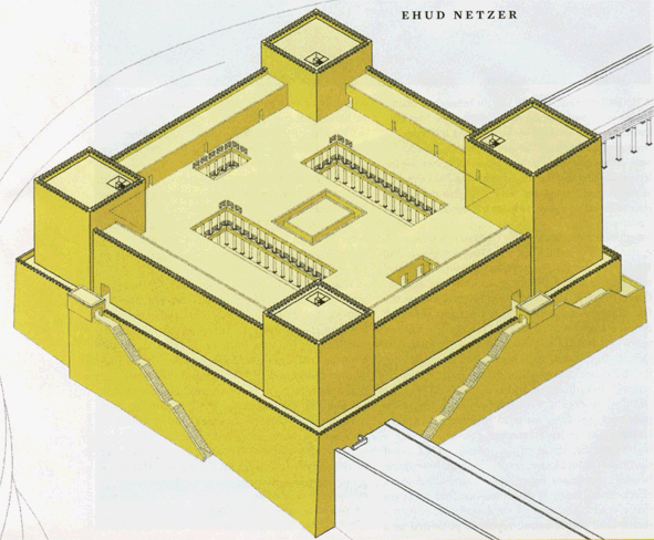
In the last few years he also tried, less successfully in my opinion, to reconstruct Herod’s Temple Mount. His reconstruction proposal for the Antonia Fortress is a clear example of ignoring important historical sources and archaeological evidence. Here is his reconstruction:

As far as historical sources are concerned, Josephus (War 5.238-246) wrote that “The tower of Antonia lay at an angle where two porticoes, the western and the northern, of the first court of the Temple met; it was built on a rock fifty cubits high and on all sides precipitous.”

The reconstruction of Netzer does not meet these two historical requirements. The northern and western porticoes don’t meet and no rockscarp is to be seen in Netzer’s drawing on the south and west sides. Indeed, there never were precipitous rockscarps in the area occupied by the southern and south-eastern part of his reconstruction.

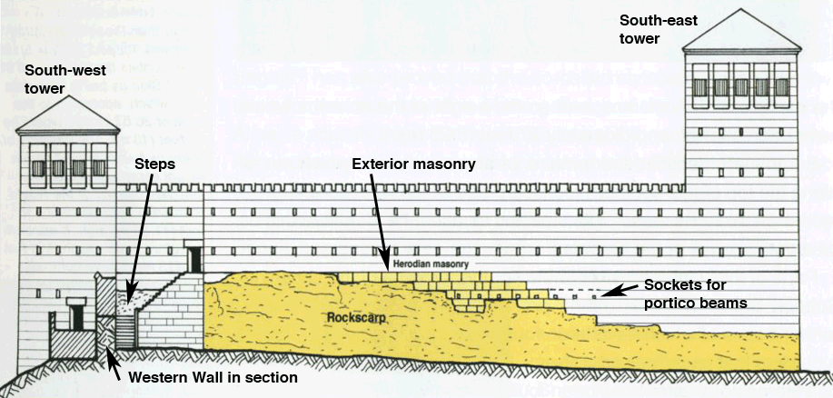
There is archaeological evidence that the two porticoes did in fact meet. Sockets for the roof beams of the northern portico can still be seen today in the northwest corner of the Temple Mount, see Ritmeyer, The Quest, Revealing the Temple Mount in Jerusalem, p. 130), see:

These sockets were placed in exterior Herodian masonry, which is visible high above the still-existing rockscarp. This masonry consists of ashlars with the typical Herodian margins, which were used for exterior masonry only. This proves that this rockscarp with its Herodian masonry was an external wall, namely the southern wall of the Antonia Fortress and not an interior wall. This also shows that the northern portico of the Herodian Temple Mount ran in front of the southern facade of the fortress, enabling it to “meet” with the western portico, as described by Josephus.

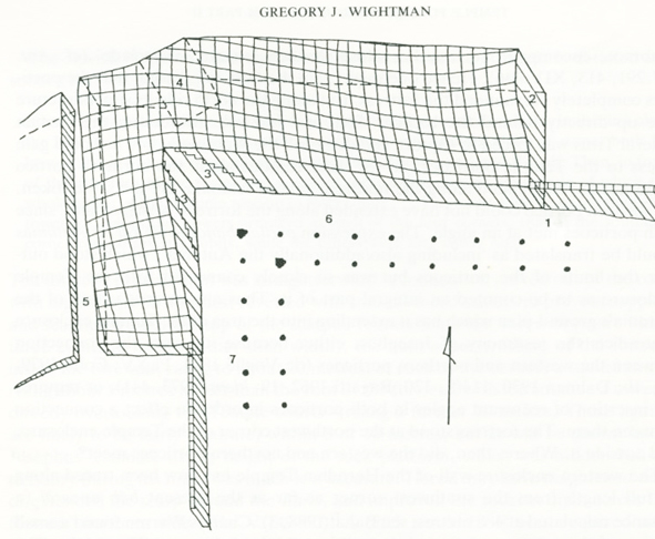
Netzer places the south-western corner of the fortress at small projection in the Western Wall. This projection exists, possibly because of the lay of the bedrock, but it is too insignificant a projection for the south-west tower of the Antonia. There is a much larger projection to the north, which is completely ignored by Netzer. It can be seen in the western side of the north-west corner of the Temple Mount and at the end of the Western Wall Tunnel. This projection has been mapped by Gregory Wightman (Temple Fortresses in Jerusalem, BAIAS, Vol. 10, pp. 7-35) in this diagram:

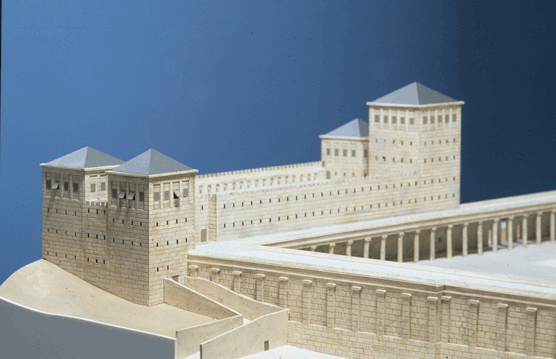
It shows that the south-west tower projected much more from the Western Wall than shown in Netzer’s reconstruction. All of these historical and archaeological data, ignored by Netzer, have been incorporated into my own reconstruction of the Antonia Fortress as shown in this model:

Original Herodian paving stones were, until recently, visible in the north-west corner of the Temple Mount. Netzer’s reconstruction does not relate to this pavement. Netzer’s Antonia plan is square, although the north-west corner of the Temple Mount is in fact not a right angle, but an acute angle of approximately 86 degrees.

In 1975, P. Benoit (The Archaeological Reconstruction of the Antonia Fortress, Jerusalem Revealed, 1976) has brilliantly shown that the Antonia was located exclusively on the rockscarp at the north-west corner of the Temple Mount. Prior to this time, several scholars, such as De Vogüé and Vincent, had promoted a larger Antonia which projected inside the Temple Mount. It is a pity to see that Netzer has regressed to that earlier and by now obsolete reconstruction of the Antonia Fortress.

The Temple of Jerusalem and the Colosseum

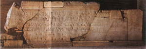
One of the readers of my blog commented on an interesting connection between the Colosseum and the Temple of Jerusalem, mentioning that Prof. Louis Feldman had discovered an interesting inscription in the Colosseum in Rome. This is the stone with the inscription:

I met Prof. Feldman when I was in New York earlier this year. He did not claim to have discovered or deciphered the “ghost” inscription, for that was done by the renowned scholar Gezah Alfoldy. Feldman wrote an interesting article for BAR (July/August 2001), in which he explained how Alfoldy arrived at his conclusion. The inscription in question was carved in Latin on a stone, which is displayed in one of the entrances to the theater. This stone once carried an earlier inscription. That inscription was made of metal (probably bronze) letters which were fastened to the stone with pegs. The holes for the pegs are still visible on that stone. Alfoldy used the location of the peg holes to reconstruct the inscription and came to the conclusion that it commemorated the building of the Colosseum by Titus from the spoils of war. Feldman then suggested that the war in question might have been the Great Jewish Revolt against Rome, which resulted in the destruction of the Temple in 70 A.D.

Herodian drain found in Jerusalem

It has been reported in the media (see for example BBC news and the Jerusalem Post) that excavators Ronnie Reich and Eli Shukrun have excavated a large section of the drain that was located just below the Herodian street. This drain was constructed, so that the rain water that fell on the street and the liquid sewage of adjacent buildings could be disposed off. Here is a picture of the drain (AP Photo/Emilio Morenatti):

drainpic.jpg

Parts of this drain have been investigated by Charles Warren (1867-1870) and other sections have been excavated by Bliss and Dickie (1894-1897), Johns (1934), Kathleen Kenyon (1961-1967) and Benjamin Mazar (1968-1978). The section found by Mazar below Robinson’s Arch was vaulted and believed to have been a relay of the original drain which had been cut by the south-west corner of Herod’s temple Mount, see this picture from The Quest, p.56:

swcorner1.jpg

Warren also investigated a much earlier drain, lower down in the Tyropoeon Valley, so that we know of two different drainage systems. Together with the relay mentioned above, there are three different phases in this drainage system, which indicate three different building phases in the construction of the Temple Mount, see The Quest, pp. 233-235.

The present excavators have not yet provided a map of the excavated drain, but only said that is was between the Temple Mount and the Siloam Pool. In the 1890’s, Bliss and Dickie discovered a large section of the Herodian street near and to the north of the Siloam Pool. This section alone shows that the main street, which, we believe began at the Damascus Gate and followed the Tyropoeon Valley and exited at the South Gate – see map below. On this map we have plotted the street section that was found by Bliss and Dickie in grey with the drain in red:

drain.jpg

As the excavators have been digging in the vicinity of the Siloam Pool, the newly found drain is likely to be located just north of the pool. This find received a lot of media coverage because of the remarks made by the excavators that this drain may have been used by people who tried to escape the Roman destruction of Jerusalem in 70AD.

Digging the Temple Mount – the location of the Altar

Recently I received this email:
Shalom Dr. Ritmeyer
According to the Talmud a very very deep pit was present at the south western corner of the second temple altar to receive libations. Is there any pits that we know about that are likely canditates for the pit of the libation pit.
best wishes
Shlomo Scheinman

Answer:
None of the cisterns or other cavities that have been recorded by Warren could be identified as the libation pit you mention. The area in which the altar was located, just to the east of the Dome of the Rock (see previous post on The New Sanhedrin and the Temple Mount), has never been excavated. Yet I believe that Shlomo is right, for it is mentioned in Middot 3.3 that “at the [south-west corner of the altar] in the pavement below was a place one cubit square where was a slab of marble on which a ring was fixed; by it they used to go down to the pit and clean it.”
According to the bedrock levels, the altar stood on the rock, which is located about 1 meter below the level of the present platform, which is indicated by the lower blue line on the drawing. I believe therefore that the foundation of the altar may still be there. The following drawing, which is an east-west section through Herod’s Temple and the Altar (in red) and the Dome of the Rock and the Dome of the Chain (in blue) shows how these structures were related to the bedrock (i.e. Mount Moriah)

altarlocation1.jpg

The pit therefore must have been carved out of the rock, including possibly the channel that drained the water and the blood from the sacrifices and the libation offerings into the Kidron Valley. There is a real possibility that these remains are preserved and it would take only a little bit of excavation to find it. How exciting that would be!

Patrich’s Response

Since the previous post I made on the topic of Joseph Patrich’s Temple Location theory, I have been in contact with him to clarify that I do not agree with his position. He replied with the following and has graciously allowed me to post it here:

Sorry Leen, I was not aware that people will give such interpretation; I just wanted to credit you as the artist. This and only this. In the press released it was said: “Drawing (Temple1) shows Prof. Patrich’s description of the location of the Temple compound (the rectangle defined by a solid line in the center of the drawing). (Drawings by Leen Ritmeyer).” In Hebrew it says: Drawn by Leen Ritmeyer following Prof. Patrich’s instructions.” The sole legitimacy I am looking for is from my own arguments, based on the archaeological data and the Rabbinic sources. From now on I’ll refrain from this. I know your ideas are entirely different than mine. Sorry it caused you embarrassment.

I hope that posting this helps to clarify that even though as a friend I helped him with the drawings, I do not agree with his position.

Response to Joseph Patrich’s Temple Location

I have known Joseph Patrich for many years and have worked with him in the past to develop ideas about the construction of Herod’s Temple (Patrich, J. (1986). “The Messibah of the Temple According to the Tractate Middot” in Israel Exploration Journal 36, pp. 215–233. Patrich, J. (1987). “Picturing the Second Temple” in Eretz Magazine, Spring 1987, pp. 67–70 ).

He recently approached me with the request that I draw up some plans to illustrate his ideas on the location of Herod’s Temple. I agreed to help him, but made it clear that I did not want to be associated with his research, as I do not agree with it.

As one can see in my recently published book The Quest, many factors need to be taken into consideration when determining the location of the Temple. The location of one of the 38 cisterns on the Temple Mount is insufficient evidence to use as a basis for the site of the Temple. According to the ancient sources, the Temple faced east and not south-east:

Josephus – The Jewish War, 5.222

Now the outward face of the temple in its front wanted nothing that was likely to surprise either men’s minds or their eyes; for it was covered all over with plates of gold of great weight, and, at the first rising of the sun, reflected back a very fiery splendor…

Mishna Middot 2,4

All the walls there were high, save only the eastern wall, because the [High] Priest that burns the [Red] Heifer and stands on the top of the Mount of Olives should be able to look directly into the entrance of the Sanctuary when the blood is sprinkled.

Patrich places the ramp of the Altar between the northern two branches of this Cistern no. 5, to explain how water could have been drawn for ritual purposes. However, neither of these two branches have well-heads, so that water could not have been drawn up to the Laver, as he proposes.

Patrich’s location of the Temple

Patrich’s proposal as it appears here.

As convenient as this theory may appear, as it leaves the Dome of the Rock outside the Temple site, it is completely unworkable. It therefore joins the equally nonviable Temple location theories such as the northern one of Asher Kaufman, the symetrical layout of David Jacobson (which places the altar at the center of the Temple Mount) and the southern proposal of Tuvia Sagiv. Only a location which takes into account all the historical and archaeological evidence is tenable.

My proposal for the location of the Temple, as documented in The Quest and Secrets of Jerusalem’s Temple Mount is as follows:

Temple Mount Plan

I hope to offer responses to the other theories in due course.