Having recently updated our Image Library with about 40 new illustrations, we have received enquiries as to how this online resource came into being. As its creation was a process that took many years, you may be interested to read its story. We were privileged to live in Israel for a long time, so most of the images come from the Land. However, in recent years, we have managed somewhat to break the exclusive hold that Israel has on us and branch out into the surrounding Bible Lands.
What is unique about these images is the fact that most of them are reconstruction drawings. Most picture libraries are just that – pictures of sites. But when you are faced with the challenge of giving a talk on a Bible subject, you don’t just want to show a picture of ruins. You want to give your listeners an insight into the past by building up the stones into a structure where you can imagine Biblical events taking place. The same goes for picture editors looking for illustrations to help readers visualise how sites looked in antiquity.
We may take the idea of reconstruction drawings for granted today, but going back to the heady days after the 6-Day War, when there was an explosion of archaeological excavations, particularly in Jerusalem, there were very few around. Many archaeologists adopted a cautious, purist approach and found it a bit “risky” to take decisions as to a building’s original appearance. My foray into making reconstruction drawings stemmed from the experience of giving tours on the Temple Mount dig, whilst working on the site as surveyor. I used to try explaining features like Robinson’s Arch, the arched staircase that led up to the Temple Mount from the Western Wall street in the time of Christ, with my hands and feet. From questions I got asked afterwards, I realised that not everybody had “got it”!
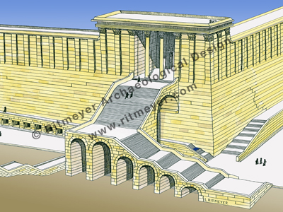
Thus, my first reconstruction drawing of Robinson’s Arch and a career as an archaeological architect was born. It was all based on study drawings of the known elements, comparative architecture and research into the historical sources. Seeing peoples faces change from incomprehension to clear understanding sold me on the vital need for such drawings. I was blessed that the late Prof. Benjamin Mazar, who directed the dig, agreed and could not have been more encouraging.
As there were few others at the time making reconstructions (now it is a recognised field), I was asked to visit many sites to help visualise the original structures. Talk about “going over the cities of Israel!” These digs ranged from Ai, Beersheba and Dan to Shechem, Shiloh and Timnath of the Philistines.
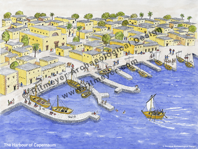
I learnt much from the older school of archaeologists, such as the afore-mentioned Professor Mazar, who kept a copy of the Taanach, or Hebrew Bible on his desk, consulting it daily and calling it “our history book!” And Mendel Nun, a resident of Kibbutz Ein Gev on the Sea of Galilee (who died recently at the age of 92) did so much research into methods of fishing on the lake in ancient times, that I was able to make a drawing of the harbour of Capernaum in the time of Christ.
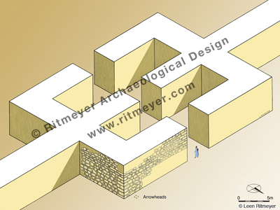
However, it was Jerusalem that was always the centre of my endeavours and I was also involved in the other two major digs that took place in the city, namely the Jewish Quarter Excavations and the Excavations in the City of David. Included in the Image Library is a picture from the former dig, directed by Prof. Nachman Avigad, of a building originally identified as part of an Israelite tower. However, as the dig expanded, it became clear that it could not have been a tower as one side was missing! One day, after returning from working on the summer season at the site of Timnath of the Philistines, I realised, from my experience of digging a gate of this period in Timnath, that we were looking at a similar structure here in the Jewish Quarter. From its location in the upper city, it became clear that it should, in fact, be identified as the Middle Gate of Jeremiah 39.3. Arrowheads found close to the site revealed the destruction of the city in the time of Zedekiah. Our hands got black with soot – tragic evidence of the fall of Jerusalem.
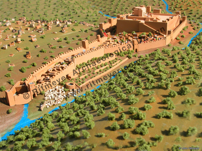
We left Israel during the First Intifada, as heightened security made it virtually impossible to work on many of the sites I was involved in in the West Bank. Having moved to the UK to do my Masters in Conservation Studies at the Institute of Advanced Architectural Studies of the University of York (another walled city), one of the projects I was asked to do was to design models of the Tabernacle, Solomon’s Temple and Herod’s Temple and Temple Mount for a Jewish philanthropist in Washington D.C. Photographs of these models, beautifully crafted by York Model Making, are included in the Image Library.
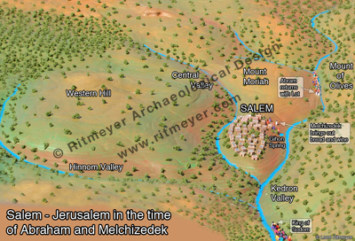
My Ph.D thesis entitled: “The Architectural Development of the Temple Mount in Jerusalem” (University of Manchester) necessitated the creation of many drawings to illustrate different aspects of this subject. And subsequently, during the years we lived in Australia, whilst teaching Hebrew and History at Heritage College Adelaide, I made models of Jerusalem in the different periods with some of my students. The process developed the students’ understanding of the city’s history immeasurably and resulted in models, some of which were unique in the history of model making, especially of the periods of Melchizedek and Nehemiah.
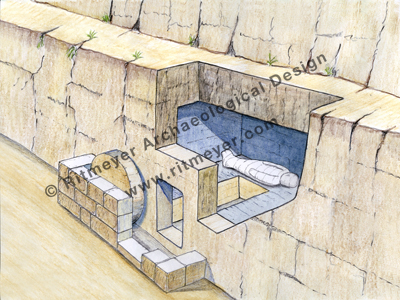
One aspect of our recent work with the ESV Study Bible required me to think about what the tomb of Jesus would have looked like, which brought about this brand new drawing.
And part of the project I did for the GLO Immersion Digital Bible involved making maps of all of Christ’s journeys. I have included in the Image Library this map of his last journey in Jerusalem. The traditional Via Dolorosa or Path of Sorrows was fixed by monks in Western Europe in the eighteenth century and a devotional procession along this route is still led by Franciscans every Friday. In fact, the streets upon which Jesus walked lie about 10 feet below the level of these thoroughfares. By contrast, this drawing called “The Way to Golgotha” is firmly based on Scriptural and archaeological evidence. This drawing is also available as a Bible Chart, which is one of our Photographic Posters that are individually designed and printed on A3 (297 × 420mm or 11.7 x 15.5 inch) size, high-quality, thick photo paper (paper weight 100 lb. or 270 g/m2).

A project that has added new drawings to the collection was the commissioning of artwork for Tyndale House Publishers Chronological Life Application Study Bible. These included reconstruction drawings of Jerusalem in the periods of David, Solomon, Hezekiah and the first century. See this recent post.
The Image Library also includes many photographs from a recent study tour of the Seven Churches of Revelation located in modern-day Turkey. Who knows, these may some day also be turned into reconstruction drawings! Tips for using the Image Library will hopefully be the subject of a future blog.

Very interested in seeing what things looked like. Have some of your books, my parents John and Leslie Carder appreciated your insights, they studied and even excavated at sites in Israel.