
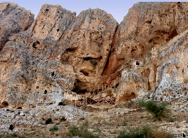
Judith Sudilovsky reported in the Jerusalem Post on the opening of the Arbel Fortress following 1.5 years of conservation work.
“Towering majestically over Lake Kinneret, looking out over a breathtaking view of the upper and lower Galilee including Mt. Nitai, and further towards the Golan Heights and Mt. Hermon, the stark cliff of Mt. Arbel has been witness to plenty of history.”
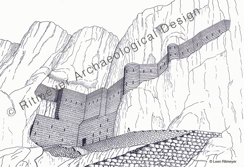
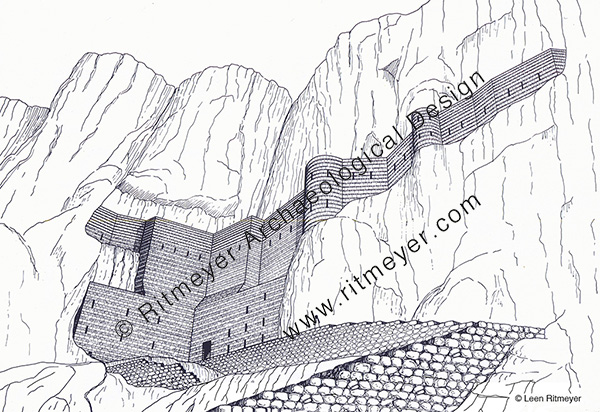
The cliff hanging Arbel Fortress in question is known as Qala’at Ma’an. It was built in the beginning of the 17th century AD by Fahr al-Din II, of the Druze Ma’an dynasty, governor of Lebanon and Galilee.
“The fortress was not allowed to stand for too long, and within a decade of its construction Ottoman forces destroyed it for reasons unknown. Time and nature did their share, and over the centuries the three-story fortress—a popular site for intrepid hikers to visit–fell into great disrepair making it dangerous for visitors.”
Despite its short existence and subsequent neglect by both nature and pillage by men, the Arbel Fortress still has an imposing presence hanging halfway down the cliff. We are grateful for this conservation project that makes the site more accessible for visitors who can also enjoy the spectacular views of the surroundings.
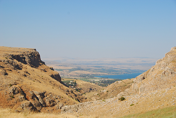
Arbel is a site of uncommon natural beauty with steep cliffs plunging down toward the Sea of Galilee, overlooking Wadi Hammam, Magdala, the place where Mary Magdalene lived, and Capernaum.

For a long time, it was thought that Fahr al-Din’s citadel was the fortress of the Jewish rebels who fought against Herod. The late Zvi Ilan conducted a systematic survey of these caves in 1987- ‘88, in which I participated. The actual caves were located on a trail on which, for decades, hikers walked to the Ottoman fortress. Initially, Zvi had no idea that the real caves were hidden only a few meters away! During the Hasmonean period, about one hundred caves were hewn in the cliff for residential purposes and protected by walls. Some caves contained two or three rooms. The survey showed that the outer wall of the fortress of Fahr al-Din was built in front of some of those Hasmonean caves. This caves consisted of rooms, cisterns, stairways and even a mikveh that was found on the third floor.
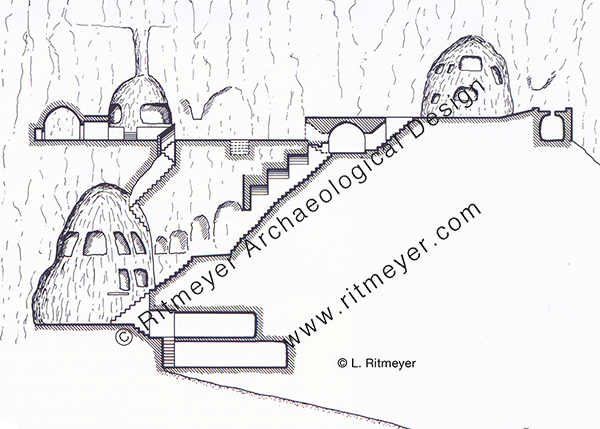
To his great surprise, Zvi Ilan discovered another cave fortress to the east of the Ottoman fortress that was 75 meters long, 14 meters wide and 10 to 12 meters high. A long wall was built in front of it, to the top of the hewn rock. An interior wooden walkway was constructed between the caves and the wall. The date of this fortress could not be established without a future excavation. However, according to Zvi, the possibility that this fortress was built as part of the preparations for self-defence at the site at the end of the Second Temple period, should not be ruled out.
As mentioned in Judith’s article, Arbel has seen plenty of history even though it is so little known. What is known about its history?
The ancient settlement and lookout post of Arbel may have been the one that is mentioned in the Bible as Beth-Arbel. This fortress was destroyed by Shalmaneser V in 722 BC, when he was on his way to capture Samaria: “all your fortresses will be devastated – as Shalman[eser] devastated Beth Arbel on the day of battle, when mothers were dashed to the ground with their children.” (Hosea 10:14). The defeat of this settlement must have been particularly brutal and an example to Israel of the cruelty of the Assyrian invaders.
The fertile land on the Valley of Arbel that is watered by the abundant water that flowed through it, enabled the inhabitants of Arbel to grow grain, olives and grapes, and flax that was used in the production of linen. This supported a strong economic base for Arbel that was built on terraces in the rocky slope on the northern periphery of the Arbel Valley.

Two great legal minds of the mid-second century BC, the sage Nitai the Arbelite, who was born here, and Joshua ben Perahiah taught Torah using a Deuteronomy scroll that these two sages had received from Simon the Just, who was then High Priest in Jerusalem (Mishnah Avot 1:6). Nitai was also vice-president of the Sanhedrin. This indicates the high level of development of Arbel as a spiritual centre for Galilee.
The ancient settlement was almost entirely surrounded by cemeteries. Later traditions mention Arbel as the burial place of Nitai of Arbela; Dinah the daughter of Jacob, and several of her brothers; and that of Seth the son of Adam, and the exilarch Hezekiah, a leader of the Jewish community from the time of the Babylonian exile.
Arbel is now also known for its unique system of the above-mentioned fortified caves where Hasmonean loyalists fighting the Galilean Zealots hid. In 161 BC, a deadly battle took place at Adasa between the Maccabean forces led by Judas and the Seleucid forces that were commanded by Nicanor. The Seleucids were defeated and Nicanor was killed. In order to revenge his death, Demetrius the Seleucid king sent his general Bacchides the following year to the land of Judea. “They took the road to Galilee and besieged the Mesalot (fortified caves) in Arbel and captured it and put many people to death” (1 Mac. 9:2).
In 38 BC, Herod tried to conquer the land with Roman support and battled the supporters of Antigonus II, the last Hasmonean king of Judea, who were hiding out in these caves. Herod’s men fought for forty days to no avail. Herod then devised a plan whereby soldiers would be lowered from above in crates connected to iron chains. After a bloody battle, Herod’s forces eventually routed the Jewish rebels.

In 66 AD, at the beginning of the First Jewish-Roman war, Josephus fortified the caves with walls and used them as storage base at the beginning of the First Jewish-Roman war.
After the Roman destruction of Jerusalem in 70 AD and the Bar-Kochba rebellion that lasted from 132-136 AD, many Jerusalem Temple priests fled to villages in Galilee. It was then that the association of Arbel with the concept of Messianic redemption became widespread. One poet from Tiberias claimed to have seen an appearance of the Messiah in the plain of Arbel on the eve of Passover.
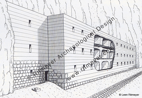
In the fourth century, a synagogue was built in Arbel (see image above), which we will report on in the next post.
Thanks to the conservation work, both these fortresses and the caves can be safely visited again, a wonderful opportunity for hikers and people that love the land. These caves are also located on the Jesus Trail. This is a 40 mile (65 km) long hiking and pilgrimage route following the road that Jesus would have taken when he moved from Nazareth and went to live in Capernaum. It goes through the Wadi Hammam that is located between the Horns of Hattin of Crusader fame, or rather infamy. Hikers will surely enjoy seeing the renovated Ottoman fortress and the many caves that bring history to life.