Eve is a long-time community activist and tour guide from the Judean hills. Her extensive work in Israel advocacy has taken her all over the world. Each week she discusses archaeology, nature and interviews Israelis on current events in the Middle East and the Jewish world.
In the wake of the publication of our guidebook to the Temple Mount, she wanted to know how we got involved with the archaeology of Jerusalem and especially that of the Temple Mount. Our part of the interview, called “Preserving the Holy” was broadcast on April 5th and can be listened to here.
I was recently interviewed by John Enarsson of “Cry for Zion” on Temple Mount issues and also on our new guide book to the Temple Mount, which we reported on in previous posts here and here. These are some of the questions that were asked:
1. Do we know beyond a reasonable doubt that the (1st and) 2nd Temple stood on the Temple Mount? Why? What would be the most important reasons?
2. Do we have good reason to believe that the Holy of Holies was centered on the Foundation Stone? Why? What is the feeling in the scholarly field on this question?
3. A few years ago, you debunked the sensationalistic theories of Ernest L. Martin. Today, the adventurer and author Robert Cornuke is making Martin’s ideas about the Temple popular again to a wider audience. Have you read Cornuke’s book TEMPLE and could you comment on it?
4. Josephus has long been a favorite source for archeologists. What role do traditional rabbinic sources like the Mishnah play for archeologists like yourself?
You can listen to the 30-minute audio podcast, which includes the interview, here:
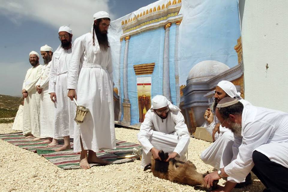
“This was the most accurate and authentic reenactment of this service to have taken place in nearly 2,000 years.”
It included all the stages of the ritual, such as checking the animal for blemishes, slaughtering it, collecting its blood and bringing it to the corner of the altar, skinning the animal and separating its inner parts, and roasting it whole in a special Passover oven.
Breaking Israel News reports on an altar that has been built by the Temple Institute. You can read the report here.
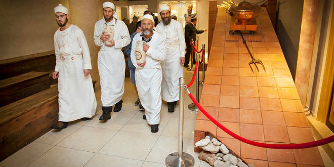
The altar built by the Temple Institute to be used in service in the rebuilt Third Jewish Temple. (Photo: The Temple Institute)Priests carrying vessels near the Ramp of the Altar
According to this report, the Temple Institute in Jerusalem has completed the construction of the stone altar required for the sacrificial service in the Holy Temple. One thing that makes this altar unique is that it was designed to be disassembled and quickly reassembled in its correct position on the Temple Mount. According to the Temple Institute,
“The people of Israel are required to build an altar exclusively on the site of the original altar on Mount Moriah, the Temple Mount. When circumstances become favorable, this new altar can be quickly re-assembled on the proper location, enabling the Divine service to be resumed without delay.”
It was a little strange to see the red tiles and bricks, but they are supposed to be the outer layer only, while the inner part was built with natural stones.
A few years ago, the Temple Institute asked me for lectures regarding the layout of the Temple and the location of the Altar. They appear to agree with our plan as shown in our new Temple Mount guide book. In our book we show a plan of the altar in relation to the Dome of the Rock and also a photograph with its location:
This plan shows Herod’s Temple, courts and Altar (beige) in relation to the Dome of the Rock and the Dome of the Chain (blue). The Rock inside the Dome of the Rock was the Foundation Stone of the First and Second Temples on which the Holy of Holies was built. The Dome of the Chain stands on the former Porch that was built in front of the magnificent Temple built by Herod and the great Altar of Burnt Sacrifices stood to its east.A view of the Dome of the Rock, looking west, with the Dome of the Chain to its east. The Altar stood in the open space between the Dome of the Chain and the steps that lead up to the Raised Platform from the east.
One wonders when and how the Temple Institute will be able to build this altar in its original location.
Yesterday we received the first copies of our guide book to the Temple Mount. It has 160 pages and 184 illustrations and weighs only 350 grams (12 ounces). It measures 20.8 x 14.3 x 1 cm (8.1 x 5.6 x 0.4 inches), which is a handy size to carry around with you and would fit easily in a large pocket or small bag. It is now possible to order our guide book directly from our website. The cost is US$25.00 or UK£17.00 plus postage.
We hope and feel sure that our book will enhance your visit to the Temple Mount and deepen your understanding of the fascinating history of this important site!
We are pleased to announce that it is now possible to order our new guide book to The Temple Mount in Jerusalem from the Carta website. We thank all the people that have written to Carta to have this guide published.
Todd Bolen of BiblePlaces was alerted by one of his friends, Austen Dutton, that the bridge of the skull’s nose had collapsed. You can read Todd’s interesting post here.
Waiting for the publication of our Temple Mount guide book, we are excited to note that it will highlight remains of the ancient Temple platform that have not been identified previously. We have long known of a massive stretch of what appears to be Herodian pavement on the Temple Mount, which, as far as we know, has never been reported before. Here is a foretaste of some of the new discoveries described in our book.
In a previous post, we reported on some massive Herodian paving stones that are now covered by olive trees planted in a thick layer of soil that has been brought into the Temple Mount for that purpose. Another large Herodian paving slab can be seen beneath the Dome of the Spirits.
The Dome of the Spirits is built on a large Herodian paving stone, which measures 12 feet (3.70m) by 11.5 feet (3.50m). According to Warren’s survey maps, it is situated approximately 10 feet (3.00m) above the natural bedrock. It was part of the pavement that was laid north of the buildings that surrounded the Temple. Photo: Nathaniel RitmeyerThis plan shows in yellow the large Herodian paving stone beneath the small Dome of the Spirits that stands on the Muslim platform of the Temple Mount. This paving stone was part of the paving of the Temple Courts of the Herodian Temple Mount. It has been erroneously claimed to be the location of the Holy of Holies by Prof. A. Kaufman.This plan compares the size of the paving stone (1) beneath the Dome of the Spirits (Qubbat al-Arwah) with similar sized paving slabs in front of the Double Gate (2) and the Triple Gate (3). The projection at top right of paving stone 1 allowed a smaller stone to be laid next to it, a feature common in Herodian architecture.
We now like to report on a large stretch of ancient paving stones that are located in front of the Gate of the Cotton Merchants (Bab al-Qattanin), at a distance of 45 feet (13.70 m) from the Western Wall.
This picture shows a large stretch of Herodian paving stones that is located in front of the Gate of the Cotton Merchants. The rows, which are about 3 feet (1m) wide, run from east to west at a distance of 45 feet (13.70m) from the Western Wall. Some of these stones are 13 feet (4m) long!
These massive paving stones are different from the normal small paving stones one sees everywhere on the Mount and appear to be Herodian in origin.
What can we learn from the position of this stretch of pavers and what is the importance of its western termination?
This plan shows the stretch of large Herodian paving stones that is located in front of the Gate of the Cotton Merchants in relation to the Western Wall.
According to Josephus (War 5.190-2), the Herodian Temple Mount was surrounded by double porticoes. When reconstructing the double porticoes of the Temple Mount we need to take into consideration the width of the underground Herodian passageways, e.g. Barclay’s and Warren’s Gates and the Double Gate. These are 18 feet (5.50m) wide. This shows that the space in between the columns, which presumably stood in square bays, must have been 18 feet. To get the width of the Western Portico, we need to double this measurement plus the thickness of two columns (e.g. 2 feet or 0.60m approx.) plus the thickness of that part of the Western Wall which is above the platform (5 feet or 1.50m). This gives the measurement of 45 feet, which is exactly the distance between this pavement and the exterior of the Western Wall. We presume therefore that the western edge of this massive paving would have been laid next to the Western Portico.
It is exciting to contemplate that this is one of the few places on the Temple Mount where one can walk on paving stones that have survived the Roman destruction of 70 AD and subsequent depredations of the site.
Continuing our series on the historical development of Mount Moriah, we have now reached the Early Muslim period. The end of the Byzantine period in Jerusalem was heralded by the Persian invasion of 614 AD and completed by the Muslim conquest twenty-four years later. Muhammad’s successor, Caliph Omar, accepted Jerusalem’s surrender in 638 AD. Muslims regarded Jerusalem as a holy city and Jews were again granted the right to live there and pray on the Temple Mount. Some sources record that Omar ordered the site of the Temple Mount to be cleared of rubbish, thus exposing the Foundation Stone of the Jewish Temple.
This cutaway drawing of the Dome of the Rock shows The Rock around which this Islamic structure is built. The Rock, shown in yellow, was the Foundation Stone of the First and Second Temples on which the Holy of Holies was built.
Caliph Abd al-Malik (685-705 AD) built a magnificent center for Muslim pilgrimage on the Temple Mount, called the Dome of the Rock.
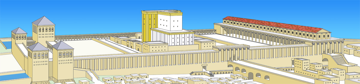
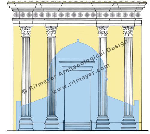
Drawing of Herod’s Temple Façade and the silhouette of the Dome of the Rock (in blue). The height of Herod’s Temple was 172 ft./52.5 m, one and a half times higher than the Dome of the Rock, which is 115 ft./35 m high.
Completed in 691 AD, the Dome of the Rock was neither a mosque nor a place of prayer, but a shrine to the Foundation Stone of the Temple. Modelled after Byzantine centrally designed commemorative churches, the Muslims transferred to the Temple Mount the story of the Night Journey of Muhammad from Mecca to the “farthest shrine” (al-Aqsa). From here they believed he ascended into Heaven. Now one of the world’s most iconic buildings, known to virtually everyone on the planet, the golden dome that shimmers against the often cobalt blue sky and the blue tiled walls of the octagonal building are both contrasting and harmonious. Few visitors to the site today, however, realise how difficult it is to express its beauty in either geometrical designs or mathematical formulae, especially as we no longer have its original blueprint.
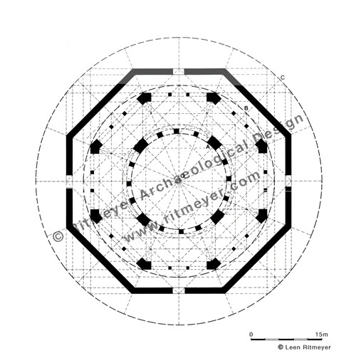
Writing this blog reminded me of the time I worked on the architectural reconstruction of a funeral monument called Gonbad-e-alawiyyan in Persia (Iran) for an Israeli colleague. From this I developed an analysis which is also valid for the plan and section of the Dome of the Rock, the crowning glory of early Islamic architecture. Too complex to describe fully here, it is based on three concentric circles which closely bind together all the different constructional elements into one magnificently proportioned building.
This centrally designed building ranks among the most beautiful buildings in the world. Our new analysis requires the taking of one measurement only that is then divided into three equal sections (OA=AB=BC). From the centre (O), three concentric circles are drawn through A, B and C. The subsequent inner and outer octagons and star octagons of each circle create a pattern that can be used with many variations for the accurate location of walls, piers, columns and openings.
I later applied it successfully to other classical centrally designed buildings, such as the Round Temple at Baalbek, San Vitale at Ravenna, the Mausoleum of Diocletian at Spalato, Hagia Sophia in Istanbul and many others. It is intriguing to think that here we may have a certain school of ancient architecture, which was in use for a long period, but whose traditions were eventually lost.
The Temple Mount in the Early Muslim Period. The Dome of the Rock was built on the site of the Jewish Temple and the al-Aqsa mosque on the location of the Royal Stoa above the Southern Wall of the Temple Mount.
On completion of the Dome of the Rock, Caliph al-Walid (705-715 AD) built a mosque called al-Aqsa above the Southern Wall of the Temple Mount, on the former site of the Herodian Royal Stoa. The Temple Mount was and still is known to the Muslims as al-Haram al-Sharif (The Noble Sanctuary). The Virtual Walking Tour of al-Haram al-Sharif produced by Saudi Aramco World led by Oleg Grabar, the late Professor Emeritus of Islamic Art and Architecture at the Institute for Advanced Study at Princeton, New Jersey, allows one to explore its jewels of Islamic architecture in a very informative way.
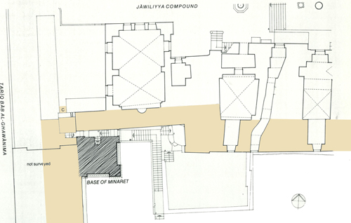
In our previous post, we wrote about the archaeological remains at the northwest part of the Temple Mount, most of which are now buried under a thick layer of earth. Most of the notable Herodian remains in this corner of the mount, however, can still be seen above ground level in the area where the Ghawanima minaret stands today.
The Antonia Fortress was built by Herod the Great in order to protect the Temple Mount. The fortress stood on the high rock plateau which is visible at ground level in between the trees. Today, the Umariyya School is located on the original site of the Antonia. The Ghawanima minaret is visible at left.
Here stood the Antonia, the large fortress at the northwest corner of the Temple Mount, which was built by Herod the Great when he extended the pre-Herodian square Temple Mount to its present size. He named it after his friend Mark Antony. According to Josephus, it was located where the western and northern porticoes met.
In the Acts of the Apostles, chapters 21 and 22, we read that the Apostle Paul went up and came down several times from this fortress, called in the New Testament the “castle” or “barracks”. The events described here took place when Paul was falsely accused in the Temple Mount of bringing a Gentile into the Sanctuary. A great commotion among the Jews ensued, with Paul being carried up the steps of the Antonia (21.35) by a unit of Roman soldiers that had earlier come down from the fortress (21.32). The only place from which the soldiers could have run down to the Temple Mount was the Antonia Fortress.
The Roman captain, Lysias, allowed Paul to address his fellow countrymen from the safety of the Antonia, probably from the top of the north portico, traces of which still be seen today. Paul delivered his impassioned defense in the Hebrew tongue before he was led into the Antonia. In the courtyard of this fortress, he was bound with cords and prepared for scourging, which was only averted by his appealing to his Roman citizenship. The next day, Paul was brought down from the fortress to the Temple Mount to stand before the Sanhedrin (22.30). After giving an account of his faith, the Roman soldiers came down again from the Antonia in order to bring Paul back up again. The last time that Paul descended from the Antonia was when he was taken to Caesarea for his own safety (23.24).
The question arises: how did the soldiers and Paul go up to and come down from the Antonia to the Temple Mount?
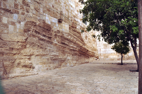
At the northwest corner of the Temple Mount, a rockscarp can be seen in the west wall, north of the Bab al-Ghawanima. This western rocky wall that forms a corner with the northern rockscarp on which the Umariyya School is located, stands to a height of 32 feet (9.75 m).
The west scarp of the Antonia Fortress.
These vertical rockscarps once formed the base for the Antonia Fortress that Herod built here. They show the considerable portion of the mountain he must have cut away to create a platform for a fortress that, according to Josephus, was a “guard to the Temple”.
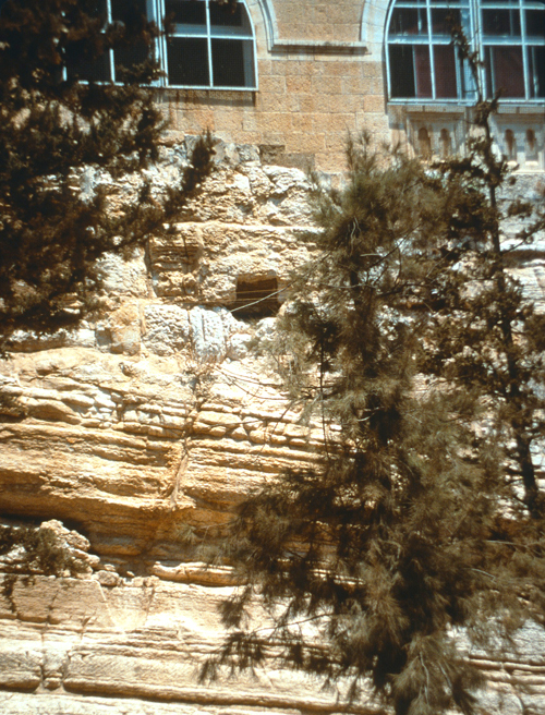
South elevation of the Antonia rockscarp. Some of the sockets for the beams of the Herodian portico can still be seen in between the trees. The three lower arches of al-Isardiyya have been blocked off by walls, obscuring the view of the Antonia rockscarpOne of the sockets for inserting the roof beams of the northern portico. Photo: Leen Ritmeyer
Behind the Ghawanima minaret, the rock is set back a little from the line of the northern wall of the Temple Mount. It is most likely that here, in the Herodian period, a staircase led up to the roof where the north and west porticoes joined.
Plan of the northwest corner of the Temple Mount, indicating the Herodian walls. The Ghawanima minaret is built in the re-entrant angle of the temple Mount. Plan after Michael Burgoyne.
This is the only place from which the fortress could have been entered from the mount. Seeing these remains before us helps us to imagine the momentous events that took place here on the Herodian Temple Mount of Jerusalem.