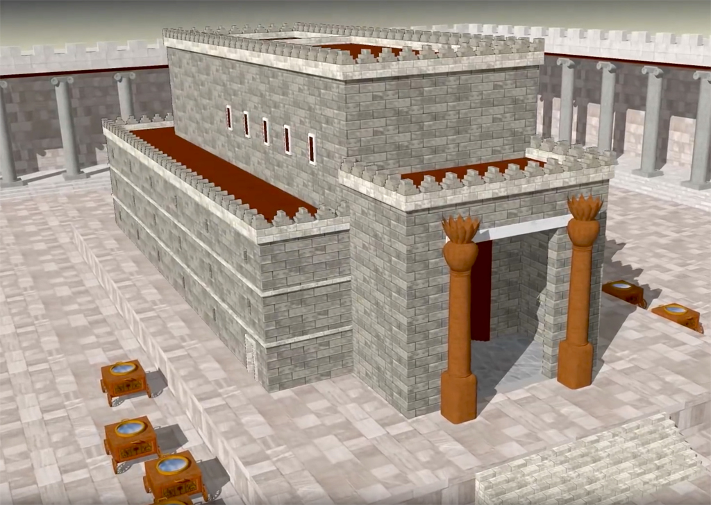
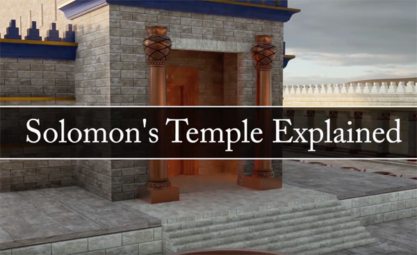
Just over two years ago, I wrote a post, reporting on a 3D model of Solomon’s Temple, created by Daniel Smith. Last week he told me that he had just released a new video, which is called “Solomon’s Temple Explained”. He is happy for me to share it with you.
Solomon’s Temple stood in Jerusalem for almost 400 years. It was the crown jewel of Jerusalem, and the center of worship to the Lord. Understanding the significance of its location, history, and design can greatly add to one’s reverence for one of the most holy places in the world,
Special thanks to: Brian Olson for the beautiful 3D Solomon Temple renders. Michael Lyon for his design elements and feedback of the Temple model. Leen Ritmeyer for his excellent books and personal help. Cantorum Chamber Choir for allowing me to use their music.
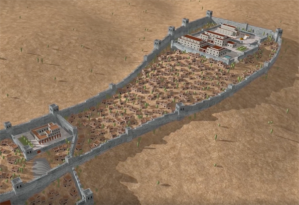
This excellent new video begins by explaining the topography of Jerusalem and how the City of Solomon’s location was determined by the surrounding mountains and valleys. The topographical and biblical importance of Mount Moriah is explained.
The expansion of the City of Jerusalem in the time Solomon.
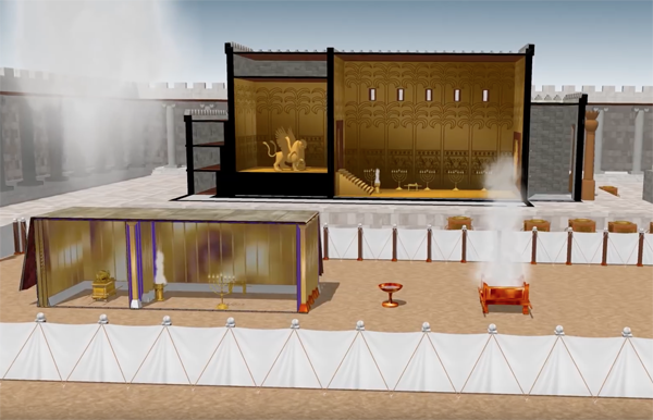
The video includes a section on the Tabernacle which served as a blueprint for Solomon’s Temple. After showing that Solomon built the Temple on Mount Moriah where David previously had purchased the threshingfloor of Araunah the Jebusite, he goes back to the Book of Genesis and explains the symbology of the events that took place in the Garden of Eden.
The design of Solomon’s Temple was based on the Tabernacle, shown here in the foreground.
The video then shows that Solomon’s Temple replicated the same three-level progression as found in the Garden of Eden and the Tabernacle. The ultimate aim of its design was to show how people could return to God. The video ends with the Sacrifice of Christ.
One of my readers, Daniel Wright, commented on my previous blog: “Once again Leen, I would like to thank you for addressing the persistent “temple location” confusion. I frequently get questioned as to my point of view on the “City of David” location theory. Directing the inquisitive to your blog is a real asset. It is important and useful to remind readers that you worked directly for Dr. Benjamin Mazar and you were also a contemporary of Ernest L. Martin, as both of you were there in Jerusalem during the same timeframe. Your personal involvement with Mazar’s team as these things were discovered, and your role as archaeological illustrator make you a primary authority on this topic. I am grateful that you continue to publish materials that address this needless controversy.”
Thanks, for the encouragement Daniel. As promised, I now hope to deal with yet another aspect of the Temple Mount that proponents of the City of David location often bring up in support of their theory, i.e. the Antonia Fortress.
These theorisers have a problem with the existing walls of the Temple Mount and have therefore suggested that they must have belonged to the Antonia Fortress that stood north of the Temple. Such a suggestion shows ignorance of and contradicts the historical sources and archaeological evidence. Let’s begin with the historical sources. Continue reading “The Antonia Fortress”
How a Hebrew inscription blasts the Temple Mount deniers
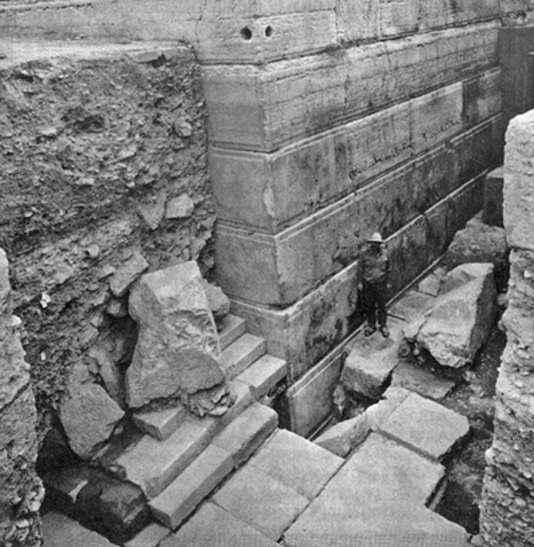
One of the most interesting and important discoveries at the Temple Mount Excavations directed from 1968 till 1978 by the late Prof. Benjamin Mazar, was made at the southwest corner in 1969. After digging through Umayyad, Byzantine and Roman destruction levels, a large corner parapet stone was found lying on its side on the paving stones of the Herodian street, about 1.5 meter (5 feet) from the southwest corner. A niche was cut out of the inner slope of the stone on its southern side. Above this niche was an inscription written in Hebrew, which reads (from right to left) “l’bet hatqia l’hakh . . . ”
The first two words “l’bet hatqia” mean “to the place of trumpeting,” but the last Hebrew word is incomplete. Scholars have suggested completing the inscription with l’hekhal (to the Temple), l’ha-kohn (for the priest) or “l’hakhriz,” (announce). The latter suggestion, which would make the inscription read, “to the place of trumpeting to announce”, has the most support.
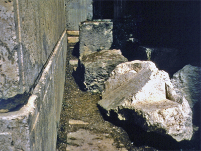
As it was found lying directly on the street and underneath other fallen Herodian stones, it must originally have been located at the top of the southwest corner whence it was the first stone to have been thrown down.
The original location where the Trumpeting Stone was found. Archaeologist Ron Gardiner stands next to the stone.This photo, taken by Leen Ritmeyer in 1973, shows the place where the Trumpeting Stone was found. It was later moved a couple of meters to the west and put the right way up, so that visitors can better appreciate this special find. The original inscription is in the Israel Museum and a facsimile put in its place .
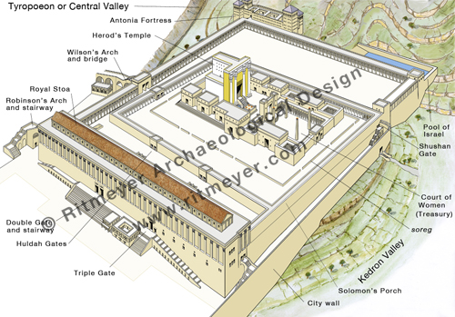
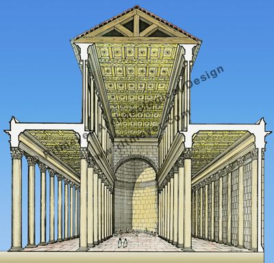
During the Herodian period, a colonnaded hall, known as the Royal Stoa, graced the whole length of the Southern Wall. Constructed in the shape of a basilica with four rows of forty columns each, it formed a central nave in the east end and two side aisles. The central apse was the place of meeting for the Sanhedrin, the supreme Jewish Council. The main part of this building was used for the changing of money and purchase of sacrificial animals.
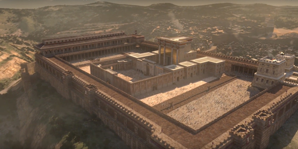
In 19 BC King Herod the Great, began the most ambitious building project of his life, the rebuilding of the Temple in lavish style. To facilitate this, he undertook a further expansion of the Hasmonean Temple Mount by extending it on three sides, to the north, west and south. The Royal Stoa stood above the Southern Wall, on the left of the drawing.
Although the existence and location of this magnificent building was never doubted, questions remain about its plan and decoration. I was pleased therefore to hear of Dr. Orit Peleg-Barkat’s new publication, “Herodian Architectural Decoration and King Herod’s Royal Portico,” that appears in Qedem 57, edited by Eilat Mazar, The Temple Mount Excavations in Jerusalem, 1968–1978 Directed by Benjamin Mazar Final Reports Volume V.Continue reading “The Royal Stoa of the Temple Mount in Jerusalem”
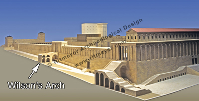
The Israel Antiquities Authority and The Western Wall Heritage Foundation made an important announcement today, reporting the discovery of the remains of a small Roman theatre or odeon in Jerusalem, just below Wilson’s Arch. This report includes a video in English. The Jerusalem Post also reports this find.
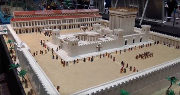
I have seen many models of the Temple Mount and designed some myself, but I have never seen a model made of Lego bricks. Joshua Hanlon made his model of the Second Temple of Jerusalem which is on display at Brickworld Fort Wayne 2016:
Carta, the well-known Jerusalem publishers, offers an introductory price on our latest, and eighth, Carta book, valid until June 30, 2017 (make sure to put in the discount code: “25-off”):
Two new apps have been developed to help visitors visualize ancient Jerusalem, including the Temple Mount. The BYU has developed a free app, which can be downloaded here.
The Virtual New Testament app is one of the most accurate digital recreations of first-century Jerusalem. It’s purpose is to enhance scripture study by allowing you to experience the city, engage with the environment, and immerse yourself in the world of Jesus’ mortal ministry.
This app works for both Mac and Windows desktops and can be downloaded for mobile devices at the Apple App Store or at Google Play.
The Jewish News Online reported on another app that was developed by Lithodomos VR. This app only costs a couple of dollars and is worth getting if you have a Virtual Reality headset. An introduction can also be viewed on YouTube.
Young and old alike now have the chance to wander the streets of ancient Jerusalem, after archaeologists recreated the city at the time of King Herod in a virtual reality headset.
Half a million pounds of investor funding helped created the Android app, called Lithodomos VR, based on the archaeology of Temple Mount in 20BC, before it was destroyed some 90 years later.
The app (at £1.59 or S2.00) and headset let the user experience market streets, the Western Wall, the temple precinct, and the Jewish and Roman period districts, with buildings virtually reconstructed based on the latest archaeological evidence.
On Sunday, the 10th of April, 2017, the Jewish people begin celebrating Pesach – Jewish Passover. That is one week earlier than Easter. However, in this blog post we would like to remember the time that Jesus as a twelve-year-old visited the Temple during Passover for the first time in his life.
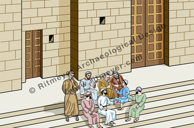
Reconstruction drawing showing young Jesus (in blue) on the steps of the Temple Terrace (ḥel) with the rabbis.
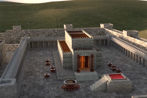
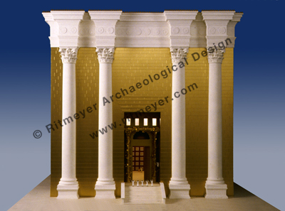
The Temple in the time of Christ was a magnificent building. From the Temple Court (azarah), 12 steps led up to the Porch that was as high as the Temple itself. In front of the entrance to the Sanctuary, a Golden Vine was attached to four columns.
According to Josephus, Herod’s Temple looked like a snow-clad mountain, for all that was not overlaid with gold was of the purest white and it lacked nothing that could astound either mind or eye. No wonder that some of Jesus’ disciples remarked “how the Temple was adorned with beautiful stones and with gifts dedicated to God” (Matthew 24.1; Luke 21.5).
The central feature of this complex, the Holy of Holies, was located deep inside, at the west end of the Sanctuary. No one could enter this place of utmost sanctity but the High Priest once a year on the Day of Atonement. A veil separated the Holy of Holies from a place of lesser sanctity, the Holy Place.
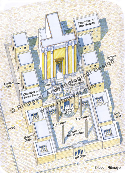
The Temple Court lay in front of the Temple and it contained the Altar, the Laver and the Place of Slaughtering (or Shambles). This was the closest court to the Temple and out of bounds to anyone like Jesus who was not a priest.
This reconstruction drawing shows the Temple, viewed from the east. It was surrounded by a court, called the Temple Court or azarah in Hebrew. In front of the Temple stood the Altar, the Laver (Basin) and the pillars and tables that were used in the preparation of sacrifices. Several gates and other buildings stood to the north and south of the Temple.
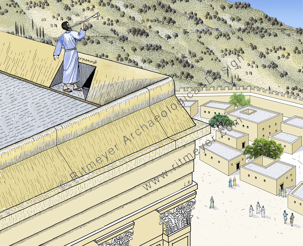
This Temple Court was separated by the Nicanor Gate from the Court of Women, which lay to the east of the Temple. Buildings, called gates, surrounded this complex. In front of the gates was a terrace (ḥel – pronounced chel with the “ch” sounding guttural as in the Scottish “loch”) of 10 cubits wide, which was reached by a flight of steps of half a cubit high and deep. This terrace bounded the wall of the gate buildings on their southern, western and northern sides.
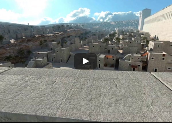
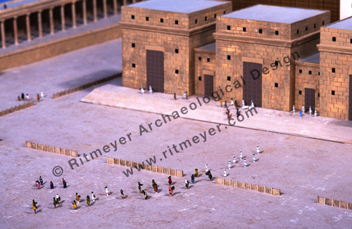
Reconstruction model of the Temple Mount, showing the southern terrace (ḥel). The little blue figure at middle right represents young Jesus.
It is on this ḥelthat we get our first glimpse of Jesus after the birth narratives in the Gospels. Scripture is silent about his youth although it is clear from the observations of nature and Biblical history later attributed to him by the Gospel writers that he absorbed every spiritual and historical lesson that was provided by his upbringing in the countryside around Nazareth.
Now he was twelve years of age and his first words are recorded for us (Luke 2. 41-52). Under the law, attendance at the feasts in Jerusalem was obligatory for boys from the age of thirteen, a birthday that was a milestone in the life of a Jewish boy, when they became a Son of the Commandment or Bar Mitzvah. In practice, this legal age was pushed forward by one or two years so that Jesus, after he had passed his twelfth year, came up to Jerusalem for the Passover with his family. Jesus’ first view of the Temple must have filled him with a great sense of the purpose he had been developing during the quiet years in Nazareth. Attendance at the Temple was obligatory only for the first two days of Passover, after which many of the pilgrims would have returned home again. It would appear that Joseph and Mary and their “company” did indeed start to return home and had travelled for a day. When they finally realized that Jesus was missing, it took them three days to find him and when they did, he was “in the temple, sitting in the midst of the doctors, both hearing them and asking them questions.” The ḥel is the only place in the Temple he could have been.
We learn this from a tractate of the Babylonian Talmud, Sanhedrin 88b, which tells us:
“It has been taught; R. Jose said; Originally there were not many disputes in Israel, but one Beth din of seventy-one members sat in the Hall of Hewn Stones, and two courts of twenty-three sat, one at the entrance of the Temple Mount and one at the door of the [Temple] Court, and other courts of twenty-three sat in all Jewish cities.” “The Great Sanhedrin] sat from the morning tamid (daily sacrifice) until the evening tamid [in the Hall of Hewn Stones]; on Sabbaths and festivals they sat within the ḥel.”
So, Passover would have been one such festival when members of the Temple Sanhedrin would come out to teach in this area. Ordinary people, who normally had no access to the classrooms where young priests were taught, could come and question them. Jesus must have eagerly made use of this opportunity and never would they have had such a sharp student as him. During this visit to the Temple, he would have seen the preparations for sacrificing the Passover lambs and realized, perhaps for the first time in his young life, that the entire ritual pointed forward to his own sacrifice. He would have been so absorbed by all these experiences that he would not have wanted to leave. He forgot about his natural family, for here he was at home – in his Father’s house.
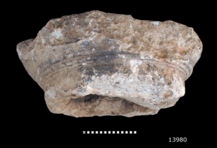
The Israel Hayom newspaper reported yesterday that a capital of the 2nd Temple era has been found by the Temple Mount Sifting Project (TMSP).
Photo credit: Vladimir Naychin
The capital of a carefully-adorned column that stood on the Temple Mount in the time of the Second Temple has been discovered through the Temple Mount Sifting Project.
The capital, whose size indicates that the column had a circumference of 75 centimeters (30 inches) at its top, is a section of one column that formed part of the double colonnade that surrounded the Temple Mount plaza.
Dr. Gabriel Barkay, the director of the Temple Mount Sifting Project, said that “this is a capital in the Doric style, one of the characteristics of the art in the time of the Hasmonean dynasty. This appears to be the capital of a column formed part of the eastern colonnade of the Temple Mount, which Josephus and even the New Testament called ‘Solomon’s Porch.’ A column like this is impressive testimony of the immensity of the structures on the Temple Mount in the Second Temple era, and fits in well with Josephus’ narrative, which describes what he saw with his own eyes.”
Barkay explained that a 25-cubit column would have stood 12.5 meters (41 feet) high.
It is of course wonderful news that a capital of a column that most likely stood on the Temple Mount was found. I would agree with Barkay that the capital could have belonged to one of the columns that formed the eastern Hasmonean (pre-Herodian) colonnade. This colonnade was indeed known as Solomon’s Porch, where Jesus walked during Hanukkah (John 10.23). It was also the place where Peter and John healed the blind man (Acts 3.11) and where the apostles did many signs (Acts 5.12).
One must, however, be careful with dimensions. In the article it says that the circumference of the Doric column that supported the capital was 75 cm. That is probably a mistake. According to simple mathematics, a column with a circumference of 75 cm (30 inches) has a diameter of less than 24cm (9 inches). In ancient architecture, Doric columns had a 1:8 ratio between diameter and height. According to that rule, this column could not have been higher than 2m (6 feet, 6 inches), which would not have been exactly monumental. Barkay therefore probably meant that the column had a diameter of 75cm. In that case, the column would have been about 6m (20 feet, 11.4 cubits) high. Barkay estimated that a 25-cubit column would have stood 12.5 meters (41 feet) high, but this one would have much smaller, about half the size.
An additional problem is the use of units of measurement by Josephus. In War, he uses cubits and in Antiquities (Roman) feet. As a rule, his measurements in feet are more accurate than those in cubits, which are often exaggerated.
Josephus writes in War 5.190-192, that the columns of the Herodian porticoes were 25 cubits, which according to the Royal Cubit of 52.5 cm (20.67 inches), would be 13.12m, (43 feet) high, but in Ant. 15.413 he says that the columns of the porticoes were 27 feet high (8.23m, 15.67 cubits). Let us first look at the 25 cubits high columns and then at those of 27 feet high.
According to the Doric ratio of diameter and height, the diameter of a 25 cubit high Doric column must have been 1.64m (5 feet, 5 inches). Archaeological remains of parts of such thick columns have been found in secondary use in the Temple Mount excavations in front of a gate of an Umayyad palace. A complete column with a diameter of 1.46m (4 feet, 9 inches) has been preserved in the Double Gate underground passageway. Josephus mentions in Ant. 15.415 that the height of the Corinthian columns (which have a ratio of 1:10) of the Royal Stoa were 50 feet (15.24m or 29 cubits) high, probably including the capitals. This measurement is somewhat similar to the 25 cubits high columns of War 5.190-192 and must therefore relate to the columns of the Royal Stoa and not to those of the porticoes. Columns of that height could only have belonged to the Royal Stoa.
A north-south section through the Royal Stoa that stood at the southern end of Herod’s Temple Mount. The Royal Stoa was the largest structure on the Temple Mount and was built in the style of a basilica. It had a central nave and two side aisles with four rows of 40 columns. Josephus calls this stoa more deserving of mention than any structure under the sun.
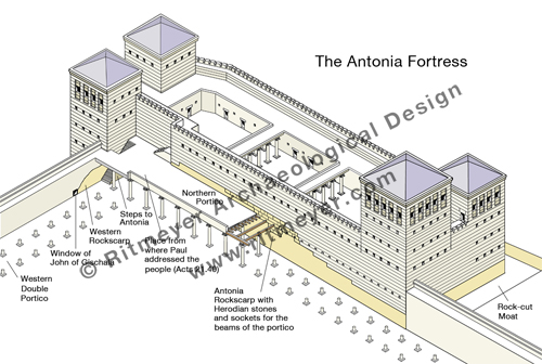
Going back to Ant. 15.413, where Josephus writes that the columns of the porticoes were 27 feet (8.23m) high, we found that this measurement is indeed correct for the Herodian porticoes. The preserved sockets of the northern portico can still be seen in the south wall of the Antonia Fortress (see drawing). They are located 8.84m (29 feet) above ground level. As the beams that were laid on top of the capitals were fixed in these sockets, Josephus’ measurement of 27 feet appears to be accurate.
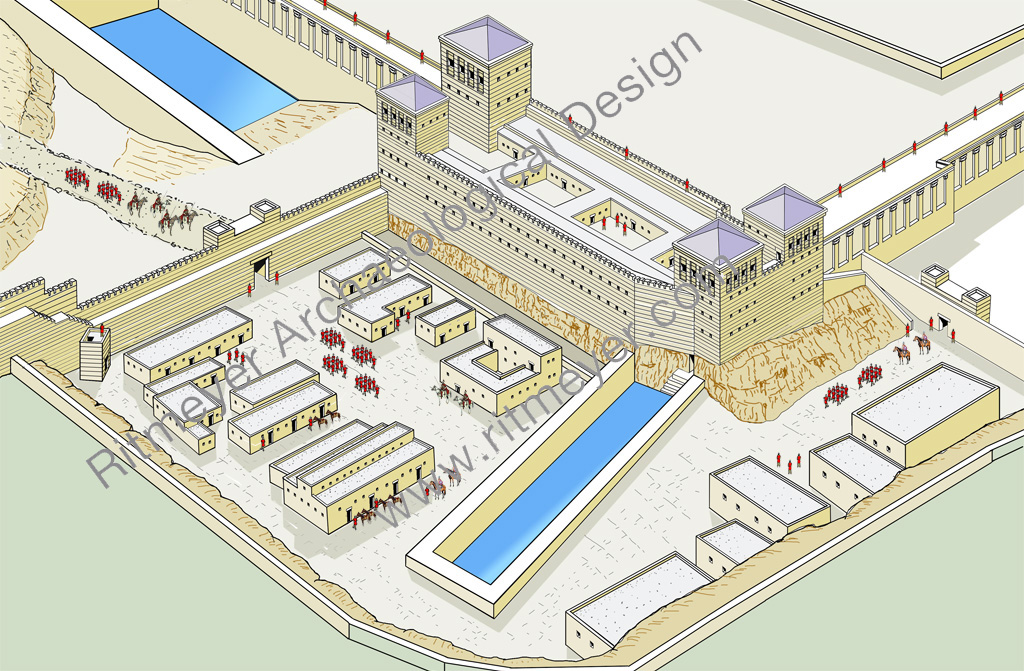
The Antonia Fortress that stood at the northwest corner of the Herodian Temple Mopunt had four towers, three of which were 50 cubits (86 ft./26.25 m) high and the fourth, the southeast tower, 70 cubits (120 ft./36.75 m) high. The view from this highest tower, that, according to Josephus “commanded a view of the whole area of the Temple” (War 5.242), must have been spectacular. The location of the sockets for the northern portico are indicated in the drawing.
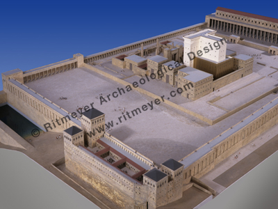
The reconstructed height of the newly found Hasmonean column of 6m (20 feet) is a little lower than those of the Herodian columns. The older Hasmonean portico, also known as “Solomon’s Porch”, was apparently not as high as the Herodian colonnades, as indicated in this reconstruction model.
An overall view of a model of the Temple Mount looking from the northwest. In the foreground is the Antonia Fortress, while the Temple with its surrounding buildings stood close to the centre of the Temple Mount. The lower portico above the Eastern Wall (upper centre) was known as Solomon’s Porch.