The Western Wall was not destroyed by an earthquake!

Walking on the Herodian street alongside the Western Wall in the Jerusalem Archaeological Garden and Davidson Centre, one sees an enormous pile of Herodian stones that clearly came from higher up the wall. The excavations in this area by the late Benjamin Mazar and later by Ronnie Reich have proved without a doubt that this destruction occurred in 70AD. The Herodian stones fell on a thin layer of destruction debris that contained many Herodian coins.
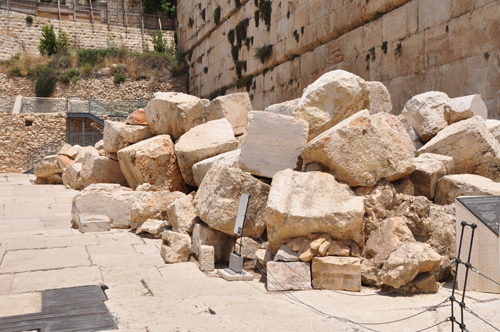
Herodian stones lying on the Herodian street, dating from the Roman destruction in 70AD. Photo: Leen Ritmeyer

As reported first in Haaretz newspaper (in the Premium section which is available to subscribers only, but which was kindly forwarded by email to me by Joe Lauer) and later elsewhere, this view is now challenged by Shimon Gibson, who claims that these stones were destroyed by an earthquake that took place in 363 AD.

He reasons that a Roman bakery that was uncovered by Benjamin Mazar and published by his granddaughter Eilat, would not have been built next to a ruin.

“Who would buy bread in a place with damaged walls above it and fallen stones [adjacent to it]? You don’t build next to a four-story ruin.”

Obviously, people did build next to the four-story high Western Wall, as both the bakery and the Western Wall are still standing there today! We need to remember that the Temple Mount became a symbol of Jewish rebellion against Rome and therefore it was deliberately left in ruins.
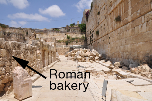
The eastern wall of the Roman bakery that was built next to the pier of Robinson’s Arch in the Western Wall and at the level of the Herodian street. Photo: Leen Ritmeyer.

“Now we know much more about the late Roman period. If there was a neighborhood like this there, how could it be that they leave debris from the year 70 CE in the middle of it all? It’s like going out of your house and leaving a pile of debris. You clear it.”

Mount Moriah in the time of Aelia Capitolina. The bakery is at the southwest corner (left in the drawing).

Well, that is easier said than done, as these stones were very heavy and difficult to move. Some stones were moved, but only for monumental building activities, such as the Damascus Gate, which was been partly built with Herodian stones in secondary use, and other projects such as the Nea Church and the Umayyad buildings. For smaller projects, such as dwellings, these Herodian stones were cut into smaller stones that were easier to handle.

The Damascus Gate is located in the centre of the northern wall of the Old City of Jerusalem. The gate was built in the 2nd century AD during the reign of the Roman Emperor Hadrian as a monumental entrance to the city of Jerusalem, which he had renamed Aelia Capitiolina.

Additionally, as we will see below, there was no heavy stone debris where the bakery was built. The bakery was also not located next to the main Roman street in this area, called the Lower Cardo, but on a street of secondary importance, some distance away from it.

After the Roman destruction of 70 A.D., the 10th Legion set up an encampment south of the Hippicus Tower on the Western Hill of Jerusalem. After nationalistic uprisings, Hadrian flattened the city and in 135 A.D. built a new one on its ruins and called it Aelia Capitolina. The major buildings are the Damascus Gate in the north, a Temple of Aphrodite, two forums (market places) and there may have been a Temple of Jupiter on the Temple Mount.

“Gibson believes the builders of these structures used the still-existing Temple Mount walls and imitated their architecture and design as an effort by the Church to show that it – not rabbinic Judaism – was the anointed successor to Temple Judaism.”

A close examination of these structures, however, shows that the Herodian stones in these buildings are in secondary use. They were taken from the Temple Mount wall and moved there.

Before making sweeping statements, one should carefully examine the evidence. What kind of “large building stones” do visitors today see lying on the Herodian street?  Among the rectangular stones there are many pilaster stones that were toppled down from the upper part of the Western Wall where the western portico stood.
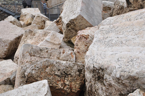
Pilaster stones that came from the upper part of the Western Wall can be seen among the Roman destruction stones. Photo” Leen Ritmeyer

Josephus records that during the struggle for the Temple Mount, these porticoes were burnt and destroyed (War 6.191). The timber beams would have caught fire, the roof was destroyed and the pillars probably fell down on the Temple Mount, leaving only the outer wall, with its pilasters, standing. This upper part of the wall was pushed down by the Romans and fell on the street below, which was covered with a layer of burnt debris containing coins of the Jewish Revolt. Gibson‘s argument that these coins may have been deposited below these stones at a later date, goes against all archaeological logic.

The destroyed stones on the Herodian street were found in front of the pier of Robinson’s Arch as far as the northern edge of the excavations below the Mughrabi Gate ramp which leads up to the Temple Mount, but not south of this point.

Destruction stones in front of the pier of Robinson’s Arch. Photo: Leen Ritmeyer 1973.

No such quantity of stones was found near the southwest corner where the Roman bakery was found.
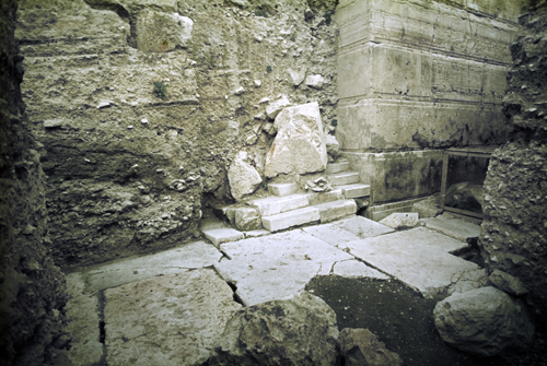
The southwest corner of the Temple Mount before the rest of the street was excavated by Ronnie Reich. As can be seen from the section, which is close to the Roman bakery, only a couple of large Herodian stones were found on the Herodian pavement. The Trumpeting Stone, as it was found, is visible at the right of the picture within a protective frame. Photo: Leen Ritmeyer 1973.

So, the bakery was not built in the middle of a pile of Herodian stones, as Gibson tries to infer that people believe. Of course, some rubble must have been cleared, but no gigantic mound of stones. That is clear also when one looks up. The Herodian southwest corner, as all other corners of the Herodian Temple Mount, has been preserved to a great height. Only the Trumpeting Stone and a few others were found here lying on the street.

Earthquakes can cause a lot of damage, as happened in 1927 when the al-Aqsa Mosque was almost entirely destroyed. But there is no evidence that an earthquake at any time ever dislodged stones from these massive 5m (15 feet) thick Herodian retaining walls. If the earthquake of 363 AD did destroy the Western Wall, where is the evidence? The heap of fallen Herodian stones is only three meters (10 feet) high. No stones were ever added on top of this, as this Roman destruction was covered by a late Roman bath house and Byzantine street level and drain. The Roman floor level was later covered over by the floor of an Umayyad palace. If the Western Wall was destroyed in 363 AD, then a large pile of stones would have been found on top of the Roman bath house and Byzantine street level which would have been completely destroyed, but no sign of this was found.
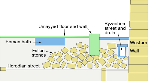
This sectional drawing shows the Herodian destruction stones lying on the Herodian street next the the Western Wall (yellow). The Roman bath house and Byzantine drain (blue) was built over this destruction layer. In iturn, the Roman and Byzantine levels were covered by an Umayyad Palace. © Leen Ritmeyer

It is no wonder that “Gibson’s theory has been vehemently rejected by many.” Happily he said: “If I am wrong, then I am wrong. Life will go on.” I wish him all the best for the new year but think it unlikely that his proposal will cause an earthquake in how we understand this, one of the most significant and moving discoveries of the Temple Mount Excavations.

HT: Joe Lauer
Where on the Temple Mount was Jesus during Hanukkah?

There are some unique locations in the Land of the Bible where you really get a sense of place. One  of these is inside the Eastern Wall of the Temple Mount in Jerusalem. Here the record of Jesus’ visit to the Temple precincts in John 10.22-39 comes to vibrant life. We are told:

And it was the feast of the dedication at Jerusalem: it was winter; and Jesus was walking in the Temple in Solomon’s Porch (John 10:22,23).

Jesus had come to keep Hanukkah, the Feast of Lights. This feast commemorates the dedication of the Temple in 164 BC, after it had been defiled by Antiochus IV Epiphanes, who, three years earlier, had ordered a pig to be sacrificed on the Temple altar.

But why does this place evoke the Gospel story so powerfully? It is surely because this side of the Temple Mount is closest to the original, with minimal additional construction. The Eastern Wall of the Temple Mount was the only one that was not moved by King Herod the Great when he carried out his monumental expansion of the Temple Mount in the first century.

At present there are no porticoes along the Eastern and Southern Walls of the Temple Mount. In the Herodian period, however, there were porticoes on all sides. The eastern stoa pre-dated the others and was already colonnaded in the Hasmonean period. This Porch, or stoa, stood directly over the wall of the earlier square Temple Mount and at the time of Herod the Great, was known as Solomon’s Porch.

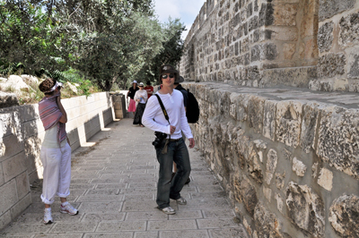
Walking on the Temple Mount along the inside of the Eastern Wall, looking north.
Standing here on the inside of the Eastern Wall (looking south), we can imagine Jesus speaking with his disciples, while around them in the Temple precincts, the people celebrated God’s intervention in their place of worship.
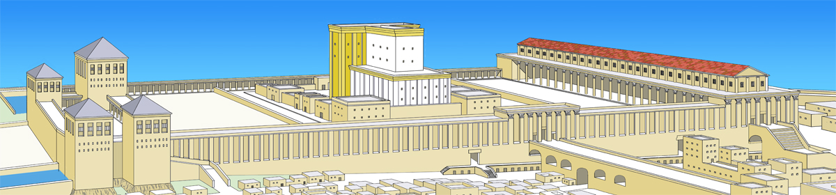
An overall view of a model of the Temple Mount looking from the northwest. In the foreground is the Antonia Fortress, while the Temple with its surrounding buildings stood close to the centre of the Temple Mount. The lower portico above the Eastern Wall (upper centre) was known as Solomon’s Porch, mentioned in John 10.23 and Acts 3.11; 5.12.

This does not necessarily mean that this porch was built by this famous king, but certainly by Herod’s predecessors. Offering welcome shelter from sun, wind and rain, it was obviously used as a place of congregation. Josephus provides us with an evocative description:

The porticoes, all in double rows, were supported by columns five and twenty cubits high—each a single block of the purest white marble—and ceiled with panels of cedar. The natural magnificence of these columns, their excellent polish and fine adjustment presented a striking spectacle. (War 5.190–192)

It was here that Jesus was almost stoned one wintry day during the feast of Hanukkah (John 10.31). Acts 3.11 and 5.12 also provide us with images of the time when the disciples used to congregate and teach here after the death of their master.

Postscript: During this feast, a Hanukkiah is lit, but what is the difference between a Hanukkiah and a Menorah (Lampstand)?

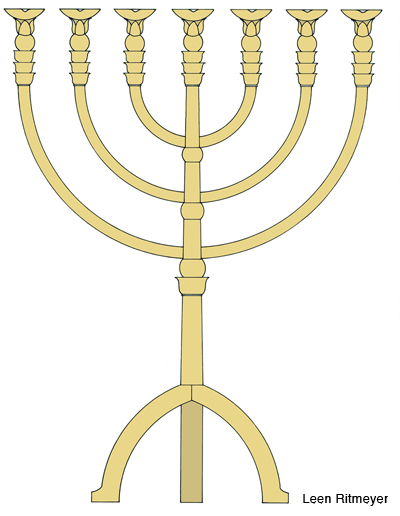
The Temple Menorah is a Lampstand with seven branches.
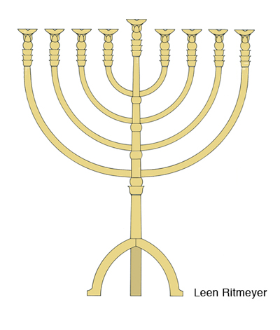
A Hanukkiah has eight branches, representing the eight nights that oil miraculously burned in the Temple. The lamp on the central ninth branch, which is called the shamash, is used to light the others.


Bethlehem – the Manger and the Inn

People have asked me where I think Jesus was born. I reply that Scripture and archaeology show that the place was not a randomly chosen cave in Bethlehem, but a location that was prepared centuries earlier for this purpose.

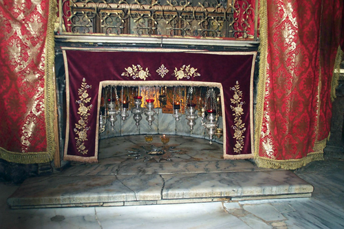
The Cave in the Church of the Nativity in Bethlehem, with the silver star indicating the place where, according to Byzantine tradition, Jesus was born.

According to Luke 2.1-5, Mary and Joseph had to travel to their own city. It must have been an uncomfortable journey when Mary was almost 9 months pregnant and had to travel, probably on the back of a donkey, from Nazareth to Bethlehem – a 100 mile long journey through the Jordan Valley! On arriving in Bethlehem, they couldn’t find a place to stay. The only available place for the Son of God to be born was a dirty stable, which had to be shared with animals. It wasn’t a romantic Christmas postcard stable with smiling camels and donkeys, probably drawn by artists who don’t know how bad camels can smell and how loud the braying of donkeys can be!

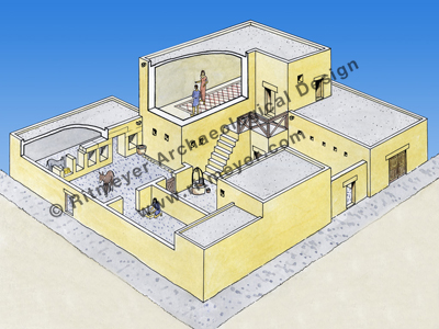
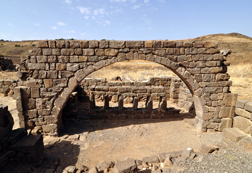
What actually did a stable look like in the time of Christ? From archaeology we know that stables looked like rooms with a fenestrated wall, i.e. an interior or exterior wall with several low windows. Animals were placed behind this wall and fodder was put in wooden boxes or baskets and placed in the windows. Sacks of provender were stored in the other half of the room. It was probably in this part of the stable that Mary and Joseph were allowed to stay and where Jesus was born. Fenestrated walls that were part of stables have been found in many places, such as Capernaum and Chorazin that are illustrated here.

A reconstruction drawing of a typical house in Capernaum from the time of Christ. The rooms of the house were located round a central courtyard, which had a water cistern. The main living quarters were upstairs, while other rooms were used for storage and work. Animals were kept overnight behind a fenestrated wall (portrayed on the left).


The remains of a stable in Chorazin. The animals were kept behind the fenestrated wall. Animal fodder and other provender was kept on this side of the wall. Photo: Leen Ritmeyer

But, what is the importance of Bethlehem and which inn was chosen by God as the place for His son to be born in?

When Joshua conquered Jericho, he cursed the city, so that it became a city of death. Rahab was the only person, with her family, that was saved. She married Salmon and their son was called Boaz, who must have settled in Bethlehem when Judah captured its inheritance. Boaz married Ruth in Bethlehem and she became the great-grandmother of David (Ruth 4.10). Gentile Ruth was, of course, one of these amazing few women mentioned in the genealogy of Jesus in Matthew Ch. 1. King David was born in Bethlehem and anointed king there by Samuel the Prophet.

Near the end of his life, David had to flee from his son Absalom, when he rebelled against him. He stayed with the aged Barzilai the Gileadite, whose son Chimham returned with David to Jerusalem (2 Sam. 19.37-40). To provide him with a source of income, it appears that David may have given him part of his own inheritance in Bethlehem to build an inn (mentioned in the early Jewish source, Targum Yerushalmi, Jer. 41.17a), and called  “Geruth Chimham” “Habitation of Chimham” (Jer. 41.17). As small towns like Bethlehem usually had only one inn, it is reasonable to suggest that Jesus may have been born in this inn. Through the generosity of David to Barzilai and his son Chimham, a birthplace for Jesus was prepared.

A typical inn with buildings arranged round a courtyard. © Leen Ritmeyer

The fact that Jesus could be born in his own inheritance as the true Son of David is another one of the wonderful topographic coincidences that run through the whole plan of the Bible.

The Temple Mount during the Byzantine period (324-638 AD)

The Byzantine period is the next period we look at in this Temple Mount series. Up until recently, it was thought that the Temple Mount lay desolate during this time and was used as the city’s garbage dump. However, this may not be altogether accurate.

In 324 AD, the Emperor Constantine the First made Christianity the official religion of the Empire and together with his mother, Queen Helena, consecrated sites in the Holy Land associated with the life of Jesus. In Jerusalem, the Church of the Holy Sepulchre was built on the site assumed to have been the burial place of Christ. It was the first and only time during Jerusalem’s long history that the focus of the city was shifted away from the Temple Mount to this newly built church, effectively denying any Jewish connection with the city.

The Temple Mount during the Byzantine period. Remains of houses have been found at the southern end of the platform, near the exit of the Double Gate tunnel. At the southeast corner, a chapel which contained  the so-called Cradle of Jesus can be seen.

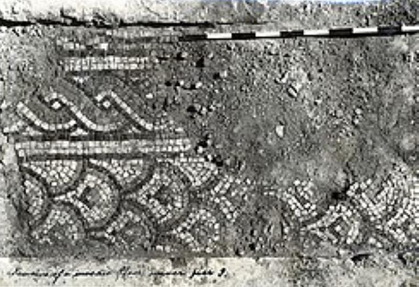
However, the reported finding of part of a Byzantine mosaic floor under the al-Aqsa Mosque in excavations carried out here in the 1930s (the only time that such activity was allowed on the Mount), points to the possible existence of houses at the southern part of the Mount during the Byzantine period.

Part of a mosaic floor found beneath the al-Aqsa.
(photo credit: Courtesy of Israel Antiquities Authority.)

Regrettably, the limited finds make it impossible to draw any firm conclusions as to the extent of the built-up area.

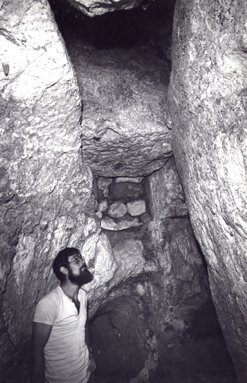
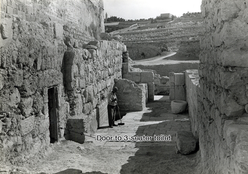
There are, however, other signs that the southern part of the Temple Mount was used at that time. A large monastery, the so-called Monastery of the Virgin, was excavated near the Triple Gate. In its courtyard, a three-seater toilet was found that was flushed with the water of one of the Temple Mount cisterns, namely Cistern 10.

Deep in the bowels of the Temple Mount, the author examines the inspection tunnel of Cistern 10, at the right of the photo. The descending tunnel is at the centre.

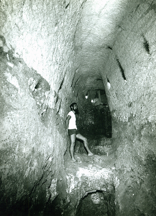
The water from this cistern was led to the monastery through a tunnel that had been carved specially for this purpose.

The rock-hewn underground tunnel that leads down from Cistern 10 to the Monastery of the Virgin.
The courtyard of the Monastery of the Virgin near the Triple Gate. The doorway on the left leads into a small chamber which had room for three people to sit on a marble bench that had slits above a drainage channel.

Finally, on the inside of the southeast corner of the Temple Mount that has been preserved to a great height, is the chapel of the so-called Cradle of Jesus (Arabic: Sidna Issa). There is a small  shrine inside this room. The photo below shows the small Muslim dome that was built over a Byzantine altar that has four marble pillars and a reliquary underneath. This may have been the shrine where the nuns of the Monastery of the Virgin came to commemorate the birth of Jesus.

The so-called Cradle of Jesus on the inside of the southeast corner of the Temple Mount.

The reconstruction drawing above is the 9th in this series that was made specially for our new Temple Mount guide book that is awaiting publication. For the previous drawings see: Mount MoriahJebusitesSolomonHezekiahNehemiah, the Hellenistic and Hasmonean periods , the Herodian period and the Roman period.

Harbours of the Sea of Galilee

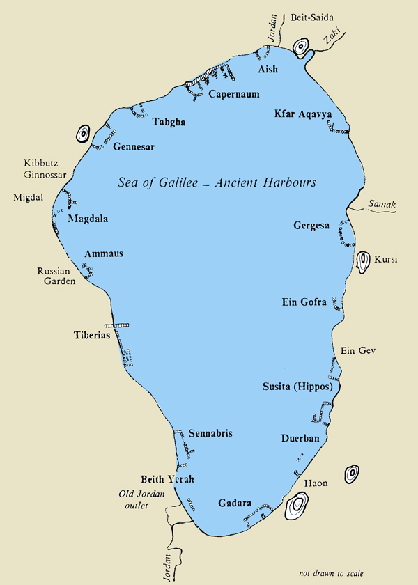
Ferrell Jenkins runs a travel blog and today wrote a post on the Ports of the Sea of Galilee which has some excellent photographs of the Church of the Primacy of Peter at Tabgha. In this interesting post he comments on the work of the late Mendel Nun, who was a member of Kibbutz Ein Gev and worked as a fisherman on the Sea of Galilee. Although not a professional archaeologist, Mendel researched and recorded the remains of the ancient harbours of the Sea of Galilee, of which there were at least sixteen.

The remains of these harbours can only be seen when the water level is low. In the 1970’s, a number of ancient harbours were discovered, followed by the discovery of an ancient fishing boat in the mud near Magdala. During the years of 1989-1991 there was a severe drought and the accompanying archaeological activities revealed many remains that shed light on the shipping trade and fishing industry during the first century.

Here is a map of the harbours that were plotted by Mendel:

A map of the Sea of Galilee showing the remains of ancient harbours.

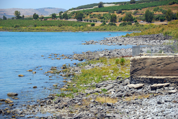
The photograph below, taken in 2009, shows the remains of some of the piers of the Capernaum harbour:

Photo: Leen Ritmeyer

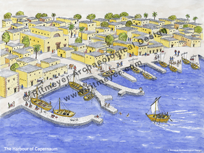
Mendel’s map and the photographs he published made it possible to make a reconstruction drawing of Capernaum and its ancient harbour:

Reconstruction of the harbour of Capernaum at the time of Christ, based on archaeological remains. Several piers, which can still be seen when the water level is low, jutted out into the sea to provide a quiet and safe harbor for fishing boats. Capernaum was the city where Jesus lived after he left Nazareth (Matthew 4.13; Mark 2.1; Luke 4.31; John 2.12).

The Temple Mount during the Roman period

We have now arrived at the Roman period in our sequence of reconstruction drawings showing how the Temple Mount developed over time. After the Roman destruction of Jerusalem in 70. A.D., the area of the Temple Mount lay desolate. In 130 AD, Emperor Hadrian began to build a Roman colony named Aelia Capitolina, on the ruins of Jerusalem.

After the Roman destruction of 70 A.D., the 10th Legion set up an encampment south of the Hippicus Tower on the Western Hill of Jerusalem. After nationalistic uprisings, Hadrian flattened the city and in 135 A.D. built a new one on its ruins and called it Aelia Capitolina. The major buildings in this city were the Damascus Gate in the north, a Temple of Aphrodite, two forums (market places) and there may have been a Temple of Jupiter on the Temple Mount.

The name Aelia was given in honor of the emperor’s family name, which was Aelius, while the name Capitolina honored the deities of the Capitoline triad: Jupiter, Juno and Minerva.

Hadrian’s actions precipitated the Revolt of Bar Kokhba (“Son of a Star”), which began in 132 AD. Some Jews regarded Bar Kokhba as the promised Messiah. Plans were made to rebuild the Temple and coins depicting it were struck. It is unclear how far these plans materialized. Following the suppression of the revolt in 135 AD, the pagan city of Aelia Capitolina became reality. A sanctuary to Jupiter may have been erected on the Temple Mount.

Some historical sources indicate that during this Roman period when Jerusalem was called Aelia Capitolina, a sanctuary to Jupiter was erected on the Temple Mount.

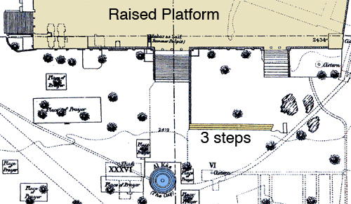
The remains of three long steps that are no longer visible but which were marked on plans made by Sir Charles Warren, may have belonged to the southern part of the crepidoma  (stepped platform) of this presumed temple.

Part of Warren’s Plate 5, showing the location of the 3 long steps south of the Raised Platform where the Dome of the Rock stands and north of al-Kas, a fountain for Muslim ritual washing.

Jews were forbidden from entering the city on pain of death and Hadrian tried further to erase their connection to the Land by changing the name of Judea to Syria Palaestina (whence the name Palestine).

The reconstruction drawing above is the 8th in this series that was made specially for our new Temple Mount guide book that is awaiting publication. For the previous drawings see: Mount MoriahJebusitesSolomonHezekiahNehemiah, the Hellenistic and Hasmonean periods and the Herodian period.

Free App “Dig Quest: Israel” Teaches Children about Archaeology in Israel

The IAA has released a great free app to teach children about the archaeology of Israel. As parents who have always encouraged our children (now grown up and leading their own tours to Israel and the surrounding Bible Lands) to get involved in the fun of digging, we are excited about this development. The app is in English and is available for download at the iTunes Store for iPhones and iPads. An Android version will be made available soon.

The app features two simulated dig sites.  One is based on the site of a Roman period mosaic at Lod and the other on the site associated with the Dead Sea Scrolls at Qumran. These two sites were chosen as they are so well known. Most people have heard of the Dead Sea Scrolls and the beautiful mosaic that was found in Lod is making a world tour of leading museums in the U.S and in Europe. You can learn more about this mosaic at the Lod Mosaic website.

We are delighted that our reconstruction drawing of the Anaploga Villa in Corinth was used in this game:

Reconstruction based on archaeological evidence of a Hellenistic villa excavated at Anaploga in Corinth. Christians may have assembled in such houses to hold religious ceremonies, such as the one mentioned in 1 Corinthians 16.19 and Philemon 2.

The IAA reports further:

The games were developed in collaboration with the IAA’s team of pre-eminent archaeologists and researchers. As they play, kids get a feel for what archaeologists do as they experience the excitement of discovery and the creativity and skills involved in solving mysteries from the distant past.

Players select between two dig sites – each has a unique game that puts the player in the driver’s seat and requires using different archaeological skills. At Lod, you clear the dirt to uncover an ancient Roman period mosaic and then play a fast-paced quiz-style game using your smarts and powers of observation to identify and classify the animals and objects on the mosaic.

In the Qumran caves, you discover fragments of the 2,000 year-old Dead Sea Scrolls that you piece together in a puzzle game. Then you scan the scrolls to reveal their text more clearly, mirroring the advanced spectral imaging process performed by the IAA team in the laboratories.

We look forward to seeing what other sites will eventually be added to the app!

Building violations and illegal construction on the Temple Mount – again!

Shimon Cohen and Tova Dvorin of israelnews.com report that the Jordanian Waqf is assembling a generator on the Temple Mount without permits. This was revealed by architect Gideon Harlap in a special Arutz Sheva interview:

The Jordanian Waqf continues to build illegally on the Temple Mount, photos leaked to Arutz Sheva revealed Wednesday.

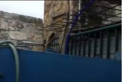
Illegal construction at the northeast corner of the Temple Mount. Photo: meha’olim lehar.

The photos, which were taken by a visitor to the Mount, show what appears to be new construction, under a tarp, in the northeast corner of the Mount.

To clarify whether the Waqf has the license to build on the Mount – and what ramifications there may be if it does not – Arutz Sheva spoke to architect Gideon Charlap, who turned to the licensing and inspection bureau in Jerusalem “to address urgently the building violations and illegal construction on the Temple Mount,” as he put it.

Charlap makes it clear that the pictures shows that the “Waqf is building without a permit from anyone,” and added that its official statements claiming that generators added to the site were provided by the Jordanian King are false.

According to Charlap, the Waqf simply bought the generators from Israel at full price – then added them to the Temple Mount compound without official authorization.

“The power of these generators is huge and disproportionate [to the size of] the Temple Mount,” he added. “They can light up with that half the old city.”

Charlap maintained that the addition of the generators “damages Israeli sovereignty.”

Charlap explains that “anyone who builds these huge generators must comply with safety, fire protection, security, solar and diesel fuel [regulations] etc. I went to all the authorities such as the Ministry of Defense, Ministry of the Home Front Command and more [over it] and now they are trying to create a safety cover but this further undermines the architecture of this holy place.”

“We have to do archaeological excavations here intelligently, without damaging the landscape, without damaging the artifacts,” he continued. “They are not the owners. A landlord can ask for an application for a permit, but they are not the owners – so they cannot apply for a permit at all.”

“The Waqf cannot build what it wants and when it wants,” he added.

Charlap is still waiting for an official response over the issue from Jerusalem, as well as from various government organizations.

The Waqf, which was left in charge of the Temple Mount after Israel liberated it during the 1967 Six Day War, consistently destroys Jewish antiquities on the compound in a direct violation of a ruling by the Supreme Court.

It also regularly builds on the site without a permit. In January, Temple Mount rights activist Yehuda Glick caught officials illegally drilling on the ancient holy site. The drilling was later revealed to have been establishing placeholders for dozens of trash cans.

The Temple Mount in the Herodian period (37 BC-70 AD)

Following on from our previous drawing, the Temple Mount during the Hellenistic and Hasmonean periods, we now examine the Temple Mount during the Herodian period. This was, of course, the Temple that is mentioned in the New Testament.

Herod extended the Hasmonean Temple Mount in three directions: north, west and south. At the northwest corner he built the Antonia Fortress and in the south, the magnificent Royal Stoa.

In 19 BC  the master-builder, King Herod the Great, began the most ambitious building project of his life, the rebuilding of the Temple and the Temple Mount in lavish style. To facilitate this, he undertook a further expansion of the Hasmonean Temple Mount by extending it on three sides, to the north, west and south. Today’s Temple Mount boundaries still reflect this enlargement.

The cutaway drawing below allows us to recap on the development of the Temple Mount so far:

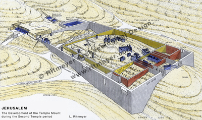
King Solomon built the First Temple on the top of Mount Moriah which is visible in the centre of this drawing. This mountain top can be seen today, inside the Islamic Dome of the Rock. King Hezekiah built a square Temple Mount (yellow walls) around the site of the Temple, which he also renewed. In the Hasmonean period, the square Temple Mount was enlarged to the south (red walls). Finally, King Herod the Great enlarged the mount to double its size (grey walls) by building 15 feet (5 m) thick retaining walls, which are still standing today.
The many cisterns cut into the mountain are also shown.

A visualization of this Temple Mount was made possible by combining the historical sources with the results of archaeological exploration. The main historical source is the first-century historian Josephus Flavius. His works, The Jewish War  and Jewish Antiquities, although prone to exaggeration, are indispensable for this period. Also invaluable is the Mishnah, the earliest code of rabbinic law, written about 200 AD, particularly the Tractate Middot, which deals with measurements. The New Testament adds further detail and context. All this was augmented by the results of the excavations to the south and west of the Temple Mount following the Six-Day War in 1967.

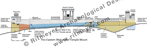
Herod’s extension of the Eastern Wall to the north required the filling in of a deep valley to the north of the pre-Herodian Temple Mount. The Shushan Gate remained the only gate in the Eastern Wall. Towers were erected at each corner and a large water reservoir was built at the northeast corner, the so-called Pool of Israel.

The present-day Eastern Wall of the Temple Mount is 1536 feet (468 m) long. The central part of this wall (shown in blue) dates from the time of King Hezekiah. In the drawing, the gate just below and to the right of the Temple is the Shushan Gate. To the south of the central section is the Hasmonean extension (red), while both ends of this wall were further extended by Herod the Great (yellow). The Herodian extension to the north of the central part of the Eastern Wall (Hezekiah’s expansion) required the filling in of a deep valley, known as the Bezetha Valley.

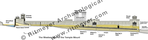
The Western Wall, which had four gates, was placed some 82 feet (25 m) outside the square platform with its southwest corner built on the opposite side of the Tyropoeon Valley.

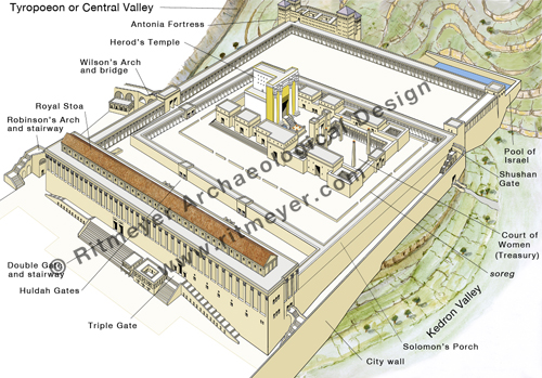
The Western Wall of the Temple Mount is 1590 feet (485 m) long. The Antonia Fortress is on the left. The four gates in the Western Wall are, from left to right, Warren’s Gate, Wilson’s Arch and bridge, Barclay’s Gate and Robinson’s Arch and stairway. This drawing also shows the lay of the bedrock below the Herodian street.

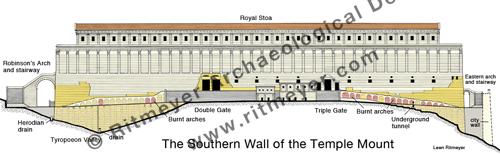
The Southern Wall featured two gates, the Double Gate and the Triple Gate, often erroneously referred to as the Huldah Gates.

The Southern Wall of the Temple Mount is 912 feet (278 m) long. The extant remains of this wall are shown in yellow. A monumental stairway led up to the Double Gate, indicating that this was an important entry point for many worshippers. In between this stairway and that leading up to the Triple Gate is a ritual bathing complex and a public building.

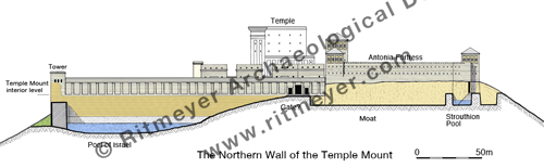
The most fortified feature in the Northern Wall was the massive Antonia Fortress (right in the drawing below), built to protect the Temple against attacks coming from the north and to guard the mount in times of strife. A large reservoir, the Pool of Israel (left) provided additional protection to the Temple Mount.

The Northern Wall of the Temple Mount is 1035 feet (315 m) long. The Pool of Israel, which was constructionally an integral part of the Temple Mount, can be seen on the left. The Antonia Fortress is on the right. A brief reference in Josephus points to the possible existence of a gate in the middle of this wall,.

Once the platform was completed, double colonnades, or porticoes, were built above the outer walls to provide shelter from the elements. A huge hall called the Royal Stoa, with four rows of columns, was erected on the southern end. The pre-existing eastern portico that stood on the square mount was left unchanged. As it belonged to a pre-Herodian period, it was called Solomon’s Porch. Near the centre of this platform a new gold-covered Temple was constructed that in turn was surrounded by many other buildings.

In 70 AD, this splendid structure that had taken 46 years to build (John 2.20) was destroyed by the Romans. The only vestiges of the compound to survive the destruction were the four retaining walls that supported the Temple platform; the best known today is the Western Wall.

This drawing is the 7th in this series that were made specially for the new Temple Mount guide book that is awaiting publication. For the previous drawings see: Mount MoriahJebusitesSolomonHezekiahNehemiah and the Hellenistic and Hasmonean periods.