Temple Mount Repairs Leave Eyesores

Hershel Shanks comments on the unsightly appearance of the repair of bulges in the Temple Mount walls that was done several years ago and the scaffolding that was left behind. The Waqf (Muslim authority over the Temple Mount) and the Israelis accuse each other of having caused these bulges, on one of which we reported in a previous post.

One of the first lessons I was taught during the MA course in the Conservation of Ancient Buildings at the Institute of Advanced Architectural Studies of the University of York, UK, was that one NEVER uses ordinary Portland cement in the repair of ancient buildings. It prevents ancient walls from “breathing” and eventually causes the collapse of these walls. The Waqf’s continued use of modern building materials in the repair of these bulges and other walls is the equivalent of putting a time-bomb in the walls of the Temple Mount.

Hershel asks himself the question about the remaining scaffolds: “They’ve been there now for several years. How much longer?” I can’t aswer that question, but I am sure that the unsightly repairs won’t be there for ever, for the ancient Temple Mount walls keep absorbing, not only the normal amount of rain water, but also the added amount of water that runs off the new paving that was laid at the southern end of the Temple Mount and that was also sealed with Portland cement. When ancient walls can’t breathe, they eventually collapse.

The Way to Golgotha in Jerusalem

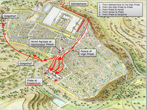
Feedback from customers who have purchased our new CD Volume 2: “Jerusalem in the time of Christ,” has been very positive, indicating that you have found it a really useful aid in understanding and teaching this topic. You can see a taster below of the final slide in the set. It shows the culmination of a series of five slides, each one building on the next and indicating a stage in The Way to Golgotha – Christ’s last journey in Jerusalem. Stages shown are:

From Gethsemane to the High Priest
From the High Priest to Pilate
From Pilate to Herod Antipas
From Herod Antipas back to Pilate
From Pilate to Golgotha

Five stages in the Way of the Cross

The traditional Via Dolorosa or Path of Sorrows was fixed by monks in Western Europe in the eighteenth century and a devotional procession along this route is still led by Franciscans every Friday. In fact, the streets upon which Jesus walked lie about 10 feet below the level of these thoroughfares. By contrast, The Way to Golgotha is firmly based on Scriptural and archaeological evidence, with the claims of the two alternative sites for the crucifixion clearly evaluated.

Recommended: The Sacred Bridge

We promised to review books that will stand the test of time. One of the books we treasure most (and which we would never dream of lending out, for fear of being left without it!) is The Sacred Bridge by Anson Rainey and Steven Notley. Reading it is like visiting a library with an erudite companion, who knows all the languages necessary to explore the culture in which you are interested or like walking in Bible lands with an omniscient voice guiding you: “This is the way, walk ye in it!”

The culmination of the life’s work of Anson Rainey, probably the world’s greatest authority on Semitic languages, together with Steven Notley, a notable New Testament scholar, this book contains learning more typical of nineteenth century scholarship, coupled with twenty first century presentation. Its prototype was the seminal Macmillan Bible Atlas, by Aharoni and Avi-Yonah, first brought out by Jerusalem’s Carta publishers in 1968 and which covered numerous aspects of the Biblical period.

The premise of this latest title is set forth in the blurb: “The Land of Canaan, the Land of Israel and early Roman Judea are treated as the southern part of the Levant, and as the focus in Ancient Near Eastern and Mediterranean history. The Levant is the land bridge between Asia and Africa, between Greco-Roman culture and the coasts of Arabia. As such it has seen the influx of peoples bringing new blood and initiatives to the life of the region. It has also suffered the conquerors’ heel as ancient empires sought to dominate this geographical hub of communications and commerce. The historical experience of the southern Levant, well documented in the Bible and in many inscriptions from Egypt, Mesopotamia, Syria and Anatolia, has become enshrined in Jewish/Christian tradition … It is therefore more than a land bridge between different cultures. It is a bridge of faith.”

The Sacred Bridge‘s main distinguishing feature is that it utilises the languages of the written sources to cast light on the Bible and its geography. Biblical texts are considered side by side with the other ancient Near Eastern sources, Egyptian, Akkadian, West Semitic and Greek. The use of colour coding makes a book with so many academic features more accessible. References are printed in red, original texts in light blue, with their translation in dark blue. It is very moving to read Lachish Letter No. 4, which bemoans the fact that the fire signals of Azekah, the only other fort remaining in Judah against Nebuchadnezzar’s campaign could no longer be seen from Lachish, in the original. There are very few books in the popular domain in which this is possible.

Produced by Israel’s best-known cartographic publishers, its maps, needless to say, are excellent and we have used them extensively in our work for a new digital Bible. On numerous occasions while mapping journeys, we were struck by the inevitability that Biblical characters chose to go by a certain route because of historic connections. An example of this would be the fact that both King David and Jesus crossed over the Brook Kidron after their betrayal. With the help of this magisterial volume, you too will be able to “pass through” Bible lands, as did the Hebrews (whose name literally means “passer through”), and absorb the lessons embedded in these singular places.

The Destruction of Jerusalem’s Temple and Rome

Archaeologists hope to find more pieces of the ancient Forma Urbis Severiana, a marble map that was attached to the wall of the Temple of Peace in Rome. A plan of the city during the time of the Roman Emperor Septimius Severus (193-211 AD) was incised on 150 marble slabs, arranged in eight rows and covering an area of 60 by 43 feet. It shows in astounding detail the layout of streets with housing insulae, temples, bath houses and commercial areas.

Several pieces of the world’s oldest and largest unsolved jigsaw puzzle, a 2,200-year-old map of Rome made of thousands of marble fragments, could be unearthed next year following construction work for a new metro line near Rome’s majestic forum area.
“This is a unique occasion to excavate the Forum of Peace, where the map once stood,” Rossella Rea, director of the Colosseum, told the Italian financial daily “Il Sole 24 Ore.”
Carved into marble slabs around  210 A.D., during the rule of the emperor Septimius Severus, the map was originally hung on a wall in the Templum Pacis (Temple of Peace), which stood in the middle of an enclosure called Forum of Peace.
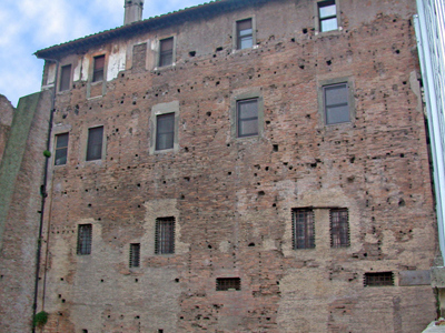
The wall still survives today in a building near the 6th-century Church of Santi Cosma e Damiano. Rows of holes where the map was attached using bronze clamps can still be seen.

Surviving wall of the Temple of Peace. Bronze clamps were fixed in the holes of the wall to keep the marble slabs in place

Reporter Rossella Lorenzi mentions the fascinating connection with the destruction of the Temple of Jerusalem in 70 AD:

The centerpiece of the Forum of Peace was indeed the temple. Built in 71-75 A.D by Vespasian, the Temple of Peace celebrated the brutal pacification of the Jews and the destruction of the Temple at Jerusalem in 70 A.D.
Tons of gold, silver trumpets and gold candelabra were plundered from the Jerusalem temple and paraded through Rome’ streets in triumph.
The moment was captured in a frieze carved into the Arch of Vespasian’s son, Titus, which clearly shows the menorah, the seven-branched temple candelabra that was the symbol of ancient Judaism, being exposed through the streets.
Between 75 A.D. and the early 5th century, the treasure, which helped finance the building of the Colosseum, was put on public display right in the Temple of Peace.
Although it is unlikely that fragments from the treasure are unearthed, the archaeologists hope to bring to light other precious remains from the Forum of Peace.

Marble pieces from the Forma Urbis Severiana - the Plan of Rome in about 210 AD

HT: Joe Lauer

Elevator for the disabled near the Temple Mount

According to this report, the Company for the Reconstruction and Development of the Jewish Quarter plans to build an elevator inside an underground tunnel leading from the Jewish Quarter to the Western Wall Plaza.

The report tries to draw a historical parallel with the Temple Mount that stood in Jerusalem 2,000 years ago:

Two thousand years ago, stone bridges connected the Jewish Quarter directly to the Temple Mount, saving the high priests the long trek down and back up.

There was actually only one bridge, namely the Bridge of the Priests that was constructed over Wilson’s Arch between the Temple Mount and the Upper City – now the Jewish Quarter. The other arch, Robinson’s Arch, carried a stairway down to the street along the Western wall:

Despite the fact that the exit of the tunnel will be located about 1,000 feet to the west of the Temple Mount, according to this report the Arabs are, predictably, against it.

The purpose of the underground elevator “would greatly improve access for visitors in wheelchairs or those with other disabilities, who now have to contend with several flights of stairs”, but the Arabs claim “that the area in front of the wall could be used as a base from which to attack the mosque compound.” Even helping disabled people in Jerusalem is looked upon as suspicious by the Arabs.

HT: Joe lauer

Lost in words – Recommendations from our library

Libraries have transformed our lives. Living in Jerusalem, as we did for many years, we had access to some of the world’s greatest libraries. The Hebrew University had the largest collection of works on Jewish culture (many donated by supporters of the fledgling State of Israel). Sadly, some of these precious volumes were vandalised by students, with many of the books’ spines broken due to photocopying or even missing pages! Our professor, Benjamin Mazar, also had a prodigious book collection at his home in Rehavia, which he shared very generously with us. It was the library of the École biblique et archéologique française, however, that blew our bibliophile’s socks off. Here, such solicitous care was taken of the library’s 140,000 volumes, that a “fantôme”, or mock volume had to replace every book that was removed, until said book was returned to safety.
The more we read, the more the city of Jerusalem and the Land of Israel stepped out of the shadows and into our comprehension. We were cool university students no longer, when we perhaps did not appreciate the richness of the Library of the Academy in Arnhem or Dublin’s splendidly domed National Library. We hungered to understand the lessons that the past of our adopted country could teach us.

Reading Jerusalem Revealed, when it came out in 1975, was an epiphany, making sense of the results of the explosion of excavations that had become possible after the 6-Day War. We carried single volumes of Josephus around in our pockets, seeking his contemporary witness to the ancient city we were trying to build up in our minds. We scrutinised the tractates of the Mishnah, some of which were written by rabbis who had observed the ritual of the Temple prior to its destruction in 70 A.D. Each book stood out like a milestone and we felt that we were becoming the sum of the books we had read. We must remember that because of the unprecedented opportunities in archaeology at that time, there was a flowering of works reporting on the dramatic new discoveries. Kathleen remembers comparing the books that were appearing then, with the single book, Kenyon’s Archaeology in the Holy Land, that was recommended for her course on this subject in University College Dublin in the early 70’s!

Now we live in Cardiff, Wales, far from the enticements of the Bodleian and British Libraries. However, due to our drawings being printed in numerous publications and the requests for book reviews we receive, we have managed to amass our own extensive private library. We can truly say that our books transport us every day to the Land, allowing us to live a life unfettered by sea or border crossings. In our book-lined space, we can explore Jerusalem’s Gihon Spring, walk around the destroyed city walls with Nehemiah or bring in our boat to harbour in first century Capernaum – all without leaving our chair.

Despite the dominance of Google, we are often asked to recommend books to our readers. For that reason, we hope to regularly post reviews of publications (and occasionally movies or software) we consider useful, defining and illuminating. Look under the Recommended menu for reviews of works that will stand the test of time!

Islamic Destruction of the Temple Mount report

By Anshel Pfeffer, August 12, 2010


Tons of rubble was removed from under Temple Mount by the Muslim authority that oversees the site

An investigation into the failure of law enforcement agencies to prevent what is alleged to have been an attempt to wipe out Jewish history on Temple Mount 11 years ago looks set to cause widespread controversy.

The publication of the report into the removal, by night, of 6,000 cubic metres of mud from beneath the Al Aqsa Mosque by the Muslim Wakf authority that oversees the management of the mosque compound, has been suppressed for months by the government.

The dirt was dug out to make way for a new underground mosque, but Israeli archaeologists and politicians claim that another motive of the Wakf and the Islamic Movement – which financed the work – was to remove evidence of Jewish history from the site where the two temples of Jerusalem stood.

The excavation and building was carried out without any official permit from the planning authorities. Belated intervention by the Justice Ministry, spurred on by a rare petition signed by politicians, writers and archaeologists from the right and the left, brought the digging to an end, but it was too late.

Thousands of volunteers have been sifting ever since through the hundreds of tons of dirt, dumped in a valley east of Jerusalem, unearthing rare remnants of the Temple Mounts from all ancient periods of Jerusalem, going back to the Bronze Age. Among them were fragments and coins from the First and Second Temples, and relics of the Persian, Babylonia, Maccabean, Herodean, Roman, early Christian and Byzantine eras. The work is of questionable historic value as the rules of archaeology mandate that findings should be recorded in their original location, but is still ongoing.

Meanwhile, for the last three years, the Comptroller’s Office has been conducting an investigation into the way the Israeli government, the police and Jerusalem City Hall have relinquished control of the sacred site.

“The conclusions are clear,” says one source who has seen the report, “Israeli law ends at the gates to the Temple Mount.”

The reason for this is the same motive that has caused the government to try and suppress the report for the past few months, previous attempts to enforce Israeli sovereignty over the Temple Mount have provoked widespread Palestinian violence, as did the visit of the opposition leader, Ariel Sharon, in September 2000, which sparked the second intifada.

“On the one hand, no government wants to be seen as impotent,” said a security official in Jerusalem, “but they prefer keeping the status quo on the Temple Mount to another intifada with all that entails. Even when the report finally gets out, the government will do everything in its power to play it down.”

HT: Joe Lauer

Jerusalem in the time of Christ – New CD-Rom

Conveniently timed to coincide with the beginning of the academic year, our new CD-Rom is now available. We promised to bring out our immensely popular slide set, “Jerusalem in 30 A.D.”, in digital format and we hope you will be pleased with the result. Re-named “Jerusalem in the time of Christ”, this CD has a bumper 85 pictures, as compared to the original slide set’s 36.

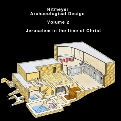
Volume 2: Jerusalem in the time of Christ

The advances of the digital age allowed us to focus much more on the city that Jesus knew. New drawings have been specially made in order to assist the viewer in opening a door to this historical world. One of our favourite new drawings shows a reconstruction of a small aedicule depicting the snake god of healing, Asclepius, found at the Pools of Bethesda. This find movingly reminds us how appropriate it was for Jesus to heal the paralytic man at this pagan healing centre, decisively refuting the claims of the serpent god.

The classic reconstruction drawing “Jerusalem in 30 A.D.,” which originally took 3 weeks to make, has been used as a base on which to create a ground-breaking series of slides showing The Way to Golgotha. Each of these five slides shows a stage in Christ’s last journey, beginning at Gethsemane and culminating at either of the two sites identified as the place of the empty tomb.

Other locations depicted include the Pool of Siloam (including the latest discoveries), the Essenes Gate, the Praetorium and Solomon’s Porch on the Temple Mount. Each picture is accompanied by a fully descriptive caption, with Bible references, allowing you to resurrect the place and period and to see for yourself how firmly the Gospels are rooted in the actuality of Jerusalem.

For those of you who may be wondering, the new cover illustration shows a reconstruction of the sumptuous mansion identified as having belonged to the High Priest Annas and the likely site of Peter’s betrayal of his master.

Virtual Model of the Temple Mount in the Time of Jesus

From Justin Taylor’s blog:

For several years UCLA’s Urban Simulation Team has been working on a virtual reconstruction of Jerusalem and the Temple Mount prior to the destruction of A.D. 70. In collaboration with the Israel Antiquities Authority they have put together a display at the Ethan and Marla Davidson Exhibition and Virtual Reconstruction Center in Jerusalem.

Below is a video clip—the model was created by Dr. Lisa M. Synder—showing what the Temple Mount and Herod’s Temple would have looked like in the time of Jesus.

This video is not new, but always worth watching. The UCLA’s Urban Simulation Team are the ones who developed the Temple Mount animation at the Davidson’s Visitors Centre at the entrance to the Temple Mount Excavations in Jerusalem.

I got to know Justin Taylor when he was Project Director and Managing Editor of the ESV Study Bible.

This site allows you to download the trailer of another Temple video, which I worked on a few years ago. These videos are really useful if you want to imagine what the Temple looked like in the time of Jesus.

Here is the video itself:

New RAD Web Design

Thanks to our web designer we have been able to revamp our website and we hope you like the new design. A reconstruction drawing of the Eastern Wall of the Herodian Temple Mount with the Temple appears in the header, which we plan to eventually rotate with other designs.

The upgrade is not meant to be a pretty face only, but we hope to put more information on the site. We have started with our new Showcase, giving you an idea of the projects we have been involved in over the last few years. Please have a look …

We also plan to list reviews of books, movies and software which we have found particularly helpful for students of Biblical Archaeology.

We are even more excited about putting up an archive with photographs of archaeological sites and reconstruction models and also, of course, reconstruction drawings. Thumbnails of the illustrations will be available for all to see, with an option to buy low resolution pictures for Powerpoint presentations and high resolution ones for publishers.

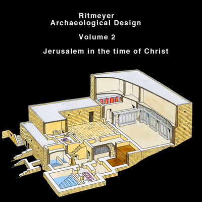
Many of you have asked why Vols. 2 and 3 are missing from the list of available CD-ROMs. Well, you won’t have to wonder much longer, as we are about to release these volumes. Volume 2 is called Jerusalem in the time of Christ:

Cover for Volume 2: Jerusalem in the time of Christ

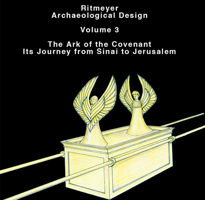
Volume 3 is called The Ark of the Covenant – Its Journey from Sinai to Jerusalem, and we will let you know as soon as they are available.

Cover for Volume 3: The Ark of the Covenant - Its Journey from Sinai to Jerusalem

Many years ago, we produced slide sets on these subjects and now the time has come to go digital. Whereas the two slide sets contained only 36 slides, the new CD-ROMs will have many more, with new digital or digitally enhanced pictures.

Another presentation on the Seven Churches of Revelation is also in the works.