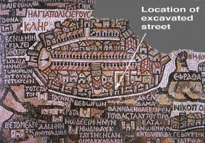
A few days ago an ancient street was found in Jerusalem in an archaeological excavation inside the Jaffa Gate, next to the remains of the Hippicus Tower. This exciting find has been reported by many commentators. This CBN news item, however, shows an interesting video of the excavated street. The excavators have pointed out that this street was shown on the Madaba map:
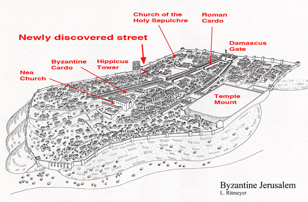
This map also guided the late Prof. Nahman Avigad to find the Byzantine Cardo in the Jewish Quarter of the Old City of Jerusalem. Using this map as a basis and taking all the Byzantine remains found in Jerusalem into consideration, I was able to make a reconstruction drawing of the city during that time. This then is a view of Jerusalem during the Byzantine period, showing the street complex and the many the Christian churches that were built at that time. Many Christians lived in Jerusalem, which was also visited throughout the year by Christian pilgrims.


Leen,
Thanks for the drawing. By Byzantine, what ‘year’ would you say this is a reasonable view of? Have you ever done a drawing of the city when called Aelia Capitolina and showing the pagan temple where the Holy Sepulcher is standing in this drawing? This timeframe remains rather cryptic with the obvious scholarly focus, writings aimed at 2nd Temple period and jumping to this period. I am interested is visual resources for the in-between time. Another point, the Temple Mount plaza area here is shown as an open field. What was its chronological status from say, 73 CE through 300 CE? Can you shed some light here? I LOVE YOUR SITE and YOUR WORK … thanks for sharing so much. I have two of your books. Thanks again. ~dmw
Daniel,
The Byzantine period began in about 324 A.D when Constantine the Great made Christianity the state religion. My drawing shows the Nea Church, which was built by Justinian in the middle of the 6th century A.D. I do have a similar drawing of Aelia Capitolina. There may or there may not have been a small Roman temple on the Temple Mount during the Roman period (70-324 A.D.), but the site was thoroughly neglected in the Byzantine period, apart from perhaps one or two small buildings at the southern end of the mount.
Is that supposed to be a cutaway at the southern end of the Temple Mount or did the wall really fall in that period?
The drawing shows the exact extent of the Roman destruction of the southern Temple Mount wall.
Thanks for clearing that up!
have you found the secret tunnel that runs from the (double wall) of the temple to the kidron east of the temple?
Elizabeth, I’m not sure which tunnel you have in mind.