In his Weekend Roundup, Todd Bolen mentioned that “The Israel National Library website has an extensive collection of maps of Palestine, dating from 1462 to 1927.”
Hundreds of maps of Jerusalem and the Holy Land have been digitized and put on the website. This is a treasure trove for map lovers. The website has a fascinating introduction to the Story of the Maps. You can search for maps by date or by the person who made them. Many maps have been made by fellow Dutchmen, which made me feel at home.
Being in the process of building our own Image Library, which involves the scanning and digital enhancing of the many drawings I have made over the last decades, we can fully appreciate what a laborious work it must have been to get all these maps digitized.

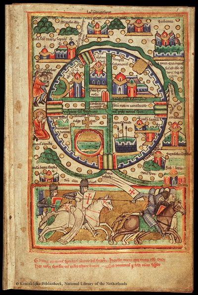
My attention was naturally drawn to the special section on Jerusalem. The oldest digitized map dates from ca. 1200 and is well-known, having been reprinted frequently. The original map is part of a Latin Psalter which is kept in the Koninklijke Bibliotheek (National Library of the Netherlands) in The Hague.

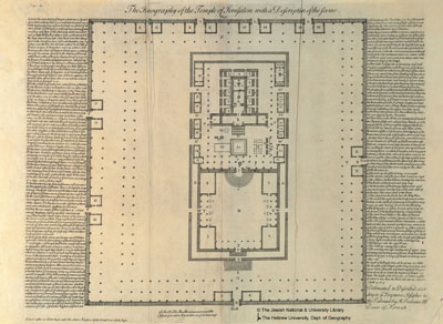
A Temple plan, entitled “The Ichnography (ground plan) of the Temple of Jerusalem with a description of the same. Delineated & Described according to the Scriptures, Josephus & the Talmud by H. Prideaux DD. Dean of Norwich” shows that he has struggled to harmonize the Temple descriptions in Josephus and the Mishnah. The lengthy description makes for interesting reading.
Looking at these old maps, we can be thankful for the many archaeological excavations that have taken place in Jerusalem and are still on-going, so that we now have a much clearer picture of Jerusalem and the Holy Land.

I would like to know the name if this lame man whi was sitting at the beautiful gate
So would I!