Roman Jerusalem

While studying Conservation at the Institute of Advanced Architectural Studies at the University of York, archaeologists of the York Archaeological Trust showed us graphs indicating that the number of visitors coming to York during the month of February was always the lowest. That is why they organize the Jorvik Viking Festival every year, which includes the burning of a Viking boat on the river (incidentally, the website has a page on Barley Hall, the restoration of which I was fortunate to have been involved with).

This general trend is well-known in commerce and tourism, hence the protracted sales and low prices to attract customers during February. That may have been the reason why Haaretz put up an article on Roman Jerusalem, then called Aelia Capitolina, which is well written and interesting, but contains nothing new.

The fact that the straight streets, such as Chabad and Hagai, David Streets and the Via Dolorosa, date back to the Roman period has been known for a long time. Both the Cardo Maximus and the Lower Cardo began at the Damascus Gate in the north of the city, as shown on the Madaba Map.

The Damascus Gate is located in the centre of the northern wall of the Old City of Jerusalem. The gate was built in the 2nd century AD during the reign of the Roman Emperor Hadrian as a monumental entrance to the city of Jerusalem, which he had renamed Aelia Capitiolina. This gate features on the Madaba Map, which shows an open square with a column inside the gate. © Leen Ritmeyer

The very interesting excavation to the west of the Western Wall Plaza, where a good stretch of the Lower Cardo was found, has been well documented previously and the street was known long ago from the Madaba Map. The discovery of a Roman Bath house has also been reported earlier, as was a Roman building in the Givati parking lot.

After the Roman destruction of 70 A.D., the 10th Legion set up an encampment south of the Hippicus Tower on the Western Hill of Jerusalem. After nationalistic uprisings, Hadrian flattened the city and in 135 A.D. built a new one on its ruins and called it Aelia Capitolina. The major buildings are the Damacus Gate in the north, a Temple of Aphrodite, two forums (market places) and there may have been a Temple of Jupiter on the Temple Mount. © Leen Ritmeyer

Experts agree the city was planned extraordinarily well, based as it was on designs of other cities in the empire and according to orders that came directly from the emperor.

To be sure, some new evidence has come to light during the last decade, but nothing revolutionary or earthshaking that was not known many years ago.


HT: Joe Lauer

The Burnt House in the Old City of Jerusalem

Avigad would be pleased! Yesterday we received Vols. IV and V of the final reports of the Jewish Quarter Excavations in the Old City of Jerusalem, Conducted by Nahman Avigad 1969-1982. The first four volumes were edited by Hillel Geva and the fifth by Oren Gutfield. More volumes are in preparation.

This web page contains descriptions and downloadable PDF flyers, with pictures of the book covers, contents and order forms.

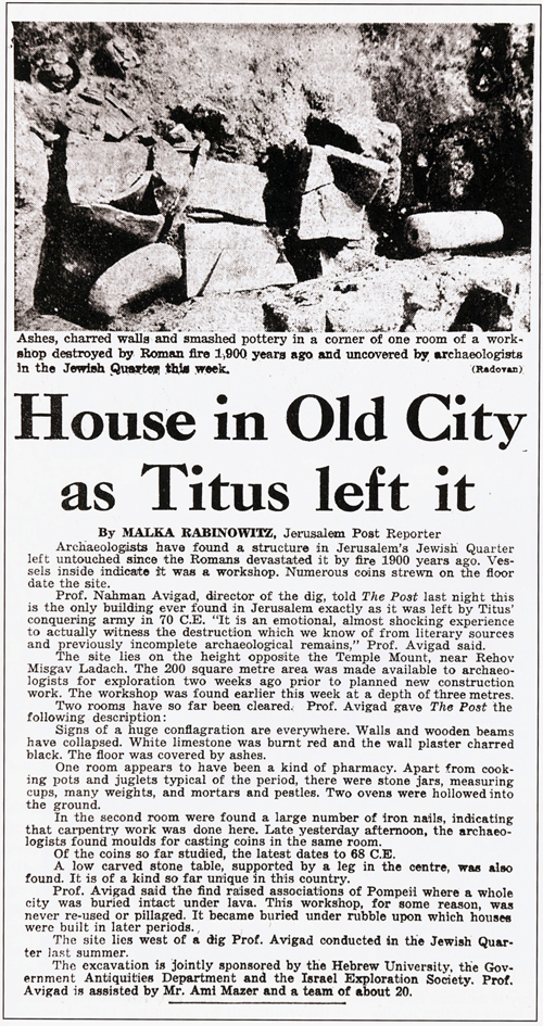
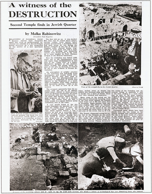
It was a mammoth task to prepare these volumes and Hillel and Oren are to be commended for their dedication and hard work to publish the results of these unique excavations. I can’t resist sharing these newspaper reports of when the Burnt House was first discovered and that were reproduced in Volume IV.

The Jerusalem Post, 16 Jan. 1970


Jerusalem Post, 23 January 1970

I remember Avigad telling me that during the excavation of the Burnt House, people were standing 4-deep around the area  being dug, especially after the finding of a girl’s skeletal arm, the nation of Israel was so electrified.

After working on the Temple Mount Excavations, I began working on the Jewish Quarter Excavations, beginning in 1978. It was a very memorable privilege to have been able to draw up most of the plans for the Burnt House and other areas which were excavated in the quarter, which had been severely damaged by the Jordanians. Working for Avigad wasn’t restricted to my architectural contributions. When the Burnt House was eventually opened to the public, I was honored, to be the only one, with Kathleen, to be entrusted with the care of cleaning the glass display cases of the precious finds from the site. On a number of evenings we had to get a baby sitter for our children so we could drive over the cobble stones of the Jewish Quarter and take our vacuum cleaner and dusters into the eerily silent Burnt House.

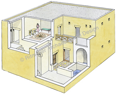
Eventually, I made this reconstruction drawing of Burnt House:

Reconstruction drawing of the Burnt House. Leen Ritmeyer

Fiscal bulla found in Jerusalem

A few days ago, the Temple Mount Sifting Project published an article about a fiscal bulla (a lump of clay that bears the imprint of an inscribed seal) that was found in an excavation on the eastern slope of Mount Moriah:

The bulla carries an Ancient Hebrew inscription: “[g]b’n/lmlk“, i.e. “Gibeon, for the King”. The bulla originates from the eastern slope of the Temple Mount, descending into the Kidron Valley. The bulla belongs to a group of bullae which were called by N. Avigad “Fiscal Bullae”. Presently we know more than 50 bullae of this type. They comprise two groups, one with names of cities in the kingdom of Judah, and the other with names of royal officials.

The Gibeon bulla, showing the inscription on the left and the back of the bulla on the right. Photo: Zev Radovan
The inscription of the bulla, reconstruction by Gabriel Barkay.

These ‘lmlk’ (for the king) bullae sealed tax commodities sent to the King of Judah and date from the time of King Hezekiah. About 50 of these fiscal bullae are known, but this is the first one that came from an archaeological rescue excavation. Gabriel Barkay has published an extensive article (in Hebrew) in which he discusses the entire phenomenon of the fiscal bullae.

The bullae include names of 19 different cities of Judah, and dates of the reign of one of the Judean kings, usually in hieratic numerals, as well as the particle lmlk, “for the king”. The components of the inscriptions are discussed, as well as the geographical history of the bullae, and its comparison to the list of Judean cities in Joshua 15: 20-63. The fiscal bullae represent a taxation system from the different Judean cities, based on yearly taxes, which probably replaced the previous one, reflected in the royal Judean jars and their seal impressions, from the time of King Hezekiah.

Not all of the cities, however, are mentioned in Joshua 15. Two cities belonged to Simeon, Eltolad and Bethul, and Gath was a Philistine city during most of the Biblical period. Here is the list of the 19 cities and where they are mentioned first:

  1. Eltolad (Josh. 15.30, 19.4; Tolad 1 Chron. 4.29)
  2. Lachish (Josh. 15.39)
  3. Nezib (Josh. 15.43)
  4. Arab (Josh. 15:52)
  5. Keilah (Josh. 15.44)
  6. Gebim (Isa. 10.31)
  7. Maon (Josh. 15.55)
  8. Jagur (Josh. 15.21)
  9. Gath (Josh. 11.22)
  10. Bethul (Josh. 19.4, Chesil Josh. 15.30, Bethuel 1 Chron. 4.30)
  11. Aphekah (Josh. 15.53)
  12. Gibeah (Josh. 15.57)
  13. Adullam (Josh. 15.35)
  14. Zaanannaim (Zenan Josh. 15.37)
  15. Socoh (Josh. 15.35)
  16. Gibeon (Josh. 9.3)
  17. Zarah (Hazor Josh. 15.25)
  18. Adoraim (2 Chron. 11.9)
  19. Ziph (Josh. 15.55) – Judah

These originally were all Canaanite cities that were conquered by Joshua and were still part of the Kingdom of Judah during the reign of King Hezekiah.

The city of Gibeon, viewed from the south. Photo: Leen Ritmeyer

Gibeon did belong to a group of four Canaanite cities that made a covenant with Joshua by disguising themselves. After having been found out by Joshua, he made them hewers of wood and drawers of water for the house of God (Joshua 9).

Mysterious carvings found in City of David excavations

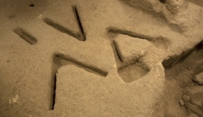
In today’s Haaretz it is reported that mysterious 2,800 year old V-shaped carvings were found in the City of David.

Mysterious stone carvings made thousands of years ago and recently uncovered in an excavation underneath Jerusalem have archaeologists stumped.

Israeli diggers who uncovered a complex of rooms carved into the bedrock in the oldest section of the city recently found the markings: Three "V'' shapes cut next to each other into the limestone floor of one of the rooms, about 2 inches (5 centimeters) deep and 50 centimeters long. Photo: AP

The archaeologists in charge of the dig know so little that they have been unable even to posit a theory about their nature, said Eli Shukron, one of the two directors of the dig.

“The markings are very strange, and very intriguing. I’ve never seen anything like them,” Shukron said.

It is possible, the dig’s archaeologists say, that when the markings were made at least 2,800 years ago the shapes might have accommodated some kind of wooden structure that stood inside them, or they might have served some other purpose on their own. They might have had a ritual function or one that was entirely mundane. Archaeologists faced by a curious artifact can usually at least venture a guess about its nature, but in this case no one, including outside experts consulted by Shukron and the dig’s co-director, archaeologists with decades of experience between them, has any idea.

Dating the Western Wall of the Temple Mount in Jerusalem

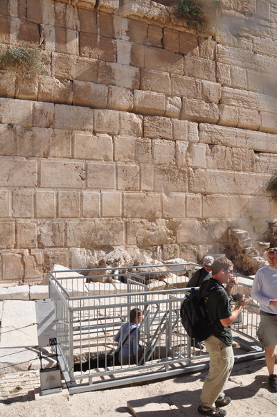
The announcement of the new theory on when the Western Wall was built (see here and here) was not as dramatic as expected. The discovery of coins, the latest of which were struck by the Roman procurator Valeruis Gratus in 17-18 AD, in a mikveh that went out of use when the Western Wall was built over it, suggests that the building of the Temple Mount walls took decades. This is the full report released by the Israel Antiquities Authority.

A picture of the two coins that were found in the mikveh. The coins date from the time of the Roman procurator Valeruis Gratus (17-18 AD). Photo: Vladimir Neichin/IAA
This picture shows that the Western Wall was built over the remains of a mikveh. Photo by Vladimir Neichin/IAA
Photo of the excavation of the mikveh by Vladimir Neichin/IAA

This late date is not surprising, as at the beginning of Jesus’ ministry, usually dated to 30 AD, it was said that this Temple complex had been in building already for 46 years (John 2.20).

At the northern end of the Western Wall is a piece of bedrock that wasn’t even removed before the Temple was destroyed by the Romans in 70 AD.

A huge block of bedrock that was never quarried is visible at the end of the Western Tunnel. The Western wall is visible on the right and on the left is the street that was paved around the protruding piece of rock. Photo: © Leen Ritmeyer

This doesn’t mean to say that the Western wall is not Herodian. The whole building concept was designed by Herod the Great and completed after his death.

The Western Wall of the Temple Mount in Jerusalem

The Spokesperson of the Israel Antiquities Authority “circulated an invitation to journalists to attend a press conference tomorrow (Wednesday, November 23, 2011) at which “A find will be presented that challenges the conventional viewpoint in archaeology regarding the construction of the Western Wall of the Temple Mount.”

Although it sounds mysterious, Ronny Reich, whom I met very recently in Jerusalem, said that he has new information about the construction date of Robinson’s Arch. It will be interesting to see what he has to say.

HT: Joe Lauer

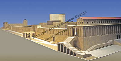
A view of the southwest corner of Herod's Temple Mount. In the foreground is Robinson's Arch with its monumental stairway that led up from the main street in the Tyropoeon Valley and entered the Royal Stoa through a gateway. On the left of Robinson's Arch is Barclay's Gate with Wilson's Arch at far left. The Temple towered high above the Temple Mount. © Leen Ritmeyer

Walking through the Herodian sewer in Jerusalem

In the previous post we mentioned the opening of the Herodian sewer in Jerusalem. One can now walk underground from the Siloam Pool to the Temple Mount. Last week, we were one of the first groups to walk through this drain/sewer, that collected the rain water that fell on the street and drained the sewage from the adjacent buildings. Here is a photographic record of the tour:

From the Siloam Pool one first walks on the Herodian street itself, while later on one walks through the sewer that was built below the street. Photo: © Leen Ritmeyer
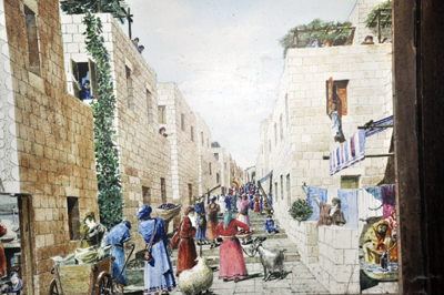
At the entrance to the underground sewer is a reconstruction painting that shows what the Herodian street would have looked like. The drain ran below this street.
This picture shows the excellent preservation of the drain. It also brings to mind that here many Jewish people, who were trying to flee the city in 70 AD, were killed by the Roman soldiers. Photo: © Leen Ritmeyer
The sewer passes by the southwest corner of the Temple Mount. Here we see the lowest courses that were built on the bedrock. The bosses of the ashlars were left unfinished as they were never intended to be seen above ground. Photo: © Leen Ritmeyer
Just below Robinson's Arch a fallen arch stone, that must have crashed down during the construction of Robinson's Arch, is wedged in between the two side walls of the drain. The clearing of the sewer is still continuing. Photo: © Leen Ritmeyer
This part of the drain was already discovered by Warren and his team in the 1860's. The fallen arch stone in this painting is the same one you see in the picture above.
This painting shows Sergeant Birtles, who worked with Warren in the 1860's, going down from below Robinson's Arch into the drain in between the fallen Herodian stones. The modern exit follows the same route.
Warren's drawing showing the relationship between Robinson's Arch and the drain below.
At the end of the tour one exits onto the Herodian street below Robinson's Arch. Photo: © Leen Ritmeyer


Want to walk through a sewer in Jerusalem?

Don’t fear, the sewer is dry! One can now walk underground through the full length of the 2,000 year old Herodian drainage channel that ran below the street from the Siloam Pool to Robinson’s Arch near the Temple Mount. The route of the street is indicated on the drawing below:

The Jerusalem shown in this reconstruction drawing shows the culmination of King Herod the Great's extravagant plan for the city. He found it a city, struggling under the Hasmonean dynasty to regain her original boundaries of the First Temple period - he left it a sophisticated metropolis. © Leen Ritmeyer

Tom Powers has an excellent description using recent photographs and my map of this drainage system that I used in a previous blog post to explain its construction during the Hasmonean period and the Herodian bypass that was made after the construction of the southwest corner of the Herodian Temple Mount cut the earlier drain.

In an earlier post I wrote:

It will be exciting to walk again through this tunnel, but while doing so, one should also remember that in 70 AD many Jerusalemites tried to escape through this same tunnel, but were cruelly killed by the Romans when they were discovered.

Lectures at the Palestine Exploration Fund, London

If you’re in London during the next few months, you may find the following lectures interesting:

06 October 2011
The Petra Effect: Archaeology and Psychical Research at George Horsfield and Agnes Conway’s Excavations
10 November 2011
War, Politics and Trade in the Roman Red Sea
08 December 2011
The Society of Biblical Archaeology 1870-1919

Have Archaeologists Discovered High Priest’s Bell?

Archaeologists have discovered a rare gold bell during an excavation in the City of David National Park in Jerusalem.
by Elad Benari

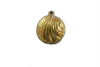
Archaeologists have discovered a rare gold bell with a small loop at its end. The finding was made during an archaeological excavation in the City of David National Park (near the walls of the Old City of Jerusalem) by the Israel Antiquities Authority in cooperation with the Israel Nature and Parks Authority and the Ir David Foundation.

Rare ancient bell. © IsraelNationalNews

The directors of the excavation on behalf of the Antiquities Authority, archaeologists Eli Shukron and Professor Ronny Reich of Haifa University, said after the finding, “The bell looked as if it was sewn on the garment worn by a man of high authority in Jerusalem at the end of the Second Temple period.

“The bell was exposed in the city’s main drainage channel of that period, between the layers of dirt that had been piled on the floor of the channel,” they continued. “This drainage channel was built and hewn west to the Western Wall of the Temple Mount and drained the rainfall in the different parts of the city, through the City of David and the Shiloah Pool to the Kidron valley.”

The excavation area, above the drain, is located in the main street of Jerusalem which rose from the Shiloah Pool in the City of David. In this street an interchange was built through which people entered the Temple Mount. The remains of this interchange are what is known today as Robinson’s Arch. Archaeologists believe that the eminent man walked the streets of Jerusalem in the area of Robinson’s Arch and lost the golden bell which fell off his outfit into the drain beneath the street.

Jewish sources say that the high priests who served in the Holy Temple in Jerusalem used to hang golden bells on the edges of their coats. The book of Exodus (Shemot), for example, contains a description of the coat of Aaron the high priest in which it is said that coat contains, “bells of gold.”

While it is unknown if the bell belonged to one of the high priests, archaeologists have not ruled out the possibility.

The holy garments of the High Priest are described in Exodus 28 and 39. A golden plate with an inscription "Holy to Yahweh" was fixed to a white head covering. A colourful vest, called the ephod, had the breastplate of judgment with 12 precious stones attached to it. On the shoulders were two onyx stones with the names of the 12 tribes of Israel engraved on them. Under the ephod was a robe of blue and a long white undergarment. Attached to the hem of the blue robe were bells and pomegranates. © Leen Ritmeyer