Jerusalem and Rome

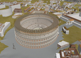
Google Earth have brought out an exciting “Fly into Rome as it looked in 320 A.D.” animation. You can see it here. Below is a snapshot digital reconstruction of the Colosseum:

If you don’t have Google Earth, you can download it for free here.

With thanks to Justin Taylor, who alerted me to this.

King Solomon’s Copper Mines

Excavations in Jordan have revealed copper mines that were in use during the 10th Century B.C., i.e. the time of King David and Solomon. The site is called Khirbat en-Nahas, which means ‘the ruins of copper’. The massive smelting plant was probably operated by King Solomon, who may have derived part of his wealth from this site, just a King Herod the Great amassed huge wealth from the mining of copper in Cyprus. The site has also revealed some Egyptian artifacts, which may be related to the invasion of the Egyptian Pharaoh Sheshonq (Shishak of the Bible), soon after Solomon’s death. You can watch an interesting video here about these excavations, which were led by Thomas Levy of the University of California in San Diego.


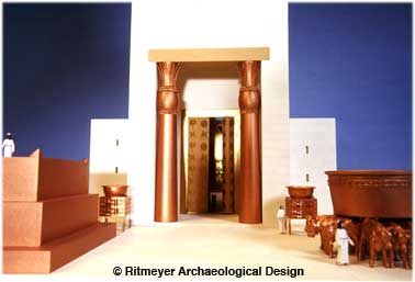
Huge amounts of bronze, an alloy of copper and tin, were used in Solomon’s Temple for the two pillars, Yachin and Boaz, the Altar, the Great Sea and other installations, as shown in this model of Solomon’s Temple.

Some scholars have cast doubt on the existence of the fabled King Solomon, because of the few remains of the 10th Century B.C. that have been found, especially in Jerusalem. However, when King Hezekiah created a new artificial platform around the renovated Temple, the remains of Solomon’s Royal Complex, such as his Palace and the House of the Forest of Lebanon, may have been dismantled and therefore will never be found. It does not mean, of course, that they never existed.

www.godtube.com

Although I don’t like the title of this website (God doesn’t need a tube), it has an interesting video discussion between J R Church and Gary Stealman about my book The Quest. They didn’t get all the facts right, but they gave an enthusiastic review of my book The Quest. Worth watching.
If you are not a member of www.godtube.com, go to the website and select ‘videos’ from the menubar. Copy in this code: 20ed975e82b7fd877693 and the video should be ready for watching.

Temple Mount ban

Here you can read one of the latest articles on “Jews in the Temple Area: A ‘Mount’-ing Controversy”. Three rabbis, Rabbi Yoseph, Rabbi Elyashiv and Kanievsky, demand a complete ban on Jews entering any part of the Temple Mount on the grounds that the ritual purity of the area might be violated.

On the other hand, there are a growing number of rabbis, such as Rabbi Moshe Tendler, Rabbi Yehuda Kreuzer and the rabbis of the Temple Institute, who believe that Jews should be allowed to enter onto the Temple Mount, and in an interview with IsraelNationalNews, Rabbi Kreutzer cited a well-known rabbinical source: “In short, the Radbaz [a leading halachic authority from the 1500s] ruled that the Dome of the Rock is the Foundation Stone in the Holy of Holies…. He wrote that without a doubt this is the identity of the place. He wrote in a definite way the definite identity of the place,” Kreuzner reiterated. “If so, it’s possible to do the measurements.”

The “measurements” have been done already, for there is so much archaeological evidence to show that the Rock inside the Dome of the Rock is the Foundation Stone, that is indeed possible to set out the precise location of the Temple and its courts. For the last 30 years, I have used the information of Middot, Josephus and archaeology to analyze the Temple Mount.

The pre-Herodian Temple Mount was a square platform of 500 cubits, inside of which was the soreg, a partition screen to keep out Gentiles and Jews who were disqualified from entering the inner courts. Further inside was the Court of the Women and the Azarah, the court around the temple itself, which was accessible to priests only.

The location of the soreg in the southern court depends on the location of two Temple Mount mikvaot, Cisterns 6 and 36 according to Warren’s enumeration, and the soreg should be located just to the north of them. Mikvaot were used for ritual bathing, which, of course, needs to be done before entering the holy area. Even if the rabbis would stay outside of the soreg, there is ample space on the Temple Mount for them to walk on.

The Court of the Women was located east of the raised Muslim platform and the Azarah was located on this platform. By staying off the platform, rabbis could never defile the Holy of Holies, which was located inside the Dome of the Rock. Even walking on the raised platform, there is no danger of trespassing on the Holy of Holies.

If the fear of the rabbis is to tread of the area of the Holy of Holies alone, then they should stay outside of the Dome of the Rock and the rest of the Temple Mount should be accessible to them.

On the detailed plan below, the pre-Herodian Temple Mount is indicated in yellow. and the soreg in the southern court is just north of the two mikvaot. The raised Muslim platform is grey and the Herodian Temple Complex is in red.

Jerusalem reconstruction drawings

In the middle of this promotional movie for the new ESV Study Bible (available from 15 October, 2008), you can see my reconstructions of Jerusalem and the Temple in the various periods and which have been painted beautifully by Maltings Partnership, U.K.

First you see the City of David, followed by Solomon’s Jerusalem and Temple. You can then view Jerusalem in the time of Nehemiah, followed by Herodian Jerusalem and the spectacular Temple Mount and also zoom in to the Temple itself.

Here is the video:

The Temple Mount gates

Tonight, Friday the 1st of August, is also the beginning of the Hebrew month Ab. On the 9th of this month the Jews remember the destruction of the two temples that stood on Mount Moriah, but tonight, they march around the gates of the Temple Mount to express their desire is to build a new Temple.

The ceremony is called “Sivuv She’arim” – going round the gates – and this is the seventh year that they have marched round the gates of the Temple Mount. You can read the Jerusalem Post report here.

The founder of Sivuv She’arim, Rabbi Tzvi Rogin, used to visit our home, when we lived in Yorkshire, and we had many animated discussions about the Temple Mount. Our family once participated in this ceremony and it was an exhilarating experience.

For those of you who don’t know all the Temple Mount gates, here is a drawing showing their location:

tmgatenames.jpg

The original names of the gates of the Herodian Temple Mount walls are not known. They possibly never had names.

Today we refer to the gates in the Western Wall (from north to south) as Warren’s Gate, Wilson’s Arch (which was part of a bridge and led to a gate which was built into the western portico), Barclay’s Gate and Robinson’s Arch – which supported a stairway leading to a gate, which was also built into the western portico. Warren, Wilson, Barclay and Robinson were explorers, who worked in Jerusalem in the late 1800’s.

There are two Herodian gates in the Southern Wall, the Double Gate and the Triple Gate. These gates are sometimes erroneously called the Huldah Gates, for these were located on the Temple Mount and were not part of the Herodian retaining walls.

There were two gates in the Eastern Wall, a small gate near the south-east corner, which led into what is now called the Solomon’s Stables and the main eastern gate, which was located where the Golden Gate now stands. Inside this gate are two monolithic gate posts which belonged to the earlier Shushan Gate.

There may have been another Herodian gate in the northern wall, but no remains have been found and it is only once mentioned by Josephus.

The earlier square Temple Mount, which was originally constructed by King Hezekiah, had five gates and their names are known. In the west was the Coponius Gate, the two gates in the southern wall were called the Huldah Gates. We have already mentioned the Shushan Gate in the eastern wall and the gate in the northern wall was called the Tadi Gate. This gate may have been buried underground by the Herodian expansion to the north.

The Temple Mount – new discoveries from the time of King Hezekiah (cont.)

The drawing below explains the location of the stones I blogged about yesterday. The drawing shows the eastern wall of the Temple Mount as it existed in the time of King Herod. The black line at the bottom of the drawing shows the suggested ground level at that time. The green line indicates the ground level of today and the colored parts show the existing remains. The northern and southern parts (yellow) of the eastern wall are Herodian, the red section dates to the Hasmonean period and the central (blue) section is the oldest part of the wall.

eastwall2008.gif
On either side of the Golden Gate, two stones courses can be seen, which, according to my analysis of the Temple Mount, date to the time of King Hezekiah, who expanded not only the city, but the Temple Mount as well. The two newly identified stones in the southern part are only 4 stone courses lower than those near the Golden Gate. The stone courses below must therefore belong to that period as well, if not earlier.
This drawing also shows that the general level of preservation dips from north to south and that the preserved remains of the central and oldest section of the eastern wall are most likely located just below ground level.

The Temple Mount – new discoveries from the time of King Hezekiah

A couple of weeks ago, we spent some time in Israel with our family, visiting places which are dear to us. Following up on a lead, I used some of that time to investigate a particular section in the eastern wall of the Temple Mount. In the picture below, you can see me photographing two massive stones, which are located 77m (253 feet) north of the south east corner. These stones are similar in size and shape to the ones that can be seen on either side of the Golden Gate. I have dated this masonry to the time of King Hezekiah’s expansion of the Temple Mount in about 700 B.C. (See The Quest, p. 174-178; 191-193). King Hezekiah had built massive retaining walls round the courtyards of King Solomon’s Temple to create a square platform of 500 cubits.

lphoto.gif

We were being watched from above by a policeman, who was not too happy as he thought that we might be desecrating some tombs.

bolice.gif

On the first stone, in the picture below left, you can clearly see the margin and the rough bulging boss which is typical of Iron Age Temple Mount masonry. The two stones are resting on other similar stones, as far as one can see. The stones are located 4 m (13 feet) north of the so-called Mohammed’s Pillar, where I had placed the south east corner of King Hezekiah’s square Temple platform (see picture below right). It is exciting to be so close to the original south east corner and yet so far away. If one only could excavate a few meters down at that point, I’m sure that the south east corner of the square Temple Mount will be found!

sideviewboss11.gif stonespillaryellow2.gif

The diagram below shows all the accumulated archaeological evidence for the outer walls of the 500 cubit square Temple Mount:

blog-new-stones-ewall.gif

The discovery of this new section of ancient stones in the eastern wall of the Temple Mount confirms the location of the pre-Herodian Temple Mount and is an exciting addition to the many new discoveries being made these days to show that the Temple Mount, as we know it today, is indeed the place where the Temples of Solomon, Hezekiah, Zerubbabel and Herod once stood.

Temple Mount quarry found

It was reported today that another quarry has been found in Jerusalem, whose stones may have been used in the construction of Herod’s Temple Mount. The largest stone is said to measure 0.69 x 0.94 x 1.65 m. It has been suggested that these stones may have been used to build the Western Wall, but that is doubtful. The measurements given are of an unfinished stone. These quarry blocks needed trimming to make them suitable for building and that would make them smaller. The average height of the stone courses in the Temple Mount walls is 104-112 cm and the unfinished stone is only 94 cm high. It is possible, however, that stones coming from this quarry may have been used for the buildings and porticoes that stood on top of the Temple Mount and that is very exciting.

Last year, a quarry was found which produced much larger stones and these may indeed have been used in the construction of the Temple Mount walls. Although archaeologists are quick to claim that these stones were used in the Western Wall, we need to realize that identical stones were built in the southern, eastern and northern walls of the Temple Mount as well. There is no way of knowing where the stones of these quarries have been placed.

How were stones quarried? I have written extensively about the quarrying and transportation of these large stones in The Quest, pp. 132-137 and also in Secrets of Jerusalem’s Temple Mount, pp. 53-58.

The two illustrations below show how it was done.

Quarrying was done by digging channels in the rock, which were later filled with dry wooden beams. Once these were wedged into place, water was poured over the dry wood, causing it to swell. The expanding wood caused the stone to split off the quarry bed.

quarrying.jpg

Projections were left on either side of the stones, which were used to lift the stones sufficiently high to put a roller underneath. Using oxen and replacing the rollers, the stones were brought to the building site.

transport.jpg

One can see how much work was involved in the quarrying and transportation of one stone! It is amazing to realize that it took only eight years to build all the retaining walls of the Temple Mount. Truly, whatever one might say about Herod’s character, he was a master builder!

ESV Study Bible

I was interested to see, in my daily Google Alert for the Temple Mount, on James Grant’s blog, that the new ESV Study Bible, for which I have been providing illustrations, now has its own webpage, launched by Crossways, its publisher. It is worthwhile having a look at the sample pages. Having worked with Justin Taylor, the Project Director and Managing Editor, for the last half year, with graphics winging their way for checking and correction from Wheaton, Illinois to Adelaide in Australia, and latterly to Cardiff in Wales, I can’t wait to see the final product, due out in October of this year.

The whole “painstaking process of research and refinement”, to use Justin’s words, has caused me to look into problems which I had not previously addressed. In particular, the discoveries in Jerusalem over the last few years, especially in the City of David, made it necessary for me to produce completely new reconstruction drawings of Jerusalem in the various periods – a very exciting project indeed! I have also enjoyed working with Maltings Partnership, who have rendered my drawings into works of tremendous beauty.