Visit to Turkey

Apologies for my failure to blog in recent months. A research visit to Turkey and its subsequent recording, together with protracted happy family celebrations, account for this. Hope to make the results of our research available for educational use in the near future. In the meantime, however, must just mention the uncanny experience of finding myself in a site which I had drawn up from a distance some 15 years ago.

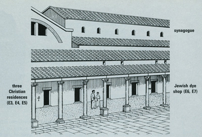
In 1996, Hershel Shanks, Editor of Biblical Archaeology Review, asked me to illustrate an article by John S. Crawford, entitled “Multiculturalism at Sardis” (BAR, Sept/Oct 1996 pp. 38 – 47). This involved drawing up a complex dating from the Byzantine period, which had been excavated in the city (originally mentioned as one of the 7 churches of Revelation). The complex comprised a colonnade of shops, some owned by Jews and some by Christians, an adjacent synagogue and adjoining this, an elaborate bath-gymnasium, with a marble forecourt:

He also requested a detailed drawing of the shops, where symbols carved on the stones revealed the differing religious affiliation of the owners. The whole point of the article, was, as its title implies, to show how Christians and Jews lived in Sardis side by side, in full tolerance of each other. I distinctly remembered drawing the two menorot incised on the doorjamb of the shop identified as belonging to Jacob the dyer. On the drawing, the two menorot are drawn on the outside of the shop, although in reality they are carved on a stone of the inside door jamb:
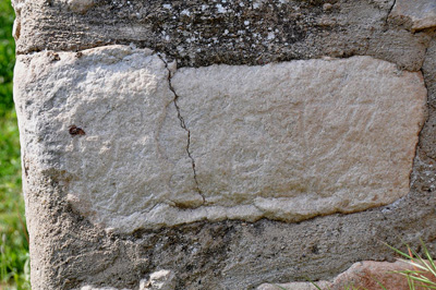
On our recent visit to the site, however, there was no indication of these evocative symbols, only numbers labelling each shop. Knowing that they must be there, we peered and felt around and it was deeply satisfying to find one and then another lampstand carved into the stone, just as I had drawn them up from original photos, taken by the Harvard-Cornell excavations in the 1960s and 70s. A large menorah can be seen on the right side of the stone, while a smaller one is visible to the left of the same stone:
We were blown away by the richness of Turkey’s Biblical heritage and are astounded at the recent direction taken by the country. Whither the “Other Holy Land?”

GLO Easter Experience

The new digital GLO Bible illustrates the events surrounding the Passion Week of Jesus Christ with samples of the media that accompanies scripture. Some of the reconstructions and animated maps that are shown are based on designs by Ritmeyer Archaeological Design:

The Palatial Mansion, excavated by Prof. Nahman Avigad in the Jewish Quarter of the Old City of Jerusalem, may have been the Palace of the High Priest where Jesus stood before Caiaphas, the son-in-law of Annas.

A 2,000 year old Mikveh exposed in the Western Wall tunnels

While I was abroad, the IAA reported that a 2,000 year old mikveh has been found near the Temple Mount:

“The miqve was discovered inside the western hall of a splendid structure that is located just c. 20 meters from the Western Wall. Parts of the building were discovered in the past and the Israel Antiquities Authority is currently exposing another one of the three halls inside it. It is one of the most magnificent structures from the Second Temple period ever to be uncovered.”

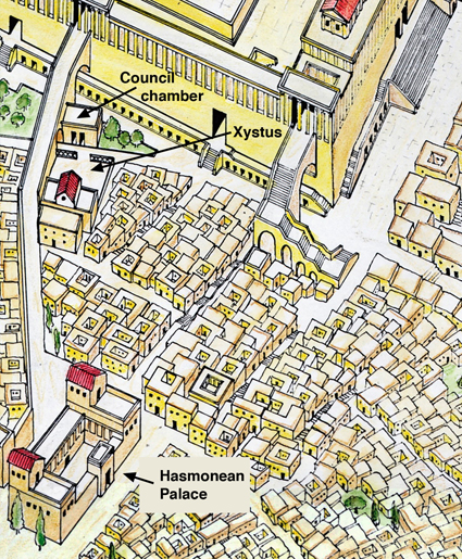
This “magnificent structure” is the Council-chamber, also known as the Masonic Hall, which was first discovered by Charles Warren in the 1860’s. It is located near the Western Wall and the bridge over Wilson’s Arch was later partly built over it. This drawing shows the location of the Council-chamber, the Xystus and the Hasmonean Palace in relation to the Temple Mount:

Xystus

The confusing part in the rest of this report is the following sentence:

“In his book The War of the Jews, Josephus Flavius writes there was a government administrative center that was situated at the foot of the Temple. Among the buildings he points out in this region were the council house and the “Xistus”- the ashlar bureau. According to the Talmud it was in this bureau that the Sanhedrin – the Jewish high court at the time of the Second Temple – would convene. It may be that the superb structure the Israel Antiquities Authority is presently uncovering belonged to one of these two buildings.”

Josephus actually writes the following about the northern part of the First Wall in The War of the Jews 5.144:
“Beginning on the north at the tower called Hippicus, it [the city wall] extended to the Xystus, and then joining the council-chamber terminated at the western portico of the temple.”

The Xystus was not a building, but a paved open space for assembly, used for public speeches. In Greek, xystus means smooth, polished flag-stones. Previously, the Gymnasium was located there. In The War of the Jews 2.344, Berenice stood watching on the roof of the Hasmonean Palace, while King Agrippa made a speech to the people which he had summoned to the Xystus below. If they were inside a building, Berenice could never have watched this event. It is therefore a mistake to confuse the Xystus with the “ashlar bureau”, better known as the Chamber of Hewn Stone (Lishkat haGazit in Hebrew) of the Mishnah.

The Council-chamber (Bouleh in Greek) was located between the Xystus and the Western Wall of the Temple Mount. It was a public building and has nothing to do with the Chamber of Hewn Stone, which was located on the Temple Mount. It is described in Mishnah Middot 5.4 as one of the chambers of the Temple Court: “Those [chambers] on the south were the Wood Chamber, the Golah Chamber and the Chamber of Hewn Stone.” “The Chamber of Hewn Stone – there used the Great Sanhedrin of Israel to sit and judge the priesthood.” See also my previous post on The Sanhedrin and the Temple Mount.

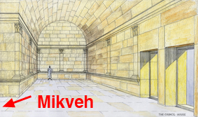
The archaeologist Alexander Onn correctly calls the Council-chamber a government administrative building. The mikveh with its 11 steps was built later into the building, testifying to the growth and development of Jerusalem later on in the Herodian period.

The Council-Chamber was a beautifully designed building with pilasters cut into the interior walls, resting on a plinth which was located about 1 meter (3 feet) above the original floor. The newly discovered mikveh is located in the western hall of this building, well below the original floor level. Below is my reconstruction drawing, showing the location of the mikveh:
mikvehtn

Building a Sacrificial Altar on Tisha B’av

Here is some really exciting news for those who are watching Temple Mount events. Arutz Sheva, a daily news report from Israel, reports that the Temple Institute plans to build an altar on Tisha b’Av – the 9th day of the Jewish month called Av. That is tomorrow, at 5.30 pm on Thursday 30th of July.
The stones for the Altar were gathered from below the water line of the Dead Sea, wrapped in plastic and transported to Mitzpe Yericho, located some 15 miles east of Jerusalem, as can be seen in this report. According to Yehudah Glick, the Temple Institute director, the altar will be kept small, so that eventually it could be transported to the Temple Mount. According to him this is the “ideal time to begin to build the Temple.” It will be interesting to see when that happens.

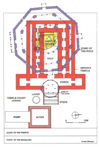
The historical location of the altar on the Temple Mount was just to the east of the Dome of the Rock. We reported on this location in a previous post, when we published a section through the Dome of the Rock and the Temple of Herod the Great. Today we publish a plan of the location of the Altar in relation to the Dome of the Rock, which is one of the slides in our latest CD, In Search of Solomon’s Temple:
Temple Plan Coltn
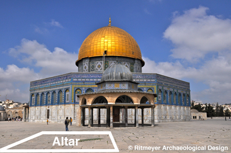
Not everybody finds it easy to understand plans, so here is a view of the Dome of the Rock from the east, looking west, with the historical location of the altar indicated:
Altar
We can hardly imagine the day that again an altar will be built on the Temple Mount!

Solomon’s Temple and Herod’s Temple Mount

This is a post I am thrilled to be able to write! Followers of this blog will know that over the years, we produced educational slide sets that lecturers and teachers used to give presentations or to enhance their own presentations. We updated two of these to CD format and many of you wrote to say how helpful you found these. In fact, we received many communications begging us to transform the remaining slide sets into CDs. Pressure of other projects delayed this until recently, when further CDs were requested for a lecture tour.

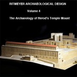
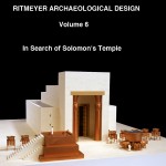
We are pleased therefore to inform you that two more of these are ready, in time for the beginning of the academic year: Volume 4: The Archaeology of Herod’s Temple Mount and Volume 6: In Search of Herod’s Temple Mount. Do click on CDs under Product Categories to have a look.

Vol 4 web

Vol6 web

If you follow Temple Mount matters, you will know that this coming Thursday, July 30th, is Tisha be’Av, (the ninth day of the Jewish month Av), which commemorates the destruction of both the First and Second Temples on this same date (the First by the Babylonians in 586 B.C., the Second by the Romans in 70 A.D.). With the help of these presentations, you can, wherever you are, “Walk about Zion, and go round about her: tell the towers thereof. Mark ye well her bulwarks, consider her palaces; that ye may tell it to the generation following” (Psalm 48:12,13).

Hopefully, we will soon post news of the remaining two CDs.

A new Bible program

During the last eight months or so, we have worked as archaeological and historical consultants for a new digital Bible program, called GLO.

On the introductory page of the new website, it says: “Glo is an interactive Bible with a world of media, resources and tools to help you get closer to the Word of God”. The program will soon be available. GLO will prove to be very helpful for the Bible student who wants to know more about the Bible and the physical background on which the stories are played out.

Through 5 main “lenses”, Bible, Atlas, Timeline, Media and Topical, the Bible student will be able to browse the contents of this very useful program.

There are numerous virtual tours, high-res photos, vidoes, articles and maps which help bring the Bible to life. You can even share your personal notes with friends online.

More information will follow.

German Lecture Tour

From June 19-27, 2009 a lecture tour in Germany has been planned. My wife Kathleen will join me.

The first series will take place on June 19, 20 in Schwäbisch Gmünd, for see details here.
The lecture titles are:
1. Reconstruction of Herod’s Temple (Saturday 20, 9.30 – 11.30)
2. In Search of Solomon’s Temple (20.00 – 22.00)

Next some lectures will be given at the Freien Theologischen Hochschule (FTH) Giessen
(Giessen School of Theology) on June 23 and 24. The three lectures are entitled:
1. The Role of the Herodian Temple in Jerusalem (23 June, 11.10 – 13.00)
2. The Archaeology of the Temple Mount in Jerusalem (June 23, 19.30 – 21.15)
3. Solomon’s Temple in the Books of Kings and Chronicles (June 24, 14.10 – 16.00)

Finally, two lectures will be given at the Saxon Conference for the German Friends of Israel at the Pavillon of Hope, Puschstr. 9, Leipzig on Friday 27th (15.00) and the titles are:
1. What did Herod’s Temple Mount look like?
2. Where on the Temple Mount stood Solomon’s Temple?

Free online version of the ESV Study Bible

During the month of March, anyone can access the ESV Study Bible for free at this website:
http://www.esvstudybible.org/online
It was a privilege to have worked on this wonderful project. This is what Justin Taylor (Project Director) wrote:
“The ESVSB was published just over four months ago and there are already 300,000 copies in print. We give God the honor and the praise, and we pray that God would use this resource to help edify and build up his church.”

The Antonia, Herod’s Temple Mount Fortress

In the Jan/Feb 2009 issue of Biblical Archaeology Review, an article was published by Ehud Netzer, called “A New Reconstruction of Paul’s Prison”. Netzer is a respected and successful architect/archaeologist and well-known for his excavations of Herodium and Hasmonean and Herodian Jericho and other Herodian sites. Recently he amazingly found the long-lost tomb of Herod the Great.

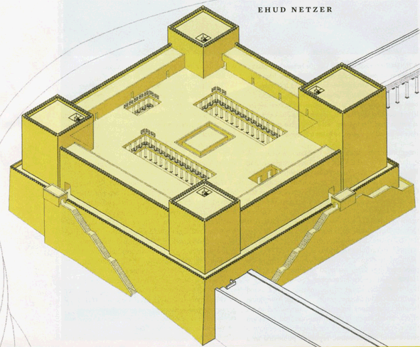
In the last few years he also tried, less successfully in my opinion, to reconstruct Herod’s Temple Mount. His reconstruction proposal for the Antonia Fortress is a clear example of ignoring important historical sources and archaeological evidence. Here is his reconstruction:

As far as historical sources are concerned, Josephus (War 5.238-246) wrote that “The tower of Antonia lay at an angle where two porticoes, the western and the northern, of the first court of the Temple met; it was built on a rock fifty cubits high and on all sides precipitous.”

The reconstruction of Netzer does not meet these two historical requirements. The northern and western porticoes don’t meet and no rockscarp is to be seen in Netzer’s drawing on the south and west sides. Indeed, there never were precipitous rockscarps in the area occupied by the southern and south-eastern part of his reconstruction.

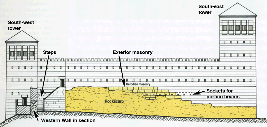
There is archaeological evidence that the two porticoes did in fact meet. Sockets for the roof beams of the northern portico can still be seen today in the northwest corner of the Temple Mount, see Ritmeyer, The Quest, Revealing the Temple Mount in Jerusalem, p. 130), see:

These sockets were placed in exterior Herodian masonry, which is visible high above the still-existing rockscarp. This masonry consists of ashlars with the typical Herodian margins, which were used for exterior masonry only. This proves that this rockscarp with its Herodian masonry was an external wall, namely the southern wall of the Antonia Fortress and not an interior wall. This also shows that the northern portico of the Herodian Temple Mount ran in front of the southern facade of the fortress, enabling it to “meet” with the western portico, as described by Josephus.

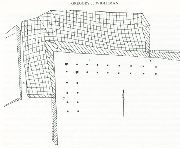
Netzer places the south-western corner of the fortress at small projection in the Western Wall. This projection exists, possibly because of the lay of the bedrock, but it is too insignificant a projection for the south-west tower of the Antonia. There is a much larger projection to the north, which is completely ignored by Netzer. It can be seen in the western side of the north-west corner of the Temple Mount and at the end of the Western Wall Tunnel. This projection has been mapped by Gregory Wightman (Temple Fortresses in Jerusalem, BAIAS, Vol. 10, pp. 7-35) in this diagram:

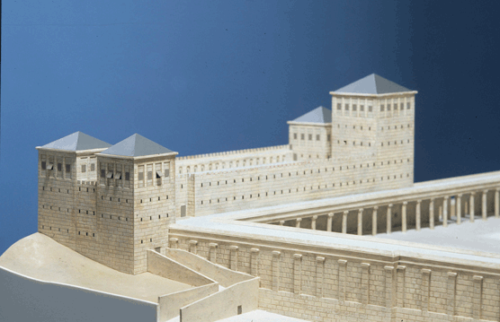
It shows that the south-west tower projected much more from the Western Wall than shown in Netzer’s reconstruction. All of these historical and archaeological data, ignored by Netzer, have been incorporated into my own reconstruction of the Antonia Fortress as shown in this model:

Original Herodian paving stones were, until recently, visible in the north-west corner of the Temple Mount. Netzer’s reconstruction does not relate to this pavement. Netzer’s Antonia plan is square, although the north-west corner of the Temple Mount is in fact not a right angle, but an acute angle of approximately 86 degrees.

In 1975, P. Benoit (The Archaeological Reconstruction of the Antonia Fortress, Jerusalem Revealed, 1976) has brilliantly shown that the Antonia was located exclusively on the rockscarp at the north-west corner of the Temple Mount. Prior to this time, several scholars, such as De Vogüé and Vincent, had promoted a larger Antonia which projected inside the Temple Mount. It is a pity to see that Netzer has regressed to that earlier and by now obsolete reconstruction of the Antonia Fortress.

Temple Mount Mikveh

Zachi Zweig, an archaeologist who is involved with the Temple Mount Sifting project, kindly send me the paper [in Hebrew], which he gave at the recent conference on the Temple Mount at the Bar-Ilan University. I commented on this find in an earlier post. Here is an abstract:

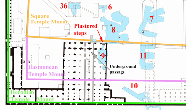
“Hamilton describes the discovery of a plastered cistern that was excavated below the easternmost door of the present El Aksa mosque, north of Cistern 9 [according to Warren’s numeration – see map]. The descent to [the cistern] was from west to east by means of a flight of steps, with the bottom step some 3 m. [10 feet] below the present floor of the mosque. The remains of some five steps were discerned, which were built against a plastered wall, which was about 90 cm wide [3 feet].

Unfortunately, Hamilton did not publish additional details – not one picture or plan. However, in the Mandatory Archives there was a photograph of the five steps, which descend to the opening of the cistern. The top of the steps is located some 1.50 – 2 m. [6-7.5 feet] below the present surface and to the south of it and adjacent to it, although at a little distance, there is a thick wall. This is most likely the same cistern. The steps appear to have been cut out of the rock and this points to the fact that the level of the top of the rock in this location is at about 1.50 m. [6 feet] below the level of the present pavement.”

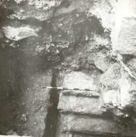
The exit of the cistern is located deep below the level of the floor of the mosque. Hamilton dated it to the late Roman period. However, as the remains of a dividing wall can be discerned, Zachi concluded that it could have been a mikveh (Jewish ritual bath), see picture below:

It is located a little to the east of the underground passage which leads up from the Double Gate to the Temple Mount. Ronnie Reich has identified Cistern 6 and 36 as mikva’ot, but these are located in the original Square Temple Mount. These could have been added in the Second Temple period, as they are located close to the surface and no First Temple period mikva’ot are known.

This latest one, however, is located much lower down and in the Hasmonean extension of the Temple Mount and may therefore have been one of the earliest mikva’ot in Jerusalem:
Worshipers in the Hasmonean period, who had not purified themselves before going to the Temple Mount, perhaps had the opportunity to do so in this mikveh, if it was a mikveh indeed.