Ivory pomegranate found in City of David excavations

Joseph Lauer passed on this interesting information:
“Dr. Eliot Braun noted on the ANE-2 list that the January 9, 2009 Ha’aretz Hebrew online edition has an illustrated report about the discovery in the City of David excavations led by Dr. Ronny Reich and Eli Shukron of a miniature ivory pomegranate and a bulla (among over 170 other bullae found in the excavations).
The article, which has not yet appeared in Ha’aretz English online edition, may be read here.
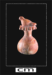
picture of the pomegranate

Also on the ANE-2 list, Dr. Victor Avigdor Hurowitz has taken issue with certain statements made in the article, including “that the pomegranate found in the City of David is similar in form to the 400 decorative pomegranates which are described in Solomon’s Temple according to the book of I Kings 7:43 (should be v. 42 and cf also v, 20!)”. Calling this “absolute nonsense”, he points out that “The pomegranates in the temple descriptions were part of the Yakhin and Boaz pillar crowns which were made of bronze and not ivory as is the new pomegranate.” With regard to the dove sitting on the pomegranate, he writes that I Kings 7 “doesn’t describe the pomegranates at all, let alone the doves on top of them, unless we somehow take hassebakah mentioned along with weharimmonim as a corruption of hassobek (dove coop).” He concludes that “At most one can say that the newly discovered pomegranate can be, like pomegranates mentioned in various biblical passages, a decorative motif known also from cultic contexts.” See here.
Additional ANE-2 postings have been made. I’m sure that many more articles and postings will follow.”

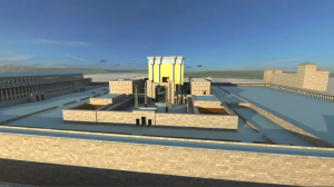
The Messiah in the Temple

The Messiah in the Temple is an exciting project with the aim of developing a 3-D visual media of the Temple of Jerusalem. This project was conceived by the project manager Martin Severin. After reading Roger Liebi’s book of that name and my book “The Quest – Revealing the Temple Mount in Jerusalem”, he decided with the help of Christof Frank of digi mice GmbH to make a digital version of the reconstructed Herodian Temple Mount.


Click here to view video

You can read more about the project on the The Messiah in the Temple website, where you can also download a larger video file.
Thanks to Justin Taylor, you can watch the video on YouTube:

The Temple Mount and the National Geographic

In May this year, I was asked to join the National Geographic team on a poster supplement for the December Issue of the magazine. The subject of the poster was the history and architecture of the Temple Mount. I had the opportunity to meet with Fernando Baptista and Patricia Healy (NGS Senior Graphics Editor and Art Researcher respectively) in New York during a conference on “The Temple of Jerusalem: From Moses to Messiah”. See my earlier post.

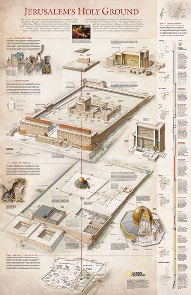
They wanted my help with the creation of a NG poster on the Temple Mount and also came to see the models I had designed and which were then on show in the Yeshiva University. This interesting poster is now available in the December issue. The poster is called “Jerusalem’s Holy Ground” and shows, from top to bottom, the Binding of Isaac, The Rock, Solomon’s Temple, Herod’s Temple Mount and the Temple Mount during the Early Muslim period. It also shows cut-away drawings of Solomon’s Temple, Herod’s Temple and the Dome of the Rock and has a timeline on the side. The other side of the poster shows a magnificent map of the Eastern Mediterranean region, named “The Crucible of History”. The poster is beautifully produced and it is worthwhile getting the National Geographic December issue if you don’t have a subscription. The magazine has for its main theme, The Real King Herod, architect of the Holy Land.

Here is a view of the poster, reproduced with permission of the National Geographic Society:

The Temple of Jerusalem and the Colosseum

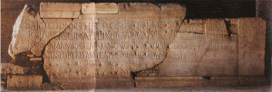
One of the readers of my blog commented on an interesting connection between the Colosseum and the Temple of Jerusalem, mentioning that Prof. Louis Feldman had discovered an interesting inscription in the Colosseum in Rome. This is the stone with the inscription:

I met Prof. Feldman when I was in New York earlier this year. He did not claim to have discovered or deciphered the “ghost” inscription, for that was done by the renowned scholar Gezah Alfoldy. Feldman wrote an interesting article for BAR (July/August 2001), in which he explained how Alfoldy arrived at his conclusion. The inscription in question was carved in Latin on a stone, which is displayed in one of the entrances to the theater. This stone once carried an earlier inscription. That inscription was made of metal (probably bronze) letters which were fastened to the stone with pegs. The holes for the pegs are still visible on that stone. Alfoldy used the location of the peg holes to reconstruct the inscription and came to the conclusion that it commemorated the building of the Colosseum by Titus from the spoils of war. Feldman then suggested that the war in question might have been the Great Jewish Revolt against Rome, which resulted in the destruction of the Temple in 70 A.D.

Temple Mount Mikveh

Zachi Zweig, an archaeologist who is involved with the Temple Mount Sifting project, kindly send me the paper [in Hebrew], which he gave at the recent conference on the Temple Mount at the Bar-Ilan University. I commented on this find in an earlier post. Here is an abstract:

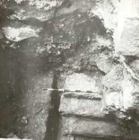
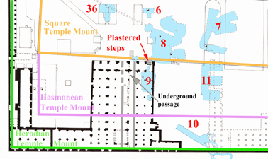
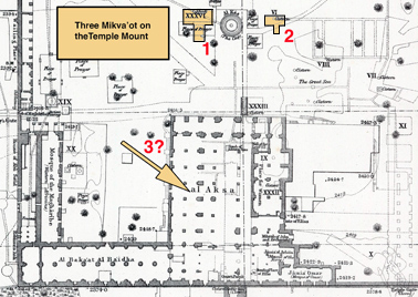
“Hamilton describes the discovery of a plastered cistern that was excavated below the easternmost door of the present El Aksa mosque, north of Cistern 9 [according to Warren’s numeration – see map]. The descent to [the cistern] was from west to east by means of a flight of steps, with the bottom step some 3 m. [10 feet] below the present floor of the mosque. The remains of some five steps were discerned, which were built against a plastered wall, which was about 90 cm wide [3 feet].

Unfortunately, Hamilton did not publish additional details – not one picture or plan. However, in the Mandatory Archives there was a photograph of the five steps, which descend to the opening of the cistern. The top of the steps is located some 1.50 – 2 m. [6-7.5 feet] below the present surface and to the south of it and adjacent to it, although at a little distance, there is a thick wall. This is most likely the same cistern. The steps appear to have been cut out of the rock and this points to the fact that the level of the top of the rock in this location is at about 1.50 m. [6 feet] below the level of the present pavement.”

The exit of the cistern is located deep below the level of the floor of the mosque. Hamilton dated it to the late Roman period. However, as the remains of a dividing wall can be discerned, Zachi concluded that it could have been a mikveh (Jewish ritual bath), see picture below:

It is located a little to the east of the underground passage which leads up from the Double Gate to the Temple Mount. Ronnie Reich has identified Cistern 6 and 36 as mikva’ot, but these are located in the original Square Temple Mount. These could have been added in the Second Temple period, as they are located close to the surface and no First Temple period mikva’ot are known.

This latest one, however, is located much lower down and in the Hasmonean extension of the Temple Mount and may therefore have been one of the earliest mikva’ot in Jerusalem:
Worshipers in the Hasmonean period, who had not purified themselves before going to the Temple Mount, perhaps had the opportunity to do so in this mikveh, if it was a mikveh indeed.

Jerusalem and Rome

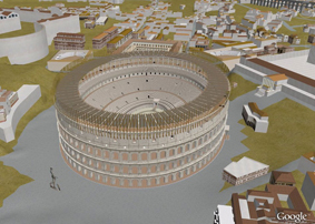
Google Earth have brought out an exciting “Fly into Rome as it looked in 320 A.D.” animation. You can see it here. Below is a snapshot digital reconstruction of the Colosseum:

If you don’t have Google Earth, you can download it for free here.

With thanks to Justin Taylor, who alerted me to this.

Third Jewish Mikveh and a Byzantine Mosaic floor discovered on the Temple Mount

It was reported in the Jerusalem Post that during the recent Rennert/Bar-Ilan University’s conference on “New Studies on Jerusalem”, Zachi Zweig pointed out that during reconstruction work at the El-Aqsa mosque in the 1930’s, the remains of a Byzantine mosaic floor and a mikveh (Jewish ritual bath) were discovered. The mikveh was located below the Byzantine floor.

This is an important discovery and will change our views on the history of the Temple Mount. The mosaic floor may or may not have belonged to a church. More information is necessary before deductions can be made about the nature of the building, but the mosaic pattern possibly indicates a public building.

The mikveh would be the third we know of on the Temple Mount, as two other ones have been identified previously by Ronnie Reich. He based his proposal on the shape of the shape of Cisterns 6 and 36 (1 and 2 on Warren’s map of the Temple Mount below). The exact location of the newly published mikveh (3) inside the El-Aqsa mosque is not yet known. However, this nevertheless proves the Jewish origin of the Temple Mount.

Source: Joe Lauer

First Temple Period Hebrew Seal found

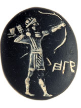
It is always exciting when an Hebrew seal of the 7th Century B.C. is found, as announced today here. In an excavation 100 m west of the Western Wall an impressive seal was found. It shows a Hebrew archer in Assyrian style military outfit and his name, Hagab, engraved in ancient Hebrew script next to him. At least he doesn’t look like a grasshopper, which the Hebrew meaning of this name is. The name appears in reverse, so that it would come out right, when impressed in clay.

It was stated that this name of Hagab also appears in the Bible, namely in Ezra 2.46. That is where the comparison ends, of course, for this Hagab was one of the Nethinim, temple servants. Temple servants were not usually dressed in warrior’s suits.

The seal was found in an excavation, located some 100 m. from the Western Wall. This wall, of course, did not exist at the end of the First Temple period. The Western wall at the end of the First Temple period was located at least 25 m further to the east. That wall was part of the 500 cubit square Temple Mount, which was probably built a century earlier by King Hezekiah.

King Solomon’s Copper Mines

Excavations in Jordan have revealed copper mines that were in use during the 10th Century B.C., i.e. the time of King David and Solomon. The site is called Khirbat en-Nahas, which means ‘the ruins of copper’. The massive smelting plant was probably operated by King Solomon, who may have derived part of his wealth from this site, just a King Herod the Great amassed huge wealth from the mining of copper in Cyprus. The site has also revealed some Egyptian artifacts, which may be related to the invasion of the Egyptian Pharaoh Sheshonq (Shishak of the Bible), soon after Solomon’s death. You can watch an interesting video here about these excavations, which were led by Thomas Levy of the University of California in San Diego.


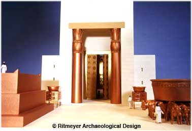
Huge amounts of bronze, an alloy of copper and tin, were used in Solomon’s Temple for the two pillars, Yachin and Boaz, the Altar, the Great Sea and other installations, as shown in this model of Solomon’s Temple.

Some scholars have cast doubt on the existence of the fabled King Solomon, because of the few remains of the 10th Century B.C. that have been found, especially in Jerusalem. However, when King Hezekiah created a new artificial platform around the renovated Temple, the remains of Solomon’s Royal Complex, such as his Palace and the House of the Forest of Lebanon, may have been dismantled and therefore will never be found. It does not mean, of course, that they never existed.

Jerusalem – reconstruction drawings in the various periods

Our new line of downloadable images has proven to be very successful. It is a great way to download the reconstruction drawings or model images you need for your powerpoint presentation and you can have them immediately. And our clients are asking for more. The latest images available are reconstruction drawings of the City of Jerusalem in the various periods.

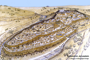
1. The City of Solomon drawing (above) was the first reconstruction to incorporate the massive fortifications that have been uncovered near the Gihon Spring. No wonder that this was the place where Solomon was anointed king. Another first in this drawing is the interpretation of the Spring Tower as part of an additional gateway to the city on the east, so that to get into the city from this direction, one had to pass through two gate systems.
2. The next drawing is more schematic, as it shows how Jerusalem developed in the Biblical period or Iron Age. It shows at bottom left the City of David as he had conquered it from the Jebusites and rebuilt it. On the right of the drawing one can see how Solomon, by building the first permanent sanctuary in Jerusalem, extended the city to the north, doubling its size.
The top part of the drawing shows Hezekiah’s expansion of the city by building a city wall around the south-western hill. This was given expression in Ps. 122.3, “Jerusalem is a city that is joined together” or, as the ESV has it “Jerusalem—built as a city that is bound firmly together”. A section of this wall has been excavated in the Jewish Quarter of the Old City and called “The Broad Wall”.
3. Jerusalem in 30 A.D. This drawing was first made for The Times Atlas of the Bible and later made available as a poster. It shows Herodian Jerusalem at its peak with landmarks indicated such as the Temple Mount (of course), the Herodian and Hasmonean Palaces, the Bethesda and Siloam Pools and two alternatives for Golgotha.