I hope that my presentation will provide a fruitful focal point for collaborative work between those of other disciplines who are trying to understand the site.
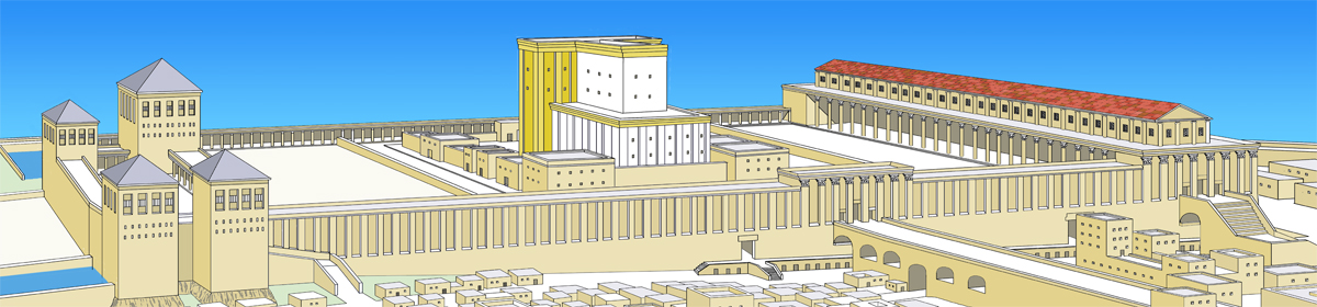
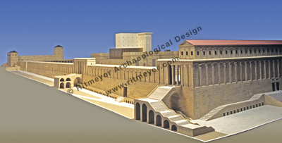
I am also glad to say that we are not any longer in the realm of imagination. Apart from the historical sources (Josephus, the New Testament and the Mishnah), we have the results of the daring investigations of explorers of the 19th and 20th century. The massive excavations south and west of the Temple Mount, following the 6-Day War in 1967, provided information on the outer frame of the Temple platform. And in the absence of excavations on the mount itself, (none is foolhardy enough to attempt this, as it would start another Mid-East war!), research into surface traces preserved there has yielded results that add detail and complete the picture. Our depiction cannot be an exact reproduction of the structure that existed in Jerusalem in the time of Christ, but hopefully it approximates to what only an imaginary time tunnel could show.
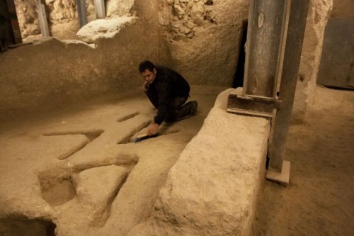
In yesterday’s post, we reported on the large mysterious V-shaped marks found in the City of David Excavations:
The announcement by Eli Shukron that he was puzzled by the marks, brought an enormous response from people who had all sorts of different suggestions. The Jerusalem Post reported that more than 20,000 people had responded:
Among the most interesting ideas: a torture device, drainage for ancient urinals, the original McDonald’s sign, an abbreviation for “veni vidi vici” (Latin for “I came, I saw, I conquered”), a footprint from King Solomon’s pet dinosaur, molds for smelting iron to make tools, the Trinity, a representation of mountains or the symbol for water, signs to the exit, an alien cryptogram, or support for a wooden structure.
Here in the UK, BBC 4 aired an interesting program on Jerusalem with Simon Sebag Montefiore, author of “Jerusalem, the biography“. The first part of a series can be seen in the UK on BBC iPlayer. Here is a good review of his book.
Arutz Sheva (Israel National News) has a report on illegal Muslim burials at the Ophel Corner, near the southeast corner of the Temple Mount. It appears to be part of an illegal land-grab.
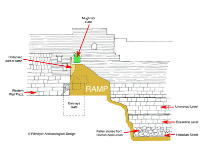
Jerusalem City engineers have ordered that the ramp to the Mughrabi Gate be closed indefinitely for safety reasons, although there may be political reasons behind the move, i.e. to force the Israel government to build a new bridge despite international pressure to refrain from upsetting the Arabs.
Some members of the Knesset (Israel’s Parliament) have called for an alternate access for Jews to visit the Temple Mount (what about the tourists)?
The Mughrabi Ramp partly obscures the Herodian Barclay’s Gate. We commented on the problems of the ramp in previous posts, such as this one, containing a diagram:
In my latest blog post, I tried to show how the Temple Mount may have developed after the death of Herod the Great. This post was written in the wake of the discovery of four coins from the time of the Roman procurator Valerius Gratus (17/18 AD) below the Western Wall as described previously.
Now, a Palestinian “archaeologist”, Dr. Jamal Amro, claims that he was the one who found the 17 (not 4) Roman coins! He rightly states that the coins date from the time of Valerius and then draws the illogical and ridiculous conclusion that:
“All archaeological discoveries that were found before this one in the Arab city of Jerusalem and around the Aqsa Mosque date back to ancient Arab and Islamic eras especially the times of Umayyad and Abbasid reigns (661-1258) up to the Ottoman rule (1520 AD)”
He also stated this discovery left the Jewish archaeologists in a state of shock and frustration because it just proved further their false claims and beliefs about the legend of the temple.
The sad thing is that instead of laughing Amro off the stage, his statements are being parroted all over the world and incorporated into the Arab Narrative, perhaps to become an official UNESCO policy statement. Googling the headline “Archaeologist rebuts Jewish claims about their alleged temple” demonstrates how quickly and easily foolish lies can be spread in our day.
The latest archaeological developments near the Western Wall of the Temple Mount (see my previous post) have caused concern to some who feel that their understanding that King Herod the Great built the Temple Mount in Jerusalem is being undermined. It would mean that the Temple Mount was not finished when Jesus visited the Temple. That, however, does not have to be the case.
It took several decades to complete this massive Temple Mount. I will always call it Herod’s Temple Mount, as he was the originator of its plan and began its construction. Todd Bolen pointed out in his latest blogpost: “Josephus reported that in AD 64 work was halted on the Temple Mount and 18,000 workers were laid off (Ant. 20:219-23).” Such large projects take a long time to complete. It was started in the reign of Herod the Great, but continued during the time of his sons and grandsons. It is possible that the Temple Mount was never totally completed.
The problem of how and when the Temple Mount walls were built is very complex. There are architectural features that indicate that the Temple Mount walls were built in stages over a considerable period of time, although within a time span of less than 100 years. I don’t as yet have all the answers, but focussing on the Western and Southern Walls, the following points need to be taken into consideration:
1. The south end of Robinson’s Arch is keyed into the stones of the Western Wall, but its northern end is NOT:
These drawings show the different treatment of how the north and south ends of Robinson's Arch were keyed into the wall.
This means that, at some stage, the upper part of the Western Wall was built from a point to the north (possibly Wilson’s Arch) to the location where they planned to build Robinson’s Arch (see the straight joint in the drawing on the left). The arch and perhaps the southwest corner must have been built later (see The Quest – Revealing the Temple Mount in Jerusalem, p.46). This means that in 20 AD (see previous post), the southern part of the Western Wall was not yet completed.
2. However, this would leave enough time (10 years) for the southern part of the Temple Mount to be finished by around 30 AD, when Jesus and his disciples visited the Temple.
3. The street complex below Robinson’s Arch was built later (perhaps 50 AD), as coins from the time of Agrippa II were found below the paving stones.
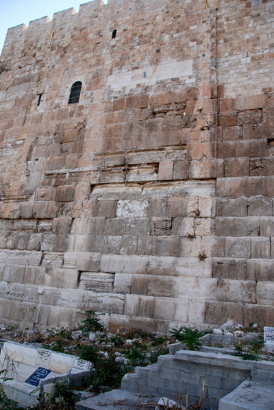
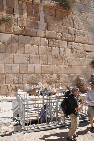
4. The stones of the Western Wall below Robinson’s Arch have rough bosses below street level. That is also the case near Barclay’s Gate, but not to the north of this gate. The stones of the Southern Wall, from the southwest corner to the Double Gate have also rough bosses below street level, but they don’t appear in the east part of the Southern Wall. Warren wrote (Survey of Western Palestine, Vol II, Jerusalem, p. 191):
“From the two shafts sunk at Wilson’s Arch and at Barclay’s Gate, it is obvious that the Sanctuary wall is for this portion built up from the bottom with drafted stones with well-cut faces. But to the south of the retaining wall at Barclay’s Gate, at the south-west angle and round the south-west angle to the Double gate, the stones have rough projecting faces up to the level of the pavement under Robinson’s Arch, that is, up to Course P, or to about 23 feet 6 inches above the rock at Barclay’s Gate, the sill of the gate being about 50 feet above the rock. From this the inference may be drawn that the wall south of Barclay’s Gate is of later date that that to the north, and was not commenced till the valley had begun to fill up about 23 feet 6 inches at this part. In this case the retaining wall may have been one side of a ramp or viaduct leading across the valley to this Suburban gate, at a height of 27 feet above the surface of the ground at that time.”
5. Two fallen voussoirs are lodged in the drain below Robinson’s Arch, showing that part of the arch fell down during its construction (see pictures in this previous post).
6. The two eastern domes of the Double Gate passageway (barely visible on the right in the drawing below) also fell down at some time during the First Century AD and were built up again without decorations. (The western domes are still decorated). It is not clear if this happened before or after the Royal Stoa was completed.
At present, I see the following sequence in the building of the southern part of the Temple Mount (only four of the stages are illustrated below):
a. Herod, in his lifetime, completed the lower part of the Western Wall from the Antonia Fortress up to Barclay’s Gate, that is as far south as the Hasmonean extension of the square Temple Mount goes (see this previous post). The portico on top of the wall may only have been completed from the Antonia up to the gate over Wilson’s Arch, as that is where the First Wall was connected to the Temple Mount.
b. The part of the Western Wall that lies below the street, from Barclay’s Gate up to the southwest corner and then up to the Double Gate in the Southern Wall, was built with rough bosses in or soon after 20 AD. Because the southwest corner of the Temple Mount crossed the Tyropoeon Valley and cut the drain below the planned street, an arched relay section was built to connect the drain again. The Western Wall with the rough bosses was built up to the level of the planned street:
c. The Tyropoeon Valley was then (20 AD), filled up to the level of the rough bosses from Wilson’s Arch to Barclay’s Gate.
d. The top of the Western Wall was built from the gate over Wilson’s Arch to the north side of Robinson’s Arch:
e. Robinson’s Arch and the Double Gate in the Southern Wall with the wall in between were built later, possibly sometime around 30 AD.
f. Part of Robinson’s Arch fell down (and perhaps also Wilson’s Arch) and the two eastern domes of the Double Gate passageway were destroyed (The Quest, p. 74) – possibly by an earthquake?
g. The underground passageway of the Double Gate was repaired, the southwest corner with Robinson’s Arch and stairway completed and the Royal Stoa finished.
This proposal for the development of the Herodian Temple Mount is only in its early stages, but I hope that it may be helpful to those who struggle to understand the implications of the latest archaeological discoveries near the foundation of the Western Wall.
The announcement of the new theory on when the Western Wall was built (see here and here) was not as dramatic as expected. The discovery of coins, the latest of which were struck by the Roman procurator Valeruis Gratus in 17-18 AD, in a mikveh that went out of use when the Western Wall was built over it, suggests that the building of the Temple Mount walls took decades. This is the full report released by the Israel Antiquities Authority.
A picture of the two coins that were found in the mikveh. The coins date from the time of the Roman procurator Valeruis Gratus (17-18 AD). Photo: Vladimir Neichin/IAAThis picture shows that the Western Wall was built over the remains of a mikveh. Photo by Vladimir Neichin/IAAPhoto of the excavation of the mikveh by Vladimir Neichin/IAA
This late date is not surprising, as at the beginning of Jesus’ ministry, usually dated to 30 AD, it was said that this Temple complex had been in building already for 46 years (John 2.20).
At the northern end of the Western Wall is a piece of bedrock that wasn’t even removed before the Temple was destroyed by the Romans in 70 AD.
This doesn’t mean to say that the Western wall is not Herodian. The whole building concept was designed by Herod the Great and completed after his death.
The Spokesperson of the Israel Antiquities Authority “circulated an invitation to journalists to attend a press conference tomorrow (Wednesday, November 23, 2011) at which “A find will be presented that challenges the conventional viewpoint in archaeology regarding the construction of the Western Wall of the Temple Mount.”
Although it sounds mysterious, Ronny Reich, whom I met very recently in Jerusalem, said that he has new information about the construction date of Robinson’s Arch. It will be interesting to see what he has to say.
In the previous post we mentioned the opening of the Herodian sewer in Jerusalem. One can now walk underground from the Siloam Pool to the Temple Mount. Last week, we were one of the first groups to walk through this drain/sewer, that collected the rain water that fell on the street and drained the sewage from the adjacent buildings. Here is a photographic record of the tour:
Don’t fear, the sewer is dry! One can now walk underground through the full length of the 2,000 year old Herodian drainage channel that ran below the street from the Siloam Pool to Robinson’s Arch near the Temple Mount. The route of the street is indicated on the drawing below:
Tom Powers has an excellent description using recent photographs and my map of this drainage system that I used in a previous blog post to explain its construction during the Hasmonean period and the Herodian bypass that was made after the construction of the southwest corner of the Herodian Temple Mount cut the earlier drain.
It will be exciting to walk again through this tunnel, but while doing so, one should also remember that in 70 AD many Jerusalemites tried to escape through this same tunnel, but were cruelly killed by the Romans when they were discovered.
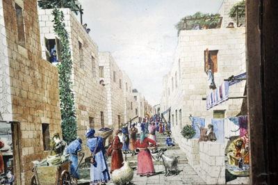
Wayne Stiles always writes enthusiastically about places in Israel that have a connection with the Bible. In his latest article for the Jerusalem Post, he describes the steps leading up to the Double Gate of the Temple Mount. These were indeed used by most of the pilgrims that used to go up to the Temple to worship.
Wayne recounts that some tourists say the 15 Psalms (120-134), called “Psalms of Ascents” (which could be translated the Psalms of the Steps) on the Southern Wall Steps.
There are, however, more than 15 steps, in fact, there are 27 at the eastern end and 31 at the southern end. Twelve of these steps are broad landings, which some people have suggested have a spiritual meaning (twelve being the number of Israel). However, as the lower steps are cut out of the bedrock, these landings were designed to take the natural slope into consideration, making the ascent easier as well. Wayne correctly observes that:
The Mishna notes that these fifteen psalms were sung by the priests who stood not on the Southern Steps, but on the fifteen steps from the Court of the Women ascending to the Court of Israel: “On the fifteen steps which led into the women’s court, corresponding with the fifteen songs of degrees, stood the Levites, with their musical instruments, and sang” (see m. Sukkah 5:4-5).
This moving scene has been portrayed in one of our models:
A downloadable pdf of an article by this name written by Israel Finkelstein, Ido Koch and Oded Lipschits is available at http://www.arts.ualberta.ca/JHS/Articles/article_159.pdf
Published in The Journal of Hebrew Scriptures, Volume 11, Article 12, it attempts to provide an answer to the problem that intensive archaeological research on the City of David ridge, conventionally regarded as the original mound of Jerusalem, has proven that:
“between the Middle Bronze Age and Roman times, this site was fully occupied only in two relatively short periods: in the Iron Age IIB-C (between ca. the mid-eighth century and 586 B.C.E.) and in the late Hellenistic period (starting in the second half of the second century B.C.E.). Occupation in other periods was partial and sparse—and concentrated mainly in the central sector of the ridge, near and above the Gihon spring. This presented scholars with a problem regarding periods for which there is either textual documentation or circumstantial evidence for significant occupation in Jerusalem; we refer mainly to the Late Bronze Age, the Iron IIA and the Persian and early Hellenistic periods.”
The solution they put forward is as follows:
“… we raise the possibility that similar to other hilly sites, the mound of Jerusalem was located on the summit of the ridge, in the center of the area that was boxed-in under the Herodian platform in the late first century B.C.E. Accordingly, in most periods until the second century B.C.E. the City of David ridge was outside the city. Remains representing the Late Bronze, Iron I, Iron IIA, and the Persian and early Hellenistic periods were found mainly in the central part of this ridge. They include scatters of sherds but seldom the remains of buildings, and hence seem to represent no more than (usually ephemeral) activity near the spring. In two periods—in the second half of the eighth century and in the second half of the second century B.C.E.—the settlement rapidly (and simultaneously) expanded from the mound on the Temple Mount to both the southeastern ridge (the City of David) and the southwestern hill (today’s Jewish and Armenian quarters).”
They acknowledge that their theory cannot be proven without archaeological excavations taking place on the mount, something we all know to be impossible and quote N. Naaman, who wrote that: “the area of Jerusalem’s public buildings is under the Temple Mount and cannot be examined, the most important area for investigation, and the one to which the biblical histories of David and Solomon mainly refer, remains terra incognita”, (1996. The Contribution of the Amarna Letters to the Debate on Jerusalem’s Political Position in the Tenth Century B.C.E. BASOR 304: 18-19).
Whilst we cannot deny this, I feel that it is overstates the case. I believe that there are enough clues on the surface and in the walls and underground structures of the Temple Mount to deduce much of the history of Jerusalem. And, with the publication of The Quest – Revealing the Temple Mount in Jerusalem, the mount is certainly less “incognita”!
It is true that the area between the Square Temple Mount and the Herodian Southern Wall is quite large and it is possible that some houses were built there in the “missing” periods. The problem, however, is that in 186 B.C. Antiochus IV Epiphanus built the Akra in this location. Some 25 years later, in 141 B.C., this fortress was totally destroyed by Simon Maccabee and the mountain leveled. So, even if one could excavate this area, nothing much would be found.
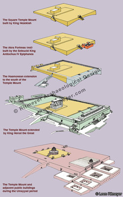
These five drawings show the five stages in the development of the Temple Mount in Jerusalem. From top to bottom: 1. The square Temple Mount built by King Hezekiah. 2. The Akra Fortress (red) was built by the Seleucid King Antiochus IV Epiphanes in 168 BC to control the local Jewish population. The fortress was destroyed by the Maccabees in 141 BC. 3. After the destruction of the Akra, the Hasmoneans extended the Temple Mount to the south (blue). 4. Herod the Great renewed the Temple Mount by enlarging the square Temple Mount to double its size and building a new Temple. 5. During the Umayyad period, the Dome of the Rock was built on the site of the Temple and the El Aqsa mosque on that of the Royal Stoa. Large public buildings were erected to the south and west of the Temple Mount
Additionally, as Todd Bolen also pointed out, the access from the proposed “mound” to the water supply would have been unprotected, which is both unsatisfactory and contradicts the Biblical account that the City of David was located near the Gihon Spring.