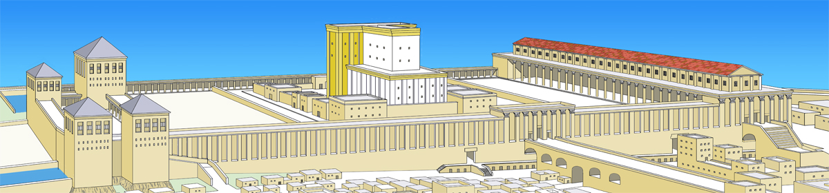
The Image Library of Ritmeyer Archaeological Design contains authoritative reconstruction drawings and models which you will not find on any other website. The photos of ancient sites in the lands of the Bible have also been taken through the informed lens of an archaeological architect. A treasure-trove for teachers, pastors, lecturers and picture editors, it is the result of years of experience digging and researching in Israel and traveling in the surrounding countries.
The Image Library is arranged in different categories and is fully searchable. The different categories are designed to help you find the picture you are looking for easily. All preview illustrations are watermarked, but these won’t appear on the downloads.
For ease of use, each image comes with a descriptive note and, where applicable, full Scripture references. With the explosion of information coming from excavations, we hope that this will become an ever-expanding resource vital for all who wish to incorporate both beauty and authenticity into their portrayal of the Bible background.
After talking about doing this for the past 10 years, we’ve finally done it! Let us know of any images you’d like to see added to the library…
In just a few days time, our Image Library (see introduction in previous post) should be online. Below are two samples to give a foretaste of its contents. All preview illustrations are watermarked, but these won’t appear on the downloads.
This drawing is a development of the plan of this religio-political complex which we supplied for the ESV Study Bible (p. 607). Here is the description that goes with the drawing of Solomon’s Temple-Palace complex in the Image Library:
According to 1 Kings 6 and 7, Solomon built a new Temple and Palace Complex on Mount Moriah. This schematic drawing shows an arrangement of the different buildings, based on parallels with similar complexes excavated elsewhere in the Middle East. The main entrance was through the Hall of Pillars (1 Kings 7.6), which was flanked by the Throne Hall (1 Kings 7.7) on the right, where Solomon judged, and the armoury, called the House of the Forest of Lebanon (1 Kings 7.2-5) on the left. In the centre of this complex is the palace, called Solomon’s House (1 Kings 7.8a), which had a separate wing for his wife, Pharaoh’s Daughter (1 Kings 7.8b). From a large courtyard in front of Solomon’s House, a special Royal Ascent (1 Kings 10.5 KJV) led up to the Temple (1 Kings 6), which lay on higher ground.
This drawing is annotated, but as with many of the other illustrations, a copy without annotations is also available for you to add your own.
2. Altar of Zeus at Pergamum
Located in modern-day Turkey, Pergamum (also known as Pergamon or Pergamos) was the third of the seven churches of Asia to receive a letter from Jesus Christ (Revelation 2.12-17).
The Altar of Zeus stood on a terrace on the west side of the hill of Pergamum. In the 19th century, German excavators recovered many scattered remains of this altar and reconstructed it in the Pergamum Museum in Berlin. The altar consisted of a monumental stairway leading up to a colonnaded court where an altar for burnt offerings was located. A frieze, depicting a mythological battle between Greek gods and giants, runs round the structure. Superimposing a picture of this altar model on the site shows what an impressive building it was. Some scholars have suggested that this monument, which was an important center of pagan religion, constituted the “Throne of Satan” (Revelation 2:13). However, as Christians were mainly persecuted because of their refusal to worship the emperor, this “Throne of Satan” appears rather to refer to the Roman seat of government which was also located in Pergamum.
I have been informed by Immersion Digital, the Florida based company that produces GLO Bible Software, that a Mac version will be published soon. As a dedicated Mac user, I very much look forward to using it. I have been promised a preview test copy and can’t wait to see it.
Todd Bolen of BiblePlaces.com made an interesting comment in response to my post on Rachel’s Tomb, which wouldn’t show up in the comments box. Todd has an excellent knowledge of the Land of Israel and his comments are always worth reading. Here is his comment:
Leen,
Thank you for your research on this challenging issue. Porter’s explanation is certainly a creative way of handling the problem. I’ve written up an explanation which is a bit more traditional in having support from numerous scholars in the last hundred years. I will post that later today at http://blog.bibleplaces.com. I want to suggest here a few potential weaknesses in this proposed solution:
The texts locate Migdal Eder in relation to Jerusalem, not to Bethlehem. As far as I can tell, in the Sheqalim text, Migdal Eder could be any direction from Jerusalem, not near Bethlehem as you write. Micah 4:8 clearly places it near Jerusalem, not Bethlehem. In that case, Rachel’s tomb cannot be at the traditional location, because Rachel was buried north of Migdal Eder.
There is no evidence that tribal borders moved. As you say, Kiriath-jearim was located on the Judah-Benjamin border. Jerusalem was also on the north side of the border. That the borders would have expanded significantly at Judah’s expense in the period *before Saul became king* seems unlikely given Benjamin’s weakness and major population decrease (Judg 20-21). In any case, the shift proposed here is 5 miles, an enormous alteration for which we would expect to see some other evidence. The only evidence for it is the location of Rachel’s tomb, and I think there’s a much easier solution to handle this piece of data.
The first map does not correctly reflect the border description of Benjamin which runs through the Hinnom Valley *north to Mei Nephtoah* and west to Kiriath-jearim. The Mei Nephtoah point is very inconvenient for Porter’s theory, but it should not be ignored.
Thanks again for this post and your insights. As always, I benefit from your wisdom and experience.
Todd explained his own position on the location of Rachel’s Tomb in his latest post.
As I mentioned in my post, certainty eludes us as to the location of Rachel’s Tomb, as there are too many unknowns. I only put up Porter’s ideas for curiosity’s sake, as I know the difficulty of the connection with Benjamin’s border in the account of Samuel.
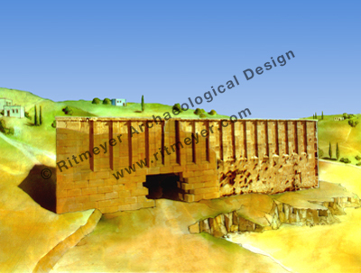
I remember visiting Qubur Bani Isra’il a long time ago, but didn’t know then what to make of these massive stone monuments, one of which has a small chamber built into it. My initial impression was of that of tank barriers, but I soon realised that they may be archaeological structures. Some visitors in the 19th century even called them megalithic monuments. They were apparently also known as Kabiir el Amalikeh, the Tombs of the Amalekites. It would be interesting to excavate them.
However, as you say in your post: “The best evidence for answering this question is the oldest evidence.” In this case, it is the record of Rachel’s delivery of Benjamin and her subsequent death and burial in Genesis 35, where Ephrath is mentioned twice (vs. 16 and 19) and connected with Bethlehem in vs.19. It is highly unlikely to say the least, that two place names, at the same time, both referred to the much lesser known sites of the same name, as you suggest, and not to the places which are of such major significance in the Bible record. Although Bethlehem is assigned firmly to Judah in passages such as Judges 17.8 and Ruth 1.2, one could not expect the same in the book of Genesis, before the tribal portions had been allocated.
So, despite the problems thrown up by poorly understood later passages, one would expect the tomb of Rachel to have been located close to the entrance to Bethlehem. Its exact location remains one of those unresolved questions of Biblical geography.
This is a question which used to be debated by scholars, but is now used by politicians to delegitimise the Jewish claim to Rachel’s Tomb, as reported in a previous post. The Palestinians are trying to deny that the disputed building near Bethlehem is Rachel’s Tomb, thereby denying their own traditions, up to 1996 that is to say, for political reasons. Israeli commentators on the right of the political spectrum insist on the historicity of Rachel’s Tomb, while others on the left don’t seem to care, doubting if Rachel ever existed.
I have no political axe to grind, but am interested in the geography of Biblical places, although the narrative is not always easy to understand. The Bible tells the story of Rachel’s giving birth to Benjamin and her subsequent death in Genesis 35. Jacob later sums it up in Genesis 48.7:
“When I came from Padan, Rachel died by me in the land of Canaan in the way, when yet there was but a little way to come unto Ephrath: and I buried her there in the way of Ephrath; the same is Bethlehem.”
Based on this text, it is clear that Rachel’s Tomb must be near Bethlehem and a little to the north of it, as Jacob came from that direction. This is further emphasised by Genesis 35.21: “And Israel journeyed, and spread his tent beyond the tower of Edar”. Migdal Eder in Hebrew means: The Tower of the Flock. This is picked up by the Prophet Micah 4.8,
“And thou, O tower of the flock, (Migdal Eder) the strong hold of the daughter of Zion, unto thee shall it come, even the first dominion; the kingdom shall come to the daughter of Jerusalem.”
According to Mishnah Shekalim 7.4, Migdal Eder was a place near Bethlehem where special flocks were kept from which lambs were taken for the Temple sacrifices on a daily basis. The next chapter in Micah states that the Messiah was going to be born in Bethlehem:
“But thou, Bethlehem Ephratah, though thou be little among the thousands of Judah, yet out of thee shall he come forth unto me that is to be ruler in Israel” (Mic. 5:2 ).
The connection between Bethlehem and Rachel remains strong in the story of the Massacre of the Innocents by King Herod, recorded only in the Gospel of Matthew (2.16). The evangelist sees the slaughter in Bethlehem as the fulfilment of Jeremiah’s prophecy: “In Rama was there a voice heard, lamentation, and weeping, and great mourning, Rachel weeping for her children, and would not be comforted, because they are not” ( 31.15).
Why did Jeremiah mention Rama in connection with the weeping of Rachel? In Jeremiah’s time, Rama was the place where the prisoners of Judah and Benjamin were gathered before they were carried away to Babylon (Jeremiah 40.1). Jeremiah was one of the prisoners, but was set free:
“Nebuzar-adan the captain of the guard had let him go from Ramah, when he had taken him being bound in chains among all that were carried away captive of Jerusalem and Judah, which were carried away captive unto Babylon.”
Rachel represents the Jewish nation in trouble, just as Rachel herself was when Benjamin was born. It does not mean that her tomb must be in Rama.
This last quote and the one in 1 Samuel 10.2, where Samuel tells Saul to go to Rachel’s sepulchre in the border of Benjamin at Zelzah, has prompted some scholars to locate Rachel’s Tomb to the north of Jerusalem. The location of Zelzah is unknown and the word does not appear as a place name anywhere else in Scripture. If it was a place name, it must have been on or near the border of Benjamin. The term ‘borders’ in the Bible is not to be understood as having fixed barriers as we have today. It denotes an area of influence that can shift over time. For example, Kiriath-jearim is located on the border of Benjamin and Judah. In the allocation of the Land to the tribes, Joshua 15.9,60 includes it in the portion given to Judah, while three chapters on, it is listed as one of the cities of Benjamin (Joshua 18.28). In this interesting fluctuation between Judah and Benjamin, Kiriath-jearim resembles Jerusalem, which is also variously described as belonging to one or the other tribe (Joshua 15.63; 18.28). At the time of Saul, the border may have shifted to the south and west of Jerusalem.
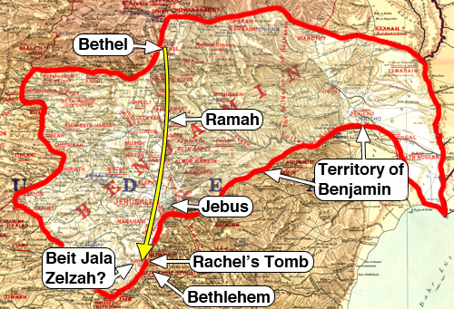
I came across a novel solution to the “border problem” and have tried to illustrate this (see map below). In my plan chest, I have a set of Palestine Exploration Fund maps published in 1880 with the tribal territories marked on. It also shows Rachel’s Tomb by its Arabic name of “Kubbet Rahil”. The map doesn’t agree with modern ones, but is interesting nevertheless. The territory of Benjamin is shown with the border west of Jerusalem (Jebus) further to the south. The mapping may have been influenced by the Irish missionary, Josias Leslie Porter, who wrote about Rachel’s Tomb in his “A Handbook for Travellers in Syria and Palestine,” (1858, p.74) “It is one of the few shrines which Muslems, Jews, and Christians agree in honouring, and concerning which their traditions are identical.” In referring to the nearby village of Beit Jala he asks, “Is this not the Zelzah mentioned by Samuel in sending Saul home after anointing him king in Ramah?” He then sketches out what for him must have been the southern border of Benjamin – “a crooked one it is true”. When he became president of Queen’s College in Belfast, he published “Jerusalem, Bethany and Bethlehem” (1886) in which his question about Zelzah was formulated as a statement!
I have used the PEF maps with the anachronistic territory of Benjamin marked out as a background to reconstruct the journey of Jacob and his family recorded in Genesis 35 (according to Porter).
The territory of the Tribe of Benjamin according to Porter. The yellow arrow indicates the journey from Bethel to the place where Rachel was buried. Porter includes territory to the southwest of Jebus and places Zelzah at Beit Jala. Samuel told Saul that he would meet two men at Rachel's sepulchre in the border of Benjamin at Zelzah. According to this map, the Tomb of Rachel should therefore be located between Beit Jala and Bethlehem.
If one could accept Porter’s sweeping statement that Beit Jala is Zelzah, it could work. Jacob travelled from Bethel in the north (vs. 16) over the main north-south road, passing by Ramah and continuing on the west side of Jerusalem (Jebus) and, after crossing what would later become the border between Benjamin and Judah at Zelzah, planned to travel to Bethlehem. It would place the location of the original Tomb of Rachel firmly in the territory of Judah in between Jerusalem and Bethlehem. But certainty eludes us …
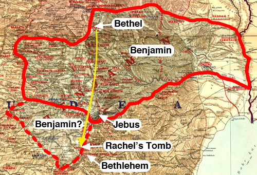
This map shows the generally accepted territory of Benjamin with Porter's addition shown in the broken red line. In this case, Zelzah could have been located where the yellow line crosses the red line, west of Jebus. Rachel's Tomb would have been located a little distance further to the south.
Unlike the Tomb of the Patriarchs at Hebron, see previous post, I could never make a reconstruction drawing of Rachel’s Tomb. It was marked originally merely by a pillar and its subsequent forms simply reflected the architectural style of whoever was ruling the country. No one knows exactly where Rachel was buried, but the Biblical pointers indicate that it must have been somewhere close to the site traditionally believed to be that of the Jewish matriarch.
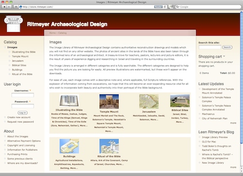
Good news for teachers, lecturers, picture editors and publishers! We are excited to announce our new Image Library which will go online in about a week’s time. There are already hundreds of reconstruction drawings and photographs of Biblical sites and models in our Image Library and we hope to add many more over time.
These images (unique to Ritmeyer Archaeological Design), are arranged in different categories, such as Illustrating the Bible, Temple Mount, Jerusalem, Biblical sites, Buildings and Ritual of the Bible. The Image Library will be fully searchable.
All the images come with a description giving full background information, which you can read before you decide which ones you would like to order. You can also view them in a reasonably large size before downloading.
Here is an sample of the “Illustrating the Bible” page, showing that you can browse according to Books in the Bible:
Another way of browsing, for example, is using the “Biblical Sites in Israel” page:
The different categories are designed to help you find the picture you are looking for easily.
Images can be downloaded individually to enhance your presentation. The pictures can be used privately or in presentations at Sunday Schools, Bible Classes and lectures at Universities.
Larger size images are available for commercial publication.
The new Carta Collection offers an outstanding collection of Bible Atlases and books on the historical geography of the Bible. Each book is richly illustrated with original artwork, reconstructions, drawings, and diagrams. These are must-have volumes for anyone interested in the background of the Bible, and for teachers at every level.
As a Mac user, Accordance is my favourite Bible Software and I use it almost on a daily basis. We were pleased to know that three of our books were chosen to be part of this selection:
The Quest, Revealing the Temple Mount in JerusalemJerusalem in the time of NehemiahJerusalem in the Year 30 A.D.
Todd Bolen of BiblePlaces.com wrote this about the collection:
An extraordinary collection of historical and geographical works on the Bible from the Carta Publishing House in Jerusalem has been announced for Accordance Bible Software (Mac). Some of these works are the best in the field and available nowhere else electronically.
The collection consists of the following books:
Bible Lands Atlases
The Sacred Bridge
Carta’s New Century Handbook and Atlas of the Bible
The Carta Bible Atlas
The Illustrated Bible Atlas with Historical Nots
Bible History Atlas Study Edition
The Onomasticon by Eusebius of Caesarea
Jerusalem
The Illustrated Atlas of Jerusalem
Carta’s Historical Atlas of Jerusalem
Jerusalem in the Time of Nehemiah
Jerusalem in the Year 30 A.D.
Temple
The Quest
Carta’s Illustrated Encyclopedia of The Holy Temple in Jerusalem
Here is a report concerning the recent dismissal by Israel’s High Court of Shurat HaDin’s private prosecution of the Islamic Waqf for the Waqf’s depredations on the Temple Mount:
Israel’s High Court of Justice has handed down a decision which blocks a
first-of-its-kind private prosecution brought by Shurat HaDin against the
Islamic Waqf (“Trust”) in Jerusalem.
The Waqf is the radical anti-Israel authority which the government allows to oversee Muslim holy places including the mosques on Jerusalem’s Temple Mount. Following months of reports that the Waqf was utilizing bulldozers on the Temple Mount to carry out unauthorized construction that was obliterating ancient Jewish artifacts and the refusal of the Israeli police to act to safeguard these relics, we decided to go to Court against the Muslims.
Israel National News (Arutz 7) has a similar report:
Attorneys from the Israel Law Center accused the Wakf of deliberately destroying Jewish artifacts in order to eradicate evidence of the Jewish claim to the Temple Mount. By neglecting to take action to stop the demolition of ancient historical finds, the Israel government has been “abandoning the millenniums-long Jewish claim over the Temple Mount and allowing Islamic extremists to re-write Jerusalem’s history,” they said.
The attorney general’s office had tried to get the Israel Law Center suit dismissed, arguing that private citizens should not be allowed to prosecute in a case that affects the general public. The Law Center responded by accusing the attorney general of caving in to political pressure.
In response to my previous post, Joe Zias, physical anthropologist, who worked for many years for the Israel Antiquities Authority, wrote concerning Rachel’s Tomb:
Check out photographs at Yad Ben Tsvi lib. to see Islamic graves surrounding the site up to and abutting the shrine. I in fact was called in to view burial remans just a few meters to the north of the entrance which lie under the pavement in which all and everyone walks across. they were Islamic according to their orientation and no more than a few hundred yrs old. Haredim were satisified that they were not Jewish and covered up the remains (so they said).
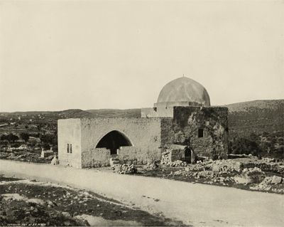
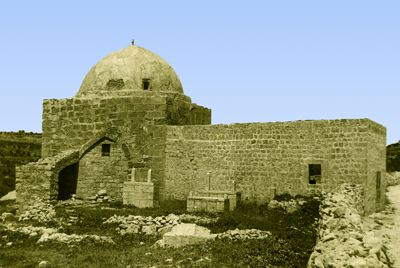
There certainly has been a Muslim graveyard next to Rachel’s Tomb for the last few hundred years. See pics below. However, a cluster of Muslim tombs does not a Muslim site make. The exterior of the eastern wall of the Temple Mount is lined with Muslim tombs, but we know a lot more about its history than that fact. Rachel’s Tomb is not just the tomb of an insignificant female character from the Bible, but of Rachel, who the Jews call Imeinu, “Our mother”, wife of Jacob, the third Jewish patriarch. The site of her tomb is noted twice in Scripture: Gen. 35.16-20 and 1 Sam. 10.2 and by numerous early pilgrims to the Holy Land.
Rachel's Tomb in 1894 - note Muslim graves around the building
The Muslims, who walked into history more than 2,500 years later, also revere Rachel and her name appears in the Koran. It is because of that association that her tomb became a popular “wely” or site to hold funerals.
Rachel's Tomb in the 1930's - note the Muslim tombs next to the building
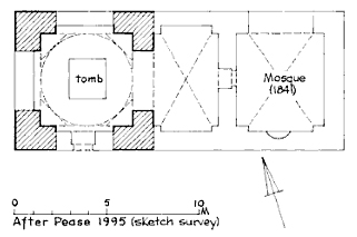
And when Moses Montefiore bought the site for the Jews in 1841, he built a vaulted vestibule for the Muslims to pray in, in order to conciliate them. Denys Pringle in his comprehensive historical note to the site in The Churches of the Crusader Kingdom of Jerusalem, (written in 1995, with no political axe to grind) provides a sketch plan of how this building relates to the tomb.
Rachel's Tomb, plan made in 1995
It is difficult to see how this Muslim reverence for Rachel translates into the recent renaming of the structure, the Bilal bin Rabah Mosque, after an Ethiopian Muslim believed to be the first muezzin! This rewriting of history is heading up for one more battle in the conflict over the Holy Places. It reminds me of the statement of a Muslim tour guide who we once employed to show us round the Temple Mount, in order to get their perspective. He told us, in all seriousness: “Melchizedek was the first Palestinian king of Jerusalem!
The politicians are at it again. UNESCO has declared The Tomb of Rachel to be a mosque. Israel’s Prime Minister has slammed the report.
The claim is, of course, ludricous. This photograph, taken in 1890-1900, already describes the building as The Tomb of Rachel:
The Tomb of Rachel - photograph taken in 1890-1900
Joe Lauer reminded us of what Abba Eban once said about the United Nations General Assembly, “If Algeria introduced a resolution declaring that the earth was flat and that Israel had flattened it, it would pass by a vote of 164 to 13 with 26 abstentions.”
When guiding round the Temple Mount excavations, we always pointed out that the headquarters of the United Nations are rightfully situated on the Mount of Evil Counsel.
In another report, the US demands from Israel to remove the Tomb of the Patriarchs from Israel’s list of national heritage sites. The very architecture of the Tomb of the Patriarchs of proves that it was built by Herod the Great.
The Mugrabi Gate is also in the news, as it has been reported that falling stones from the ramp could endanger the women who pray below:
UNESCO appeared to support the PA demand for the Temple Mount as well, asking that Muslim officials be allowed to examine the Mughrabi Gate near the Western Wall (Kotel). Muslim leaders have accused Israel of attempting to damage the Al-Aksa Mosque on the Temple Mount under the guise of repairs to the Mugrabi Gate. Israeli officials have warned that if the gate is not repaired, it could collapse, putting worshipers at the Western Wall at risk.
Rabbi Shmuel Rabinovich, Rabbi of the Western Wall, termed the decision “outrageous.” “They have never said in the past that this was a Muslim holy site. The [UN] organization responsible for heritage has turned heritage into politics.” Israel should think carefully about whether or not to cooperate with UNESCO in the future, he said.