Israel Government buries Temple Mount report

The Jerusalem Post has a follow-up on Sunday’s article on the Temple Mount report, as reported in our previous post:

Comptroller Temple Mount report stays behind closed doors

It reminded me of a volunteer who found a camel’s tooth on the Temple Mount dig. She was so excited that she buried it again for another volunteer to find and be excited as well. The Knesset is burying part of this highly sensitive document “for diplomatic and security reasons”.

Israel is a democracy, so this report will eventually be unearthed again and I wonder if the public will be so excited as the second volunteer, when they read it, for “It is not a secret that the Waqf is building on the Temple Mount, that works have been done, and that many archeological findings have been destroyed.”

Source: Joe Lauer

Jerusalem and the Turks

It is a well-known fact that most British people are unaware that they no longer control an empire. Perhaps they can be excused because, although most colonies separated from Britain after the Second World War, the last colony of Hong Kong was lost only 13 years ago.

The Turks seem to suffer from a similar delusion. The Turkish Empire came to an end officially in 1923, but in practical terms, towards the end of the First World War. However, the Turks apparently still believe that Jerusalem belongs to Turkey. Why otherwise, according to this and this report, would they be building a 10 m. high wall around the Muslim Cemetery next to the Lions Gate?

The cemetery next to the Lions Gate

A couple of years ago the TIKA (Turkish International Cooperation and Development Agency) opened an office for the Committee for the Protection of Muslim Cemeteries in Jerusalem. This office is responsible for the maintenance of Turkish cemeteries in Jerusalem.

When Israel builds a 10m. high wall to keep suicide bombers out, the world is up in arms, but when the Turks build a 10 m. high wall in Jerusalem, nobody seems to care. What is the purpose of this wall – to keep suicide bombers out or the ghosts in?

Source: Joe Lauer

Report on the Destruction of the Temple Mount

Government ‘tried to bury’ report on Temple Mount excavations

This funny pun introduces an article about the suppression by the Government of Israel of a report on the illegal Temple Mount excavations.

We had earlier reported here, here, here, here, here and here on these illegal excavations and registered our protest.

The newspaper article goes on to say:

The report has not yet been published but Knesset sources who have seen it say it contents are so sensitive that they could spark riots once revealed.

It doesn’t take much to spark a riot in Jerusalem, but we are interested to hear more about this report than seeing people injured.

First Temple period wall found in Jerusalem – revisited

One of my blog readers, Arthur Chrysler, made the following comments on a previous post, which I would like to share with other blog readers:

The Large Tower, explored by Warren and one hundred years later by Dame Kenyon, is constructed of stones of the character identified as Phoenician at Samaria. The header-and-stretcher construction is also identified as Phoenician at Samaria. Kenyon stated, “The date of these earliest walls, on the basis of the deposits against them, is, on the field estimate of the pottery, eighth century B.C. OR EARLIER (Digging up Jerusalem p.115). She also states in the caption under pl. 38, “Wall in Site S II on eastern crest of eastern ridge, which can be STRATIGRAPHICALLY dated to 8th century B.C….”. This area of Jerusalem is not a Tel! You cannot stratigraphically date anything here. This unique topography, consisting of a steep slope with exposed bedrock demands unique methodology. Kenyon states that, “Close at hand, there was a wall of the time of Solomon, from which the builders of the eighth century B.C. derived their stones”. King Hezekiah had a unique style of construction as seen in the Broad Wall, the Outer Wall, and his section of wall cutting across the Jebusite angle above the Gihon Spring. None of these examples give a hint of header-and-stretcher characteristics. Why would Hezekiah go through the trouble of re-stacking Solomon’s massive stones to move the tower only a few meters? Kenyon used the dating method that she was familiar with but it led her to the wrong conclusion regarding the tower here. The tower is certainly Solomonic and the connected wall and the Golden Gate, all of which display Identical characteristics.

If it is true that nothing can be dated stratigraphically in this part of Jerusalem, how can you then insist on a Solomonic date for the wall in Kenyon’s site SII and Benjamin Mazar’s Field 23? Kathleen Kenyon excavated down to the bedrock in this area and indeed concluded that:

“Beneath … the Byzantine wall … is a wall which probably belonged to a projecting tower. The date of these earliest walls, on the basis of the deposits against them, is … eighth century B.C. or earlier.” “… these walls were constructed of re-used stones … with irregular projecting bosses having margins on one, two or three sides.”

If these stones are indeed in secondary use, which I am not convinced of, it is possible that these are rejects or surplus masonry from Hezekiah’s square Temple Mount construction.

If you would examine the elevation, section and Isometric drawing of the Ophel Wall on Warren’s Plans, Elevations, Sections, etc., (1884), Plate 40, then it is clear that this L-shaped wall is built against an earlier wall and one can still see today that two different First Temple period building phases are represented in this area. That is why Warren called this wall section the “Extra Tower” or “Corner Turret”, i.e. it is a tower that was later added to strengthen an earlier fortification or part of the city wall. If the L-shaped wall, as you insist, is Solomonic, does that make the wall against which it is built Canaanite? If there are two construction phases in a building, that is called stratigraphy, showing that one wall is earlier than another. This stratigraphy is not different from that on a tell. This picture shows that the stratigraphically four building constructions can be identified:

1. The Byzantine Tower
2. Excavating inside and below the Byz. tower, a Herodian mikveh was found that was built against the inside wall of the “Extra Tower” (not visible in the picture)
3. The 8th century L-shaped “Extra Tower”
4. The pre-8th century wall against which the “Extra Tower” was built, which may be Solomonic if that can be proved conclusively.

Kenyon dated this L-shaped corner construction to the eighth century B.C. or earlier, but that does not necessarily mean that it is Solomonic. You compared it with the Phoenician masonry in Samaria, but that dates to the 9th century and is not Solomonic. A similar style masonry has been found in the sanctuary walls in Tel Dan, which is also post-Solomonic. I had suggested that there is an historical link between the “Extra Tower” and the masonry near the Golden Gate, but neither of these two constructions can be Solomonic.

Has King Herod lost his claim to the Hippicus Tower?

Joe Lauer alerted me to two recent reports, one that announces that “King Herod has lost his claim to being the original contractor of certain ancient structures in the area” and another that reports about “Revelations of an ever-changing past”.

From these reports I understand that archaeologists found an underground wall and intersecting aqueduct, both built by the Roman 10th Legion a little east of the Jaffa Gate, and drew the conclusion that the Tower of David was not the Hippicus Tower built by Herod the Great:

“The archaeologists’ discoveries had major implications. For one thing, they determined that the current Tower of David was not an extension of Hippicus, but rather of the Phasael tower.”

According to Josephus, these towers were built in the First Wall and not in the Second Wall. They stood at the northwest corner of Jerusalem and protected the city and Herod’s Palace that was built to the immediate south. Hillel Geva has shown conclusively that the Herodian Tower in the Citadel Museum is the Hippicus Tower.

“You have to understand that a 150-year mistake has finally been corrected,” explains Sion, referring to the Hippicus hypothesis. Second, it seems that countless maps and drawings of the so-called second wall suddenly became irrelevant.”

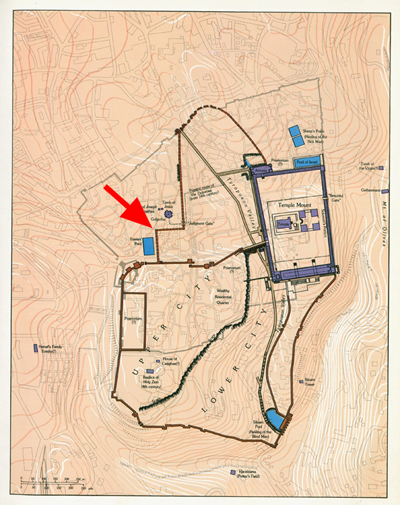
The Second Wall, according to Josephus, began at the Gennath Gate, which had been excavated by Avigad some 400 meters to the east of the Jaffa Gate, and ended at the Antonia Fortress at the northwest corner of the Temple Mount. Some maps still show the Second Wall going north from somewhere near the Citadel (David’s Tower) and then turning east to keep Golgotha outside the city and then going north again in the direction of the Damascus Gate. It will be good to get this “kink” out of the line of the Second Wall, but I am not too optimistic about this as it takes a long time for publishers to catch up with the latest archaeological discoveries. This plan of Jerusalem published in Dan Bahat’s Atlas of Jerusalem still has the kink in it (see red arrow):

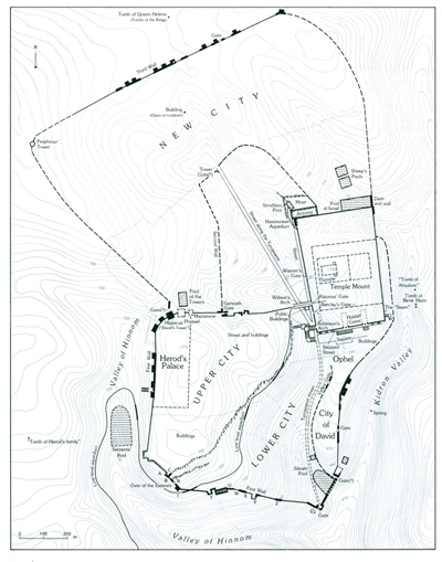
The “conceptual revolution about life in the city at the end of the Second Temple and Roman period (63 B.C.E.-324 C.E.)”, which the excavators claim to have made suddenly, however, had already been made by Avigad in the 1980’s, when he discovered the Gennath Gate and the beginning of the Second Wall in the area of the Cardo in the Jewish Quarter. The maps I have drawn for him and all subsequent maps of Jerusalem always showed that the Second Wall began at the Gennath Gate, which is located halfway between the presentday Jaffa Gate and the Temple Mount. The Second wall has been shown correctly, for example, in the New Encyclopedia of Archaeological Excavations in the Holy Land (1993):

I don’t quite understand their claim about the Hippicus Tower, which is a solid tower built on the bedrock. The masonry is Herodian and the 10th Legion’s aqueduct and wall in question does not come near the base of this tower. The fact that they acknowledge that an Herodian aqueduct may be located below the Roman aqueduct they found, proves that their claim about the Hippicus Tower still needs to be substantiated.

The Destruction of the Temple Mount continues

It is feared that the destruction of the Temple Mount by Muslims continues. It has been observed that work is taking place to the east of the Dome of the Rock, where the Court of the Priests and the Altar were located. According to this report:

“The Waqf works are constant, we see tractors going to and fro carrying earth. The work is taking place near the Dome of the Rock, exactly in the place between where our Holy Temple’s courtyard and the Altar used to stand. The Waqf claims they are doing pavement work there, or so they advertise in the news sites, but in practice they surrounded themselves in white burlap and we see there is scaffolding. I suppose that for paving works there should be no need for scaffolding.”

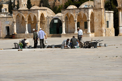
The bedrock is only a few feet below the pavement and the layers between it and the pavement could easily be destroyed. On a visit to the Temple Mount last year, we observed repairs to pavement north of the Dome of the Rock and it was clear that no digging with tractors was involved:

Hopefully some more information will become available soon.

Bible Lands Expedition (BLE) tour


Another BLE Bible Lands Expedition study tour is planned for October 2010, God willing. Dr. Steve Collins and myself will be leading the tour. This is an exciting adventure travelling through Jordan and Israel with the likely outcome that you’ll never read your Bible in the same way again! We do not take more than one bus full, so you really get to know each other well. There are a few places left, so have a look at the website and tour overview!

Protest over Western Wall Museum

Archaeologists are up in arms against the planning of a new Museum at the western side of the plaza area. See this report in Haaretz.
Some, like Yoram Tsafrir, are dead against it, while others, such as Uzi Dahari and Guy Stiebel are in favour.
Yoram’s comments sound a little dramatic:

The construction will cause generations of weeping over the serious damage to the site, Tsafrir said at the conference on archaeological findings in the Jerusalem area sponsored by the Hebrew University’s Institute of Archaeology and the Antiquities Authority.

As we have seen with the reconstruction and integration of the Byzantine Cardo in the Jewish Quarter, it is possible for preserved remains to be incorporated into modern buildings.

Source: Joe Lauer

ESV Bible Atlas by Crossway

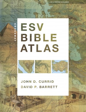
A few months ago, we received a pre-press copy of the ESV Bible Atlas to review:

Already then, we were very impressed with this atlas and wrote the following endorsement:

“I had the privilege of being involved in the production of drawings based on the latest research for the ESV Study Bible. It is a joy to see these drawings plus the original ESV Study Bible maps, woven together with numerous new maps, brilliantly evocative photographs and useful indexes to make up the new Crossway Bible Atlas. This volume will become an indispensable companion for Bible students, fulfilling every expectation you might have of such a tool. Particularly innovative is the use of terrain imagery to facilitate the reader’s understanding of such Biblical viewpoints as that of Abraham from Hebron over the cities of the plain or Moses from Mt. Nebo.”

Justin Taylor, who was the managing editor of the ESV Study Bible, wrote this in his blog:

“One of the neat things for me is being able to see the ESVSB illustrations—of the tabernacle, the temples, Jerusalem at various times, etc—in great detail over a two-page spread on glossy paper.”

We agree that on this glossy paper, the reconstruction drawings look even better than in the Study Bible. We are further told that

The new Crossway ESV Bible Atlas (352 pages) will be shipping soon from Amazon.

The text of the Atlas was written by Professor John Currid (RTS-Charlotte, NC). The maps were done by David Barrett, who also served as the cartographer for the ESV Study Bible. Here’s what it contains:

175 full-color maps
70 full-color photographs
3-D re-creations of biblical objects and sites
indexes
timelines
65,000 words of narrative description.
“The atlas uniquely features regional maps detailing biblically significant areas such as Egypt, Mesopotamia, Italy, and Greece. It also includes a CD with searchable indexes and digital maps, and a removable, 16.5 x 22-inch map of Palestine.”

You can flip through some of its pages here

As he lives in the USA, Todd Bolen received his copy yesterday, we can’t wait to receive ours in the UK soon as well.

Visit to Turkey

Apologies for my failure to blog in recent months. A research visit to Turkey and its subsequent recording, together with protracted happy family celebrations, account for this. Hope to make the results of our research available for educational use in the near future. In the meantime, however, must just mention the uncanny experience of finding myself in a site which I had drawn up from a distance some 15 years ago.

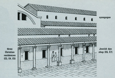
In 1996, Hershel Shanks, Editor of Biblical Archaeology Review, asked me to illustrate an article by John S. Crawford, entitled “Multiculturalism at Sardis” (BAR, Sept/Oct 1996 pp. 38 – 47). This involved drawing up a complex dating from the Byzantine period, which had been excavated in the city (originally mentioned as one of the 7 churches of Revelation). The complex comprised a colonnade of shops, some owned by Jews and some by Christians, an adjacent synagogue and adjoining this, an elaborate bath-gymnasium, with a marble forecourt:

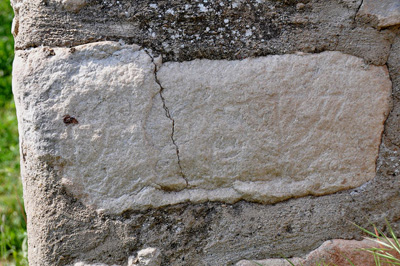
He also requested a detailed drawing of the shops, where symbols carved on the stones revealed the differing religious affiliation of the owners. The whole point of the article, was, as its title implies, to show how Christians and Jews lived in Sardis side by side, in full tolerance of each other. I distinctly remembered drawing the two menorot incised on the doorjamb of the shop identified as belonging to Jacob the dyer. On the drawing, the two menorot are drawn on the outside of the shop, although in reality they are carved on a stone of the inside door jamb:

On our recent visit to the site, however, there was no indication of these evocative symbols, only numbers labelling each shop. Knowing that they must be there, we peered and felt around and it was deeply satisfying to find one and then another lampstand carved into the stone, just as I had drawn them up from original photos, taken by the Harvard-Cornell excavations in the 1960s and 70s. A large menorah can be seen on the right side of the stone, while a smaller one is visible to the left of the same stone:

We were blown away by the richness of Turkey’s Biblical heritage and are astounded at the recent direction taken by the country. Whither the “Other Holy Land?”