Many tourists visit Bethlehem, specially at this time of the year (except in 2020 because of the pandemic), as that is where Jesus was born (Luke 2:11). We first learn about Bethlehem in the Book of Ruth, where we read that Boaz purchased Ruth the Moabitess according to the law of the levirate marriage, who then became his wife (Ruth 4:10). They had a son called Obed, who became the grandfather of David. Jesus is, of course, the greater son of King David. What do we know about his birthplace?
Both Mary and Joseph were descendants of King David. When the Roman government ordered a census to be carried out, they had to travel from Nazareth to Joseph’s ancestral home in Bethlehem, because he was of the house and lineage of David. Mary was descended from David through Solomon (Matth 1:16) and Joseph through another son of David, namely Nathan (Luke 3:31). We suggest that the place where Jesus was born was not a randomly chosen cave, but a place that was prepared centuries earlier for this purpose.
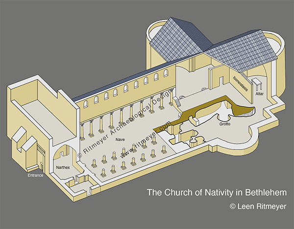
A reconstruction drawing of the Church of the Nativity in Bethlehem. This church is a basilica type building with a central nave and two double aisles. At the back of the church is a stairway that descends to a series rock-cut caves, one of which is the traditional Grotto of the Nativity.
Most people believe that the grotto in the Church of the Nativity in Bethlehem is the place where Jesus was born. In the early Byzantine period, a church was erected over this grotto by Constantine. After this building was destroyed in 529 CE, Justinian built a new church. In the floor of the Grotto of the Nativity is a silver star that indicates the traditional birth place of Jesus. It is important to remember, that after Jesus was born, he was laid in a manger (Luke 2:7). Mangers are found in stable blocks and not in caves or grottoes. The grotto in Bethlehem was originally a Roman shrine above which stood a temple to Adonis, the lover of Aphrodite.
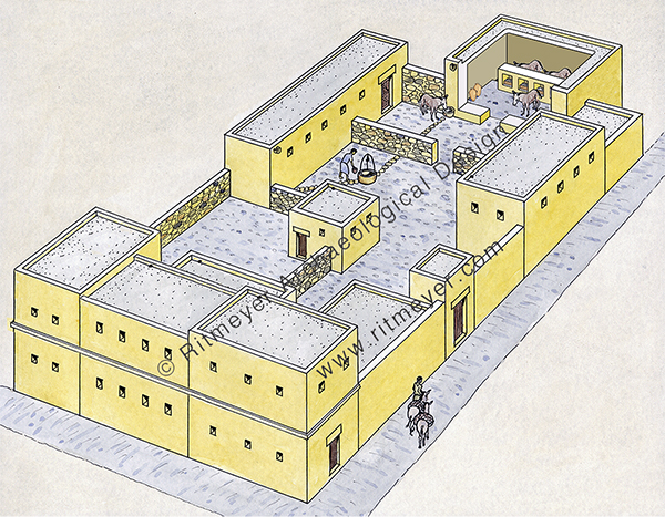
What do we know about the ancestral home of the family of David? Near the end of King David’s life, he had to flee from his son Absalom. He stayed with Barzillai, the Gileadite, whose son Chimham returned with David to Jerusalem (2 Sam 19:37-40). In order to provide Chimham with a source of income, David apparently gave him a part of his own inheritance in Bethlehem on which to build a house, which is later mentioned in Jer. 41:17, as the habitation of Chimham.
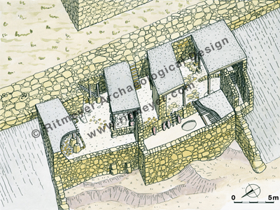
This drawing shows what a large house, such as the “habitation of Chimham” near Bethlehem, mentioned in Jer. 41:17, may have looked like in the first century. Rooms were arranged around the central courtyard, which had a well for drawing water. One, or perhaps more of the upper rooms, seen in the foreground, were reserved for important guests, while servants would have stayed on ground level.
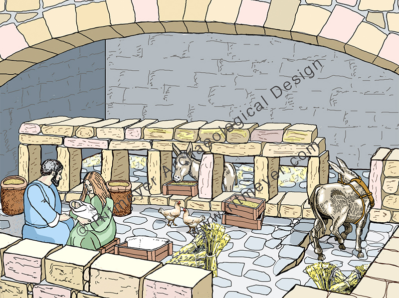
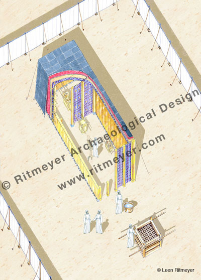
Joseph would naturally have gone to this home where this family members lived. In the Gospel record (Luke 2:7), we read that there was no room for Mary and Joseph in the inn. The for word “inn” is kataluma in Greek, and means an upper room or guest room. When Joseph and Mary arrived at their ancestral home, they were told that all the upper rooms were occupied and the only available space left for Jesus to be born was the stable block. Joseph and Mary had to share this stable with animals. It wasn’t a romantic Christmas postcard stable with smiling camels and donkeys, probably drawn by artists who don’t know how bad camels can smell and how loud the braying of donkeys can be!
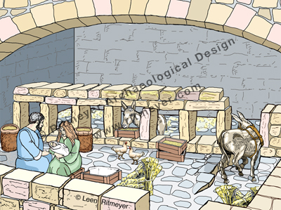
What actually did a stable look like in the time of Christ? From archaeology we know that stables looked like large rooms with a fenestrated wall, i.e. a wall with several low windows, built in the middle of the room. Animals were placed behind this wall and fodder was put in wooden boxes or baskets, called mangers, and placed in these windows. Sacks of provender were stored in the first half of the room. It was probably in this part of the stable that Mary and Joseph were allowed to stay and where Jesus was born and eventually placed in one of the wooden provender boxes, which would have served as his crib.
This drawing shows a typical stable block. The animals were kept behind the fenestrated wall (a wall with windows), while animal fodder and other provender was kept on this side of the wall. Fodder was put in mangers, or wooden feeding troughs, which were placed in the windows, so that animals could eat. Mary and Joseph (pictured here) would have put baby Jesus to sleep in such a manger.
If that is so, then one can only marvel at God’s providence that a birthplace was prepared by David, so that Jesus could be born in his own inheritance a thousand years later.
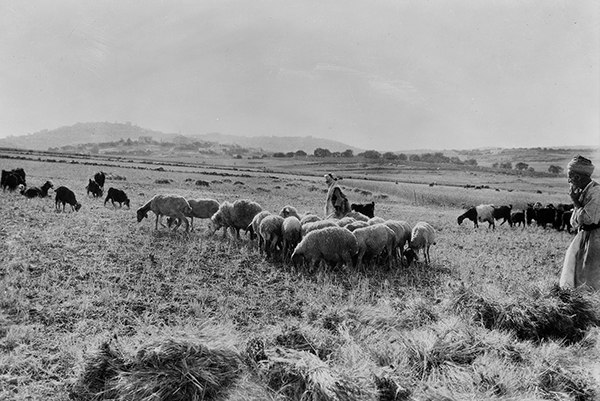
When Jesus was born, shepherds came to pay their respect, in fulfilment of Micha 4:8 that the former dominion will be restored to “the watchtower of the flock” (Migdal Eder in Hebrew). This Migdal Eder is the place where Rachel was buried (Gen. 35:21). At the time when Jesus was born, Migdal Eder was the place where special shepherds kept the flock from which the sacrificial animals for the daily sacrifice in the Jerusalem Temple were chosen. Angels from heaven announced to these special shepherds the good tidings of the Kingdom of God.
Here we see two shepherds with their flocks of sheep and goats in the Shepherds’ Field near Bethlehem. It was to shepherds like these thatangels from heaven announced the good tidings of the Kingdom of God. (Photo: Library of Congress, Matson Collection)
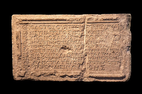
Apart from the first century Synagogue of Capernaum, the only other known synagogues from this period were found at Masada, Herodium, Gamla and Magdala. In Jerusalem, the Theodotus Synagogue inscription, dating from the same time, was found, but no remains of the actual synagogue have been found.
The inscription reads: “Theodotos son of Vettenus, priest and head of the synagogue (archisynagōgos), son of a head of the synagogue, and grandson of a head of the synagogue, built the synagogue (synagogē) for the reading of the law [nómou] and for the teaching of the commandments [didachín entolón], as well as the guest room, the chambers, and the water fittings as an inn for those in need from abroad, the synagogue which his fathers founded with the elders and Simonides.” (Wikipedia, photo: Andrey Zeigarnik)
We know that the Synagogue of Capernaum served as a place for the reading of the Torah and its study. But, what did the interior of the Capernaum Synagogue look like and how did the synagogue operate? In Luke 4:16-22 we read that in the synagogue of Nazareth, Jesus first stood up to read, and then sat down to teach. The question is, where did the reader stand and where did the teacher sit?
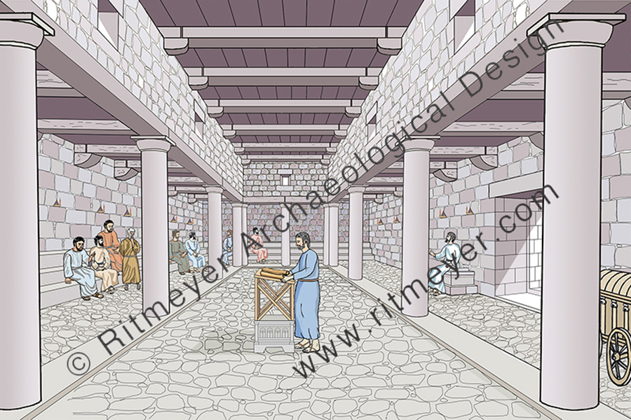
The 1st century Synagogue of Capernaum where Jesus preached. In the foreground we see the ruler of the synagogue bringing the Torah Scrolls in a chest on wheels, called the Ark of the Covenant.
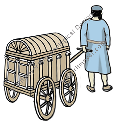
In a previous post, we have seen that in Capernaum the Torah Scrolls were transported in a wheeled carriage from the home of the ruler of the synagogue (archisynagogas) to the synagogue. These scrolls were apparently kept in the home of the ruler of the synagogue for security reasons.
The Torah Scrolls were transported in a wheeled carriage from the home of the ruler of the synagogue to the synagogue in Capernaum. The carriage has a panelled double door, Ionic pillars on the side as in a Greek temple and a convex roof.
The Law of Moses was first read, and then expounded on from Moses’ Seat, for in Acts 15:21, it says “For Moses has had throughout many generations those who preach him in every city, being read in the synagogues every Sabbath”. And in Matt. 23:2,3 Jesus said, “The scribes and the Pharisees sit in Moses’ seat. Therefore whatever they tell you to observe, that observe and do, but do not do according to their works; for they say, and do not do”.
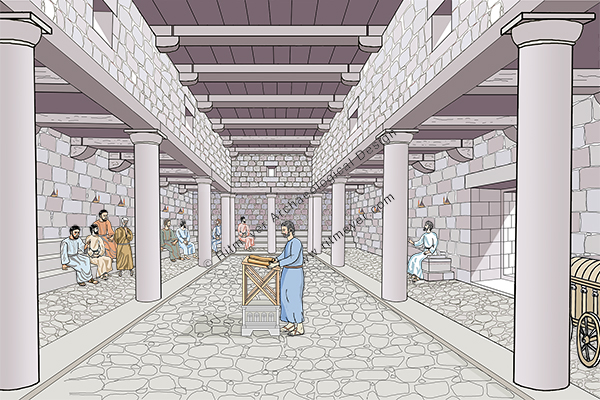
We have tried to put this information in a new reconstruction drawing of the interior of the Capernaum Synagogue. Opposite the entrance in the east wall, we see people sitting on stone benches, placed along three sides of the room.
In the centre of the hall is a reading platform, consisting of a decorated square stone on which a wooden lectern stands. This reconstruction is based on a similar stone that was found in the nearby synagogue of Magdala.
The reader read from the scroll that was brought into the synagogue in the wheeled carriage, which was placed at the left side of the entrance. The ruler of the synagogue took the relevant scroll out of the carriage and placed it on the lectern. On the right side of the entrance is a stone seat, called Moses’ Seat, where the teacher sat. Such seats have been found in the synagogues of Chorazin and Tiberias.
Jewish worship consisted initially mainly of prayers and the reading of the Law. This worship later developed into a full-blown service. The order of the services in the synagogue was as follows: (1) Reciting the Shema (Deut. 6:4-9; 11:13-21; Num. 15:37-41) (2) Prayer (3) Reading the law (4) Reading the prophets (5) Discourse by anyone who desired to speak (Acts 13:15) (6) the Benediction.
The order of the traditional Christian service is based on this Jewish one.
Apart from teaching in the synagogue, Jesus also performed miracles there, such as the healing of the man was there whose right hand was withered (Luke 6:6 – 10, Matthew 12:9 – 13, Mark 3:1 – 5), the man with an unclean (demonic) spirit (Mark 1:21-25), and perhaps also the woman who had a spirit of infirmity eighteen years, and was bent over and could in no way raise herself up (Luke 13:11-14). Jesus did these signs, not only to prove that he was the promised Messiah, but also to show the deeper significance of the Sabbath day as an example of the promised Sabbath rest for the people of God (Heb. 4:8-10).
At present, renewed excavations are being carried out under leadership of Dr. Scott Stripling, on behalf of the Associates for Biblical Research (ABR). He said that he answered the call of the prophet Jeremiah, who wrote: “Go now to my place that was in Shiloh … and see! (Jeremiah 7:12) – and so he did! What do we know about Shiloh and what did he and his team find?
Shiloh seen from the north. Drone picture by Gregor Brandson. Used by permission.
Certain places have a soul-stirring quality about them and on visiting them, you feel you are walking through shades of history in company with those who walked before you. Shiloh is one such place. To go back in time to this site that was so significant in the early history of Israel and in the lives of biblical characters such as Hannah and Samuel, is an exciting experience. No other biblical site has a geographical location so accurately described as that of Shiloh. According to Judges 21:19:
“Shiloh, is north of Bethel, on the east ofthe highway that goes up from Bethel to Shechem, and south of Lebonah.”
These directions could be followed today on a GPS or road atlas. Using this description, the American philologistE. Robinson, was able to identify Shiloh with Khirbet Seilun (Tel Shiloh) as early as in 1838, as it matches this geographical description exactly. Ancient sources such as Eusebius and Jerome confirm the accuracy of the identification. Today, this road on which Shiloh is located, is called Highway 60. It is nowadays also called the “Route of the Patriarchs”, as it follows the path of the ancient road that ran along the Central Mountain Range from Hebron to Shechem, that features often in the travels of the biblical patriarchs.
Shiloh in 1967. Photo: Leen RitmeyerShiloh in 2019. Photo: Leen Ritmeyer
During the wars waged by the Israelites against the Canaanites in the heartland of the country, the Tabernacle and the Ark stayed in Gilgal. Then, we read in the Book of Joshua: “the whole congregation of the children of Israel assembled together at Shiloh and set up the Tabernacle of meeting there.” (Joshua 18:1)
The Tabernacle was surrounded by an open court, formed by 60 pillars with silver capitals and linen curtains in between (Exodus 27). The Tabernacle itself stood at the back of this court with the Laver and the Altar of Burnt Sacrifices in front of it. In this drawing, we see the inside of the Tabernacle. Inside the Holy Place was the Lampstand (menorah), the Table of Shewbread and the Altar of Incense. The Ark of the Covenant stood in the Holy of Holies.
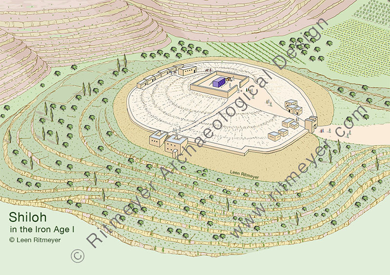
In contrast to many of the sites we have encountered, the site of Shiloh is almost devoid of notable features. All that remains is a small tell of not more than eight acres, secluded at the end of a fertile and quiet valley in the heart of the hill country of Ephraim, (although a thriving Jewish settlement has taken root adjacent to the tell). It was most probably the very seclusion of this site that determined its choice as the new site of the Tabernacle. Here the allotment of territory to the various tribes could proceed unhampered by interference of the Canaanites who still held large areas in their possession further to the north, south and west.
Leen and Kathleen standing next to a screen with Hannah’s Prayer in Hebrew and English.
Shiloh later became the permanent seat of the priesthood. The story of Hannah and Samuel in the first chapters of the Book of Samuel takes place against the background of Eli as High Priest. From these chapters, we get the impression that the Tabernacle was kept in some sort of permanent structure referred to as the “house of the LORD” (Hebrew – beth Yahweh) (1 Sam. 1:7,24 etc.), in contrast to the movable structure which was continually erected and dismantled during the wilderness wanderings. The Mishnah says as much:
“After they came to Shiloh, the high places were forbidden. There was no roof-beam there, but below was a house of stone and above were hangings and this was the ‘resting place’ “ (Zebachim 14.6).
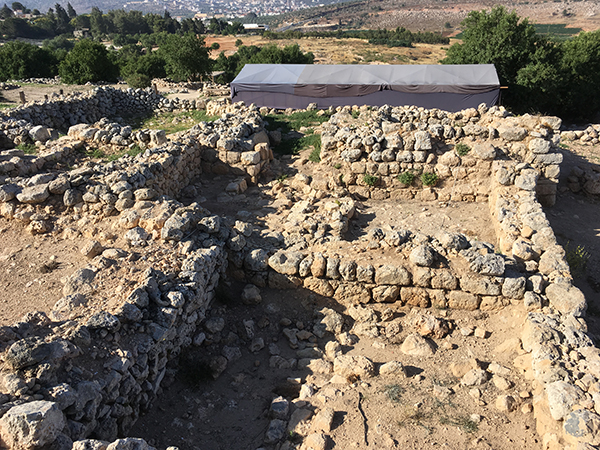
Tell Shiloh was first excavated by two Danish expeditions in the 1920’s and 30’s. Their excavations determined that the site was surrounded by a city wall in the Middle Bronze Age period, and had been destroyed by the Philistines in the mid-eleventh century BC. An Israeli expedition team led by Israel Finkelstein’s team in the 1980’s, made interesting findings on the west of the tell in their so-called Area C. Here they found, as shown in my reconstruction drawing, two Iron Age or Early Israelite buildings built against the outside of the Middle Bronze Age city wall.
During the excavations in Shiloh, an Early Israelite house was excavated near the city wall. Evidence shows destruction by fire. The ritual nature of the objects found in the debris above the destruction level suggested a connection with a cultic complex, perhaps that of the Tabernacle that stood here during the time of the Judges.
These pillared buildings contained an abundance of early Israelite pottery with over twenty of the collar-rim jars (although of a different collar-rim type than the Bronze Age ones) that characterize Israelite settlement in this part of the Land. Evidence that the buildings of this period had been destroyed by fire, confirmed the conclusions of the Danish teams. Because of the ritual nature of the objects found in the debris above the destruction level of these buildings, it was suggested that they stood fairly close to a large structure of a cultic nature on the summit. Can we deduce from this that the Tabernacle stood on the summit?
On the summit of the hill, south of the circular visitors centre, is a flat area the size of the Tabernacle court. Was this the place where it stood beneath these later remains?
Certainty is impossible in view of the destruction of the earlier remains in this area. However, the identification of the tell of Seilun with ancient Shiloh is undisputed and these pillared buildings are authentic remains from the stirring times which saw the erection of the Tabernacle in its new home here in the mountains of Ephraim.
Scott Stripling driving in the first stake in 2016. Photo: Leen Ritmeyer
In June 2016, Scott asked me to help set out the excavation site and be the site architect. In the last three years of excavations, the team has revealed a large stretch of the Bronze Age city wall in the northern part of the tell. Digging between two previous excavations, the continuation of the 5.25m (10 cubits) wide city wall from the Canaanite period with storerooms on the inside, was traced. Storage jars and ritual objects were found in these rooms that were probably associated with a Canaanite temple that had stood at the summit of the hill. These storerooms were organised in units of three underground rooms with a narrower room on one side that served as an entrance from above. The remains of a nearby large structure are also being uncovered, in and near which Israelite sacred objects such as the horn of a stone altar and a ceramic pomegranate were found.
The absence of houses and streets also indicate that this site was used as a cult site for religious gatherings. This site was abandoned at the end of the Middle Bronze Age, in about 1550 BC and remained virtually unoccupied until the end of the 13th century. This appears to have been the time when Joshua gathered the tribes to divide the Land.
It would appear that Joshua took over this site and placed the Tabernacle there, presumably inside the remains of a Canaanite temple courtyard, as the linen curtains of the original court had probably perished by then. Indeed, the text of 1 Sam. 3:15 seems to indicate that this courtyard may have been replaced by a stone wall and possibly an entrance gate. The cultic nature of the site made it therefore possible for the entire community of Israel to gather here for the division of the Land.
It would be wonderful if the location of the Tabernacle site could be determined.
After the Philistine disaster, the Tabernacle was moved first to Nob and then to Gibeon. Scott’s team is not looking for the remains of the Tabernacle itself, of course, but perhaps some remains of the courtyard in which it stood may have survived. Keep digging Scott!
Interview with Eve Harow on her Rejuvenation program
Last week, Kathleen and I were in Jerusalem for the Shiloh Excavations which are directed by Dr. Scott Stripling. On one of the afternoons, Eve Harow of the Rejuvenation programme for The Land of Israel Network interviewed me.
She wrote:
Leen Ritmeyer’s extraordinary journey from Holland to the Temple Mount- and beyond -has defined his life and contributed immensely to ours. He speaks with Eve about the field of Biblical Architecture; how the study of ancient structures in the Land of Israel and Near East enhances our comprehension of history, archeology, the Bible and mankind’s connection to God. He has made an indelible mark in particular on our understanding of Temple Mount transformations thru the millennia and continues to interpret and redefine discoveries both recent and past. This Dutchman is still flying. Listen and learn.
If you have the patience, you can listen to this hour-long interview here:
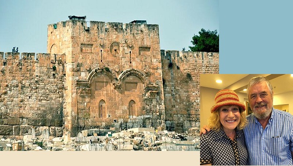
The Golden Gate is very much in the news today, as it has become a point of conflict between Jews and Muslims, or Palestinians and Israelis.
But what do we know about this gate?
The Golden Gate, around which swirl various traditions, is the most intriguing of all the gates of the Temple Mount. In Jewish tradition, it is through this gate (Sha’ar haRachamim—Gate of Mercy), blocked since the ninth century, that Messiah will enter at the end of days, led in by the prophet Elijah. This is based on the prophecy of Ezekiel 44.1–3. Christians believe that Christ made his triumphal entry into Jerusalem (recorded in all four of the gospels) through this gate on the Sunday before his crucifixion (Palm Sunday). By riding on a donkey, he fulfilled the messianic prophecy recorded in Zechariah 9.9. Muslims refer to it as the Gate of Eternity (Bab-al-Dahariyeh) and believe it will be an important part of the last judgment of mankind. The Muslim cemetery along the Eastern Wall is thought to have been placed there in the belief that the forerunner of Messiah, Elijah, being of a priestly family, could not pass through the Golden Gate, thus preventing the coming of the Messiah.
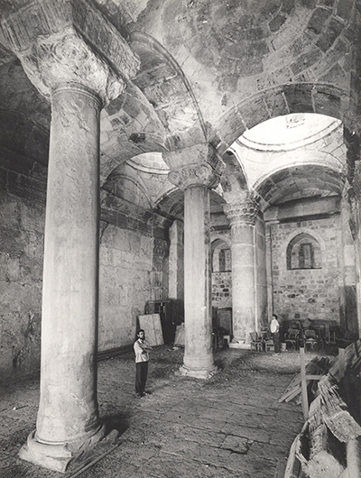
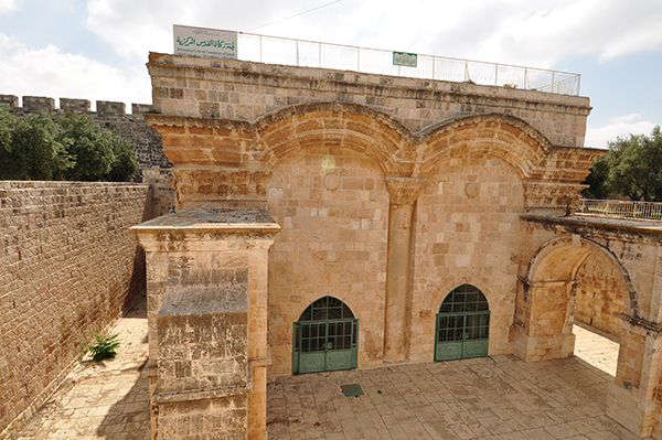
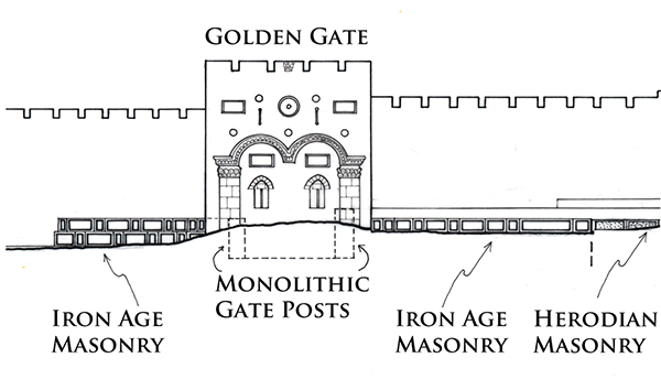
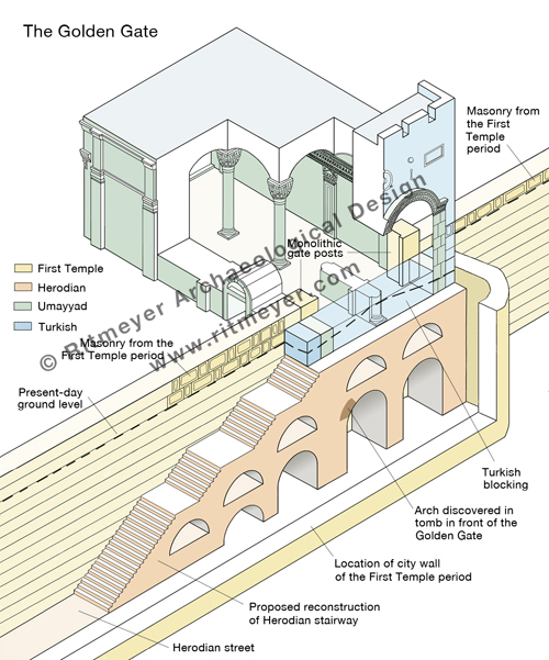
Some claim that the Golden Gate was built by the Byzantine emperor Heraclius after the expulsion of the Sassanians from Jerusalem. However, the absence in the architectural decorations of any Christian symbols, such as a cross makes that difficult to believe. There are actually four distinct historical phases represented in the architecture of this gate: Turkish, Umayyad, Herodian and First Temple period. In the 1970’s I was privileged to spend one week inside this gate, measuring and recording its plan and drawing accurate elevations of all the interior surfaces.
Standing in the middle of the Golden Gate interior. Two monolithic massive gateposts are visible in the far corners.
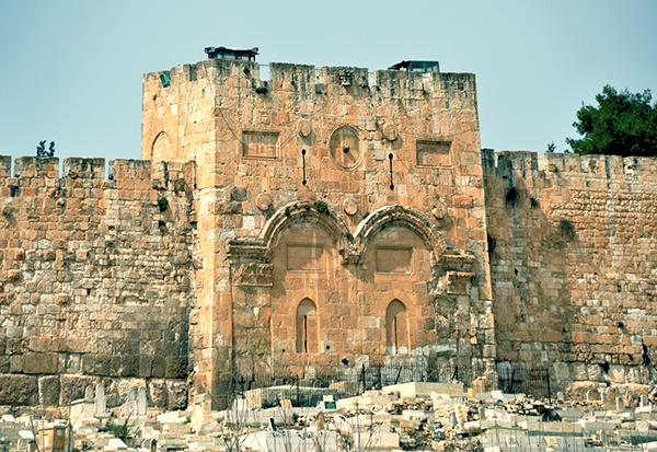
The Golden Gate’s outer façade is composed of two blocked-up gateways adorned with intricately carved relief arches. The decoration of the arches to the front and back of the gate are identical to the applied arches of the Double Gate which date from the Early Islamic period. The gate appears therefore to have been rebuilt in the Umayyad period, on the foundations of an earlier gate.
The exterior of the Golden Gate in the Eastern Wall of the Temple Mount in Jerusalem. Photo: Leen Ritmeyer
View of the Golden Gate from inside the Temple Mount. Photo: Nathaniel Ritmeyer
The remains of two massive monolithic gateposts are preserved inside this gate.
The gateposts are set in the same line as the Eastern Wall of the Temple Mount and line up with the massive masonry that can be seen on either side of the Golden Gate.
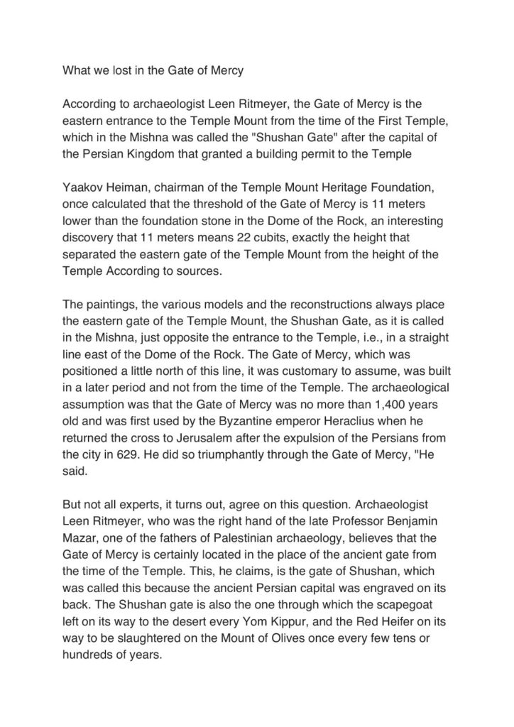
The gateposts and the two masonry sections appear therefore to be part of the same construction. The top of the southern gatepost is level with the top of the ancient masonry that can be seen south of the Golden Gate. The northern gatepost is one stone course higher and is located only one stone course below the surface of the Temple Mount. This means that the top of the original lintel would have been identical with the present-day level of the Temple Mount. The two gateposts belong to a gate that dates from the First Temple period and is most likely the Shushan Gate, mentioned in Mishnah Middot 1.3 as the only gate in the Eastern Wall.
The gate most probably was given this name by builders who had returned from exile in Babylon and for whom the Palace of Shushan lived on in their memories. However, if so there would have been a tradition of an eastern gate in this location from the time of the construction of the original Eastern Wall. It seems reasonable to suggest that the central section of the Eastern Wall dates from the First Temple period, in particular to the time of King Hezekiah. This square mount was extended south in the Hasmonean period, while both the southern and northern additions were made by King Herod the Great.
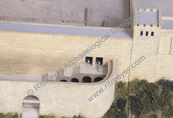
In 1969, the remains of an underground arch were discovered inside a grave in front of the Golden Gate. It was suggested that this may have been a pre-Herodian gateway. However, as the arch stones appear to be Herodian, it is more reasonable to suggest that this arch was part of a Herodian staircase leading up to the original gate. It is fascinating to contemplate that the stairway may still be intact under this gate, although hidden from sight by the Muslim Cemetery.
We do know that the remains of an ancient city wall lie under the present-day path that runs through the Muslim cemetery, which was discovered by Warren in the 1860s. The above-mentioned arched stairway led down through a gate in this city wall, the so-called Miphkad (Muster, or Inspection) Gate mentioned in Nehemiah 3.31, apparently still in use in the Second Temple period. During the latter period, it was through these gates that the Red Heifer was led out from the Temple Mount to the Mount of Olives (Mishnah, Parah). On the Day of Atonement, the scapegoat was led by the same route into the wilderness (Mishnah, Yoma).
It is therefore obvious that the Golden Gate is a very important historical building for the Jewish people, as reported by Arnon Segal of the Hebrew newspaper Makor Rishon Here is a translation of the article that refers to my research:
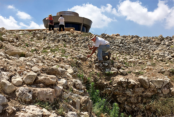
During the months of May/June 2017, excavations were carried out at Tel Shiloh[1]. At the conclusion of the dig, conservation work[2] needed to be carried out on some walls that were in danger of deterioration or collapse.
One section of the Middle Bronze Age city wall, W17 in Square AC-30, was selected for conservation. This wall was built of large ashlars, but in between these large stones were patches of small stones that needed to be consolidated (Fig. 1).
Fig. 1. The MBA city wall, W 17, before conservation. Note the many smaller stones that were placed in between the large ashlars.
Two new apps have been developed to help visitors visualize ancient Jerusalem, including the Temple Mount. The BYU has developed a free app, which can be downloaded here.
The Virtual New Testament app is one of the most accurate digital recreations of first-century Jerusalem. It’s purpose is to enhance scripture study by allowing you to experience the city, engage with the environment, and immerse yourself in the world of Jesus’ mortal ministry.
This app works for both Mac and Windows desktops and can be downloaded for mobile devices at the Apple App Store or at Google Play.
The Jewish News Online reported on another app that was developed by Lithodomos VR. This app only costs a couple of dollars and is worth getting if you have a Virtual Reality headset. An introduction can also be viewed on YouTube.
Young and old alike now have the chance to wander the streets of ancient Jerusalem, after archaeologists recreated the city at the time of King Herod in a virtual reality headset.
Half a million pounds of investor funding helped created the Android app, called Lithodomos VR, based on the archaeology of Temple Mount in 20BC, before it was destroyed some 90 years later.
The app (at £1.59 or S2.00) and headset let the user experience market streets, the Western Wall, the temple precinct, and the Jewish and Roman period districts, with buildings virtually reconstructed based on the latest archaeological evidence.
On Sunday, the 10th of April, 2017, the Jewish people begin celebrating Pesach – Jewish Passover. That is one week earlier than Easter. However, in this blog post we would like to remember the time that Jesus as a twelve-year-old visited the Temple during Passover for the first time in his life.
Reconstruction drawing showing young Jesus (in blue) on the steps of the Temple Terrace (ḥel) with the rabbis.
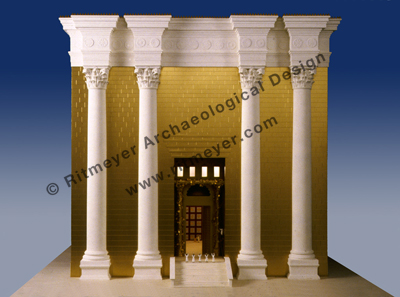
The Temple in the time of Christ was a magnificent building. From the Temple Court (azarah), 12 steps led up to the Porch that was as high as the Temple itself. In front of the entrance to the Sanctuary, a Golden Vine was attached to four columns.
According to Josephus, Herod’s Temple looked like a snow-clad mountain, for all that was not overlaid with gold was of the purest white and it lacked nothing that could astound either mind or eye. No wonder that some of Jesus’ disciples remarked “how the Temple was adorned with beautiful stones and with gifts dedicated to God” (Matthew 24.1; Luke 21.5).
The central feature of this complex, the Holy of Holies, was located deep inside, at the west end of the Sanctuary. No one could enter this place of utmost sanctity but the High Priest once a year on the Day of Atonement. A veil separated the Holy of Holies from a place of lesser sanctity, the Holy Place.
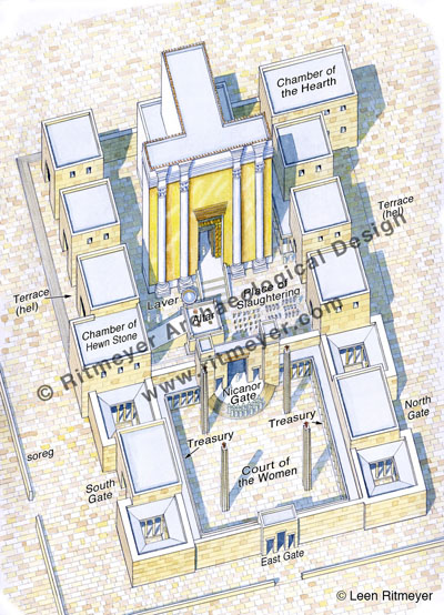
The Temple Court lay in front of the Temple and it contained the Altar, the Laver and the Place of Slaughtering (or Shambles). This was the closest court to the Temple and out of bounds to anyone like Jesus who was not a priest.
This reconstruction drawing shows the Temple, viewed from the east. It was surrounded by a court, called the Temple Court or azarah in Hebrew. In front of the Temple stood the Altar, the Laver (Basin) and the pillars and tables that were used in the preparation of sacrifices. Several gates and other buildings stood to the north and south of the Temple.
This Temple Court was separated by the Nicanor Gate from the Court of Women, which lay to the east of the Temple. Buildings, called gates, surrounded this complex. In front of the gates was a terrace (ḥel – pronounced chel with the “ch” sounding guttural as in the Scottish “loch”) of 10 cubits wide, which was reached by a flight of steps of half a cubit high and deep. This terrace bounded the wall of the gate buildings on their southern, western and northern sides.
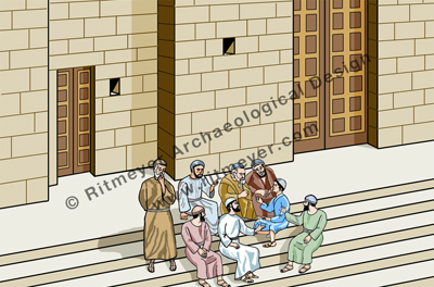
Reconstruction model of the Temple Mount, showing the southern terrace (ḥel). The little blue figure at middle right represents young Jesus.
It is on this ḥelthat we get our first glimpse of Jesus after the birth narratives in the Gospels. Scripture is silent about his youth although it is clear from the observations of nature and Biblical history later attributed to him by the Gospel writers that he absorbed every spiritual and historical lesson that was provided by his upbringing in the countryside around Nazareth.
Now he was twelve years of age and his first words are recorded for us (Luke 2. 41-52). Under the law, attendance at the feasts in Jerusalem was obligatory for boys from the age of thirteen, a birthday that was a milestone in the life of a Jewish boy, when they became a Son of the Commandment or Bar Mitzvah. In practice, this legal age was pushed forward by one or two years so that Jesus, after he had passed his twelfth year, came up to Jerusalem for the Passover with his family. Jesus’ first view of the Temple must have filled him with a great sense of the purpose he had been developing during the quiet years in Nazareth. Attendance at the Temple was obligatory only for the first two days of Passover, after which many of the pilgrims would have returned home again. It would appear that Joseph and Mary and their “company” did indeed start to return home and had travelled for a day. When they finally realized that Jesus was missing, it took them three days to find him and when they did, he was “in the temple, sitting in the midst of the doctors, both hearing them and asking them questions.” The ḥel is the only place in the Temple he could have been.
We learn this from a tractate of the Babylonian Talmud, Sanhedrin 88b, which tells us:
“It has been taught; R. Jose said; Originally there were not many disputes in Israel, but one Beth din of seventy-one members sat in the Hall of Hewn Stones, and two courts of twenty-three sat, one at the entrance of the Temple Mount and one at the door of the [Temple] Court, and other courts of twenty-three sat in all Jewish cities.” “The Great Sanhedrin] sat from the morning tamid (daily sacrifice) until the evening tamid [in the Hall of Hewn Stones]; on Sabbaths and festivals they sat within the ḥel.”
So, Passover would have been one such festival when members of the Temple Sanhedrin would come out to teach in this area. Ordinary people, who normally had no access to the classrooms where young priests were taught, could come and question them. Jesus must have eagerly made use of this opportunity and never would they have had such a sharp student as him. During this visit to the Temple, he would have seen the preparations for sacrificing the Passover lambs and realized, perhaps for the first time in his young life, that the entire ritual pointed forward to his own sacrifice. He would have been so absorbed by all these experiences that he would not have wanted to leave. He forgot about his natural family, for here he was at home – in his Father’s house.
As we have written extensively on the Temple Mount it was difficult to give a new slant to this book without repeating ourselves too much. We therefore decided to go back in history and see where the idea of holiness and a sanctuary came from. We found it in the Book of Genesis.
In the early chapters of Genesis we read that God created a garden in Eden and placed Adam and Eve in it to look after it. God Himself walked in this garden (Gen. 3:8) and therefore it represented the dwelling place of God, comparable to the Holy of Holies of the later Tabernacle and Jerusalem Temples. God spoke in the Garden of Eden and also in the Holy of Holies that is sometimes called debir (oracle, derived from dabar, to speak). A similar expression of God walking in a sacred space is used of the Tabernacle (Lev. 26:11,12):
And I will set my tabernacle among you: and my soul shall not abhor you. And I will walk among you, and will be your God, and ye shall be my people.
One of the earliest extra-biblical references to the Garden of Eden being a representation of the Temple comes from the apocryphal Book of Jubilees 8:19:
“[Noah] knew that the Garden of Eden is the holy of holies, and the dwelling place of the Lord.”
Adam was given a charge to dress (abad —work) and keep (shamar —watch) the garden:
And the LORD God took the man, and put him into the Garden of Eden to dress it and to keep it. (Gen. 2:15)
The Hebrew verbs ‘to dress’ and ‘to keep’ are also used to describe the work of the priests in the Tabernacle (Num. 3:6,7):
Bring the tribe of Levi near, and present them before Aaron the priest, that they may minister unto him. And they shall keep his charge (derived from shamar), and the charge of the whole congregation before the tabernacle of the congregation, to do the service (derived from abad) of the tabernacle.
It could be suggested therefore that Adam was given a priestly duty to look after this garden-sanctuary.
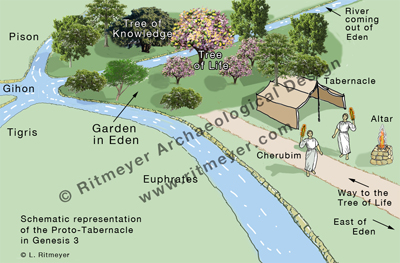
A schematic representation of the Genesis Sanctuary, showing the Garden of Eden with four rivers coming out of it and the proto-Tabernacle with the cherubim and an altar.
After Adam and Eve were exiled from the Garden of Eden, cherubim with a flaming sword that turned in all directions were placed to the east of the garden to prevent their return. In Hebrew, the word “placed” (yasken), in Genesis 3:24, is closely related to the word for Tabernacle, which is mishkan in Hebrew. The original language appears to indicate that the cherubim were made to dwell in a tent-sanctuary or tabernacle that was erected to the east of the Garden of Eden. Although little else is known about this sanctuary, the text would seem to be describing a proto-Tabernacle or Genesis Sanctuary, which would serve as a model for future meeting places between God and man.
East-facing Sanctuary
The location of the sanctuary at the east side of the garden can be compared to that of the Holy Place of the later sanctuaries of Israel. The forbidden Paradise lay therefore to the west of the guarded entrance to the Garden of Eden. A road may have run from the east to an entry point or gate in a boundary that surrounded the Garden of Eden. Here the principles of worship would have been established, creating a pattern for subsequent places of worship. Anyone wanting to visit this dwelling place would have had to approach it from the east and face west. This direction of approaching a holy place from the east has been preserved in the Tabernacle and the Temple constructions, the entrances of which all faced east, while the Holy of Holies is in the west.
The Altar
The principle of approaching God by sacrifice would also have been established in this place. The sword of the cherubim may have been used, not only to preserve the way to the Tree of Life by keeping humans out, but also for killing sacrifices and the flame for igniting the wood. It would be reasonable to suggest that the offerings that Cain and Abel brought to God were presented to these cherubim. Abel may have placed his offering on an altar. It was in this place that the cherubim, as divine representatives, would have taught Cain and Abel which sacrifices were acceptable and which ones were not. In the New Testament Book of Hebrews 11:4, we are told that God testified of Abel’s gift. Was this testifying done by the fire of the cherubim consuming Abel’s sacrifice? A similar event happened with the sacrifices brought by Gideon (Judges 6.21) and Elijah (1 Kings 18.38).
Thinking about this proto-Sanctuary in Genesis, we can see that the principles of holiness were laid out right in the beginning of the Hebrew Bible. There are many other parallels with the later Sanctuaries of Israel that are mentioned in this book. It appears, however, reasonable to suggest that this bi-partite division of a Holy of Holies and a Holy Place may have become a blueprint for later Israelite and non-Israelite sanctuaries alike.
For further reading on this topic, see:
Parry, D.W. (ed.) (1994). Temples of the Ancient World: Ritual and Symbolism (Salt Lake City).
Beale, G.K., (2004). The Temple and the Church’s Mission, a biblical theology of the dwelling place of God (Leicester).
Hamblin, W.J., (2007). Solomon’s Temple: Myth and History (London).
Beale, G.K., (2011). A New Testament Biblical Theology: The Unfolding of the Old Testament in the New (Grand Rapids).
Price, R. (2012). Rose Guide to the Temple (Torrance).
Spreading the chart out on the table, we were able to retrace many of the trips and explorations we made when living in Jerusalem. At the time, some of these had required poring over Ordnance Survey maps and reading archaeological reports before we could identify the sites involved. Now, with the acquisition of this map, we can easily find the location of these sites, as well as, and most importantly, the latest sites to have been discovered.
Twenty-three years ago, the publication of the New Encyclopedia of Archaeological Excavations in the Holy Land, a a joint venture by the Israel Exploration Society, Carta, and Simon and Schuster’s Academic Reference Division, was a landmark in the quest to provide a comprehensive work that would summarize the results of archaeological work in the Land of Israel for the English reader. It had a 102-page long section on Jerusalem. Ephraim Stern wrote in the Editor’s Foreword to the Supplementary Volume, published in 2008:
“Since the publication in 1993 of the four volumes of the New Encyclopedia of Archaeological Excavations in the Holy Land (NEAEH) archaeological excavations have continued at a staggering pace. Many of the entries of those four volumes quickly became outdated and the need arose for this volume, which updates the NEAEH to the year 2005. It is a joint venture of the Israel Exploration Society and the Biblical Archaeology Society.”
So, while we await the next update, a mammoth undertaking, this handily portable map will play a vital role in guiding the visitor around the archaeological sites of Jerusalem,
The front part of this large map (63×94 cm, or 25×37 inches) shows the Old City and its surroundings, while the reverse side is dedicated to the Old City in much greater detail. The map was made in collaboration with the IAA (Israel Antiquities Authority, or Reshut Atiqot in Hebrew), with the text and scientific advice provided by Dr. Yuval Baruch. The archaeological sites are described in small text boxes with an arrow pointing to the exact location of each.
Most of the sites on the front part are familiar to us, but by no means all of them are. It is good to see the site of Lifta on the northwest of the city included. This has been identified as the site of the Waters of Nephtoah of Joshua 15.9 and 18.15, defining here the border between Benjamin and Judah. We remember exploring the village and its spring in the 1970’s, but then it seemed very much off the beaten track, being hidden away on two steep slopes in the last valley of the ascent into Jerusalem.
There are other sites we are not so familiar with such as Khirbet Adaseh North and Khirbet Adaseh, 2 miles to the southeast. Adasa, was, of course, the place where the Maccabees were victorious in their battle against the Seleucid general Nicanor, who lost his life there.
The Old City map is also informative with sections dedicated to the Kidron and Hinnom Valleys, Mount Zion, the City of David and the Aqueducts of Jerusalem. We are pleased that the Tomb of Annas the High Priest, a site we were able to identify in the early 1990’s, is included among the sites in the Hinnom Valley.
This drawing shows the Tomb of Annas as reconstructed according to the archaeological remains. The reconstruction drawing shows the triple-gated entrance to the tomb’s anteroom. This is based on the remains of the partly preserved semi-hemispherical conch above the central doorway and those of four pilasters, the outer ones showing an additional rounded moulding which was part of a frame. There are indications that the tomb once carried a superstructure and so could be identified as a monument.
A glaring omission on this side of the map is any detail on the vast platform of the Temple Mount. However, giving the impression that the site is a terra incognita is part of the political reality in this area. Only some of the gates are mentioned, with the Double and Triple Gates unfortunately still called the Huldah Gates. The original Huldah Gates were in fact located in the southern wall of the pre-Herodian Temple Mount some 72 m (240 ft) north of the present Southern Wall.
No reference is made to the Step, which is the remains of the Western Wall of King Hezekiah’s Square Temple Mount or of The Rock, identified by many as the site of the Holy of Holies of Solomon’s Temple. The many well-heads visible on the platform indicate the location of the many underground cisterns, of which two, Cisterns 6 and 36, may have been mikva’ot. These would also have added interest to this part of the map.
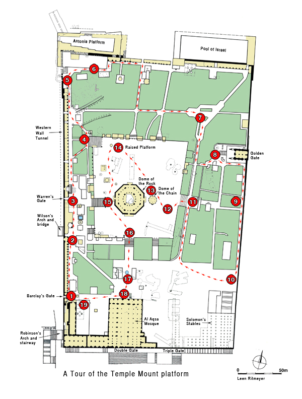
Information on the Temple Mount platform is, however, available in our guide bookJerusalem, the Temple Mount in which we have produced a map showing 19 points of archaeological and historical interest:
Despite these shortcomings, however, we foresee copies of this map being given as presents for those who love exploring the Old City of Jerusalem and its environs. And if you have friends visiting who have been to Jerusalem, framed reproductions are bound to stimulate some lively conversation.